Volcanism of Northern Canada

Last updated
Volcanism of Northern Canada
Northern Canada map.svg
Northern Canada, defined politically.
Geography
LocationYukon, Canada
Geology
Type of rock Volcanism

Volcanism of Northern Canada has produced hundreds of volcanic areas and extensive lava formations across Northern Canada. The region's different volcano and lava types originate from different tectonic settings and types of volcanic eruptions, ranging from passive lava eruptions to violent explosive eruptions. Northern Canada has a record of very large volumes of magmatic rock called large igneous provinces. They are represented by deep-level plumbing systems consisting of giant dike swarms, sill provinces and layered intrusions.

Contents

Plume and rift complexes

Map of the 1,267-million-year-old Mackenzie dike swarm (black lines). Dots indicate areas where flow direction was determined. Red arcuate line indicates boundary between vertical flow and horizontal flow. Mackenzie dike swarm.png
Map of the 1,267-million-year-old Mackenzie dike swarm (black lines). Dots indicate areas where flow direction was determined. Red arcuate line indicates boundary between vertical flow and horizontal flow.

Vast volumes of basaltic lava covered Northern Canada in the form of a flood basalt event 1,267 million years ago that engulfed the landscape near the Coppermine River southwest of Coronation Gulf in the Canadian Arctic. [1] This volcanic activity built an extensive lava plateau and large igneous province with an area of 170,000 km2 (65,637 sq mi) representing a volume of lavas of at least 500,000 km3 (119,956 cu mi). [1] With an area of 170,000 km2 (65,637 sq mi) and a volume of 500,000 km3 (119,956 cu mi), it is larger than the Columbia River Basalt Group in the United States and comparable in size to the Deccan Traps in west-central India, making it one of the largest flood basalt events ever to appear on the North American continent, as well as on Earth.

This massive eruptive event was associated with the Mackenzie magmatic event, that included the coeval, layered, mafic-ultramafic Muskox intrusion and the enormous Mackenzie dike swarm that diverges from the Coppermine River Group flood basalts. [2] The maximum thickness of the flood basalts are 4.7 km (3 mi) and consist of 150 lava flows, each 4 m (13 ft) to 100 m (328 ft) thick. [2] These flood basalt lava flows were erupted during a single event that lasted less than five million years. [2] Analysis of the chemical composition of the lavas gives important clues about the origin and dynamics of the flood basalt volcanism. [2] The lowermost lavas were produced by melting in the garnet stability field below the surface at a depth of more than 90 km (56 mi) in a mantle plume environment beneath the North American lithosphere. [2] As the mantle plume intruded rocks of the Canadian Shield, it created an upwelling zone of molten rock known as the Mackenzie hotspot. Upper lavas were partly contaminated with crustal rocks as magmas from the mantle plume passed through the lower and upper crust. [2]

During the Early Jurassic period 196 million years ago, the New England or Great Meteor hotspot existed in the Rankin Inlet area of southern Nunavut along the northwestern coast of Hudson Bay, producing kimberlite magmas. [3] This marks the first appearance of the New England hotspot, as well as the oldest kimberlite eruption throughout the New England or Great Meteor hotspot track, which extends southeastwards across Canada and enters the northern Atlantic Ocean where the New England hotspot is located. [3]

Dragon Cliff on western Axel Heiberg Island is made of flood basalt lava flows of the Strand Fiord Formation Dragon Cliffs, Nunavut.jpg
Dragon Cliff on western Axel Heiberg Island is made of flood basalt lava flows of the Strand Fiord Formation

The Sverdrup Basin Magmatic Province of northern Nunavut forms a large igneous province 95 to 92 million years old in the Canadian Arctic. [4] Part of the larger High Arctic Large Igneous Province, it consists of two volcanic formations called the Ellesmere Island Volcanics and Strand Fiord Formation. In the Strand Fiord Formation, flood basalt lavas reach a thickness of at least 1 km (1 mi). [4] Flood basalts of the Sverdrup Basin Magmatic Province are similar to terrestrial flood basalts associated with breakup of continents, indicating the Sverdrup Basin Magmatic Province formed as a result of rifting of the Arctic Ocean and when the large underwater Alpha Ridge was still geologically active. [4]

Widespread basalt volcanism occurred between 60.9 and 61.3 million years ago in the northern Labrador Sea, Davis Strait and in southern Baffin Bay on the eastern coast of Nunavut during the Paleocene period when North America and Greenland were being separated by tectonic movements. This resulted from seafloor spreading where new ocean seafloor was being created from rising magma. Scientific studies have indicated nearly 80% of the magma was erupted in one million years or less. [5]

The source for this volcanic activity was the Iceland plume along with its surface expression, the Iceland hotspot. [5] This volcanic activity formed part of a large igneous province that is now sunken beneath the northern Labrador Sea. [5] Another period of volcanic activity began in the same region about 55 million years ago during the Eocene period when the north-south trending Mid-Atlantic Ridge began to form under the northern Atlantic Ocean east of Greenland. The cause of this volcanism might be related to partial melting from movement of a transform fault system extending from Labrador Sea to the south and Baffin Bay to the north. [5]

Although the region was carried away from the Iceland plume by continuing plate motion over millions of years, the source of the partial melting for the final period of volcanic activity may have been remnants of still anomalously hot Iceland plume magma which were left stranded beneath the North American lithosphere in the Paleocene period. [5] Most diatremes in the Northwest Territories were formed by volcanic eruptions between 45 and 75 million years ago during the Eocene and Late Cretaceous periods.

The Yukon portion of the northwest trending Northern Cordilleran Volcanic Province includes the youngest volcanoes in Northern Canada. The Fort Selkirk Volcanic Field in central Yukon consists of valley-filling basalt lava flows and cinder cones. [6] Ne Ch'e Ddhawa, a cinder cone 2 km (1 mi) to the connection of the Yukon and Pelly rivers formed between 0.8 and one million years ago when this area lay beneath the vast Cordilleran Ice Sheet. [7]

The youngest volcano, Volcano Mountain just north of the junction of the Yukon and Pelly rivers, formed in the past 10,000 years (Holocene), producing lava flows that remain unvegetated and appear to be only a few hundred years old. [6] However, dating of sediments in a lake impounded by the lava flows indicated that the youngest lava flows could not be younger than mid-Holocene and could be early Holocene or older. [6] Therefore, the most recent activity in the Fort Selkirk volcanic field is unknown. [6] The lava flows from Volcano Mountain are unusual because they originate much deeper in the Earth's mantle than the more common basaltic lava flows found throughout the Yukon and are very uncommon in the geological record. [8] This lava, known as olivine nephelinite, is also unusual because it contains small, angular to rounded fragments of rock called nodules. [8]

Subduction complexes

More recent volcanic activity has created a northwest trending line of volcanic rocks called the Wrangell Volcanic Belt. [9] This volcanic belt lies largely in the U.S. state of Alaska, but extends across the Alaska-Yukon border into southwestern Yukon where it contains scattered remnants of subaerial lavas and pyroclastic rocks which are preserved along the entire eastern fringe of the ice covered Saint Elias Mountains. [9]

The Wrangell Volcanic Belt formed as a result of arc volcanism related to subduction of the Pacific Plate under the northern portion of the North American Plate. [9] Over large areas extrusive rocks lie in flat undisturbed piles on a Tertiary surface of moderate relief. [9] Locally, however, strata of the same age have been affected by a late pulse of tectonism, during which they were faulted, contorted into tight symmetrical folds, or overridden by pre-Tertiary basement rocks along southwesterly dipping thrust faults. [9]

Considerable recent uplift, accompanied by rapid erosion, has reduced once vast areas of upper Tertiary volcanic rocks to small isolated remnants. [9] Although no eruptions have occurred in the Yukon portion of the Wrangell Belt for the past five million years, two large (VEI-6) explosive eruptions from Mount Churchill 24 km (15 mi) west of the Alaska-Yukon border, created the White River Ash deposit. [10] This volcanic ash deposit is estimated 1,890 and 1,250 years old, covering more than 340,000 km2 (130,000 sq mi) of northwestern Canada and adjacent eastern Alaska. [10] Unproven legends from indigenous people in the area indicate the final eruption from Mount Churchill 1,250 years ago disrupted food supplies and forced them to move further south. [10]

See also

Related Research Articles

<span class="mw-page-title-main">Yellowstone Caldera</span> Volcanic caldera in Yellowstone National Park in the United states

The Yellowstone Caldera, sometimes referred to as the Yellowstone Supervolcano, is a volcanic caldera and supervolcano in Yellowstone National Park in the Western United States. The caldera and most of the park are located in the northwest corner of Wyoming. The caldera measures 43 by 28 miles, and postcaldera lavas spill out a significant distance beyond the caldera proper.

<span class="mw-page-title-main">Anahim Volcanic Belt</span> Chain of volcanoes and related magmatic features in British Columbia, Canada

The Anahim Volcanic Belt (AVB) is a west–east trending chain of volcanoes and related magmatic features in British Columbia, Canada. It extends from Athlone Island on the Central Coast, running eastward through the strongly uplifted and deeply dissected Coast Mountains to near the community of Nazko on the Interior Plateau. The AVB is delineated as three west-to-east segments that differ in age and structure. A wide variety of igneous rocks with differing compositions occur throughout these segments, comprising landforms such as volcanic cones, volcanic plugs, lava domes, shield volcanoes and intrusions.

<span class="mw-page-title-main">Flood basalt</span> Very large volume eruption of basalt lava

A flood basalt is the result of a giant volcanic eruption or series of eruptions that covers large stretches of land or the ocean floor with basalt lava. Many flood basalts have been attributed to the onset of a hotspot reaching the surface of the Earth via a mantle plume. Flood basalt provinces such as the Deccan Traps of India are often called traps, after the Swedish word trappa, due to the characteristic stairstep geomorphology of many associated landscapes.

<span class="mw-page-title-main">Large igneous province</span> Huge regional accumulation of igneous rocks

A large igneous province (LIP) is an extremely large accumulation of igneous rocks, including intrusive and extrusive, arising when magma travels through the crust towards the surface. The formation of LIPs is variously attributed to mantle plumes or to processes associated with divergent plate tectonics. The formation of some of the LIPs in the past 500 million years coincide in time with mass extinctions and rapid climatic changes, which has led to numerous hypotheses about causal relationships. LIPs are fundamentally different from any other currently active volcanoes or volcanic systems.

<span class="mw-page-title-main">Yellowstone hotspot</span> Volcanic hotspot in the United States

The Yellowstone hotspot is a volcanic hotspot in the United States responsible for large scale volcanism in Idaho, Montana, Nevada, Oregon, and Wyoming, formed as the North American tectonic plate moved over it. It formed the eastern Snake River Plain through a succession of caldera-forming eruptions. The resulting calderas include the Island Park Caldera, Henry's Fork Caldera, and the Bruneau-Jarbidge caldera. The hotspot currently lies under the Yellowstone Caldera. The hotspot's most recent caldera-forming supereruption, known as the Lava Creek Eruption, took place 640,000 years ago and created the Lava Creek Tuff, and the most recent Yellowstone Caldera. The Yellowstone hotspot is one of a few volcanic hotspots underlying the North American tectonic plate; another example is the Anahim hotspot.

<span class="mw-page-title-main">Iceland hotspot</span> Hotspot partly responsible for volcanic activity forming the Iceland Plateau and island

The Iceland hotspot is a hotspot which is partly responsible for the high volcanic activity which has formed the Iceland Plateau and the island of Iceland.

<span class="mw-page-title-main">Northern Cordilleran Volcanic Province</span> Geologic province in the Pacific Northwest of North America

The Northern Cordilleran Volcanic Province (NCVP), formerly known as the Stikine Volcanic Belt, is a geologic province defined by the occurrence of Miocene to Holocene volcanoes in the Pacific Northwest of North America. This belt of volcanoes extends roughly north-northwest from northwestern British Columbia and the Alaska Panhandle through Yukon to the Southeast Fairbanks Census Area of far eastern Alaska, in a corridor hundreds of kilometres wide. It is the most recently defined volcanic province in the Western Cordillera. It has formed due to extensional cracking of the North American continent—similar to other on-land extensional volcanic zones, including the Basin and Range Province and the East African Rift. Although taking its name from the Western Cordillera, this term is a geologic grouping rather than a geographic one. The southmost part of the NCVP has more, and larger, volcanoes than does the rest of the NCVP; further north it is less clearly delineated, describing a large arch that sways westward through central Yukon.

<span class="mw-page-title-main">Columbia River Basalt Group</span> Continental flood basalt province in the Western United States

The Columbia River Basalt Group (CRBG) is the youngest, smallest and one of the best-preserved continental flood basalt provinces on Earth, covering over 210,000 km2 (81,000 sq mi) mainly eastern Oregon and Washington, western Idaho, and part of northern Nevada. The basalt group includes the Steens and Picture Gorge basalt formations.

<span class="mw-page-title-main">Level Mountain</span> Volcanic complex in British Columbia, Canada

Level Mountain is a large volcanic complex in the Northern Interior of British Columbia, Canada. It is located 50 kilometres north-northwest of Telegraph Creek and 60 kilometres west of Dease Lake on the Nahlin Plateau. With a maximum elevation of 2,164 metres, it is the second-highest of four large complexes in an extensive north–south trending volcanic region. Much of the mountain is gently-sloping; when measured from its base, Level Mountain is about 1,100 metres tall, slightly taller than its neighbour to the northwest, Heart Peaks. The lower, broader half of Level Mountain consists of a shield-like structure while its upper half has a more steep, jagged profile. Its broad summit is dominated by the Level Mountain Range, a small mountain range with prominent peaks cut by deep valleys. These valleys serve as a radial drainage for several small streams that flow from the mountain. Meszah Peak is the only named peak in the Level Mountain Range.

<span class="mw-page-title-main">Volcanism of Canada</span> Volcanic activity in Canada

Volcanic activity is a major part of the geology of Canada and is characterized by many types of volcanic landform, including lava flows, volcanic plateaus, lava domes, cinder cones, stratovolcanoes, shield volcanoes, submarine volcanoes, calderas, diatremes, and maars, along with less common volcanic forms such as tuyas and subglacial mounds.

The Anahim hotspot is a hypothesized hotspot in the Central Interior of British Columbia, Canada. It has been proposed as the candidate source for volcanism in the Anahim Volcanic Belt, a 300 kilometres long chain of volcanoes and other magmatic features that have undergone erosion. This chain extends from the community of Bella Bella in the west to near the small city of Quesnel in the east. While most volcanoes are created by geological activity at tectonic plate boundaries, the Anahim hotspot is located hundreds of kilometres away from the nearest plate boundary.

<span class="mw-page-title-main">Geology of the Pacific Northwest</span> Geology of Oregon and Washington (United States) and British Columbia (Canada)

The geology of the Pacific Northwest includes the composition, structure, physical properties and the processes that shape the Pacific Northwest region of North America. The region is part of the Ring of Fire: the subduction of the Pacific and Farallon Plates under the North American Plate is responsible for many of the area's scenic features as well as some of its hazards, such as volcanoes, earthquakes, and landslides.

<span class="mw-page-title-main">Paraná and Etendeka traps</span> Large igneous province in South America and Africa

The Paraná-Etendeka Large Igneous Province (PE-LIP) (or Paraná and Etendeka Plateau; or Paraná and Etendeka Province) is a large igneous province that includes both the main Paraná traps (in Paraná Basin, a South American geological basin) as well as the smaller severed portions of the flood basalts at the Etendeka traps (in northwest Namibia and southwest Angola). The original basalt flows occurred 136 to 132 million years ago. The province had a post-flow surface area of 1,000,000 square kilometres (390,000 sq mi) and an original volume projected to be in excess of 2.3 x 10⁶ km³.

<span class="mw-page-title-main">Caribbean large igneous province</span> Accumulation of igneous rocks

The Caribbean large igneous province (CLIP) consists of a major flood basalt, which created this large igneous province (LIP). It is the source of the current large eastern Pacific oceanic plateau, of which the Caribbean-Colombian oceanic plateau is the tectonized remnant. The deeper levels of the plateau have been exposed on its margins at the North and South American plates. The volcanism took place between 139 and 69 million years ago, with the majority of activity appearing to lie between 95 and 88 Ma. The plateau volume has been estimated as on the order of 4 x 10⁶ km³. It has been linked to the Galápagos hotspot.

<span class="mw-page-title-main">North Atlantic Igneous Province</span> Large igneous province in the North Atlantic, centered on Iceland

The North Atlantic Igneous Province (NAIP) is a large igneous province in the North Atlantic, centered on Iceland. In the Paleogene, the province formed the Thulean Plateau, a large basaltic lava plain, which extended over at least 1.3 million km2 (500 thousand sq mi) in area and 6.6 million km3 (1.6 million cu mi) in volume. The plateau was broken up during the opening of the North Atlantic Ocean leaving remnants preserved in north Ireland, west Scotland, the Faroe Islands, northwest Iceland, east Greenland, western Norway and many of the islands located in the north eastern portion of the North Atlantic Ocean. The igneous province is the origin of the Giant's Causeway and Fingal's Cave. The province is also known as Brito–Arctic province and the portion of the province in the British Isles is also called the British Tertiary Volcanic Province or British Tertiary Igneous Province.

<span class="mw-page-title-main">Volcanism on Mars</span> Overview of volcanism in the geological history of Mars

Volcanic activity, or volcanism, has played a significant role in the geologic evolution of Mars. Scientists have known since the Mariner 9 mission in 1972 that volcanic features cover large portions of the Martian surface. These features include extensive lava flows, vast lava plains, and the largest known volcanoes in the Solar System. Martian volcanic features range in age from Noachian to late Amazonian, indicating that the planet has been volcanically active throughout its history, and some speculate it probably still is so today. Both Earth and Mars are large, differentiated planets built from similar chondritic materials. Many of the same magmatic processes that occur on Earth also occurred on Mars, and both planets are similar enough compositionally that the same names can be applied to their igneous rocks and minerals.

<span class="mw-page-title-main">Volcanism of Eastern Canada</span>

The volcanism of Eastern Canada includes the hundreds of volcanic areas and extensive lava formations in Eastern Canada. The region's different volcano and lava types originate from different tectonic settings and types of volcanic eruptions, ranging from passive lava eruptions to violent explosive eruptions. Eastern Canada has very large volumes of magmatic rock called large igneous provinces. They are represented by deep-level plumbing systems consisting of giant dike swarms, sill provinces and layered intrusions. The most capable large igneous provinces in Eastern Canada are Archean age greenstone belts containing a rare volcanic rock called komatiite.

<span class="mw-page-title-main">Volcanic history of the Northern Cordilleran Volcanic Province</span>

The volcanic history of the Northern Cordilleran Volcanic Province presents a record of volcanic activity in northwestern British Columbia, central Yukon and the U.S. state of easternmost Alaska. The volcanic activity lies in the northern part of the Western Cordillera of the Pacific Northwest region of North America. Extensional cracking of the North American Plate in this part of North America has existed for millions of years. Continuation of this continental rifting has fed scores of volcanoes throughout the Northern Cordilleran Volcanic Province over at least the past 20 million years and occasionally continued into geologically recent times.

<span class="mw-page-title-main">Mackenzie Large Igneous Province</span>

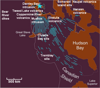
The Mackenzie Large Igneous Province (MLIP) is a major Mesoproterozoic large igneous province of the southwestern, western and northwestern Canadian Shield in Canada. It consists of a group of related igneous rocks that were formed during a massive igneous event starting about 1,270 million years ago. The large igneous province extends from the Arctic in Nunavut to near the Great Lakes in Northwestern Ontario where it meets with the smaller Matachewan dike swarm. Included in the Mackenzie Large Igneous Province are the large Muskox layered intrusion, the Coppermine River flood basalt sequence and the massive northwesterly trending Mackenzie dike swarm.

<span class="mw-page-title-main">North Arch volcanic field</span> Underwater volcanic field north of Oahu, Hawaii

North Arch volcanic field is an underwater volcanic field north of Oahu, Hawaii. It covers an area of about 25,000 square kilometres (9,700 sq mi) and consists of large expanses of alkali basalt, basanite and nephelinite that form extensive lava flows and volcanic cones. Some lava flows are longer than 100 kilometres (62 mi).

References

  1. 1 2 Lambert, Maurice B. (1978). Volcanoes . North Vancouver, British Columbia: Energy, Mines and Resources Canada. ISBN   0-88894-227-3.
  2. 1 2 3 4 5 6 Yoshida, M.; B. F. Windley; S. Dasgupta (2003). Proterozoic East Gondwana: Supercontinent Assembly and Breakup. The Geological Society. p. 26. ISBN   1-86239-125-4.
  3. 1 2 Condie, Kent C. (2001). Mantle Plumes and Their Record in Earth History. Cambridge University Press. p. 21. ISBN   0-521-01472-7.
  4. 1 2 3 [ permanent dead link ]
  5. 1 2 3 4 5 Storey, M; Duncan, R.A; Pedersen, A.K; Larsen, L.M; Larsen, H.C (1998), "40Ar/39Ar geochronology of the West Greenland Tertiary volcanic province", Earth and Planetary Science Letters, 160 (3–4): 569, doi:10.1016/S0012-821X(98)00112-5
  6. 1 2 3 4 "Fort Selkirk". Global Volcanism Program . Smithsonian Institution . Retrieved 2009-01-24.
  7. "IPY GeoNorth 2007". Northern Landscapes. Natural Resources Canada. 2007-04-25. Retrieved 2009-01-24.[ dead link ]
  8. 1 2 "Stikine volcanic belt: Volcano Mountain". Catalogue of Canadian volcanoes. Geological Survey of Canada. 2008-02-13. Archived from the original on 2009-03-07. Retrieved 2009-01-24.
  9. 1 2 3 4 5 6 Wood, Charles A.; Kienle, Jürgen (1990). Volcanoes of North America: United States and Canada. Cambridge, England: Cambridge University Press. pp. 111, 112, 113, 114, 115, 124, 126, 135, 136. ISBN   0-521-43811-X.
  10. 1 2 3 "Mount Churchill". Catalogue of Canadian volcanoes. Geological Survey of Canada. 2005-08-19. Archived from the original on 2009-06-08. Retrieved 2009-02-19.