
Canada has a vast geography that occupies much of the continent of North America, sharing a land border with the contiguous United States to the south and the U.S. state of Alaska to the northwest. Canada stretches from the Atlantic Ocean in the east to the Pacific Ocean in the west; to the north lies the Arctic Ocean. Greenland is to the northeast with a shared border on Hans Island. To the southeast Canada shares a maritime boundary with France's overseas collectivity of Saint Pierre and Miquelon, the last vestige of New France. By total area, Canada is the second-largest country in the world, after Russia. By land area alone, however, Canada ranks fourth, the difference being due to it having the world's largest proportion of fresh water lakes. Of Canada's thirteen provinces and territories, only two are landlocked while the other eleven all directly border one of three oceans.

The Canadian Shield, also called the Laurentian Plateau, is a geologic shield, a large area of exposed Precambrian igneous and high-grade metamorphic rocks. It forms the North American Craton, the ancient geologic core of the North American continent. Glaciation has left the area with only a thin layer of soil, through which exposures of igneous bedrock resulting from its long volcanic history are frequently visible. As a deep, common, joined bedrock region in eastern and central Canada, the Shield stretches north from the Great Lakes to the Arctic Ocean, covering over half of Canada and most of Greenland; it also extends south into the northern reaches of the United States.

The Snowball Earth is a geohistorical hypothesis that proposes during one or more of Earth's icehouse climates, the planet's surface became entirely or nearly entirely frozen with no liquid oceanic or surface water exposed to the atmosphere. The most academically referred period of such global glaciation is believed to have occurred sometime before 650 mya during the Cryogenian period.

A volcanic winter is a reduction in global temperatures caused by droplets of sulfuric acid obscuring the Sun and raising Earth's albedo (increasing the reflection of solar radiation) after a large, sulfur-rich, particularly explosive volcanic eruption. Climate effects are primarily dependent upon the amount of injection of SO2 and H2S into the stratosphere where they react with OH and H2O to form H2SO4 on a timescale of week, and the resulting H2SO4 aerosols produce the dominant radiative effect. Volcanic stratospheric aerosols cool the surface by reflecting solar radiation and warm the stratosphere by absorbing terrestrial radiation for several years. Moreover, the cooling trend can be further extended by atmosphere-ice-ocean feedback mechanisms. These feedbacks can continue to maintain the cool climate long after the volcanic aerosols have dissipated.
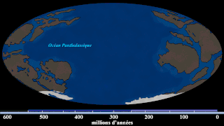
The Cryogenian is a geologic period that lasted from 720 to 635 million years ago. It forms the second geologic period of the Neoproterozoic Era, preceded by the Tonian Period and followed by the Ediacaran.

A flood basalt is the result of a giant volcanic eruption or series of eruptions that covers large stretches of land or the ocean floor with basalt lava. Many flood basalts have been attributed to the onset of a hotspot reaching the surface of the earth via a mantle plume. Flood basalt provinces such as the Deccan Traps of India are often called traps, after the Swedish word trappa, due to the characteristic stairstep geomorphology of many associated landscapes.

A large igneous province (LIP) is an extremely large accumulation of igneous rocks, including intrusive and extrusive, arising when magma travels through the crust towards the surface. The formation of LIPs is variously attributed to mantle plumes or to processes associated with divergent plate tectonics. The formation of some of the LIPs in the past 500 million years coincide in time with mass extinctions and rapid climatic changes, which has led to numerous hypotheses about causal relationships. LIPs are fundamentally different from any other currently active volcanoes or volcanic systems.

Volcanic activity is a major part of the geology of Canada and is characterized by many types of volcanic landform, including lava flows, volcanic plateaus, lava domes, cinder cones, stratovolcanoes, shield volcanoes, submarine volcanoes, calderas, diatremes, and maars, along with less common volcanic forms such as tuyas and subglacial mounds.
The Karoo and Ferrar Large Igneous Provinces (LIPs) are two large igneous provinces in Southern Africa and Antarctica respectively, collectively known as the Karoo-Ferrar, Gondwana, or Southeast African LIP, associated with the initial break-up of the Gondwana supercontinent at c.183Ma. Its flood basalt mostly covers South Africa and Antarctica but portions extend further into southern Africa and into South America, India, Australia and New Zealand.
The High Arctic Large Igneous Province (HALIP) is a Cretaceous large igneous province in the Arctic. The region is divided into several smaller magmatic provinces. Svalbard, Franz Josef Land, Sverdrup Basin, Amerasian Basin, and northern Greenland are some of the larger divisions. Today, HALIP covers an area greater than 1,000,000 km2 (390,000 sq mi), making it one of the largest and most intense magmatic complexes on the planet. However, eroded volcanic sediments in sedimentary strata in Svalbard and Franz Josef Land suggest that an extremely large portion of HALIP volcanics have already been eroded away.
The Marinoan glaciation, sometimes also known as the Varanger glaciation, was a period of worldwide glaciation. Its beginning is poorly constrained, but occurred no earlier than 654.5 Ma. It ended approximately 632.3 ± 5.9 Ma during the Cryogenian period. This glaciation possibly covered the entire planet, in an event called the Snowball Earth. The end of the glaciation was caused by volcanic release of carbon dioxide and dissolution of gas hydrates and might have been hastened by the release of methane from equatorial permafrost.
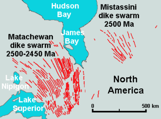
The Matachewan dike swarm is a large 2,500 to 2,450 million year old Paleoproterozoic dike swarm of Northern Ontario, Canada. It consists of basaltic dikes that were intruded in greenschist, granite-greenstone, and metamorphosed sedimentary terrains of the Superior Craton of the Canadian Shield. With an area of 360,000 square kilometres (140,000 sq mi), the Matachewan dike swarm stands as a large igneous province.

Volcanism of Northern Canada has produced hundreds of volcanic areas and extensive lava formations across Northern Canada. The region's different volcano and lava types originate from different tectonic settings and types of volcanic eruptions, ranging from passive lava eruptions to violent explosive eruptions. Northern Canada has a record of very large volumes of magmatic rock called large igneous provinces. They are represented by deep-level plumbing systems consisting of giant dike swarms, sill provinces and layered intrusions.

The Franklin dike swarm, also called the Franklin dikes, is a Proterozoic dike swarm of the Franklin Large Igneous Province in Northern Canada. It is one of the several major magmatic events in the Canadian Shield and it was formed 723 million years ago. Areas in the Franklin have been prospected for nickel, copper, and platinum group metals.
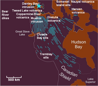
The Mackenzie Large Igneous Province (MLIP) is a major Mesoproterozoic large igneous province of the southwestern, western and northwestern Canadian Shield in Canada. It consists of a group of related igneous rocks that were formed during a massive igneous event starting about 1,270 million years ago. The large igneous province extends from the Arctic in Nunavut to near the Great Lakes in Northwestern Ontario where it meets with the smaller Matachewan dike swarm. Included in the Mackenzie Large Igneous Province are the large Muskox layered intrusion, the Coppermine River flood basalt sequence and the massive northwesterly trending Mackenzie dike swarm.
The Winagami sill complex, also called the Winagami sills, is a Paleoproterozoic large igneous province of northwestern Alberta, Canada. It consists of a series of related sills that were formed between 1.89 and 1.76 billion years ago. The Winagami sill complex covers an area of 120,000 km2 (46,000 sq mi).
The Long Range dikes are a Neoproterozoic mafic dike swarm of Newfoundland and Labrador, Canada. It consists of a large igneous province with an area of 105,000 km2 (41,000 sq mi) that was constructed about 620 million years ago when Laurentia broke-up from Baltica. Its formation might have occurred when the ancient Iapetus Ocean began to open.
The Mistassini dike swarm is a 2.5 billion year old Paleoproterozoic dike swarm of western Quebec, Canada. It consists of mafic dikes that were intruded in the Superior craton of the Canadian Shield. With an area of 100,000 km2 (39,000 sq mi), the Mistassini dike swarm stands as a large igneous province.
The Sturtian glaciation was a worldwide glaciation during the Cryogenian Period when the Earth experienced repeated large-scale glaciations. As of January 2023, the Sturtian glaciation is thought to have lasted from c. 717 Ma to c. 660 Ma, a time span of approximately 57 million years. It is hypothesised to have been be a Snowball Earth event, or contrastingly multiple regional glaciations, and is the longest and most severe known glacial event preserved in the geologic record.
The Skagerrak-Centered Large Igneous Province (SCLIP), also known as the European-Northwest African Large Igneous Province (EUNWA), and Jutland LIP, is a 300 million year old (Ma) large igneous province (LIP) centered on what is today the Skagerrak strait in north-western Europe. It was named by Torsvik et al. 2008.
