High Arctic Large Igneous Province

Last updated
Provinces of the HALIP [1]
Location
(formal name)
Extent
(km2)
Age
(Ma)
Svalbard
(Diabasodden Suite)
750,000124.5
Franz Josef Land 116.5
Barents Sea 15–20,000Unknown
Canadian Arctic Archipelago,
Queen Elizabeth Islands
(Sverdrup Basin Magmatic Province)
550,00090–130
Peary Land, Northern Greenland
(Kap Washington Group)
80,000130–80
Alpha Ridge, Amerasian Basin 200,00097–79
De Long Islands/Bennett Island 228124–109

The High Arctic Large Igneous Province (HALIP) is a Cretaceous large igneous province in the Arctic. The region is divided into several smaller magmatic provinces. Svalbard, Franz Josef Land, Sverdrup Basin, Amerasian Basin, and northern Greenland (Peary Land) are some of the larger divisions. Today, HALIP covers an area greater than 1,000,000 km2 (390,000 sq mi), making it one of the largest and most intense magmatic complexes on the planet. However, eroded volcanic sediments in sedimentary strata in Svalbard and Franz Josef Land suggest that an extremely large portion of HALIP volcanics have already been eroded away. [2]

Contents

Geologic evolution

The HALIP event lasted from 130 million years ago to approximately 60 million years ago. During its active period, there were two distinct phases of volcanism. The first phase lasted from 130 million years ago to 80 million years ago and was characterized by tholeiitic igneous activity. During this time, numerous dikes and sills formed, and there were eruptions of basaltic flow. The basalts formed at this time are relatively rich in TiO2 and have a similar composition to continental flood basalts. The second phase lasted from approximately 85 million years ago to 60 million years ago and was characterized by mildly alkaline igneous activity and the eruption of flood basalts. The igneous rocks formed during the second phase have a similar geochemical makeup as the intra-plate composition. [3]

The Arctic Ocean is a few hundred million years old, making it the youngest ocean on Earth. In the Precambrian, when the Arctic was located south of the Equator, the continent Arctica (or Arctida) filled the gap between the cratons that today surround the Arctic region. Arctica rifted apart in the Late Precambrian (950 Ma) and was reassembled in a new configuration in the Late Paleozoic (255 Ma). [4]

Cape Tegethoff, a basaltic headland of Franz Josef Land Kap tegethoff gross.jpg
Cape Tegethoff, a basaltic headland of Franz Josef Land

During the Jurassic-Cretaceous this second continent, known as Pangea, broke apart, opening the Amerasian Basin and the Arctic Ocean. HALIP dispersed the components of this second continent around the margins of the Arctic Ocean where they are now terranes and microplates embedded into fold belts or overlain by sediments. As the Atlantic and Arctic oceans opened during the Mesozoic and into the Cenozoic, the Arctic Region underwent several stages of rifting, sedimentation, and magmatism. [5]

Dolerites collected from Svalbard and elsewhere in the Arctic are mafic intra-plate tholeiites characteristic of HALIP, which indicated that the LIP formed during the opening of the Arctic Ocean around 148–70 Ma. Seismic and magnetic analyses of the seafloor produced ages of 118–83 Ma. [6]

The HALIP is widely thought to have originated from a mantle plume, and the igneous activity of the province often tracked along a similar path as the Icelandic hotspot. [3]

Magmatic provinces

The HALIP is divided into several magmatic provinces. These provinces are divided by location, igneous rock composition, and the formations present.

Svalbard

In the Svalbard province, the HALIP is expressed as an extensive system of alkaline intrusive doleritic rocks. The intrusions largely appear in the form of sills that can reach thicknesses of 100 m (330 ft) and continuously extend for up to 30 km (19 mi) laterally. The basaltic rocks found in Svalbard have an intra-plate composition and are thought to originate from a source near the Alpha Ridge. The Svalbard province is also closely associated with the Franz Josef Land province (discussed below). [7] The two provinces combined cover an area of approximately 750,000 km2 (290,000 sq mi). [1]

Franz Josef Land

The Franz Josef Land province is closely associated with the Svalbard province. Franz Josef Land is located approximately 300 km (190 mi) east of Svalbard and contains igneous rocks of very similar composition to those of Svalbard. However, the archipelago is scattered with a prominent swarm of southeast trending dikes. Extensive sills and volcanic flows can also be found in the region, as well as a few dikes of other trends. The timing of the Franz Josef Land formations and the Svalbard formations is thought to be nearly identical, furthering the evidence for a large initial plume head model for the HALIP. [8]

Sverdrup Basin

Flood basalt layers exposed in Dragon Cliff on western Axel Heiberg Island, Nunavut, Canada Dragon Cliffs, Nunavut.jpg
Flood basalt layers exposed in Dragon Cliff on western Axel Heiberg Island, Nunavut, Canada

The Sverdrup Basin province spreads across the Canadian Arctic Islands. The region is characterized by the presence of a radiating dike swarm across the Queen Elizabeth Islands that seems to suggest the presence of a mantle plume beneath the Alpha Ridge. This province contains igneous rocks of both tholeiitic and alkaline composition. [9] [10] There are also a respectable number of sills and flood basalts in the province. [8] The flood basalts in the Canadian Arctic Islands are similar to those of the Columbia River flood basalts in the Pacific Northwest of the United States. The Sverdrup Basin Magmatic Province covers an area of 550,000 km2 (210,000 sq mi). [1]

Amerasian Basin

The Amerasian Basin's most prominent feature is the Alpha Ridge – which is thought to be the location of the mantle plume that fed the HALIP. The ridge reaches a height of 2,700 m (8,900 ft) from the seafloor. Also in the region are a few basaltic dikes. [11] The Amerasian Basin extends over 200,000 km2 (77,000 sq mi). [1]

Northern Greenland (Peary Land)

The northern Greenland province, also known as Peary Land, contains three dike swarms. The Nansen Land swarm trends SSE-SE and is the oldest of the swarms. The middle-aged swarm is known as the Erlandsen Swarm and trends SE-ESE. The J. P. Koch Swarm is the youngest of the three and trends eastward. The two younger swarms tend to have igneous rocks of alkaline composition, while the Nansen Land swarm tends to have more tholeiitic composition. [8] The Peary Land province covers an area of over 80,000 km2 (31,000 sq mi). [1]

Barents Sea

The Barents Sea province is characterized by igneous intrusions with much similarity to Svalbard and Franz-Josef Land. This region is well known for being petroleum-rich. The Barents Sea province covers an area of 15,000 to 20,000 km2 (5,800 to 7,700 sq mi). [1]

Climatic impact

The HALIP, along with other large igneous provinces, is thought to have caused global warming that led to the Cenomanian-Turonian extinction event. [12] [13] [14] Late Cretaceous (92–86 Ma) vertebrates, including 2.4 m (7.9 ft) long champsosaurs, a crocodile-like reptile, found in the Canadian Arctic suggests that polar climate was much warmer during the Cretaceous when average annual temperature must have exceeded 14 °C. [15]

The BLIP intrusions could have released perhaps 9,000 Gt (8.9×10¹² long tons; 9.9×10¹² short tons) of carbon from the contact aureoles which could have triggered the Aptian oceanic anoxic event (OAE1a) at 120 Ma. [16]

See also

Related Research Articles

<span class="mw-page-title-main">Siberian Traps</span> Large region of volcanic rock in Russia

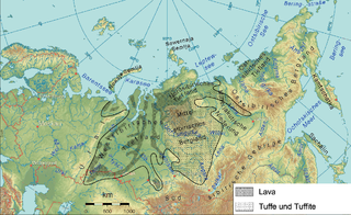
The Siberian Traps is a large region of volcanic rock, known as a large igneous province, in Siberia, Russia. The massive eruptive event that formed the traps is one of the largest known volcanic events in the last 500 million years.

<span class="mw-page-title-main">Flood basalt</span> Very large volume eruption of basalt lava

A flood basalt is the result of a giant volcanic eruption or series of eruptions that covers large stretches of land or the ocean floor with basalt lava. Many flood basalts have been attributed to the onset of a hotspot reaching the surface of the earth via a mantle plume. Flood basalt provinces such as the Deccan Traps of India are often called traps, after the Swedish word trappa, due to the characteristic stairstep geomorphology of many associated landscapes.

<span class="mw-page-title-main">Large igneous province</span> Huge regional accumulation of igneous rocks

A large igneous province (LIP) is an extremely large accumulation of igneous rocks, including intrusive and extrusive, arising when magma travels through the crust towards the surface. The formation of LIPs is variously attributed to mantle plumes or to processes associated with divergent plate tectonics. The formation of some of the LIPs in the past 500 million years coincide in time with mass extinctions and rapid climatic changes, which has led to numerous hypotheses about causal relationships. LIPs are fundamentally different from any other currently active volcanoes or volcanic systems.

<span class="mw-page-title-main">Central Atlantic magmatic province</span> Largest continental igneous province on Earth

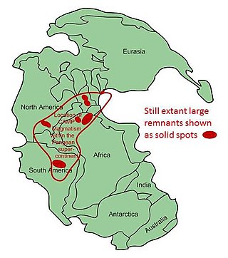
The Central Atlantic magmatic province (CAMP) is the Earth's largest continental large igneous province, covering an area of roughly 11 million km2. It is composed mainly of basalt that formed before Pangaea broke up in the Mesozoic Era, near the end of the Triassic and the beginning of the Jurassic periods. The subsequent breakup of Pangaea created the Atlantic Ocean, but the massive igneous upwelling provided a legacy of basaltic dikes, sills, and lavas now spread over a vast area around the present central North Atlantic Ocean, including large deposits in northwest Africa, southwest Europe, as well as northeast South America and southeast North America. The name and CAMP acronym were proposed by Andrea Marzoli and adopted at a symposium held at the 1999 Spring Meeting of the American Geophysical Union.

The Ontong Java Plateau (OJP) is a massive oceanic plateau located in the southwestern Pacific Ocean, north of the Solomon Islands. The OJP was formed around 116 million years ago (Ma), with a much smaller volcanic event around 90 Ma. Two other southwestern Pacific plateaus, Manihiki and Hikurangi, now separated from the OJP by Cretaceous oceanic basins, are of similar age and composition and probably formed as a single plateau and a contiguous large igneous province together with the OJP. When eruption of lava had finished, the Ontong Java–Manihiki–Hikurangi plateau covered 1% of Earth's surface and represented a volume of 80 million km3 (19 million cu mi) of basaltic magma. This "Ontong Java event", first proposed in 1991, represents the largest volcanic event of the past 200 million years, with a magma eruption rate estimated at up to 22 km3 (5.3 cu mi) per year over 3 million years, several times larger than the Deccan Traps. The smooth surface of the OJP is punctuated by seamounts such as the Ontong Java Atoll, one of the largest atolls in the world.

The Karoo and Ferrar Large Igneous Provinces (LIPs) are two large igneous provinces in Southern Africa and Antarctica respectively, collectively known as the Karoo-Ferrar, Gondwana, or Southeast African LIP, associated with the initial break-up of the Gondwana supercontinent at c.183Ma. Its flood basalt mostly covers South Africa and Antarctica but portions extend further into southern Africa and into South America, India, Australia and New Zealand.

<span class="mw-page-title-main">Amerasia Basin</span> Basin

The Amerasia Basin, or Amerasian Basin, is one of the two major basins from which the Arctic Ocean can be subdivided. The triangular-shaped Amerasia Basin broadly extends from the Canadian Arctic Islands to the East Siberian Sea, and from Alaska to the Lomonosov Ridge. The basin can be further subdivided based on bathymetric features; these include the Canada Basin, the Makarov Basin, the Podvodnikov Basin, the Alpha-Mendeleev Ridge, and the Chukchi Plateau.

<span class="mw-page-title-main">Dike swarm</span> Large geological structure consisting parallel, linear, or radially oriented magmatic dikes

A dike swarm or dyke swarm is a large geological structure consisting of a major group of parallel, linear, or radially oriented magmatic dikes intruded within continental crust or central volcanoes in rift zones. Examples exist in Iceland and near other large volcanoes, around the world. They consist of several to hundreds of dikes emplaced more or less contemporaneously during a single intrusive event, are magmatic and stratigraphic, and may form a large igneous province.

<span class="mw-page-title-main">North Atlantic Igneous Province</span> Large igneous province in the North Atlantic, centered on Iceland

The North Atlantic Igneous Province (NAIP) is a large igneous province in the North Atlantic, centered on Iceland. In the Paleogene, the province formed the Thulean Plateau, a large basaltic lava plain, which extended over at least 1.3 million km2 (500 thousand sq mi) in area and 6.6 million km3 (1.6 million cu mi) in volume. The plateau was broken up during the opening of the North Atlantic Ocean leaving remnants preserved in north Ireland, west Scotland, the Faroe Islands, northwest Iceland, east Greenland, western Norway and many of the islands located in the north eastern portion of the North Atlantic Ocean. The igneous province is the origin of the Giant's Causeway and Fingal's Cave. The province is also known as Brito–Arctic province and the portion of the province in the British Isles is also called the British Tertiary Volcanic Province or British Tertiary Igneous Province.

<span class="mw-page-title-main">Sverdrup Basin Magmatic Province</span> A large igneous province in the Arctic

The Sverdrup Basin Magmatic Province is a large igneous province located on Axel Heiberg Island and Ellesmere Island, Nunavut, Canada near the rifted margin of the Arctic Ocean at the end of Alpha Ridge.

<span class="mw-page-title-main">Circum-Superior Belt</span>

The Circum-Superior Belt is a widespread Paleoproterozoic large igneous province in the Canadian Shield of Northern, Western and Eastern Canada. It extends more than 3,400 km (2,100 mi) from northeastern Manitoba through northwestern Ontario, southern Nunavut to northern Quebec and into western Labrador. Igneous rocks of the Circum-Superior Belt are mafic-ultramafic in composition, deposited in the Labrador Trough near Ungava Bay, the Cape Smith Belt near the southern shore of Hudson Strait and along the eastern shore of Hudson Bay in its northern portion; the Thompson and Fox River belts in the northwest and the Marquette Range Supergroup in its southern portion. The Circum Superior Belt also hosts a rare example of Proterozoic Komatiite, in the Winnipegosis komatiite belt.

<span class="mw-page-title-main">Volcanism of Northern Canada</span> History of volcanic activity in Northern Canada

Volcanism of Northern Canada has produced hundreds of volcanic areas and extensive lava formations across Northern Canada. The region's different volcano and lava types originate from different tectonic settings and types of volcanic eruptions, ranging from passive lava eruptions to violent explosive eruptions. Northern Canada has a record of very large volumes of magmatic rock called large igneous provinces. They are represented by deep-level plumbing systems consisting of giant dike swarms, sill provinces and layered intrusions.

<span class="mw-page-title-main">Mackenzie Large Igneous Province</span>

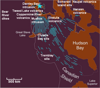
The Mackenzie Large Igneous Province (MLIP) is a major Mesoproterozoic large igneous province of the southwestern, western and northwestern Canadian Shield in Canada. It consists of a group of related igneous rocks that were formed during a massive igneous event starting about 1,270 million years ago. The large igneous province extends from the Arctic in Nunavut to near the Great Lakes in Northwestern Ontario where it meets with the smaller Matachewan dike swarm. Included in the Mackenzie Large Igneous Province are the large Muskox layered intrusion, the Coppermine River flood basalt sequence and the massive northwesterly trending Mackenzie dike swarm.

The Long Range dikes are a Neoproterozoic mafic dike swarm of Newfoundland and Labrador, Canada. It consists of a large igneous province with an area of 105,000 km2 (41,000 sq mi) that was constructed about 620 million years ago when Laurentia broke-up from Baltica. Its formation might have occurred when the ancient Iapetus Ocean began to open.

<span class="mw-page-title-main">Barents Sea dike swarm</span>

Barents Sea dike swarm consists of two groups of dolerite dikes across the Svalbard and Franz Josef Land regions. The emplacement of dikes was associated with the Cretaceous High Arctic Large Igneous Province (HALIP).

<span class="mw-page-title-main">Drakensberg Group</span> Jurassic geological group in Lesotho and South Africa

The Drakensberg Group is a geological group named after the Drakensberg mountain range where in its uppermost sections the rocks are found. The Drakensberg Group lies over most of Lesotho and localities in the Eastern Cape, KwaZulu-Natal, and Free State provinces of South Africa. It forms part of the greater Karoo Igneous Province, which occurs over an extensive area of southern Africa.

<span class="mw-page-title-main">Canadian Arctic Rift System</span> North American geological structure

The Canadian Arctic Rift System is a major North American geological structure extending from the Labrador Sea in the southeast through Davis Strait, Baffin Bay and the Arctic Archipelago in the northwest. It consists of a series of interconnected rifts that formed during the Paleozoic, Mesozoic and Cenozoic eras. Extensional stresses along the entire length of the rift system have resulted in a variety of tectonic features, including grabens, half-grabens, basins and faults.

The Central Iapetus magmatic province (CIMP) was a large igneous province (LIP) that occurred during the Ediacaran between several ancient continents – Laurentia and Baltica and, possibly, Amazonia – during the break-up of the supercontinent Rodinia and resulted in the opening of the Iapetus Ocean.

<span class="mw-page-title-main">Madagascar flood basalt</span>

The Madagascar flood basalt, also known as the Madagascar large igneous province (LIP), is one of the major magmatic events of the Late Cretaceous. They cover a large area of basaltic and rhyolitic lava flows that erupted during an episode of widespread basaltic volcanism during the Cretaceous period. The flood basalts are characterized by lava flows, dykes, sills, and intrusions, and other volcanic features include plugs, scoria, and spatter cones. Tholeiitic basalt constitutes the primary rock type.

The Equatorial Atlantic Magmatic Province (EQUAMP) is a Cretaceous large igneous province (LIP) in South America covering 700,000 km2 (270,000 sq mi). The break-up of the supercontinent Gondwana resulted in a series of large volcanic eruptions, but EQUAMP is the only Gondwanan LIP composed exclusively of intrusive rock, making it a Large Plutonic Province (LPP).

References

Notes

  1. 1 2 3 4 5 6 Senger et al. 2014 , Table 5, p. 137
  2. Døssing et al. 2013 , Abstract
  3. 1 2 Jowitt, S. M.; Williamson, M.-C.; Ernst, R. E. (1 March 2014). "Geochemistry of the 130 to 80 Ma Canadian High Arctic Large Igneous Province (HALIP) Event and Implications for Ni-Cu-PGE Prospectivity". Economic Geology . 109 (2): 281–307. Bibcode:2014EcGeo.109..281J. doi:10.2113/econgeo.109.2.281. ISSN   0361-0128 . Retrieved 6 September 2023.
  4. Vernikovsky & Dobretsov 2015 , pp. 206–208; fig. 2, p. 208
  5. Corfu et al. 2013 , Introduction, pp. 1127–1128
  6. Nejbert et al. 2011 , Discussion and conclusions, pp. 16, 20
  7. Maher, H. D. Jr. (2001). "Manifestations of the Cretaceous high Arctic large igneous province in Svalbard" (PDF). The Journal of Geology. 109 (1): 91–104. Bibcode:2001JG....109...91M. doi:10.1086/317960. S2CID   225042909.
  8. 1 2 3 "April 2006 LIP of the Month | Large Igneous Provinces Commission". www.largeigneousprovinces.org. Retrieved 2016-05-05.
  9. Bédard, Jean H; Saumur, Benoît-Michel; Tegner, Christian; Troll, Valentin R; Deegan, Frances M; Evenchick, Carol A; Grasby, Stephen E; Dewing, Keith (9 June 2021). "Geochemical systematics of High Arctic Large Igneous Province continental tholeiites from Canada – Evidence for progressive crustal contamination in the plumbing system". Journal of Petrology . 62 (egab041). doi: 10.1093/petrology/egab041 . ISSN   0022-3530 . Retrieved 6 September 2023.
  10. Bédard, Jean H.; Troll, Valentin R.; Deegan, Frances M.; Tegner, Christian; Saumur, Benoit M.; Evenchick, Carol A.; Grasby, Stephen E.; Dewing, Keith (9 June 2021). "High Arctic Large Igneous Province Alkaline Rocks in Canada: Evidence for Multiple Mantle Components". Journal of Petrology . 62 (egab042): 1–31. doi: 10.1093/petrology/egab042 . ISSN   0022-3530 . Retrieved 6 September 2023.
  11. Døssing et al. 2013.
  12. Schröder-Adams, Claudia J.; Herrle, Jens O.; Selby, David; Quesnel, Alex; Froude, Gregory (1 April 2019). "Influence of the High Arctic Igneous Province on the Cenomanian/Turonian boundary interval, Sverdrup Basin, High Canadian Arctic". Earth and Planetary Science Letters . 511: 76–88. Bibcode:2019E&PSL.511...76S. doi:10.1016/j.epsl.2019.01.023. S2CID   133942033 . Retrieved 22 April 2023.
  13. Naber, T.V.; Grasby, S.E.; Cuthbertson, J.P.; Rayner, N.; Tegner, C. (16 December 2020). "New constraints on the age, geochemistry, and environmental impact of High Arctic Large Igneous Province magmatism: Tracing the extension of the Alpha Ridge onto Ellesmere Island, Canada". Geological Society of America Bulletin . 133 (7–8): 1695–1711. doi:10.1130/B35792.1. ISSN   0016-7606 . Retrieved 12 September 2023.
  14. Davis, William J.; Schröder-Adams, Claudia J.; Galloway, Jennifer M.; Herrle, Jens O.; Pugh, Adam T. (24 June 2016). "U–Pb geochronology of bentonites from the Upper Cretaceous Kanguk Formation, Sverdrup Basin, Arctic Canada: constraints on sedimentation rates, biostratigraphic correlations and the late magmatic history of the High Arctic Large Igneous Province". Geological Magazine . 154 (4): 757–776. doi:10.1017/S0016756816000376. ISSN   0016-7568 . Retrieved 12 September 2023.
  15. Tarduno et al. 1998b , Abstract; Fig. 4, p. 2243
  16. Polteau et al. 2010 , Abstract

Sources

79°26′56″N11°23′44″E / 79.4488°N 11.3955°E / 79.4488; 11.3955