
Kimberlite is an igneous rock, which sometimes contains diamonds. It is named after the town of Kimberley in South Africa, where the discovery of an 83.5-carat (16.70 g) diamond called the Star of South Africa in 1869 spawned a diamond rush and the digging of the open-pit mine called the Big Hole. Previously, the term kimberlite has been applied to olivine lamproites as Kimberlite II, however this has been in error.

Weloganite is a rare carbonate mineral with formula: Na2(Sr,Ca)3Zr(CO3)6·3H2O. It was discovered by Canadian government mineralogist Ann P. Sabina in 1967 and named for Canadian geologist Sir William Edmond Logan (1798–1875). It was first discovered in Francon Quarry, Montreal, Quebec, Canada and has only been reported from a few localities worldwide.

Diabase or dolerite or microgabbro is a mafic, holocrystalline, subvolcanic rock equivalent to volcanic basalt or plutonic gabbro. Diabase dikes and sills are typically shallow intrusive bodies and often exhibit fine grained to aphanitic chilled margins which may contain tachylite. Diabase is the preferred name in North America, yet dolerite is the preferred name in most of the rest of the world, where sometimes the name diabase is applied to altered dolerites and basalts. Many petrologists prefer the name microgabbro to avoid this confusion.
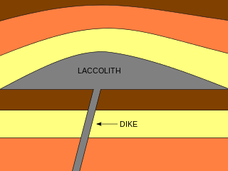
A laccolith is a sheet intrusion that has been injected between two layers of sedimentary rock. The pressure of the magma is high enough that the overlying strata are forced upward, giving the laccolith a dome or mushroom-like form with a generally planar base.

In geology, a sill is a tabular sheet intrusion that has intruded between older layers of sedimentary rock, beds of volcanic lava or tuff, or along the direction of foliation in metamorphic rock. A sill is a concordant intrusive sheet, meaning that a sill does not cut across preexisting rock beds. Stacking of sills builds a sill complex and a large magma chamber at high magma flux. In contrast, a dike is a discordant intrusive sheet, which does cut across older rocks. Sills are fed by dikes, except in unusual locations where they form in nearly vertical beds attached directly to a magma source. The rocks must be brittle and fracture to create the planes along which the magma intrudes the parent rock bodies, whether this occurs along preexisting planes between sedimentary or volcanic beds or weakened planes related to foliation in metamorphic rock. These planes or weakened areas allow the intrusion of a thin sheet-like body of magma paralleling the existing bedding planes, concordant fracture zone, or foliations.

Carbonatite is a type of intrusive or extrusive igneous rock defined by mineralogic composition consisting of greater than 50% carbonate minerals. Carbonatites may be confused with marble and may require geochemical verification.

A layered intrusion is a large sill-like body of igneous rock which exhibits vertical layering or differences in composition and texture. These intrusions can be many kilometres in area covering from around 100 km2 (39 sq mi) to over 50,000 km2 (19,000 sq mi) and several hundred metres to over one kilometre (3,300 ft) in thickness. While most layered intrusions are Archean to Proterozoic in age, they may be any age such as the Cenozoic Skaergaard intrusion of east Greenland or the Rum layered intrusion in Scotland. Although most are ultramafic to mafic in composition, the Ilimaussaq intrusive complex of Greenland is an alkalic intrusion.

Volcanology of Canada includes lava flows, lava plateaus, lava domes, cinder cones, stratovolcanoes, shield volcanoes, submarine volcanoes, calderas, diatremes, and maars, along with examples of more less common volcanic forms such as tuyas and subglacial mounds. It has a very complex volcanological history spanning from the Precambrian eon at least 3.11 billion years ago when this part of the North American continent began to form.
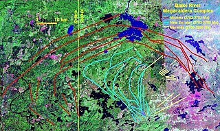
The New Senator Caldera is a large Archean caldera complex within the heart of the Blake River Megacaldera Complex, Quebec, Canada. It has a diameter of 15-30 kilometers and is made of thick massive mafic sequences. The caldera complex has inferred to be a subaqueous lava lake during the early stages of the caldera's development. Gabbro sills represent lava lakes, which are common in mafic summit calderas. These subaqueous lava lakes are large units with a change in grain size from coarse to fine grained and a hyaloclastite top. The Kiwanis (Norands) intrusion, a high-level synvolcanic magma chamber, intrudes felsic rocks, and is in turn cross-cut by basaltic dikes and sills.
The High Arctic Large Igneous Province (HALIP) is a Cretaceous large igneous province in the Arctic. The region is divided into several smaller magmatic provinces. Svalbard, Franz Josef Land, Sverdrup Basin, Amerasian Basin, and northern Greenland are some of the larger divisions. Today, HALIP covers an area greater than 1,000,000 km2 (390,000 sq mi), making it one of the largest and most intense magmatic complexes on the planet. However, eroded volcanic sediments in sedimentary strata in Svalbard and Franz Josef Land suggest that an extremely large portion of HALIP volcanics have already been eroded away.
The Bravo Lake Formation is a mafic volcanic belt and large igneous province located at the northern margin of the Trans-Hudson orogeny on central Baffin Island, Nunavut, Canada. It is exposed along a nearly continuous east-west passage for 120 km (75 mi) and changes in stratigraphic thickness from 1 to 2.5 kilometers. The formation is a rare alkaline-suite that formed as a result of submarine rifting during the Paleoproterozoic period. The Bravo Lake Formation is surprisingly undeformed by the Himalayan-scale forming event during the Trans-Hudsonian orogeny.

The Sverdrup Basin Magmatic Province is a large igneous province located on Axel Heiberg Island and Ellesmere Island, Nunavut, Canada near the rifted margin of the Arctic Ocean at the end of Alpha Ridge.

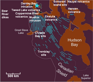
The Muskox intrusion is a layered intrusion in Nunavut, Canada. It is located 144 km (89 mi) northeast of Great Bear Lake and 90 km (56 mi) south of Kugluktuk on Coronation Gulf. It was formed during a large magmatic event during the Proterozoic by hotspot or mantle plume volcanism that emplaced the widespread Coppermine River Group flood basalts.
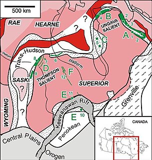
The Circum-Superior Belt is a widespread Paleoproterozoic large igneous province in the Canadian Shield of Northern, Western and Eastern Canada. It extends more than 3,400 km (2,100 mi) from northeastern Manitoba through northwestern Ontario, southern Nunavut to northern Quebec. Igneous rocks of the Circum-Superior Belt are mafic-ultramafic in composition, deposited in the Labrador Trough near Ungava Bay, the Cape Smith Belt near the southern shore of Hudson Strait and along the eastern shore of Hudson Bay in its northern portion; the Thompson and Fox River belts in the northwest and the Marquette Range Supergroup in its southern portion.

Volcanology of Northern Canada includes hundreds of volcanic areas and extensive lava formations across Northern Canada. The region's different volcano and lava types originate from different tectonic settings and types of volcanic eruptions, ranging from passive lava eruptions to violent explosive eruptions. Northern Canada has a record of very large volumes of magmatic rock called large igneous provinces. They are represented by deep-level plumbing systems consisting of giant dike swarms, sill provinces and layered intrusions.

The Franklin Large Igneous Province is a Neoproterozoic large igneous province in the Canadian Arctic of Northern Canada. It represents one of the largest large igneous provinces in Canada, consisting of the Natkusiak flood basalts on Victoria Island, the Coronation sills on the southern shore of the Coronation Gulf and the large Franklin dike swarm, which extends for more than 1,200 km (750 mi) across the Canadian Arctic Archipelago and northwestern Greenland. The Franklin Large Igneous Province covers an area of more than 1,100,000 km2 (420,000 sq mi).
The Mackenzie Large Igneous Province (MLIP) is a major Mesoproterozoic large igneous province of the southwestern, western and northwestern Canadian Shield in Canada. It consists of a group of related igneous rocks that were formed during a massive igneous event starting about 1,270 million years ago. The large igneous province extends from the Arctic in Nunavut to near the Great Lakes in Northwestern Ontario where it meets with the smaller Matachewan dike swarm. Included in the Mackenzie Large Igneous Province are the large Muskox layered intrusion, the Coppermine River flood basalt sequence and the massive northwesterly trending Mackenzie dike swarm.
A sill swarm or sill complex in geology is a major group of sills intruded within continental crust. They are located under volcanic edifices, including flood basalt provinces and large lava plateaus. The volume of sill swarms can be similar to dike swarms.

The Ungava magmatic event was a widespread magmatic event that began about 2.22 billion years ago during the Proterozoic Eon.

