Antarctic Circumpolar Current (ACC) is an ocean current that flows clockwise from west to east around Antarctica. An alternative name for the ACC is the West Wind Drift. The ACC is the dominant circulation feature of the Southern Ocean and has a mean transport estimated at 100–150 Sverdrups, or possibly even higher, making it the largest ocean current. The current is circumpolar due to the lack of any landmass connecting with Antarctica and this keeps warm ocean waters away from Antarctica, enabling that continent to maintain its huge ice sheet.

The Drake Passage is the body of water between South America's Cape Horn, Chile, Argentina, and the South Shetland Islands of Antarctica. It connects the southwestern part of the Atlantic Ocean with the southeastern part of the Pacific Ocean and extends into the Southern Ocean. The passage is named after the 16th-century English explorer and privateer Sir Francis Drake.

In oceanography, a gyre is any large system of ocean surface currents moving in a circular fashion driven by wind movements. Gyres are caused by the Coriolis effect; planetary vorticity, horizontal friction and vertical friction determine the circulatory patterns from the wind stress curl (torque).

The Scotia plate is a minor tectonic plate on the edge of the South Atlantic and Southern oceans. Thought to have formed during the early Eocene with the opening of the Drake Passage that separates Antarctica and South America, it is a minor plate whose movement is largely controlled by the two major plates that surround it: the Antarctic plate and the South American plate. The Scotia plate takes its name from the steam yacht Scotia of the Scottish National Antarctic Expedition (1902–04), the expedition that made the first bathymetric study of the region.

The Kerguelen Plateau, also known as the Kerguelen–Heard Plateau, is an oceanic plateau and large igneous province (LIP) located on the Antarctic Plate, in the southern Indian Ocean. It is about 3,000 km (1,900 mi) to the southwest of Australia and is nearly three times the size of California. The plateau extends for more than 2,200 km (1,400 mi) in a northwest–southeast direction and lies in deep water.
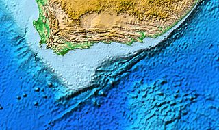
The Agulhas Bank is a broad, shallow part of the southern African continental shelf which extends up to 250 km (160 mi) south of Cape Agulhas before falling steeply to the abyssal plain.

The Antarctic bottom water (AABW) is a type of water mass in the Southern Ocean surrounding Antarctica with temperatures ranging from −0.8 to 2 °C (35 °F) and absolute salinities from 34.6 to 35.0 g/kg. As the densest water mass of the oceans, AABW is found to occupy the depth range below 4000 m of all ocean basins that have a connection to the Southern Ocean at that level. AABW forms the lower branch of the large-scale movement in the world's oceans through thermohaline circulation.

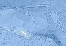
The Campbell Plateau is a large oceanic plateau south of New Zealand and the Chatham Rise. It originated in the Gondwanan breakup and is part of Zealandia, a largely submerged continent. The above sea level parts of the plateau — the Bounty Islands, Antipodes Islands, Auckland Islands and Campbell Island — form part of the New Zealand Subantarctic Islands which were declared a World Heritage Site in 1998. Large parts of the Campbell Plateau lie less than 1000 m below sea level. It rises to 500 m at the Pukaki Rise and emerges above sea level at the Auckland and Campbell Islands.

The Scotia Arc is the island arc system forming the north, east and south border of the Scotia Sea. The northern border, the North Scotia Ridge, comprises : Isla de los Estados at the tip of Tierra del Fuego, the Burdwood, Davis, and Aurora Banks; the Shag, South Georgia Island and Clerke Rocks. The eastern border comprises the volcanic South Sandwich Islands flanked by the South Sandwich Trench. The southern border, the South Scotia Ridge, comprises : Herdman, Discovery, Bruce, Pirie, and Jane Banks; the South Orkney Islands and Elephant Island. Finally, the Bransfield Strait separates the arc from the South Shetland Islands and James Ross Island flanking the tip of the Antarctic Peninsula.

The South American–Antarctic Ridge or simply American-Antarctic Ridge is the tectonic spreading center between the South American plate and the Antarctic plate. It runs along the sea-floor from the Bouvet triple junction in the South Atlantic Ocean south-westward to a major transform fault boundary east of the South Sandwich Islands. Near the Bouvet triple junction the spreading half rate is 9 mm/a (0.35 in/year), which is slow, and the SAAR has the rough topography characteristic of slow-spreading ridges.

The Weddell Gyre is one of the two gyres that exist within the Southern Ocean. The gyre is formed by interactions between the Antarctic Circumpolar Current (ACC) and the Antarctic Continental Shelf. The gyre is located in the Weddell Sea, and rotates clockwise. South of the ACC and spreading northeast from the Antarctic Peninsula, the gyre is an extended large cyclone. Where the northeastern end ends at 30°E, which is marked by the southward turn of the ACC, the northern part of the gyre spreads over the Southern Scotia Sea and goes northward to the South Sandwich Arc. Axis of the gyre is over the southern flanks of the South Scotia, America-Antarctic, and Southwest Indian Ridges. In the southern part of the gyre, the westward return flow is about 66 sverdrup (Sv), while in the northern rim current, there is an eastward flow of 61 Sv.

The Ross Gyre is one of three gyres that exists within the Southern Ocean around Antarctica, the others being the Weddell Gyre and Balleny Gyre. The Ross Gyre is located north of the Ross Sea, and rotates clockwise. The gyre is formed by interactions between the Antarctic Circumpolar Current and the Antarctic Continental Shelf. The Ross Gyre is bounded by the Polar Front of the Antarctic Circumpolar Current to the north, the Antarctic Slope Current to the south, the Balleny Gyre to the west, and a variable boundary to the east from semiannual changes in sea surface height (SSH) in the Amundsen Sea. Circulation in the Ross Gyre has been estimated to be 20 ± 5 Sverdrup (Sv) and plays a large role in heat exchange in this region.

Gondwana was a large landmass, sometimes referred to as a supercontinent. The remnants of Gondwana make up around two-thirds of today's continental area, including South America, Africa, Antarctica, Australia, Zealandia, Arabia, and the Indian Subcontinent.

The Shona or Meteor hotspot is a volcanic hotspot located in the southern Atlantic Ocean. Its zig-zag-shaped hotspot track, a chain of seamounts and ridges, stretches from its current location at or near the southern end of the Mid-Atlantic Ridge to South Africa.
The Maud Rise is an oceanic plateau, which rises, at its shallowest, to depths of about 1,000 meters. It is located in the Weddell Sea in the Southern Ocean. Its name was approved by the Advisory Committee for Undersea Features in June 1987.

The Rio Grande Rise, also called the Rio Grande Elevation or Bromley Plateau, is an aseismic ocean ridge in the southern Atlantic Ocean off the coast of Brazil. Together with the Walvis Ridge off Africa, the Rio Grande Rise forms a V-shaped structure of mirrored hotspot tracks or seamount chains across the northern South Atlantic. In 2013, Brazilian scientists announced that they found granite boulders on the Rio Grande Rise and speculated that it could be the remains of a submerged continent, which they called the "Brazilian Atlantis". Other researchers, however, noted that such boulders can end-up on the ocean floor by less speculative means.

The Agulhas Plateau is an oceanic plateau located in the south-western Indian Ocean about 500 km (310 mi) south of South Africa. It is a remainder of a large igneous province (LIP), the Southeast African LIP, that formed 140 to 95 million years ago (Ma) at or near the triple junction where Gondwana broke-up into Antarctica, South America, and Africa. The plateau formed 100 to 94 Ma together with Northeast Georgia Rise and Maud Rise when the region passed over the Bouvet hotspot.

The Agulhas Basin is an oceanic basin located south of South Africa where the South Atlantic Ocean and south-western Indian Ocean meet. Part of the African plate, it is bounded by the Agulhas Ridge to the north and the Southwest Indian Ridge to the south; by the Meteor Rise to the west and the Agulhas Plateau to the east. Numerous bathymetric anomalies hint at the basin's dynamic tectonic history.
The Agulhas Passage is an abyssal channel located south of South Africa between the Agulhas Bank and Agulhas Plateau. About 50 km (31 mi) wide, it connects the Natal Valley and Transkei Basin in the north to the Agulhas Basin in the south and is the only near-shore connection between the south-western Indian Ocean and South Atlantic Ocean.