Heanor (/ˈhiːnə/) is a town in the Amber Valley district of Derbyshire in the East Midlands of England. It lies 8 miles (13 km) north-east of Derby and forms, with the adjacent village of Loscoe, the civil parish and town council-administered area of Heanor and Loscoe, which had a population of 17,251 in the 2011 census.

Worminghall is a village and civil parish in the Buckinghamshire district of the ceremonial county of Buckinghamshire, England.

Markeaton is a suburban village within Derby in the East Midlands of England. It is in the Mackworth Ward of Derby City Council.
Allestree is a suburb and ward of the city of Derby, a unitary authority area, in Derbyshire, England. It is the northernmost ward and is situated on the A6 road, about 2 miles (3 km) north of Derby city centre. It is bordered by the district of Amber Valley along its western and northern edges and Erewash in its north-east corner. To the south it borders the ward of Mackworth and to the east the ward of Darley Abbey.

Mackworth is a suburb and electoral ward of the city of Derby, England. Is it located on the north-west of the city near to Markeaton Park and the suburb of Mickleover. It is also known as Mackworth Estate, to distinguish it from the nearby Mackworth village. The Mackworth ward also covers the New Zealand area as well as Mackworth itself.

Weston Longville is a civil parish in the English county of Norfolk, approximately 8 miles (13 km) north-west of Norwich. Its name is derived from the Manor of Longaville in Normandy, France, which owned the local land in the 12th century. It covers an area of 11.24 km2 (4.34 sq mi) and had a population of 303 in 127 households at the 2001 census, increasing to a population of 339 in 144 households at the 2011 Census. For the purposes of local government, it falls within the district of Broadland.

Buckden is a village and civil parish 3.7 miles (6.0 km) north of St Neots and 4 miles (6.4 km) south-west of Huntingdon, England. It includes the hamlets of Stirtloe and Hardwick. It lies in Huntingdonshire, a non-metropolitan district of Cambridgeshire and a historic county, close to three transport routes of past and present: the River Great Ouse, along its eastern boundary, the Great North Road that once crossed the village, but now bypasses it to the west, and the East Coast Mainline along the eastern side of the Great Ouse valley in the neighbouring parish of The Offords.

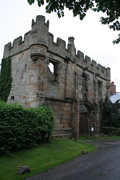
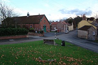
Kedleston is a village and civil parish in the Amber Valley district of Derbyshire, approximately 4 miles (6.4 km) north-west of Derby. Nearby places include Quarndon, Weston Underwood, Mugginton and Kirk Langley. The population at the 2011 Census was less than 100. Details are included in the civil parish of Mackworth, Amber Valley.

Almeley is a village and civil parish in Herefordshire, England. The civil parish includes the hamlets of Almeley Wooton and Upcott. The 2011 Census recorded the parish's population as 601.

Aston Rowant is a village, civil parish and former manor about 4+1⁄2 miles (7 km) south of Thame in South Oxfordshire, England. The parish includes the villages of Aston Rowant and Kingston Blount, and adjoins Buckinghamshire to the southeast. The 2011 Census recorded the parish's population as 793. The Lower Icknield Way passes through the parish southeast of the village.

Trotton with Chithurst is a civil parish in the Chichester district of West Sussex, England. Trotton is on the A272 road 7 miles (11 km) west of Midhurst. Chithurst is about 1 mile (1.6 km) north west of Trotton. The parish also contains the hamlet of Dumpford.

Breaston is a large village and civil parish in the Erewash district, in the south-east of Derbyshire and lies approximately 6.81 miles (10.96 km) east of the city of Derby and 8 miles (13 km) west of the city of Nottingham. The population of the civil parish as taken at the 2011 Census was 4,455. The settlement name Breaston means 'Braegd's farm/settlement': for a personal name and 'tūn' for either an enclosure, farmstead, village, etc.

Green Hammerton is a village and civil parish in the Harrogate district of North Yorkshire, England. It is situated on the A59 road, 8 miles (13 km) west of York and 10 miles (16 km) east of Harrogate. Along with nearby Kirk Hammerton, the village is served by Hammerton railway station on the Harrogate line.
Whixley is a village and civil parish in the Harrogate district of North Yorkshire, England. It is near the A1(M) motorway and 10 miles (16 km) west of York. The ancient village of Whixley lies on Rudgate, the old Roman road along which the Roman “Hispania” Legion would have marched to nearby Isurium (Aldborough).

Swine is a village and civil parish in the East Riding of Yorkshire, England. It is situated approximately 5 miles (8 km) north-east of Hull city centre and 2 miles (3.2 km) south of Skirlaugh to the west of the A165 road.
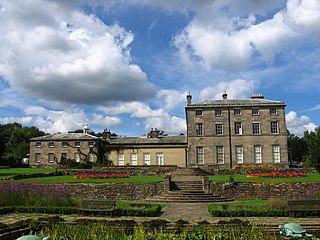
William Emes was an English landscape gardener.

Swyncombe is a hamlet and large civil parish in the high Chilterns, within the Area of Outstanding Natural Beauty about 4+1⁄2 miles (7 km) east of Wallingford, Oxfordshire, England. Swyncombe hamlet consists almost entirely of its Church of England parish church of Saint Botolph, the former rectory and Swyncombe House. The population of the parish is in the hamlets of Cookley Green and Russell's Water, and the scattered hamlet of Park Corner. The 2011 Census recorded the parish's population as 250. It is partially forested and is the fifth largest of 87 civil parishes in the District.

Culmington is a village and civil parish in south Shropshire, England, about 3+1⁄2 miles (5.6 km) east of Craven Arms and 4+1⁄2 miles (7 km) north of Ludlow. The village is about 330 feet (100 m) above sea level, beside the River Corve, just east of the B4365 road. The 2011 Census recorded the parish population as 423.

Newton Kyme is a village in the civil parish of Newton Kyme cum Toulston near the River Wharfe, in the Selby district, in the English county of North Yorkshire. The population of the civil parish at the 2011 Census was 275. It is near the town of Tadcaster. For transport there is the A659 road nearby. Newton Kyme has a church and a castle called Kyme Castle.

The Markeaton Brook is an 11-mile-long (17 km) tributary of the River Derwent in Derbyshire, England. The brook rises from its source south of Hulland Ward, and flows for most of its length through the countryside north-west of Derby before entering a culvert to the north of the city centre; it reappears from this culvert and runs through a short section of open channel on the other side of the city before joining the Derwent.