Mackworth, Derby

Last updated

Mackworth
Mackworth Estate, Derby.jpg
Road sign approaching Mackworth on the A52
Derbyshire UK location map.svg
Red pog.svg
Mackworth
Location within Derbyshire
Population14,180 (2011 Census)
OS grid reference SK323368
Unitary authority
Ceremonial county
Region
Country England
Sovereign state United Kingdom
Post town DERBY
Postcode district DE22
Dialling code 01332
Police Derbyshire
Fire Derbyshire
Ambulance East Midlands
EU Parliament East Midlands
UK Parliament
List of places
UK
England
Derbyshire
52°55′40″N1°32′14″W / 52.92771°N 1.53733°W / 52.92771; -1.53733 Coordinates: 52°55′40″N1°32′14″W / 52.92771°N 1.53733°W / 52.92771; -1.53733

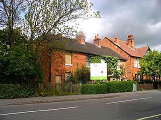
Mackworth is a suburb and electoral ward of the city of Derby, England. Is it located on the north-west of the city near to Markeaton Park and the suburb of Mickleover. It is also known as Mackworth Estate, to distinguish it from the nearby Mackworth village. The Mackworth ward also covers the New Zealand area as well as Mackworth itself.

Derby City and Unitary authority area

Derby is a city and unitary authority area in Derbyshire, England. It lies on the banks of the River Derwent in the south of Derbyshire, of which it was traditionally the county town. At the 2011 census, the population was 248,700. Derby gained city status in 1977.

Markeaton Park

Markeaton Park is a large public park located in Markeaton, Derby, 207 acres in size. It attracts one million visitors a year, making it one of the most visited parks in the East Midlands. Markeaton Park is an important part of Derby history, which was sold to the Mundy family in 1516. The Mundy family gave Markeaton Park to Derby City Council in the early 20th century who now provide facilities and events throughout the year.

Mickleover human settlement in United Kingdom

Mickleover is the most westerly suburb of the city of Derby in the United Kingdom. It is located 2 miles (3.2 km) west of the city centre.

Contents

History

Development as a housing estate began in the 1930s, with construction on Brackensdale Avenue, Greenland Avenue, Lilac Avenue and Laburnum Grove. Most of the area was developed during the 1950s (the first house completed in 1953) and it was one of the largest housing estates to be built in the city. Further development followed on the northern fringes of the estate, with sporadic small building projects over the years that followed. Mackworth's most noticeable landmark ( SK312368 ) is a large water tower owned by Severn Trent and can be seen from much of the estate. The estate was home to Derby College, Prince Charles Avenue Campus. These buildings were formerly Mackworth Secondary School and Parkfields Cedars Grammar School for Girls, subsequently combined to form Parkfields Comprehensive School, which closed in the 1980s, the building then being turned over to the local tertiary college. Once education on the site ceased further housing was built in the 2010s.

Severn Trent company

Severn Trent plc is a water company based in the United Kingdom that is traded on the London Stock Exchange and is a constituent of the FTSE 100 Index. Severn Trent, the trading name owned by the company, applies to a group of companies employing more than 15,000 people across the United Kingdom, United States and mainland Europe, with some involvement in the Middle East.

Derby College Fe college in Derby, Derbyshire, England

Derby College is a further education centre with sites located within Derbyshire. It delivers training in workplace locations across England.

Today the majority of homes on the estate are now owner occupied, though there is still a significant stock of social housing available. Housing density is very low, there are plentiful areas of green open space, and there is very little terraced/apartment housing. There are a number of small bungalows originally designed for older residents, some on the same site as an old people's home along with residential provision for people with vision impairment (The Lois Ellis Home for the Blind). Following closure of local authority provision, these residential facilities were demolished and subsequently an Extra Care Facility was built on the site. Amenities and facilities for local residents include shops, dentist, doctors, churches etc. A branch of the city library opened in late March 2010.

During development in the 1950s all but one (the exception being the main artery of the Estate, Prince Charles Avenue) of the roads in Mackworth were named after places in London, for example Knightsbridge, Wembley Gardens, Bayswater Close and Mornington Crescent. This theme was continued in the housing constructed in the 2010s. The 1950s estate was designed with curved roads to discourage use as short-cuts or 'ratruns'.

Demographics

According to the 2011 Census, the Mackworth ward had a population of 14,180, representing an 8.74% increase on the 2001 Census figure of 13,040. [1]

See also

Related Research Articles

Chellaston human settlement in United Kingdom

Chellaston is a suburban village on the southern outskirts of Derby, a city in Derbyshire in the East Midlands of England. It is situated on a natural hill, and has developed into a residentail suburb as Derby has expanded.
Carine, Western Australia Suburb of Perth, Western Australia

Carine is a suburb of Perth, the capital city of Western Australia, and is located 14 kilometres (9 mi) north of Perth's central business district (CBD) between Marmion Avenue and Mitchell Freeway. Its local government area is the City of Stirling.

Inglewood, Western Australia Suburb of Perth, Western Australia

Inglewood is a suburb of Perth, Western Australia in the local government area of the City of Stirling.

Croxteth District of Liverpool

Croxteth is a suburb of Liverpool, Merseyside, England, and a Liverpool City Council Ward. Although housing in the area is predominantly modern, the suburb has some notable history. It is known locally as "Crocky". At the United Kingdom 2011 Census it had a population of 14,561.
Allestree suburb of the city of Derby, in England

Allestree is a suburb and ward of the city of Derby, a unitary authority area, in Derbyshire, England. It is the northernmost ward and is situated on the A6 road, about 2 miles (3 km) north of Derby city centre. It is bordered by the district of Amber Valley along its western and northern edges and Erewash in its north-east corner. To the south it borders the ward of Mackworth and to the east the ward of Darley Abbey.

Hartcliffe council ward of Bristol

Hartcliffe is the name of both a council ward and an Outer Suburb of the city of Bristol in the United Kingdom which lies within that ward. The ward contains the areas of Hartcliffe and Headley Park, as well as small portions of Withywood and Bishopsworth.

Woollahra, New South Wales Suburb of Sydney, New South Wales, Australia

Woollahra is a suburb in the Eastern Suburbs of Sydney, in the state of New South Wales, Australia. Woollahra is located 5 kilometres east of the Sydney central business district, in the local government area of the Municipality of Woollahra. The Municipality of Woollahra takes its name from the suburb but its administrative centre is located in Double Bay. Woollahra is famous for its quiet, tree-lined residential streets and village-style shopping centre.

Handsworth Wood human settlement in United Kingdom

Handsworth Wood is a suburban area in Northwest Birmingham, England.

Walkinstown Suburb of Dublin in Leinster, Ireland

Walkinstown is a suburb of Dublin, Ireland, situated on the Southside of the city, approximately 6 kilometres south-west of Dublin city centre. The suburb borders Crumlin to the east, Drimnagh to the north, Greenhills to the south and Ballymount, Bluebell and Clondalkin to the west. Its postal code is Dublin 12.

Kellyville, New South Wales Suburb of Greater Western Sydney, New South Wales, Australia

Kellyville is a suburb of Greater Western Sydney, in the state of New South Wales, Australia 36 kilometres north-west of the Sydney central business district in the local government area of The Hills Shire. It is part of the Hills District region.

Jacana, Victoria Suburb of Melbourne, Victoria, Australia

Jacana is a suburb of Melbourne, Victoria, Australia, 14 km north from Melbourne's central business district. Its local government area is the City of Hume. At the 2016 Census, Jacana had a population of 2,128.
Wilmorton

Wilmorton is a suburb of the city of Derby, England. It is situated between Alvaston and Osmaston, to the south of the city centre on the A6 from Deadman’s Lane to the Canal Bridge; the former is aligned to the old town boundary and named from the medieval track that lead to the plague pit dug 1348 during the Great Plague or Black Death. Victims of the Black Death were buried there. It was given the name Wilmorton by the post office in 1887. The area was named after Reverend Sir George Wilmot-Horton, 5th Baronet of Osmaston and was formed out of the Osmaston Hall estate which was broken up in the 1880s.

Norton Lees human settlement in United Kingdom

Norton Lees is a residential suburb in the Graves Park ward of the City of Sheffield, England located to the east of Woodseats.

Kenton, Newcastle upon Tyne

Kenton is a suburb and electoral ward in the north west of Newcastle upon Tyne, England. It borders the Town Moor and Gosforth. Kenton also has close road links to Newcastle Airport. The ward population at the 2011 Census was 11,605.

Bishopsworth suburb in Bristol, UK

Bishopsworth is the name of both a council ward of the city of Bristol in the United Kingdom, and a suburb of the city which lies within that ward. Bishopsworth contains many council estates.

Salisbury is a suburb of Brisbane, Queensland, Australia. It is 9 kilometres (6 mi) south of the CBD. Salisbury was named after the residence of William Coote, an early Brisbane journalist and political figure, who lived in the area. The name was selected by the railway department when the Sunnybank/South Coast Railway Line opened in 1885.

Tibbington is a residential area of Tipton, a town in the West Midlands of England. It takes its name from the original 11th-century name of Tipton – Tibbingtone.

Humberstone & Hamilton electoral ward of the unitary authority of Leicester

Humberstone & Hamilton is an electoral ward and administrative division of the City of Leicester, England. It comprises the north-eastern Leicester suburbs of Humberstone, Humberstone Garden City, Hamilton and Netherhall.

Moor Pool garden suburb at Harborne, Birmingham, England

Moor Pool is a 22.32 hectares garden suburb within the ward of Harborne, Birmingham, England. It was designated a Conservation Area in July 1970, which was raised by an Article 4(2) direction order in 2006. A Conservation Area Character Appraisal and Management Plan was adopted in March 2012.

References

  1. "Mackworth Profile 2011/12" (PDF). Derby City Council. Retrieved 3 November 2015.