Osmaston, Derby

Last updated

Osmaston
Osmaston Rolls-Royce.jpg
Marble Hall on Nightingale Road, formerly part of the Rolls-Royce works
Derbyshire UK location map.svg
Red pog.svg
Osmaston
Location within Derbyshire
Population7,000 
OS grid reference SK365335
District
Shire county
Region
Country England
Sovereign state United Kingdom
Post town DERBY
Postcode district DE24
Dialling code 01332
Police Derbyshire
Fire Derbyshire
Ambulance East Midlands
UK Parliament
List of places
UK
England
Derbyshire
52°54′00″N01°27′34″W / 52.90000°N 1.45944°W / 52.90000; -1.45944

Osmaston is a suburb of Derby, in the ceremonial county of Derbyshire, England. It is about 3 miles south of the city centre. It is written in the Domesday Book as Osmundestune. In 1307, the manor of Osmaston was granted to Robert Holland. It was the location of Osmaston Hall, the residence of the Wilmot baronets of Osmaston. [1]

Contents

History

There are two places called Osmaston in Derbyshire. This Osmaston and another in the Derbyshire Dales. It has been this way for at least 900 years. Both places are mentioned in the Domesday Book and are called Osmundestune. [2] The manor in Derby was the home of the ancient family of the Wilmot baronets. [1] These baronets built Osmaston Hall, including its chapel of James the Lesser. The hall was demolished to make way for the Ascot Drive industrial estate in 1938, while the chapel survived until 1952.

Looking west along Osmaston Park Road from the Spider Bridge SpiderW.JPG
Looking west along Osmaston Park Road from the Spider Bridge

The Osmaston Triangle is the part of Osmaston bounded by a railway line, Osmaston Road and Osmaston Park Road, with the two roads joining at the "Spider Bridge" in Allenton. In 2003, a major project called the 'Osmaston Housing Improvement Zone' was approved to improve local housing conditions. This work included much of the area's older, privately owned terraced houses, with 20 empty properties brought back into use and 93 low-income families helped with essential repairs. [3] An arson incident occurred on Victory Road on 11 May 2012, which led to the deaths of six children.

In 1901 the civil parish had a population of 2453. [4] On 1 April 1902 the parish was abolished and merged with Sinfin Moor. [5] It is now in the unparished area of Derby, in the Derby district.
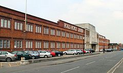
Rolls-Royce

From 1908 till 2007, Osmaston was the central location of the manufacturing unit of Rolls-Royce until this facility was moved 2 km south to Sinfin. The Nightingale Road Main Works site opened in 1908 to manufacture the Rolls-Royce Silver Ghost. The rear of the site had a test track called "Miniature Brooklands," which was used to prove the cars.

During World War II, on Monday, 27 July 1942, at 7.50 am, a lone Dornier Do 217 attacked the Rolls-Royce factory in the area, making Merlin Engines vital to the war effort. The aircraft, at a very low level, hit the central stores and the houses opposite with four bombs, three 550kg and one 250 kg. The plane then strafed civilians in the Osmaston area and shot down a barrage balloon before returning to base. Twenty-three people were killed, 12 in the works with the remainder in neighbouring houses in Hawthorn, Abingdon and Handel Street. [6] [7] Among those killed was Arthur Bacon, a former Derby County football player. [8] A further 120 people were injured.

On 27 July 2017, a memorial to those who died was unveiled behind the Marble Hall. Guest of honour was Sheila Dixon, who was nine years old when one of the bombs impacted two doors down from her home, killing her friend Dennis Regan. [9]

In April 2009, Derby City Council agreed to buy the old Rolls-Royce site in a move towards the ongoing regeneration of Osmaston. [10]

Education

Schools serving the Osmaston area are Nightingale Infant and Primary schools, which both have "Inadequate" Ofsted reports. [11]

Religious sites

Saint Bartholomew's Parish Church serves the area. The church was built in 1926 on land given by Mrs Walter Evans and was extended in 1966 to give a new Chancel, Lady Chapel and Vestries.

Osmaston Park

At the southern edge of Osmaston is a public park called Osmaston Park. It is 650 metres long by 250 metres wide with a patched perimeter of 1,500 metres. It has two grassed areas set aside as football pitches on either side of a central wooded circle called "Ash Wood," with an adventure playground. The park features basketball courts, a community centre and a BMX track.

Notable people

See also

Related Research Articles

<span class="mw-page-title-main">Normanton, Derby</span> Human settlement in England

Normanton is an inner city suburb and ward of the city of Derby in Derbyshire, England, situated approximately 2 miles (3.2 km) south of the city centre. Neighbouring suburbs include Littleover, Pear Tree, Rose Hill and Sunny Hill. The original village of Normanton-by-Derby, which now forms the southern part of the suburb, dates back to the medieval period. As the Normanton area became rapidly urbanised in the 19th century, the New Normanton area to the north was developed for housing, linking the old village to Derby, into which it was eventually absorbed. The area is characterised by high density late 19th century terraced housing in New Normanton and mid-20th century housing estates elsewhere, and has the most ethnically diverse population in Derby. The Normanton ward had a population of 17,071 in 2011.

<span class="mw-page-title-main">Chaddesden</span> Suburb of Derby, United Kingdom

Chaddesden, also known locally as Chadd, is a large residential suburb of Derby, in the ceremonial county of Derbyshire, England. Historically a separate village centred on Chaddesden Hall and the 14th century St Mary's Church, the area was significantly expanded by 20th-century housing developments, and became part of the then County Borough of Derby in 1968, prior to Derby's city status in 1977.

<span class="mw-page-title-main">Alvaston</span> Human settlement in England

Alvaston is a village and ward of Derby, in the ceremonial county of Derbyshire, England. Alvaston is on the A6 three miles south-east of Derby city centre and probably owes its name to an individual called Ælfwald.

<span class="mw-page-title-main">Derby South (UK Parliament constituency)</span> UK Parliament constituency since 1950

Derby South is a constituency formed of part of the city of Derby represented in the House of Commons of the UK Parliament since 1983 by veteran MP Margaret Beckett of the Labour Party. She has served under the Labour governments of Harold Wilson, James Callaghan, Tony Blair and Gordon Brown. She became interim Leader of the Labour Party in 1994 when John Smith suddenly died. She has also served under Neil Kinnock and Smith himself.

<span class="mw-page-title-main">Quarndon</span> Human settlement in England

Quarndon is a linear village in the south of the Amber Valley District of Derbyshire, England. It is spread along four minor upland roads, approximately 1 mile north of the Derby suburb of Allestree, two of which lead towards the city.

<span class="mw-page-title-main">Wilmorton</span> Human settlement in England

Wilmorton is a suburb of the city of Derby, England. It is situated between Alvaston and Osmaston, to the south of the city centre on the A6 from Deadman's Lane to the Canal Bridge; the former is aligned to the old town boundary and named from the medieval track that lead to the plague pit dug 1348 during the Great Plague or Black Death. Victims of the Black Death were buried there. It was given the name Wilmorton by the post office in 1887. The area was named after Reverend Sir George Wilmot-Horton, 5th Baronet of Osmaston and was formed out of the Osmaston Hall estate which was broken up in the 1880s.

<span class="mw-page-title-main">Peartree railway station</span> Railway station in Derbyshire, England

Peartree railway station is a railway station serving the areas of Pear Tree, Normanton and Osmaston in the city of Derby, England. It is one of three stations remaining open in the city, and is situated about one mile south of Derby station on the main line to Birmingham New Street. For a short period, Derby - Birmingham local services called at Peartree, but it is now served by four trains each way on weekdays on the Crewe–Derby line, a community rail line also known as the North Staffordshire line. The station is owned by Network Rail and managed by East Midlands Railway.

<span class="mw-page-title-main">Sinfin</span> Human settlement in England

Sinfin is a suburb of Derby, England, 3 miles (4.8 km) southwest of the city centre on its southern outskirts. The ward, which includes Osmaston as well as Sinfin itself, had a population of 15,128 in 2011. Historically, Sinfin and Osmaston were separate villages before being swallowed up by the expansion of Derby. Osmaston is characterised by inter-war housing developments while much of the housing in Sinfin is post-war. Between the two suburbs lies a more industrialised area dominated by the Rolls-Royce works.

<span class="mw-page-title-main">Brailsford</span> Human settlement in England

Brailsford is a small red-brick village and civil parish in Derbyshire on the A52 midway between Derby and Ashbourne. The parish also includes Brailsford Green. The civil parish population at the 2011 Census was 1,118. The village has a pub, a golf club, a post office and a school. There are many fine houses in the district including two 20th-century country houses: Brailsford Hall built in 1905 in Jacobean style, and Culland Hall.

<span class="mw-page-title-main">Sinfin Central railway station</span> Former railway station in England

Sinfin Central station was in the city of Derby, Derbyshire, England.

<span class="mw-page-title-main">Catton Hall</span> Building in Derbyshire, England

Catton Hall is a country house near the boundary between Derbyshire and Staffordshire, within the civil parish of Catton. It gives its postal address as Walton-on-Trent although there was a village of Catton at one time. It is a Grade II* listed building.

<span class="mw-page-title-main">Shottle</span> Human settlement in England

Shottle is a village approximately 3 miles (4.8 km) south of the market town of Wirksworth in Derbyshire. The population of the civil parish at the 2011 Census was 266.

<span class="mw-page-title-main">Derby</span> City in Derbyshire, England

Derby is a city and unitary authority area on the River Derwent in Derbyshire, England. Derbyshire is named after Derby, which was its original county town. As a unitary authority, Derby is administratively independent from Derbyshire County Council. The population of Derby is 261,136 (2021).

<span class="mw-page-title-main">Osmaston Hall</span> Building in Derbyshire, England

Osmaston Hall was a country house built in 1696 in extensive grounds at Osmaston, Derbyshire, now an area of the city of Derby. The house was the home of the Wilmot baronets, and the Fox family before being used for a golf club and railway business. It was demolished in 1938, with the site now occupied by an industrial estate.

<span class="mw-page-title-main">Hungry Bentley</span> Deserted medieval village in Derbyshire, England

Hungry Bentley is a deserted medieval village and civil parish in the Derbyshire Dales district of Derbyshire, England, between Uttoxeter and Derby. The site is a scheduled monument and has been called the best "depopulated settlement" in Derbyshire. The name Bentley is said to mean a clearing with bent grass. The more unusual appellation of "Hungry" is said to refer to the poor quality of the land and the local inhabitants' poor food.

<span class="mw-page-title-main">Catton, Derbyshire</span> Civil parish in Derbyshire, England

Catton is a civil parish within the South Derbyshire district, which is in the county of Derbyshire, England. Overwhelmingly rural, its population is reported alongside the adjacent parish of Coton in the Elms for a total of 896 residents in 2011. The parish is 100 miles (160 km) north west of London, 15 miles (24 km) south west of the county city of Derby, and 5 miles (8.0 km) south west of the nearest market town of Burton upon Trent. Being on the edge of the county border, it shares a boundary with the parishes of Coton in the Elms, Lullington and Walton upon Trent in Derbyshire, as well as Barton-under-Needwood, Edingale and Wychnor in Staffordshire. Catton Hall, a historic country house and the surrounding Catton Park are notable for hosting several annual events.

The following is a timeline of the history of the city of Derby, England.

<i>Rolls-Royce Battle of Britain Memorial Window</i> Stained glass window commemorating the Battle of Britain

The Rolls-Royce Battle of Britain Memorial Window, is a stained glass window designed by Hugh Ray Easton, to commemorate the pilots of the Royal Air Force who fought in the Battle of Britain and the contribution of Rolls-Royce engineering to their victory. It was unveiled on 11 January 1949 in Rolls-Royce's Nightingale Road factory in Osmaston, Derby.

<span class="mw-page-title-main">Marble Hall, Derby</span> Historic office block in Derby, England

The Marble Hall is an office block of the former Rolls-Royce Limited factory in Osmaston, Derby, in England. The factory was developed from 1907 to manufacture the Rolls-Royce Silver Ghost. The Marble Hall was built in 1912 and was the site of important decisions made during Rolls-Royce's history as a car and aircraft engine manufacturer. The Marble Hall was significantly altered in 1938 adding a classical style entrance way clad in Portland stone and a porte-cochère from which customers could collect their finished cars. The factory closed in 2008, the Marble Hall came into the ownership of Derby City Council and from 2014 was refurbished to provide offices for small and medium-sized enterprises.

<span class="mw-page-title-main">Edlaston and Wyaston</span> Civil parish in Derbyshire, England

Edlaston and Wyaston is a civil parish within the Derbyshire Dales district, in the county of Derbyshire, England. The parish includes the villages of Edlaston and Wyaston. In 2011 the parish had a population of 220, which increased to 241 in the census of 2021. It is 120 miles (190 km) north west of London, 11 miles (18 km) north west of the county city of Derby, and 2+12 miles (4 km) south of the market town of Ashbourne. Edlaston and Wyaston touches the parishes of Clifton and Compton, Osmaston, Rodsley, Shirley, Snelston and Yeaveley. There are seven listed buildings in Edlaston and Wyaston.

References

  1. 1 2 Kelly's Directory of the Counties of Derby, Notts, Leicester and Rutland Archived 4 May 2010 at the Wayback Machine . (London, 1891) p. 222. Retrieved 11 May 2010
  2. [History of Derbyshire' by David Peter Davies History of Derbyshire], David Peter Davies, 1911. Retrieved May 2010
  3. "Photo gallery". Archived from the original on 17 October 2009. Retrieved 11 May 2010.
  4. "Population statistics Osmaston Ch/CP through time". A Vision of Britain through Time . Retrieved 24 April 2024.
  5. "Shardlow Registration District". UKBMD. Retrieved 24 April 2024.
  6. "Air raid on Rolls-Royce: full story of the deadliest wartime attack on Derby – Derby Evening Telegraph". Archived from the original on 5 March 2023. Retrieved 24 April 2023.
  7. The Bombing of Rolls-Royce at Derby in two World Wars – with diversions – ISBN   1 872922 22 8
  8. "Commonwealth War Graves Commission – Civilian War Dead". Archived from the original on 28 July 2017. Retrieved 24 April 2023.
  9. "Loved ones remembered in memorial to victims of bombing 75 years ago – Derby Evening Telegraph". Archived from the original on 9 August 2022. Retrieved 24 April 2023.
  10. "Rolls-Royce land to be bought up for Osmaston master plan". Archived from the original on 1 July 2009. Retrieved 14 May 2010.
  11. "Nightingale Infant School". Archived from the original on 30 July 2017. Retrieved 24 April 2023.