Maddingley Mine is a mine near Bacchus Marsh Railway Station, [1] Victoria, Australia, that contains a concentration of a particular brown coal (lignite) formation called Leonardite. A relatively high altitude formation, Maddingley brown coal is distinguished as having 60% moisture content and a rich fulvic acid and humic acid content. [2] A declared strategic State mining reserve, the estimated 400 million tonne deposit at Maddingley is the largest of three known deposits of high value Leonardite in the world, the others occurring in Mexico and Germany.
The Maddingley brown coal deposit was surveyed by the 1930s. In the early 1940s brown coal was mined and transported in large quantities by rail from the nearby Rowsley Station, with dedicated trains running between Maddingley and the Australian Paper Manufacturers (APM Siding) at Fairfield, Melbourne. The coal was used to fire boilers at the APM paper mill, with 400 tonnes (440 short tons) of coal per day transferred in two trains per day. This traffic continued until the late 1970s when the boilers were converted to natural gas firing. [3]
From the 1970s to the late 1980s coal from the mine was used to fuel local boilers at the CRA/Visy cardboard manufacturing facility located at JBD Business Park, located adjacent to Rowsley Station. The cardboard plant was decommissioned by 1990. The mine was subsequently acquired by the Calleja Group, a family owned waste management and transport company, primarily as an EPA licensed landfill for construction and demolition and, commercial and industrial waste . By 1994 the Calleja Group had acquired ownership of a methodology to create densified coal. The company invested in the application of Maddingley brown coal as a soil conditioner and natural fertiliser replacement for super phosphate, and the development of bench test equipment to produce batch samples of densified coal. Around 1997 the working technology to achieve densified coal became known as the Coldry Process.

Lignite, often referred to as brown coal, is a soft, brown, combustible sedimentary rock formed from naturally compressed peat. It has a carbon content around 25–35% and is considered the lowest rank of coal due to its relatively low heat content. When removed from the ground, it contains a very high amount of moisture, which partially explains its low carbon content. Lignite is mined all around the world and is used almost exclusively as a fuel for steam-electric power generation.

Fairfield railway station is a suburban railway station located on the Hurstbridge line in the north-eastern Melbourne suburb of Fairfield in Victoria, Australia. It opened on 8 May 1888 as Fairfield Park and was renamed Fairfield on 14 November 1943.

Ardeer railway station is located on the Serviceton line in Victoria, Australia. It serves the western Melbourne suburb of Ardeer, and it opened on 2 April 1929.
The Outer Circle Railway was opened in stages in 1890 and 1891, as a steam-era suburban railway line, in Melbourne, Australia. It traversed much of the modern City of Boroondara, including the suburbs of Kew East, Camberwell, Burwood, Ashburton, and Malvern East. At its longest, it ran from Fairfield station, on what is today the Hurstbridge line, to Oakleigh station, on the current Gippsland line.
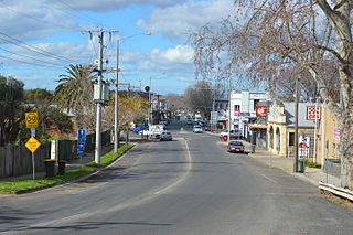
Bacchus Marsh is a peri-urban town in Victoria, Australia located approximately 50 kilometres (30 mi) north-west of the state capital Melbourne, at a near equidistance to the major cities of Melbourne, Ballarat and Geelong.
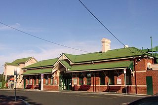
Bacchus Marsh railway station is located on the Serviceton line in Victoria, Australia. It opened on 10 February 1887, and serves the town of the same name, although the station is in the southern suburb of Maddingley.

The Yallourn Power Station, now owned by EnergyAustralia a wholly owned subsidiary of the Hong-Kong-based CLP Group, is located in the Latrobe Valley of Victoria, Australia, beside the Latrobe River, with the company town of Yallourn located to the south west. Yallourn PS was a complex of six brown coal–fired thermal power stations built progressively from the 1920s to the 1960s; all except one have now been decommissioned. Today, only the 1,450 megawatts (1,940,000 hp) Yallourn W plant remains. It is the second largest power station in Victoria, supplying 22% of Victoria's electricity and 8% of the National Electricity Market. The adjacent open cut brown coal mine is the largest open cut coal mine in Australia, with reserves sufficient to meet the projected needs of the power station to 2028. On 10 March 2021, EnergyAustralia announced that it will close the Yallourn Power Station in mid-2028, four years ahead of schedule, and instead build a 350 megawatt battery in the Latrobe Valley by the end of 2026. At the time, Yallourn produced about 20% of Victoria's electricity.

The Energy Brix Power Station was a brown coal–fired thermal power station located at Morwell, in Victoria, Australia. The power station was used to supply electricity for the retail market, as well as the production of briquettes in the adjacent Energy Brix briquette works. It was shut down in August 2014 and is currently the earliest surviving large-scale power station designed to provide electricity to the state electricity network.
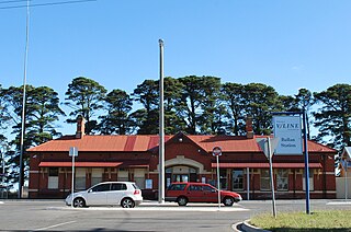
Ballan railway station is located on the Serviceton line in Victoria, Australia. It serves the town of Ballan, and it opened on 22 December 1886.

Parwan is a closed station located in the town of Parwan, near Bacchus Marsh, on the Ararat railway line in Victoria, Australia. The station platform was on the southern side of the line. Today, Parwan is a crossing loop, permitting trains up to 969 metres long to cross.

The APM Siding was a 1.125-kilometre (0.7 mi) long private railway siding in the suburb of Alphington, Melbourne, Australia, that served the Australian Paper Manufacturers paper mill. The siding branched from Fairfield station, on the Hurstbridge line, and ran south-east, passing through the intersection of Chandler Highway, Grange and Heidelberg Roads, and entering the factory.

The Ballarat V/Line rail service is a regional passenger rail service operated by V/Line in Victoria, Australia. It serves 13 stations towards its terminus in Ballarat's western suburb of Wendouree via Melton and Bacchus Marsh. Services are operated primarily using V/Line VLocity diesel multiple unit sets in either 3- or 6-car configurations.

The Shire of Bacchus Marsh was a local government area about 50 kilometres (31 mi) west of Melbourne, the state capital of Victoria, Australia. The shire covered an area of 565 square kilometres (218.1 sq mi), and existed from 1862 until 1994.
Refined coal is the product of the coal-upgrading technology that removes moisture and certain pollutants from lower-rank coals such as sub-bituminous and lignite (brown) coals, raising their calorific values. Coal refining or upgrading technologies are typically pre-combustion treatments and processes that alter the characteristics of coal before it is burned. Pre-combustion coal-upgrading technologies aim to increase efficiency and reduce emissions when coal is burned. Depending on the situation, pre-combustion technology can be used in place of or as a supplement to post-combustion technologies to control emissions from coal-fueled boilers.

Leonardite is a soft waxy, black or brown, shiny, vitreous mineraloid that is easily soluble in alkaline solutions. It is an oxidation product of lignite, associated with near-surface mining. It is a rich source of humic acid and is used as a soil conditioner, as a stabilizer for ion-exchange resins in water treatment, in the remediation of polluted environments and as a drilling additive. It was named after A. G. Leonard, first director of the North Dakota Geological Survey, in recognition of his work on these deposits.
Densified coal is the product of the Coldry Process coal upgrading technology that removes moisture from low-rank coals such as sub-bituminous and lignite/brown coal. The densification process raises the calorific value of low-rank coal to equal or exceed that of many export-grade black coals. Densified coal resulting from the Coldry Process is regarded as a black coal equivalent or replacement for black coal.
Black coal equivalent (BCE) is an export coal product derived from the Coldry Process, a patented coal upgrading technology operated by Environmental Clean Technologies Limited, in Victoria, Australia. The Coldry Process is applied to brown coal (lignite) with a typical moisture content of 60 per cent by weight and transforms the coal into a densified coal product of equal or better calorific value to typical export quality black coal, with less ash and sulfur content. Black coal equivalent derived from brown coal is ostensibly a 'cleaner' burning coal fuel than most black coals.

Nieuwesteeg Heritage Rose Garden is a collection of rare and unusual roses, mostly hybrid teas, bred in the early 20th century. It is located in Maddingley Park, Bacchus Marsh, a town and suburb some 50 kilometres (30 mi) west of Melbourne and 14 kilometres (9 mi) west of Melton. The rose garden was established from 2009, with stock donated by rosarian John Nieuwesteeg.

Maddingley is a suburb of Bacchus Marsh, a peri-urban town in central Victoria, Australia. The locality consists of the portion of the Bacchus Marsh urban area south of the Werribee River. It is in the Shire of Moorabool, 61 kilometres (38 mi) west north west of the state capital, Melbourne. At the 2021 census, Maddingley had a population of 5,491.
Rowsley railway station was a railway station on the Serviceton railway line. It was opened in 1889 when the track was laid through the small town of Rowsley, Victoria. A siding replaced the station in 1959. It was once the location of a branch line to Maddingley Mine.
| Coal types by grade (lowest to highest) |  | |
|---|---|---|
| Coal combustion | ||
| Coal mining |
| |
Note: [1] Peat is considered a precursor to coal. Graphite is only technically considered a coal type. | ||