The Coast Mountains are a major mountain range in the Pacific Coast Ranges of western North America, extending from southwestern Yukon through the Alaska Panhandle and virtually all of the Coast of British Columbia south to the Fraser River. The mountain range's name derives from its proximity to the sea coast, and it is often referred to as the Coast Range. The range includes volcanic and non-volcanic mountains and the extensive ice fields of the Pacific and Boundary Ranges, and the northern end of the volcanic system known as the Cascade Volcanoes. The Coast Mountains are part of a larger mountain system called the Pacific Coast Ranges or the Pacific Mountain System, which includes the Cascade Range, the Insular Mountains, the Olympic Mountains, the Oregon Coast Range, the California Coast Ranges, the Saint Elias Mountains and the Chugach Mountains. The Coast Mountains are also part of the American Cordillera—a Spanish term for an extensive chain of mountain ranges—that consists of an almost continuous sequence of mountain ranges that form the western backbone of North America, Central America, South America and Antarctica.

The Gakkel Ridge is a mid-oceanic ridge, a divergent tectonic plate boundary between the North American Plate and the Eurasian Plate. It is located in the Eurasian Basin of the Arctic Ocean, between Greenland and Siberia, and has a length of about 1,800 kilometers. Geologically, it connects the northern end of the Mid-Atlantic Ridge with the Laptev Sea Rift.
Hydrothermal circulation in its most general sense is the circulation of hot water. Hydrothermal circulation occurs most often in the vicinity of sources of heat within the Earth's crust. In general, this occurs near volcanic activity, but can occur in the deep crust related to the intrusion of granite, or as the result of orogeny or metamorphism.

A hydrothermal vent is a fissure on the seafloor from which geothermally heated water discharges. Hydrothermal vents are commonly found near volcanically active places, areas where tectonic plates are moving apart at spreading centers, ocean basins, and hotspots. Hydrothermal deposits are rocks and mineral ore deposits formed by the action of hydrothermal vents.
Volcanogenic massive sulfide ore deposits, also known as VMS ore deposits, are a type of metal sulfide ore deposit, mainly copper-zinc which are associated with and created by volcanic-associated hydrothermal events in submarine environments.

Marine geology or geological oceanography is the study of the history and structure of the ocean floor. It involves geophysical, geochemical, sedimentological and paleontological investigations of the ocean floor and coastal zone. Marine geology has strong ties to geophysics and to physical oceanography.

A mid-ocean ridge (MOR) is a seafloor mountain system formed by plate tectonics. It typically has a depth of ~ 2,600 meters (8,500 ft) and rises about two kilometers above the deepest portion of an ocean basin. This feature is where seafloor spreading takes place along a divergent plate boundary. The rate of seafloor spreading determines the morphology of the crest of the mid-ocean ridge and its width in an ocean basin. The production of new seafloor and oceanic lithosphere results from mantle upwelling in response to plate separation. The melt rises as magma at the linear weakness between the separating plates, and emerges as lava, creating new oceanic crust and lithosphere upon cooling. The first discovered mid-ocean ridge was the Mid-Atlantic Ridge, which is a spreading center that bisects the North and South Atlantic basins; hence the origin of the name 'mid-ocean ridge'. Most oceanic spreading centers are not in the middle of their hosting ocean basis but regardless, are traditionally called mid-ocean ridges. Mid-ocean ridges around the globe are linked by plate tectonic boundaries and the trace of the ridges across the ocean floor appears similar to the seam of a baseball. The mid-ocean ridge system thus is the longest mountain range on Earth, reaching about 65,000 km (40,000 mi).

The Juan de Fuca Ridge is a mid-ocean spreading center and divergent plate boundary located off the coast of the Pacific Northwest region of North America. The ridge separates the Pacific Plate to the west and the Juan de Fuca Plate to the east. It runs generally northward, with a length of approximately 500 kilometers. The ridge is a section of what remains from the larger Pacific-Farallon Ridge which used to be the primary spreading center of this region, driving the Farallon Plate underneath the North American Plate through the process of plate tectonics. Today, the Juan de Fuca Ridge pushes the Juan de Fuca Plate underneath the North American plate, forming the Cascadia Subduction Zone.

Vernadskii Ridge is a volcanic group located in the northern part of Paramushir Island, Kuril Islands, Russia.

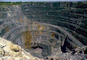
Volcanic activity is a major part of the geology of Canada and is characterized by many types of volcanic landform, including lava flows, volcanic plateaus, lava domes, cinder cones, stratovolcanoes, shield volcanoes, submarine volcanoes, calderas, diatremes, and maars, along with less common volcanic forms such as tuyas and subglacial mounds.

The Explorer Ridge is a mid-ocean ridge, a divergent tectonic plate boundary located about 241 km (150 mi) west of Vancouver Island, British Columbia, Canada. It lies at the northern extremity of the Pacific spreading axis. To its east is the Explorer Plate, which together with the Juan de Fuca Plate and the Gorda Plate to its south, is what remains of the once-vast Farallon Plate which has been largely subducted under the North American Plate. The Explorer Ridge consists of one major segment, the Southern Explorer Ridge, and several smaller segments. It runs northward from the Sovanco Fracture Zone to the Queen Charlotte Triple Junction, a point where it meets the Queen Charlotte Fault and the northern Cascadia subduction zone.
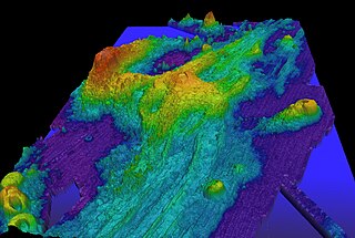
Axial Seamount is a seamount and submarine volcano located on the Juan de Fuca Ridge, approximately 480 km (298 mi) west of Cannon Beach, Oregon. Standing 1,100 m (3,609 ft) high, Axial Seamount is the youngest volcano and current eruptive center of the Cobb–Eickelberg Seamount chain. Located at the center of both a geological hotspot and a mid-ocean ridge, the seamount is geologically complex, and its origins are still poorly understood. Axial Seamount is set on a long, low-lying plateau, with two large rift zones trending 50 km (31 mi) to the northeast and southwest of its center. The volcano features an unusual rectangular caldera, and its flanks are pockmarked by fissures, vents, sheet flows, and pit craters up to 100 m (328 ft) deep; its geology is further complicated by its intersection with several smaller seamounts surrounding it.

Bowie Seamount is a large submarine volcano in the northeastern Pacific Ocean, located 180 km (110 mi) west of Haida Gwaii, British Columbia, Canada.

The Explorer Seamount is a seamount located in the Pacific Ocean off the coast of British Columbia, Canada. It is on the Explorer Ridge, a tectonic spreading centre that separates the Pacific and Explorer plates and so the volcanism is rift-related. It is the namesake of the Explorer Ridge.

The Endeavor Hydrothermal Vents are a group of hydrothermal vents in the northeastern Pacific Ocean, located 260 kilometres (160 mi) southwest of Vancouver Island, British Columbia, Canada.

The hydrothermal vents and seamounts of the Azores are a series of Atlantic seamounts and hydrothermal vents that are part of the Mid-Atlantic Ridge system, giving rise to the archipelago and bathymetric region of the Azores. These geological structures, formed from masses of basalt, are of a geomorphological interest due to their rich deposits of ore. In addition it fosters a rich ecosystem of diverse subaquatic plant and animal life. There are food chains within this environment, for example, that are purely chemosynthetic, and do not need sunlight for photosynthesis.
Jack Gordon Souther was an American-born Canadian geologist, volcanologist, professor and engineer. He contributed significantly to the early understanding of recent volcanic activity in the Canadian Cordillera. Many of his publications continue to be regarded as classics in their field, even now several decades after they were written.

Foundation Seamounts are a series of seamounts in the southern Pacific Ocean. Discovered in 1992, these seamounts form a 1,350 kilometres (840 mi) long chain which starts from the Pacific-Antarctic Ridge. Some of these seamounts may have once emerged from the ocean.
Monowai is a volcanic seamount to the north of New Zealand. It is formed by a large caldera and a volcanic cone just south-southeast from the caldera. The volcanic cone rises to depths of up to 100 metres (330 ft) but its depth varies with ongoing volcanic activity, including sector collapses and the growth of lava domes. The seamount and its volcanism were discovered after 1877, but only in 1980 was it named "Monowai" after a research ship of the same name.
Kemp Caldera and Kemp Seamount form a submarine volcano south of the South Sandwich Islands, in a region where several seamounts are located. The seamount rises to a depth of 80 metres (260 ft) below sea level; the caldera has a diameter of 8.3 by 6.5 kilometres and reaches a depth of 1,600 metres (5,200 ft). The caldera contains several Hydrothermal vents, including white smokers and diffuse venting areas, which are host to chemolithotrophic ecological communities. The seamount and caldera, which were discovered by seafloor mapping in 2009, are part of the South Georgia and the South Sandwich Islands Marine Protected Area.
