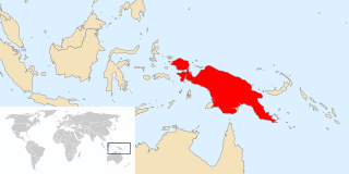
Papua is the largest and easternmost province of Indonesia, comprising most of Western New Guinea. It is bordered by the state of Papua New Guinea to the east, the province of West Papua to the west, the Pacific Ocean to the north, and the Arafura Sea to the south. According to the 2010 census by Statistics Indonesia, Papua had a population of 2,833,381, the majority of whom are Christians. The 2015 Intermediate Census revealed a population of 3,143,088, while the latest official estimate is 3,347,100. The province is divided into twenty-eight regencies and one city. Its capital and largest city is Jayapura.

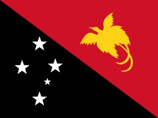
Papua New Guinea, officially the Independent State of Papua New Guinea, is a sovereign state in Oceania that occupies the eastern half of the island of New Guinea and its offshore islands in Melanesia, a region of the southwestern Pacific Ocean north of Australia. Its capital, located along its southeastern coast, is Port Moresby. The western half of New Guinea forms the Indonesian provinces of Papua and West Papua. It is the world's third largest island country with 462,840 km2 (178,700 sq mi).

For administrative purposes, Papua New Guinea is divided into administrative divisions called provinces. There are 22 province-level divisions, which include 20 provinces, the autonomous region of Bougainville and the National Capital District of Port Moresby.

The Gulf of Papua is a 400 kilometer wide region on the south coast of New Guinea.

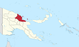
Madang is a province of Papua New Guinea. The province is on the northern coast of mainland Papua New Guinea and has many of the country's highest peaks, active volcanoes and its biggest mix of languages. The capital is the town of Madang.

The Penan are a nomadic indigenous people living in Sarawak and Brunei, although there is only one small community in Brunei; among those in Brunei half have been converted to Islam, even if only superficially. Penan are one of the last such peoples remaining as hunters and gatherers. The Penan are noted for their practice of 'molong' which means never taking more than necessary. Most Penan were nomadic hunter-gatherers until the post-World War II missionaries settled many of the Penan, mainly in the Ulu-Baram district but also in the Limbang district. They eat plants, which are also used as medicines, and animals and use the hides, skin, fur, and other parts for clothing and shelter.

Western Province is a coastal province in southwestern Papua New Guinea, bordering the Indonesian province of Papua. The provincial capital is Daru. The largest town in the province is Tabubil. Other major settlements are Kiunga, Ningerum, Olsobip and Balimo.

Tabubil is a town, company operated township located in the Star Mountains area of the North Fly District of Western Province, Papua New Guinea. The town, including the adjoining relocated village of Wangabin and the industrial area of Laydown, is the largest settlement in the province, although the provincial capital, Daru is a similar size. It had a recorded population of 10,270 at the 2011 census.
Gogodala is the name of an ethnic/language group from the Middle Fly District of the Western Province of Papua New Guinea. They speak the Gogodala language, which belongs to the Trans-New Guinea language family. It is one of about a thousand distinct ethnic groups in the country, each which has its own language and culture.

The Ok Tedi Mine is an open-pit copper and gold mine in Papua New Guinea located near the headwaters of the Ok Tedi River, in the Star Mountains Rural LLG of the North Fly District of the Western Province of Papua New Guinea.

The Anglican Church of Papua New Guinea is a province of the Anglican Communion. It was created in 1976 when the Province of Papua New Guinea became independent from the Province of Queensland in the Church of England in Australia following Papua New Guinea's independence in 1975.

The Rainforest Foundation Fund is a charitable foundation founded in 1987 and dedicated to drawing attention to rainforests and defending the rights of indigenous peoples living there.

Papua New Guinea together with the West Papua region of Indonesia make up a major tropical wilderness area that still contains 5% of the original and untouched tropical high-biodiversity terrestrial ecosystems. PNG in itself contains over 5% of the world's biodiversity in less than 1% of the world's total land area. The flora of New Guinea is unique because it has two sources of origin. The Gondwana flora from the south and flora with Asian origin from the west, as a result New Guinea shares major family and genera with Australia and the East Asia, but is rich in local endemic species. The endemicity is a result of mountainous isolation, topographic and soil habitat heterogeneity, high forest disturbance rates and abundant aseasonal rainfall year-round. PNG boasts some 15-21,000 higher plants, 3,000 species of orchids, 800 species of coral, 600 species of fish, 250 species of mammals and 760 species of birds and 8 species of tree-kangaroos out of which 84 genera of animals are endemic. Ecosystems range from lowland forests to montane forests, alpine flora down to coastal areas which contains some of the most extensive pristine mangrove areas in the world. Much of this biodiversity has remained intact for thousands of years because the ruggedness of the terrain made the interior lands inaccessible; furthermore low population density and restrictions on the effectiveness of traditional tools, ensured that these biodiversity was never overexploited.

New Guinea is the world's second-largest island and with an area of 785,753 km2 (303,381 sq mi) the largest island wholly or partly within the Southern Hemisphere and Oceania. Located in Melanesia in the southwestern Pacific Ocean, it is separated by the shallow and 150-kilometre wide Torres Strait from the Australian continent and is neighboured by a large number of smaller islands to the west and east.

Sangara is a settlement in south-eastern Papua New Guinea. It is located to the east of Kokoda.

Deforestation in Indonesia involves the long-term loss of forests and foliage across much of the country; it has had massive environmental and social impacts. Indonesia is home to some of the most biologically diverse forests in the world and ranks third in number of species behind Brazil and the Democratic Republic of Congo.

Deforestation in Papua New Guinea has been extensive in recent decades and is continuing at an estimated rate of 1.4% of tropical forest being lost annually. Deforestation in Papua New Guinea is mainly a result of illegal logging, which contributed to 70-90% of all timber exports, one of the highest rates in the world. Illegal logging is linked to corruption, environmental issues and human rights concerns.

Yalu is a large village in Wampar Rural LLG, located in the Markham Valley of Morobe Province, Papua New Guinea. It lies along the Highlands Highway 21.5 kilometres (13.4 mi) north-west of Lae, 7 kilometres (4.3 mi) southeast of Nadzab. The landscape is typically lowland rainforest.

The Kokoda Track Foundation (KTF) is an international aid organisation working in Papua New Guinea. The foundation was established in 2003 and supports the indigenous people of that country. The Foundation provides education, health, and community service programmes such as disaster relief, microbusiness promotion and sustainable ecotourism.

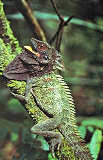
Lophosaurus dilophus, the crowned forest dragon or Indonesian forest dragon, is a large arboreal agamid lizard found in New Guinea and the Moluccan islands, Indonesia.