Malagarasi River

Last updated
Malagarasi River
Malagarasi OSM.png
Location
Country Burundi
Country Tanzania
Physical characteristics
Mouth  
  coordinates
5°15′23″S29°48′6″E / 5.25639°S 29.80167°E / -5.25639; 29.80167
Length475 km (295 mi)
Basin size130,000 km2 (50,000 sq mi)
Basin features
River system Congo River

The Malagarasi River is a river in western Tanzania, flowing through Kigoma Region, although one of its tributaries comes from southeastern Burundi. The river also forms the western border of Tabora Region, the southern border of Kagera Region and the southwestern border of Geita Region. It is the second-longest river in Tanzania behind the RufijiGreat Ruaha, and has the largest watershed of any river flowing into Lake Tanganyika. [1] The Malagarasi-Muyovozi Wetlands are a designated a Ramsar site. Local tribes have nicknamed the Malagarasi as "the river of bad spirits".

Contents

Geography

The Malagarasi is the second-longest river in Tanzania, at 475 kilometres (295 mi). [2] [3]

The source of the river is near the Tanzania-Burundi border. [1] The first 80 kilometres (50 mi) of the river form the international boundary between Tanzania and Burundi. Several tributaries from the Burundi highlands join its right bank. After the confluence with the Lumpungu River, the Malagarasi enters Tanzania, makes a circle and empties into the eastern side of Lake Tanganyika about 25 miles (40 km) south of Kigoma, near Ilagala. [4] It is one of the lake's primary inflows. Moyowosi River is the principal tributary, along with its affluent the Nikongo River; [5] other tributaries include Ugalla River, Gombe River, Ruchugi River, Lumpungu River, [6] and Nguya River. It is characterized as a low stream river, [7] and its drainage includes four biotopes: swampy areas, river channels, a flowing river with a few moderate rapids, and a large double-branched delta. [8]

The flow of the river ranges dramatically between the annual cycle of wet and dry seasons, and at times may be susceptible to flooding or reduced to a small stream; flow is also affected by local agriculture and deforestation which increase the level of sediments within the river. [1] At Mberagule, the flow of the river has been gauged to be 6.9 cubic kilometers per year. [1] About 80 kilometres (50 mi) from the mouth, the river flows through the Moyowosi swamplands, an area of "extensive swamps and floodplains" and a "marshy labyrinth". [9] [10] It passes through the Dodoma Belt, a geological area of Archaean and Proterozoic age Precambrian crystalline rocks. [1]

Watershed

With a basin area of 130,000 square kilometres (50,000 sq mi), the Malagarasi has the largest watershed of all of the rivers flowing into Lake Tanganyika. [1] The Malagarasi watershed constitutes 30% of the Lake Tanganyika's total watershed area. [11]

The Malagarasi watershed is bounded on the north by the watershed of Lake Victoria, on the east by the closed basin of the Southern Eastern Rift, to the south by the closed basin of Lake Rukwa, and to the east by Lake Tanganyika. [12]

Most of the basin is miombo woodland, with Brachystegia spiciformis and Julbernardia globiflora as the dominant trees. [13] There are extensive areas of flooded grassland in the central Malagarasi-Moyowosi basin, and along the middle Ugalla River to the southwest. [14]

History

According to ecologist Rosemary Lowe-McConnell, "the Malagarasi and the Rungwa River are assumed to be relict headwaters of the extended pre-rift Zaire system". [15] The Malagarasi pre-dates Lake Tanganyika and was in pre-rift times a tributary of the Congo River to its west. Lake Tanganyika has since said to have "undergone both transgression and regression, depositing new sediments, altering the delta, and changing the course of the river". [1] Over its history, the lake level has altered dramatically between 100 and 200 metres (330 and 660 ft); historical accounts from the late nineteenth century indicate that it was about 10 metres (33 ft) higher than it is today. [1]

Culture

Local tribes have nicknamed the Malagarasi as "the river of bad spirits". [16] In the late 19th century, the Wavinza people, who ran the river's ferry service from the left bank, avoided assimilation with the Wanyamwezi people because of the natural barrier formed by the Malagarasi. [17] Also on the other bank were the Wangoni (Watutu Zulus). [18] Henry Morton Stanley, who considered missionaries important to Africa's "civilizing process", stated that missionaries could follow the Malagarasi and participate in "conversion-tours to Uvinza, Uha, and Ugala". [19]

Flora and fauna

The tree species in the Malagarasi basin include Albizia gummifera , Bridelia micrantha , Cyperus papyrus , Diospyros mespiliformis , Ficus sycomorus , Ficus verruculosa , Isoberlinia spp., Khaya senegalensis , Parkia filicoidea , Phoenix reclinata , Syzygium cordatum , and Syzygium owariense . [5] The prominent grasses in the valley grasslands are species of Hyparrhenia , Themeda , and Echinochloa . [20]

The Malagarasi sardine (Mesobola spinifer) is endemic to the river. [21] The Malagarasi contains several fish species which occur in the Congo River Basin but not in Lake Tanganyika. [5] Giant freshwater Mbu pufferfish, however, occur in both the Central and Upper Zaire Basin and the Malagarasi River. [22]

Malagarasi-Muyovozi Wetlands

The Malagarasi-Muyovozi Wetlands lie in the middle of the basin, at 1200 meters elevation at the confluence of the Malagarasi with the Gombe, Muyovozi, Ugalla, and other tributary rivers. The wetland includes 250,000 hectares (620,000 acres) of dry-season lakes and open water including Sagara and Nyamagoma lakes, and 200,000 hectares (490,000 acres) of permanent papyrus swamp. Seasonally-flooded grasslands on the surrounding floodplain vary seasonally and with annual rainfall, and can cover up to 1.5 million hectares (3.7×10^6 acres). [23]

The papyrus swamps are dominated by the sedge Cyperus papyrus and the grass Oryza barthii . The seasonally-flooded grasslands include Hyparrhenia rufa and Echinochloa pyramidalis , with Hyparrhenia dominant in the least-flooded areas, Echinochloa in more frequently-flooded areas, and Vossia nearest the permanent wetlands. [24]

The middle and upper reaches of the Ugalla River include a seasonally-inundated floodplain 120 kilometres (75 mi) long and up to 50 kilometres (31 mi) wide. The floodplain supports extensive grasslands, dominated by the grasses Echinochloa haploclada, Themeda triandra, Setaria spp., Andropogon spp., Eragrostis spp., Digitaria spp., and Sporobolus spp. The floodplains include scattered trees including Combretum fragrans, C. obovatum and C. purpureiflorum , groves of the palm Borassus aethiopum , and small patches of closed-canopy forest on large termite mounds. [25]

Vulnerable and endangered animals in the wetland include Shoebill (Balaeniceps rex), Wattled crane (Bugeranus carunculatus), African bush elephant (Loxodonta africana), Sitatunga (Tragalephus spekii) and Central African slender-snouted crocodile (Mecistops leptorhynchus). The wetlands are home to 50 species of fish, including the Dark stonebasher (Pollimyrus nigricans) and various endangered, endemic, and food species. [26] [27] Waterbuck (Kobus ellipsiprymnus) and hippopotamus (Hippopotamus amphibius) are common in the wetlands. [20] Concerns have been raised over hippo poaching in the river basin by the Wanyahosa people, who prefer the meat over fish. [28]

Protected areas

The Malagarasi-Muyovozi Wetlands became a designated a Ramsar site on April 13, 2000. [29] It is the country's first Ramsar Site. At 35,000 square kilometres (14,000 sq mi) it is the world's third-largest Ramsar Site. [27]

Related Research Articles

<span class="mw-page-title-main">Geography of Tanzania</span>

Tanzania comprises many lakes, national parks, and Africa's highest point, Mount Kilimanjaro. Northeast Tanzania is mountainous, while the central area is part of a large plateau covered in grasslands. The country also contains the southern portion of Lake Victoria on its northern border with Uganda and Kenya.

<span class="mw-page-title-main">Sudd</span> Swamp in South Sudan

The Sudd is a vast swamp in South Sudan, formed by the White Nile's Baḥr al-Jabal section. The Arabic word sudd is derived from sadd, meaning "barrier" or "obstruction". The term "the sudd" has come to refer to any large solid floating vegetation island or mat. The area which the swamp covers is one of the world's largest wetlands and the largest freshwater wetland in the Nile Basin.

<span class="mw-page-title-main">Rift Valley lakes</span> Group of lakes in the East African Rift

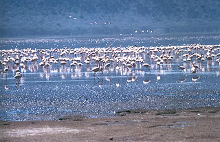
The Rift Valley lakes are a series of lakes in the East African Rift valley that runs through eastern Africa from Ethiopia in the north to Malawi in the south, and includes the African Great Lakes in the south. These include some of the world's oldest lakes, deepest lakes, largest lakes by area, and largest lakes by volume. Many are freshwater ecoregions of great biodiversity, while others are alkaline "soda lakes" supporting highly specialised organisms.

<span class="mw-page-title-main">Inner Niger Delta</span> Inland delta of the Niger River

The Inner Niger Delta, also known as the Macina or Masina, is the inland delta of the Niger River. It is an area of fluvial wetlands, lakes and floodplains in the semi-arid Sahel area of central Mali, just south of the Sahara desert.

<span class="mw-page-title-main">Wildlife of Burundi</span> Flora and fauna in Burundi

The wildlife of Burundi is composed of its flora and fauna. The small, landlocked country is home to 2,950 species of plants, 596 birds, 163 species of mammals, 52 species of reptiles, 56 species of amphibians, and 215 fish species. The wildlife has been drastically reduced in recent years, mainly on account of intense population pressure, conversion of large areas of forest into agricultural land, and extensive livestock farming. The protected area encompasses little more than 5% of the total area of the country.

<span class="mw-page-title-main">Zambezian flooded grasslands</span> Flooded grassland ecoregion in Africa

The Zambezian flooded grasslands is an ecoregion of southern and eastern Africa that is rich in wildlife.

The biomes and ecoregions in the ecology of Zambia are described, listed and mapped here, following the World Wildlife Fund's classification scheme for terrestrial ecoregions, and the WWF freshwater ecoregion classification for rivers, lakes and wetlands. Zambia is in the Zambezian region of the Afrotropical biogeographic realm. Three terrestrial biomes are well represented in the country . The distribution of the biomes and ecoregions is governed mainly by the physical environment, especially climate.

<span class="mw-page-title-main">Barotse Floodplain</span> Major floodplain in Central Africa

The Barotse Floodplain, also known as the Bulozi Plain, Lyondo or the Zambezi Floodplain, is one of Africa's great wetlands, on the Zambezi River in the Western Province of Zambia. It is a designated Ramsar site, regarded as being of high conservation value.

<span class="mw-page-title-main">Lake Chad flooded savanna</span> Flooded grassland ecoregion in Africa

The Lake Chad flooded savanna is a flooded grasslands and savannas ecoregion in Africa. It includes the seasonally- and permanently-flooded grasslands and savannas in the basin of Lake Chad in Central Africa, and covers portions of Cameroon, Chad, Niger, and Nigeria.

<span class="mw-page-title-main">Zambezian coastal flooded savanna</span>

The Zambezian coastal flooded savanna is a flooded grasslands and savannas ecoregion in Mozambique. It includes the coastal flooded savannas and grasslands in the deltas of the Zambezi, Pungwe, Buzi, and Save rivers.

<span class="mw-page-title-main">Ugalla River National Park</span> Protected area in Tanzania

The Ugalla River National Park is a Tanzanian national park in Tabora Region, of west-central Tanzania. The park covers 3,865 square kilometres (1,492.28 sq mi). It is bounded on the south by the Ugalla River.

The Kigosi National Park (Hifadhi ya Taifa ya Kigosi, In Swahili) is a national park located in Shinyanga Region, Geita Region and northwest Tabora Region of Tanzania. In 2019, Kigosi National Park was created. Kigosi National Park was established in 2019. It is a part of the Moyowosi/Malagarasi wetlands complex, which is the largest wetlands complex in East Africa, and has an area of 8,265 km2. The Malagarasi, Moyowosi, Nikonga, Ugalla, Kigosi, Nikonga, and Gombe are seven slow-moving rivers that meander through a vast and intricate network of marshes, plains lakes, and woodlands. These rivers should not be confused with the Gombe Stream National Park where the chimpanzees live. These rivers eventually combine to form the Malagarasi River, which empties into Ilagala's Lake Tanganyika. With a total area of almost 92,000 square kilometers, the wetland system is larger than the entire country of Portugal.

<span class="mw-page-title-main">Coongie Lakes</span> Salt lake in Far North, South Australia

The Coongie Lakes is a freshwater wetland system located in the Far North region of South Australia. The 21,790-square-kilometre (8,410 sq mi) lakes system is located approximately 1,046 kilometres north of the Adelaide city centre. The wetlands includes lakes, channels, billabongs, shallow floodplains, deltas, and interdune swamps. It lies on the floodplain of Cooper Creek, an ephemeral river flowing through a desert landscape in the Lake Eyre Basin which rarely, after occasional large floods, empties into Lake Eyre. The wetland system has been recognised both as being of international importance by designation under the Ramsar Convention with a listing on 15 June 1987 and being nationally important within Australia with a listing in A Directory of Important Wetlands in Australia (DIWA). Its extent includes the regional town of Innamincka, the Malkumba-Coongie Lakes National Park, the Innamincka Regional Reserve, the Strzelecki Regional Reserve and the Coongie Lakes Important Bird Area.


The Wembere River is a river located in north western Singida Region, Tanzania. The river is part of the water basin of Lake Eyasi.

The Yaéré, from Fula yaayre, is the name of a vast annually-flooded grassland and savanna, part of the extensive floodplains around the shallow and variable Lake Chad in Central Africa. The Yaéré is part of the Lake Chad flooded savanna ecoregion.

<span class="mw-page-title-main">Lanigan Creek</span> River in Saskatchewan, Canada

Lanigan Creek is a river in the Canadian province of Saskatchewan. It is located in the south central part of the province in a region called the Prairie Pothole Region of North America, which extends throughout three Canadian provinces and five U.S. states. It is also within Palliser's Triangle and the Great Plains ecoregion.

<span class="mw-page-title-main">Likouala-aux-Herbes</span> River in Likouala, Republic of the Congo

The Likouala-aux-Herbes is a river in the Republic of the Congo. It is a tributary of the Sangha River, which in turn is a tributary of the Congo River. It gives its name to the Likouala Department.

References

  1. 1 2 3 4 5 6 7 8 Shick, Kate; Flaccus, Kathy. "Malagarasi River Delta Sedimentology: Evidence of Lake Level Changes in Lake Tanganyika" (PDF). Geology Department of the University of Arizona . Retrieved 30 May 2012.
  2. Kisangani, Emizet F.; Bobb, F. Scott (2010). Historical Dictionary of the Democratic Republic of the Congo. Scarecrow Press. p. 299. ISBN   978-0-8108-5761-2 . Retrieved 30 May 2012.
  3. Elf-Aquitaine (Company) (1992). Bulletin des centres de recherches exploration-production Elf-Aquitaine. Société nationale Elf-Aquitaine (Production). Retrieved 30 May 2012.
  4. Maps (Map). Google Maps.
  5. 1 2 3 Hughes, R. H.; Hughes, J. S. (1992). A Directory of African Wetlands. IUCN. pp. 244–. ISBN   978-2-88032-949-5 . Retrieved 28 May 2012.
  6. Brownlie, Ian; Burns, Ian R. (1979). African Boundaries: A Legal and Diplomatic Encyclopaedia. C. Hurst. p. 748. ISBN   978-0-903983-87-7 . Retrieved 30 May 2012.
  7. Klerkx, J.; Imanackunov, Beishen (1 January 2003). Lake Issyk-Kul: Its Natural Environment. Springer. pp. 231–. ISBN   978-1-4020-0900-6 . Retrieved 28 May 2012.
  8. Thieme, Michele L. (5 April 2005). Freshwater Ecoregions of Africa and Madagascar: A Conservation Assessment. Island Press. pp. 197–. ISBN   978-1-55963-365-9 . Retrieved 28 May 2012.
  9. Kamukala, G. L.; Crafter, S. A. (1993). Wetlands of Tanzania: Proceedings of a Seminar on the Wetlands of Tanzania, Morogoro, Tanzania, 27-29 November, 1991. IUCN Wetlands Programme. p. 34. ISBN   978-2-8317-0185-1 . Retrieved 30 May 2012.
  10. Lambrecht, Frank L. (1991). In the Shade of an Acacia Tree: Memoirs of a Health Officer in Africa, 1945-1959. American Philosophical Society. p. 217. ISBN   978-0-87169-194-1 . Retrieved 30 May 2012.
  11. Director of Wildlife, Wildlife Division of the United Republic of Tanzania (1999). "The Malagarasi-Muyovozi Wetlands". Information Sheet on Ramsar Wetlands, 21-08-1999. Accessed 18 September 2019.
  12. "Malagarasi-Moyowosi". Freshwater Ecoregions of the World (FEOW). Accessed 18 September 2019.
  13. "Malagarasi-Moyowosi". Freshwater Ecoregions of the World (FEOW). Accessed 18 September 2019.
  14. "Zambezian Flooded Grasslands". WWF ecoregion profile, accessed 18 September 2019.
  15. Lévêque, C. (13 May 1997). Biodiversity Dynamics and Conservation: The Freshwater Fish of Tropical Africa. Cambridge University Press. pp. 107–. ISBN   978-0-521-57033-6 . Retrieved 28 May 2012.
  16. Grant, Richard (25 October 2011). Crazy River: Exploration and Folly in East Africa. Simon and Schuster. pp. 339–. ISBN   978-1-4391-5414-4 . Retrieved 4 June 2012.
  17. The Journal of the Anthropological Institute of Great Britain and Ireland (Public domain ed.). Anthropological Institute of Great Britain and Ireland. 1883. pp. 8–. Retrieved 4 June 2012.
  18. Newman, James L. (2010). Paths Without Glory: Richard Francis Burton in Africa. Potomac Books, Inc. pp. 105–. ISBN   978-1-59797-287-1 . Retrieved 4 June 2012.
  19. Newman, James L. (1 November 2004). Imperial Footprints: Henry Morton Stanley's African Journeys. Potomac Books, Inc. pp. 81–. ISBN   978-1-57488-597-2 . Retrieved 4 June 2012.
  20. 1 2 Tanzania Society (1980). Tanzania notes and records. Tanzania Society. pp. 96–100. Retrieved 30 May 2012.
  21. Seegers, L. (November 15, 2011). "Mesobola spinifer (Bailey & Matthes, 1971) Malagarasi sardine". FishBase. Retrieved 29 May 2012.
  22. Davies, Bryan Robert (31 July 1986). The Ecology of River Systems. Springer. p. 218. ISBN   978-90-6193-540-7 . Retrieved 30 May 2012.
  23. Director of Wildlife, Wildlife Division of the United Republic of Tanzania (1999). "The Malagarasi-Muyovozi Wetlands". Information Sheet on Ramsar Wetlands, 21-08-1999. Accessed 18 September 2019.
  24. Director of Wildlife, Wildlife Division of the United Republic of Tanzania (1999). "The Malagarasi-Muyovozi Wetlands". Information Sheet on Ramsar Wetlands, 21-08-1999. Accessed 18 September 2019.
  25. Director of Wildlife, Wildlife Division of the United Republic of Tanzania (1999). "The Malagarasi-Muyovozi Wetlands". Information Sheet on Ramsar Wetlands, 21-08-1999. Accessed 18 September 2019.
  26. Director of Wildlife, Wildlife Division of the United Republic of Tanzania (1999). "The Malagarasi-Muyovozi Wetlands". Information Sheet on Ramsar Wetlands, 21-08-1999. Accessed 18 September 2019.
  27. 1 2 "The Project for Sustainable and Integrated Management of the Malagarasi-Muyovozi Ramsar Site (SIMMORS)". Ramsar. March 2007. Retrieved 2 June 2012.
  28. Tanganyika Society (1963). Tanganyika notes and records. Tanganyika Society. p. 210. Retrieved 30 May 2012.
  29. "TANZANIA, UNITED REPUBLIC OF Ramsar Site 1024;(WI Site 1TZ001)". Wetlands International. Archived from the original on 16 April 2013. Retrieved 2 June 2012.