Malinao, Albay

Last updated
Malinao
Municipality of Malinao
Spanish Cemetery of Malinao, Albay - Flickr.jpg
Spanish-era cemetery of Malinao
Flag of Malinao, Albay.png
Nickname: 
The Wonderland of Albay
Ph locator albay malinao.png
Map of Albay with Malinao highlighted
OpenStreetMap
Malinao, Albay
Philippines location map (square).svg
Red pog.svg
Malinao
Location within the Philippines
Coordinates: 13°24′N123°42′E / 13.4°N 123.7°E / 13.4; 123.7
Country Philippines
Region Bicol Region
Province Albay
District 1st district
Barangays 29 (see Barangays)
Government
[1]
  Type Sangguniang Bayan
   Mayor Lenybelle C. Santos
   Vice Mayor Sheryl C. Bilo
   Representative Edcel C. Lagman
   Municipal Council
Members
   Electorate 33,378 voters (2022)
Area
[2]
  Total107.50 km2 (41.51 sq mi)
Elevation
24 m (79 ft)
Highest elevation
274 m (899 ft)
Lowest elevation
0 m (0 ft)
Population
 (2020 census) [3]
  Total47,395
  Density440/km2 (1,100/sq mi)
   Households
10,928
Economy
   Income class 3rd municipal income class
   Poverty incidence
33.66
% (2018) [4]
   Revenue 150.3 million (2020)
   Assets 233.6 million (2020)
   Expenditure 126.9 million (2020)
   Liabilities 49.27 million (2020)
Service provider
  ElectricityAlbay Power and Energy Corporation (APEC)
Time zone UTC+8 (PST)
ZIP code 4512
4514
PSGC
IDD : area code +63(0)52
Native languages Central Bikol
Tagalog
Website www.malinao.gov.ph

Malinao, officially the Municipality of Malinao (Central Bikol : Banwaan kan Malinao; Tagalog : Bayan ng Malinao), is a 3rd class municipality in the province of Albay, Philippines. According to the 2020 census, it has a population of 47,395 people. [3]

Contents

History

Malinao was founded in 1600, or 79 years after Ferdinand Magellan landed in Cebu and planted the first Christian Cross.

Between 1600 and 1616, Malinao was then part of the Diocese of Cagsawa (now Daraga). It became an independent bisita or sitio attached to Sawangan (now Legazpi City) until 1619, when separate religious administration was exercised with Rev. Francisco de Santa Ana, OFM, as first pastor.

Local folklore speaks of a plant once rich in this town called "alinao." The prefix "ma", which denotes abundance of something in local dialect, was affixed by the natives in referring to the place abundant with Alinao, thus Ma-alinao and later corrupted to Malinao.

It was in 1916 when, according to legendary account, Malinao got its name. A siege by Moros on the town resulted in the abduction of seven women. Miraculously, the boat sank within the jurisdictional waters of Malinao and on that same spot in the sea across the island of natunawan because of the women's fervent prayer in canticles and "tarahades" or clear thoughts for the Blessed Virgin to sink the boat. From these "clear thoughts" of the seven women translated in Bicol dialect as "malinao na isip".

The name of Malinao was given to the Municipality. It has since then the tradition among the residents particularly the women, to sing the canticles or tarahades in times of crisis, calamities, or when they want to drive away epidemics and misfortunes.

Geography

According to the Philippine Statistics Authority, the municipality has a land area of 107.50 square kilometres (41.51 sq mi) [5] constituting

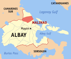
Malinao occupies a narrow stretch of plains hemmed in by Lagonoy Gulf in the east and Mount Malinao on the west. The area is dominated by the mountain ranges of Malinao, with a peak altitude of 1,584 metres (5,197 ft) above sea level. It is 30 kilometres (19 mi) from Legazpi City and 557 kilometres (346 mi) southeast of Manila.

Land use

  • Public land: 72.60 hectares (179.4 acres)
  • Built-up/Residential: 985.76 hectares (2,435.9 acres)
  • Agricultural: 5,750.34 hectares (14,209.4 acres)
  • Irrigable: 2,250 hectares (5,600 acres)
  • Irrigated: 1,873 hectares (4,630 acres)
  • Forest: 1,569.30 hectares (3,877.8 acres)
  • Timberland: 21.00 hectares (51.9 acres)
  • 2nd growth: 615.00 hectares (1,519.7 acres)
  • Watershed: 870.00 hectares (2,149.8 acres)
  • Mangrove/swamp: 63.30 hectares (156.4 acres)
  • Grassland/Shrub/Pasture: 15.00 hectares (37.1 acres)
  • Idle/Vacant lot: 49.00 hectares (121.1 acres)
  • Nipas: 2,308.00 hectares (5,703.2 acres)

Barangays

Malinao is politically subdivided into 29 barangays. [6] Each barangay consists of puroks and some have sitios.

Of these, 12 are upland barangays, 13 lowland barangays, and 4 are coastal barangays. Twenty-five barangays are rural areas and the remaining four are urban.

PSGC Barangay Population ±% p.a.
2020 [3] 2010 [7]
050510001 Awang 0.7% 347 336 0.32%
050510002 Bagatangki 1.6% 772 569 3.10%
050510022 Bagumbayan 1.7% 788 699 1.21%
050510003 Balading 6.5% 3,104 2,996 0.35%
050510004 Balza 4.4% 2,084 2,061 0.11%
050510005 Bariw 3.2% 1,524 1,353 1.20%
050510006 Baybay 3.7% 1,730 1,647 0.49%
050510007 Bulang 2.2% 1,028 864 1.75%
050510008 Burabod 1.8% 837 836 0.01%
050510009 Cabunturan 1.2% 577 681 −1.64%
050510010 Comun 3.7% 1,772 1,672 0.58%
050510011 Diaro 1.9% 889 885 0.05%
050510012 Estancia 9.1% 4,293 3,987 0.74%
050510013 Jonop 4.3% 2,024 2,009 0.07%
050510014 Labnig 7.3% 3,479 3,410 0.20%
050510015 Libod 2.2% 1,065 949 1.16%
050510016 Malolos 1.8% 856 785 0.87%
050510017 Matalipni 4.1% 1,939 1,863 0.40%
050510018 Ogob 4.2% 1,992 1,975 0.09%
050510019 Pawa 2.6% 1,217 1,103 0.99%
050510020 Payahan 3.0% 1,414 1,390 0.17%
050510021 Poblacion 1.4% 657 570 1.43%
050510023 Quinarabasahan 1.7% 821 735 1.11%
050510024 Santa Elena 2.4% 1,133 1,018 1.08%
050510025 Soa 2.9% 1,352 1,248 0.80%
050510026 Sugcad 3.8% 1,784 1,615 1.00%
050510027 Tagoytoy 4.9% 2,323 2,217 0.47%
050510028 Tanawan 3.7% 1,739 1,638 0.60%
050510029 Tuliw 3.7% 1,761 1,659 0.60%
Total47,39542,7701.03%

Climate

Climate data for Malinao, Albay
MonthJanFebMarAprMayJunJulAugSepOctNovDecYear
Average high °C (°F)27
(81)
27
(81)
28
(82)
30
(86)
31
(88)
30
(86)
29
(84)
29
(84)
29
(84)
29
(84)
28
(82)
27
(81)
29
(84)
Average low °C (°F)22
(72)
22
(72)
23
(73)
24
(75)
25
(77)
25
(77)
25
(77)
25
(77)
25
(77)
24
(75)
24
(75)
23
(73)
24
(75)
Average precipitation mm (inches)138
(5.4)
83
(3.3)
74
(2.9)
50
(2.0)
108
(4.3)
165
(6.5)
202
(8.0)
165
(6.5)
190
(7.5)
186
(7.3)
188
(7.4)
183
(7.2)
1,732
(68.3)
Average rainy days16.811.913.513.820.525.227.426.226.124.720.718.5245.3
Source: Meteoblue [8]

Demographics

Population census of Malinao
YearPop.±% p.a.
1903 12,437    
1918 13,539+0.57%
1939 15,089+0.52%
1948 15,176+0.06%
1960 16,926+0.91%
1970 22,978+3.10%
1975 24,889+1.62%
1980 28,372+2.65%
1990 31,349+1.00%
1995 33,872+1.46%
2000 36,231+1.45%
2007 39,516+1.20%
2010 42,770+2.92%
2015 45,301+1.10%
2020 47,395+0.89%
Source: Philippine Statistics Authority [9] [7] [10] [11]

In the 2020 census, Malinao had a population of 47,395. [3] The population density was 440 inhabitants per square kilometre (1,100/sq mi).

In 1995, The total population was 33,872, which increased by 2359 individuals or 6.94% for five (5) years in 2000. In the 2010 census, the population had reached 42,770.

Of these, less than ten (10) percent or 3,301 reside in the urban barangays of Bagumbayan, Pawa, Payahan, and Poblacion. The rest of the constituents meanwhile stay on the rural barangays: Awang, Bagatangki, Balading, Balza, Bariw, Baybay, Bulang, Burabod, Cabunturan, Comun, Diaro, Estancia, Jonop, Labnig, Libod, Malolos, matalipni, Ogob, Quinarabasahan, Santa Elena, Soa, Sugcad, Tagoytoy, Tanawan, and Tuliw. The densest areas are Estancia, Labnig, and Balading while Awang and Bagatangki are the least populated in the rural areas.

The majority of its population is engaged in agriculture and other agri-related enterprise.

Economy

The major agricultural products are:

Other crops:

Related Research Articles

<span class="mw-page-title-main">Guinobatan</span> Municipality in Albay, Philippines

Guinobatan, officially the Municipality of Guinobatan, is a 1st class municipality in the province of Albay, Philippines. According to the 2020 census, it has a population of 85,786 people.

<span class="mw-page-title-main">Claveria, Masbate</span> Municipality in Masbate, Philippines

Claveria, officially the Municipality of Claveria, is a 3rd class municipality in the province of Masbate, Philippines. According to the 2020 census, it has a population of 42,142 people. Ranked 592nd among 1,488 municipalities in the Philippines.

<span class="mw-page-title-main">Oas, Albay</span> Municipality in Albay, Philippines

Oas, officially the Municipality of Oas, is a 1st class municipality in the province of Albay, Philippines. According to the 2020 census, it has a population of 66,084 people.

<span class="mw-page-title-main">Madalag</span> Municipality in Aklan, Philippines

Madalag, officially the Municipality of Madalag, is a 4th class municipality in the province of Aklan, Philippines. It is Aklan's largest municipality by land area and also the most sparsely populated. According to the 2020 census, it has a population of 18,890 people.

<span class="mw-page-title-main">Bacacay</span> Municipality in Albay, Philippines

Bacacay, officially the Municipality of Bacacay, is a 2nd class municipality in the province of Albay, Philippines. According to the 2020 census, it has a population of 72,485 people. Bacacay is primarily an agricultural town and abundant in seafood.

<span class="mw-page-title-main">Camalig</span> Municipality in Albay, Philippines

Camalig, officially the Municipality of Camalig, is a 1st class municipality in the province of Albay, Philippines. According to the 2020 census, it had a population of 72,042 people. It is known for one of Bicol's finest delicacy, Pinangat.

<span class="mw-page-title-main">Daraga</span> Municipality in Albay, Philippines

Daraga, officially the Municipality of Daraga, is a 1st class municipality in the province of Albay, Philippines. According to the 2020 census, it has a population of 133,893.

<span class="mw-page-title-main">Libon, Albay</span> Municipality in Albay, Philippines

Libon, officially the Municipality of Libon, is a 1st class municipality in the province of Albay, Philippines. According to the 2020 census, it has a population of 75,073 people.

<span class="mw-page-title-main">Malilipot</span> Municipality in Albay, Philippines

Malilipot, officially the Municipality of Malilipot, is a 4th class municipality in the province of Albay, Philippines. According to the 2020 census, it has a population of 40,857 people.

<span class="mw-page-title-main">Manito, Albay</span> Municipality in Albay, Philippines

Manito, officially the Municipality of Manito, is a 4th class municipality in the province of Albay, Philippines. According to the 2020 census, it has a population of 26,162.

<span class="mw-page-title-main">Pio Duran</span> Municipality in Albay, Philippines

Pio Duran, officially the Municipality of Pio Duran, is a 3rd class municipality in the province of Albay, Philippines. According to the 2020 census, it has a population of 49,070 people.

<span class="mw-page-title-main">Santo Domingo, Albay</span> Municipality in Albay, Philippines

Santo Domingo, officially the Municipality of Santo Domingo,, is a 4th class municipality in the province of Albay, Philippines. According to the 2020 census, it has a population of 37,765 people.

<span class="mw-page-title-main">Tiwi, Albay</span> Municipality in Albay, Philippines

Tiwi, officially the Municipality of Tiwi is a 1st class municipality in the Province of Albay, Philippines. According to the 2020 census, it has a population of 56,444 people.

<span class="mw-page-title-main">Santa Elena, Camarines Norte</span> Municipality in Camarines Norte, Philippines

Santa Elena, officially the Municipality of Santa Elena, is a 3rd class municipality in the province of Camarines Norte, Philippines. According to the 2020 census, it has a population of 43,582 people.

<span class="mw-page-title-main">Caramoran</span> Municipality in Catanduanes, Philippines

Caramoran, officially the Municipality of Caramoran, is a 3rd class municipality in the province of Catanduanes, Philippines. According to the 2020 census, it has a population of 32,114 people.

<span class="mw-page-title-main">Donsol</span> Municipality in Sorsogon, Philippines

Donsol, officially the Municipality of Donsol, is a 3rd class municipality in the province of Sorsogon, Philippines. According to the 2020 census, it has a population of 50,281 people.

<span class="mw-page-title-main">Buhi, Camarines Sur</span> Municipality in Camarines Sur, Philippines

Buhi, officially the Municipality of Buhi, is a 1st class world class municipality in the province of Camarines Sur, Philippines. According to the 2020 census, it has a population of 81,306 people.

<span class="mw-page-title-main">Lagonoy</span> Municipality in Camarines Sur, Philippines

Lagonoy, officially the Municipality of Lagonoy, is a 2nd class municipality in the province of Camarines Sur, Philippines. According to the 2020 census, it has a population of 56,714 people.

<span class="mw-page-title-main">Minalabac</span> Municipality in Camarines Sur, Philippines

Minalabac, officially the Municipality of Minalabac, is a 2nd class municipality in the province of Camarines Sur, Philippines. According to the 2020 census, it has a population of 53,981 people.

<span class="mw-page-title-main">Tinambac</span> Municipality in Camarines Sur, Philippines

Tinambac, officially the Municipality of Tinambac, is a 1st class municipality in the province of Camarines Sur, Philippines. According to the 2020 census, it has a population of 70,176 people.

References

  1. Municipality of Malinao | (DILG)
  2. "2015 Census of Population, Report No. 3 – Population, Land Area, and Population Density" (PDF). Philippine Statistics Authority. Quezon City, Philippines. August 2016. ISSN   0117-1453. Archived (PDF) from the original on May 25, 2021. Retrieved July 16, 2021.
  3. 1 2 3 4 Census of Population (2020). "Region V (Bicol Region)". Total Population by Province, City, Municipality and Barangay. Philippine Statistics Authority . Retrieved 8 July 2021.
  4. "PSA Releases the 2018 Municipal and City Level Poverty Estimates". Philippine Statistics Authority. 15 December 2021. Retrieved 22 January 2022.
  5. "Province: Albay". PSGC Interactive. Quezon City, Philippines: Philippine Statistics Authority . Retrieved 12 November 2016.
  6. "Municipal: Malinao, Albay". PSGC Interactive. Quezon City, Philippines: Philippine Statistics Authority . Retrieved 8 January 2016.
  7. 1 2 Census of Population and Housing (2010). "Region V (Bicol Region)" (PDF). Total Population by Province, City, Municipality and Barangay. National Statistics Office . Retrieved 29 June 2016.
  8. "Malinao, Albay : Average Temperatures and Rainfall". Meteoblue. Retrieved 29 December 2018.
  9. Census of Population (2015). "Region V (Bicol Region)". Total Population by Province, City, Municipality and Barangay. Philippine Statistics Authority . Retrieved 20 June 2016.
  10. Censuses of Population (1903–2007). "Region V (Bicol Region)". Table 1. Population Enumerated in Various Censuses by Province/Highly Urbanized City: 1903 to 2007. National Statistics Office.
  11. "Province of Albay". Municipality Population Data. Local Water Utilities Administration Research Division. Retrieved 17 December 2016.
  12. "Poverty incidence (PI):". Philippine Statistics Authority. Retrieved December 28, 2020.
  13. "Estimation of Local Poverty in the Philippines" (PDF). Philippine Statistics Authority. 29 November 2005.
  14. "2003 City and Municipal Level Poverty Estimates" (PDF). Philippine Statistics Authority. 23 March 2009.
  15. "City and Municipal Level Poverty Estimates; 2006 and 2009" (PDF). Philippine Statistics Authority. 3 August 2012.
  16. "2012 Municipal and City Level Poverty Estimates" (PDF). Philippine Statistics Authority. 31 May 2016.
  17. "Municipal and City Level Small Area Poverty Estimates; 2009, 2012 and 2015". Philippine Statistics Authority. 10 July 2019.
  18. "PSA Releases the 2018 Municipal and City Level Poverty Estimates". Philippine Statistics Authority. 15 December 2021. Retrieved 22 January 2022.