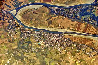
The Cagayan River, also known as the Río Grande de Cagayán, is the longest river and the largest river by discharge volume of water in the Philippines. It has a total length of approximately 505 kilometres (314 mi) and a drainage basin covering 27,753 square kilometres (10,715 sq mi). It is located in the Cagayan Valley region in northeastern part of Luzon Island and traverses the provinces of Nueva Vizcaya, Quirino, Isabela and Cagayan.

Aurora, officially the Province of Aurora, is a province in the Philippines located in the eastern part of Central Luzon region, facing the Philippine Sea. Its capital is Baler and borders, clockwise from the south, the provinces of Quezon, Bulacan, Nueva Ecija, Nueva Vizcaya, Quirino, and Isabela. Maria Aurora is the only landlocked town in the province and yet, the most populous. It is the only province in Central Luzon that has no chartered cities.

Isabela, officially the Province of Isabela, is the second largest province in the Philippines in land area located in the Cagayan Valley. Its capital and the largest local government unit is the city of Ilagan. It is bordered by the provinces of Cagayan to the north, Kalinga to the northwest, Mountain Province to the central-west, Ifugao and Nueva Vizcaya to the southwest, Quirino, Aurora and the independent city of Santiago to the south, and the Philippine Sea to the east.
Nueva Vizcaya, officially the Province of Nueva Vizcaya, is a landlocked province in the Philippines located in the Cagayan Valley region in Luzon. Its capital and largest town is Bayombong. It is bordered by Benguet to the west, Ifugao to the north, Isabela to the northeast, Quirino to the east, Aurora to the southeast, Nueva Ecija to the south, and Pangasinan to the southwest. Quirino province was created from Nueva Vizcaya in 1966.
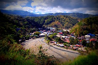
Aurora, officially the Municipality of Aurora, is a 2nd class municipality in the province of Isabela, Philippines. According to the 2020 census, it has a population of 36,621 people.

Delfin Albano, officially the Municipality of Delfin Albano, is a 4th class municipality in the province of Isabela, Philippines. According to the 2020 census, it has a population of 29,928 people.

Gamu, officially the Municipality of Gamu, is a 4th class municipality in the province of Isabela, Philippines. According to the 2020 census, it has a population of 30,655 people.
Mallig, officially the Municipality of Mallig, is a landlocked 4th class municipality in the province of Isabela, Philippines. The municipality has a land area of 133.40 square kilometers or 51.51 square miles which constitutes 1.07% of Isabela's total area. Its population as determined by the 2020 Census was 32,208.

Naguilian, officially the Municipality of Naguilian, is a 4th class municipality in the province of Isabela, Philippines. According to the 2020 census, it has a population of 33,788 people.

Quezon, officially the Municipality of Quezon, is a 4th class municipality in the province of Isabela, Philippines. According to the 2020 census, it has a population of 27,037 people.
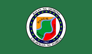
Quirino, officially the Municipality of Quirino, is a 4th class municipality in the province of Isabela, Philippines. According to the 2020 census, it has a population of 25,023 people.

Roxas, officially the Municipality of Roxas, is a 1st class municipality in the province of Isabela, Philippines. According to the 2020 census, it has a population of 65,839 people.

Santo Tomas, officially the Municipality of Santo Tomas, is a 4th class municipality in the province of Isabela, Philippines. According to the 2020 census, it has a population of 24,528 people.

Tumauini, officially the Municipality of Tumauini, is a 1st class municipality in the province of Isabela, Philippines. According to the 2020 census, it has a population of 70,743 people.
The legislative districts of Isabela are the representations of the province of Isabela and the independent component city of Santiago in the various national legislatures of the Philippines. The province and the city are currently represented in the lower house of the Congress of the Philippines through their first, second, third, fourth, fifth, and sixth congressional districts.

Santiago–Tuguegarao Road is a major national primary road in the provinces of Cagayan, Kalinga, and Isabela in the Philippines. It is a bypass road of the Pan-Philippine Highway, also known as Cagayan Valley Road, connecting to the cities of Tuguegarao and Santiago.

Isabela's 5th congressional district is one of the six congressional districts of the Philippines in the province of Isabela. It has been represented in the House of Representatives of the Philippines since 2019. The district consists of the municipalities of Aurora, Burgos, Luna, Mallig, Quezon, Quirino, Roxas, and San Manuel. It is currently represented in the 18th Congress by Faustino Michael Carlos T. Dy III of the Partido Federal ng Pilipinas (PFP), who has represented the district since its creation.

Isabela's 2nd congressional district is one of the six congressional districts of the Philippines in the province of Isabela. It has been represented in the House of Representatives since 1987. The district consists of the east-central municipalities of Benito Soliven, Gamu, Naguilian, Palanan, Reina Mercedes and San Mariano. It also consisted of the western municipalities of Aurora, Burgos, Mallig, Quezon, Quirino, Roxas, and San Manuel until the 2019 redistricting that incorporated Palanan and Reina Mercedes into the district. It is currently represented in the 18th Congress by Ed Christopher S. Go of Lakas–CMD.
Local elections were held in the province of Isabela on May 9, 2022, as part of the 2022 Philippine general election. Voters selected candidates for all local positions: a mayor, vice-mayor and councilors, as well as members of the Sangguniang Panlalawigan, the governor, vice-governor and for the six districts of Isabela for board members and congress.
