Malltraeth Marsh

Last updated

Malltraeth Marsh flatlands near the village of Pentre Berw The Malltraeth Marsh flatlands - geograph.org.uk - 877749.jpg
Malltraeth Marsh flatlands near the village of Pentre Berw

Malltraeth Marsh (also spelled as Malldraeth; Welsh : Cors Malltraeth or Cors Ddyga) is a large marsh area in Anglesey, North Wales, north-east of Malltraeth village, along the flatlands of Trefdraeth, Bodorgan, Llangristiolus and south of Cefn Cwmwd, Rhostrehwfa. It was reclaimed from estuarine marshes after the construction of the Malltraeth Cob (dyke), a 1 mile (1.6 km) long embankment, [1] and the subsequent canalisation in 1824 of the Afon Cefni. [2]

Contents

The name Malltraeth comes from mall ('bad'), and traeth ('sandy shore'). [3] The marsh measures 1,366.5 hectares (3,377 acres) in area. The area is recognised as a Site of Special Scientific Interest (SSSI), and has a range of reedbeds, marshes, wet grassland and small pools/lakes. [4]

History

Malltraeth Marsh and the Cefni flood embankment Malltraeth Marsh and the Cefni flood embankment - geograph.org.uk - 781610.jpg
Malltraeth Marsh and the Cefni flood embankment

In the Middle Ages the Malltraeth estuary was tidal, stretching as far inland as Llangefni and Ceint. [5]

In 1790, an act of Parliament was obtained for more effectually embanking the marshes called Malltraeth and Corsddeuga, under the provisions of which 93 hectares (230 acres) were allotted to the several proprietors of land in the parish of Llangaffo. [6] The 1,600 hectares (4,000 acres) of reclaimed alluvium at the mouth of the River Cefni subsequently underwent considerable improvements in the late-18th century and early-19th century with the introduction of embankments and flood mitigation measures. [7] During World War I, further improvements were made due to the concerns of farmers. However the reclamation became neglected and by the end of the war, it had fallen into a bad state and was subject to numerous heated conflicts between the drainage engineer, the CWAEC, and the underfunded catchment board managing the drainage of the marsh. [7] Bitter disputes over the marsh reached a climax with the chairman resigning from the Malltraeth Marsh and Cors Ddyga subcommittee in March 1942 and unusually high rainfall during the harvest in the following year devastating most of the cereal crops in the area. [7] Due to pressure from local farmers, Lord Anglesey met with Robert Hudson and Megan Lloyd George in 1944 to outline ideas for improving the local habitat. [7] Some £100,000 was allocated to developing what was about 50% derelict marsh during the war and by 1947, £147,000 had been spent on the scheme. [7]

The marsh near Morfa Brennin Malltraeth Marsh or Cors Ddyga near Morfa Brennin. - geograph.org.uk - 177498.jpg
The marsh near Morfa Brennin

Geography

Pool alongside the railway line on the Malltraeth Marsh Pool alongside the railway line on the Malltraeth Marsh - geograph.org.uk - 1458822.jpg
Pool alongside the railway line on the Malltraeth Marsh
View across Malltraeth Marsh towards Pen-y-Bont Farm View across Malltraeth Marsh towards Pen-y-Bont Farm - geograph.org.uk - 808877.jpg
View across Malltraeth Marsh towards Pen-y-Bont Farm

Located in the cwmwd of Malltraeth, [3] Cors Malltraeth Marsh is on the west side of the Afon Cefni valley which crosses Anglesey parallel to the Menai Straits, approximately 4 miles (6.4 km) to the north-west. [8] The habitat of Cors Ddyga on the east side of Afon Cefni has been reverted to wetlands and reeds. The wetland reserve is officially called RSPB Cors Ddyga. It consists of marshy grasslands, lakes, pools, fossiliferous coal and shales. [9]

The geology underlying both marshes, Cors Malltraeth and Cors Ddyga, is characterized by Carboniferous Limestone, millstone grit, soft coal measures shales, sandstone, coal seams, and Permian strata. [10] The Afon Cefni valley is 9 miles (14 km) long and runs almost exactly parallel to the valley of the Menai Strait.

Malltraeth Marsh is a wide and perfectly flat expanse of reedy pasture. An embanked tidal river runs through its midst, opening to Malltraeth Sands, 0.5 miles (0.80 km) to the southwest. A short tunnel, the first in Anglesey, pierces the low hills which extend along the west side of Malltraeth Marsh before reaching Bodorgan railway station. [11] Above Malltraeth lies the extensive common land of the marsh, which is bounded on the north-west by the parishes of Llangadwaladr, Trefdraeth, and Llangristiolus; on the northeast by Llangefni and Llanffinan. Cors Ddyga ("Tygai's marsh") lies in the commote of Rhosyr. It is on the east side of the Afon Cefni River or Afon Fawr Llanfihangel-y-Ceifiog, Llanidan, Llangaffo, Llangeinwen, and Newborough. [3]

Vegetation

The vegetation reported from the Malltraeth Marshand and Cors Ddyga consist of reed canary-grass, water-plantain, branched bur-reed, club rush and reed sweet-grass. Spiked water-milfoil, blunt-leaved pondweed, horned pondweed are also reported in the marsh land, apart from rare species of flowering rush, water-violet and marsh stitchwort. [9]

Fauna

European water voles inhabit the marsh. Birds such as northern lapwing, Eurasian curlew, common redshank and common snipe are reported from the lowland wet grassland. Eurasian teal, northern shoveller, gadwall and common pochard occupy the open water. [9] Other birds recorded are Eurasian bittern and grey heron. [9] Invertebrates include water beetles (Hydrochus brevis) and hairy dragonflies.

Conservation

Reclaimed farmland on the western edge of the Malltraeth Marsh Reclaimed farmland on the western edge of the Malltraeth Marsh - geograph.org.uk - 877746.jpg
Reclaimed farmland on the western edge of the Malltraeth Marsh

Malltraeth Marsh and Cors Ddyga is a Site of Special Scientific Interest (SSSI). The marshes are notable for their breeding bird community, lowland damp grassland, reedbeds, the threatened habitat of wet meadows, and the botanical importance of their ditches and watercourses. [12] A Royal Society for the Protection of Birds reserve is situated in the north-east corner of the SSSI. [4]

Management options undertaken to conserve the marshland consists of: maintaining water levels by proper upkeep of clay-lined ditches to conserve flora and fauna; maintaining an exclusive swamp area to breed bittern; creation of shallow water ditches along old water courses to drain large land areas where waders can feed; establishing water control structures on secondary drains to maintain high ground water table during the spring season; control of introduced invasive plant species such as fairy fern, Australian stonecrop and Himalayan balsam; reduce risk of predation (by predators such as crows and minks) of birds by constant conservation and preservation of hedges; encouraging grazing during the winter season and reducing it during summer to attract ground nestling birds, and controlled agricultural management to provide nestling sites for waders. [9]

Related Research Articles

<span class="mw-page-title-main">Llangefni</span> County town of Anglesey, Wales

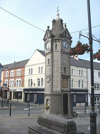
Llangefni is the county town of Anglesey in Wales and contains the principal offices of the Isle of Anglesey County Council. United Kingdom Census 2011 recorded Llangefni's population as 5,116 people, making it the second largest settlement in the county. The community includes the village of Rhosmeirch.

Newborough Warren near the village of Newborough (Niwbwrch) is a large dune and beach system of 2,269 hectares, approximately half of which is a conifer plantation. The whole area is designated as a Site of Special Scientific Interest and all of the site except the forestry is a national nature reserve.

<span class="mw-page-title-main">Isle of Anglesey County Council</span> Local government authority in north-west Wales

The Isle of Anglesey County Council is the local authority for the county of Anglesey, one of the principal areas of Wales. Since 2022 the council has 35 councillors who represent 11 multi-member electoral wards.

<span class="mw-page-title-main">Malltraeth</span> Village in Anglesey, Wales

Malltraeth is a small village in the southwest of Anglesey, in the community of Bodorgan. It is now at the end of a large bay, which used to extend much further inland, almost creating a second sea strait in the area. The population as of the 2011 census was only 255.

<span class="mw-page-title-main">Llyn Cefni</span> Body of water

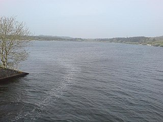
Llyn Cefni is a small reservoir in the centre of Anglesey, Wales which is managed by Welsh Water and Hamdden Ltd, while the fishery is managed by the Cefni Angling Association. The reservoir is located just 1 kilometre (0.6 mi) northwest of the island's county town of Llangefni.

<span class="mw-page-title-main">Afon Cefni</span> One of the major rivers on the island of Anglesey, Wales

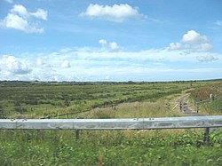
Afon Cefni is one of the major rivers on the island of Anglesey, Wales. It is 16.9 kilometres (11 mi) long. Its source is near to the village of Capel Coch, before flowing through Bodffordd and into Llyn Cefni in the centre of the island. It continues to run south through the county town of Llangefni. Just north of the A55 the river turns and flows south-west. It passes through the flatlands of the Malltraeth Marshes, where the river course was altered in 1824, creating a canal-like straight stretch. This part of the river and the surrounding marshes, part of which is a RSPB reserve, are frequented by a variety of wetland birds which in their turn are preyed on by falcons, hawks and harriers. A cycle trail follows the straightened course of the river as it flows through the marshes.

Pentre Berw is a small village located on the island of Anglesey in north Wales. It lies about 2 miles (3.2 km) south of the county town of Llangefni, and next to Gaerwen.

<span class="mw-page-title-main">Bodorgan</span> Village and community in Anglesey, Wales

Bodorgan is a village and community on the Isle of Anglesey, Wales, United Kingdom. According to the 2001 Census, there were 1,503 residents in the now former electoral ward, 72.7% of them being able to speak Welsh. This increased to 1,704 at the 2011 Census but only 67.72% of this increased population were Welsh speakers.

Grazing marsh is a British Isles term for flat, marshy grassland in polders. It consists of large grass fields separated by fresh or brackish ditches, and is often important for its wildlife.

<span class="mw-page-title-main">Anglesey</span> Island in Wales

Anglesey is an island off the north-west coast of Wales. It forms a principal area known as the Isle of Anglesey, that includes Holy Island across the narrow Cymyran Strait and some islets and skerries. Anglesey island, at 260 square miles (673 km2), is the largest in Wales, the seventh largest in Britain, largest in the Irish Sea and second most populous there after the Isle of Man. Isle of Anglesey County Council administers 276 square miles (715 km2), with a 2011 census population of 69,751, including 13,659 on Holy Island. The Menai Strait to the mainland is spanned by the Menai Suspension Bridge, designed by Thomas Telford in 1826, and the Britannia Bridge, built in 1850 and replaced in 1980. The largest town is Holyhead on Holy Island, whose ferry service with Ireland handles over two million passengers a year. The next largest is Llangefni, the county council seat. From 1974 to 1996 Anglesey was part of Gwynedd. Most full-time residents are habitual Welsh speakers. The Welsh name Ynys Môn is used for the UK Parliament and Senedd constituencies. The postcodes are LL58–LL78. It is also a historic county of Wales.

<span class="mw-page-title-main">Valley Wetlands</span> RSPB nature reserve in Anglesey, UK

Valley Wetlands, formerly Valley Lakes, is a nature reserve in Anglesey, Wales belonging to the Royal Society for the Protection of Birds. It is an area of lakes and reedbeds to the south-east of Valley in Llanfair-yn-Neubwll community, adjacent to RAF Valley airfield. The western section of the reserve includes Llyn Penrhyn, Llyn Treflesg and part of Llyn Dinam. The eastern part includes Llyn Traffwll and wetlands along the Afon Crigyll. Much of the reserve is included within two Sites of Special Scientific Interest.

<span class="mw-page-title-main">Anglesey Coalfield</span>

The Anglesey Coalfield is a minor British coalfield. Although it is situated in north-west Wales, this isolated coalfield on Anglesey is not usually considered to form a part of the North Wales Coalfield which lies in Flintshire and Denbighshire in north-east Wales although both measures were formed during the Carboniferous period. Stretching from Nant and Hirdrefaig in the Pentre Berw area along Cors Ddyga and under the sea at Malltraeth village which was called 'yr Iard' or 'Iard Malltraeth'. On the western side of the Afon Cefni lies Cors Malltraeth. It was named after Cwmwd Malltraeth (Commote) which was the old Welsh way of dividing the Isle of Mona by the Welsh Princes and the Church. Both coalfields measure around 9 miles long.

<span class="mw-page-title-main">St Ffinan's Church, Llanffinan</span> Church in Wales

St Ffinan's Church, Llanffinan is a small 19th-century parish church built in the Romanesque revival style, in Anglesey, north Wales. There has been a church in this area, even if not on this precise location, since at least 1254, and 19th-century writers state that St Ffinan established the first church here in the 7th century. The church was rebuilt in 1841, reusing a 12th-century font and 18th-century memorials, as well as the cross at the eastern end of the roof.

<span class="mw-page-title-main">Llangaffo</span> Village in Anglesey, Wales

Llangaffo is a village in Anglesey, in north-west Wales. It lies along the B4419 and B4421 roads, north of Dwyran, south of Gaerwen and northwest of Llanidan. It is named after Caffo, a 6th-century saint. A church, St Caffo's Church, is named after him. A war memorial, a village hall and a primary school are also located in the village. The 1851 census recorded 138 people in the village, 75 males, 63 females and a parish area of 1,590 acres (640 ha). It is in the community of Rhosyr. The 2011 census recorded a population of 357.

<span class="mw-page-title-main">Rhostrehwfa</span> Village in Anglesey, Wales

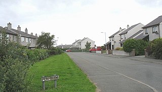
Rhostrehwfa is a village in southern-central Anglesey, located southwest of Llangefni. To the southeast is the Malltraeth Marsh. It is situated at a prominent point on the crest of a ridge overlooking the River Cefni valley to the south. It contains the Capel Pisgah and several holiday cottages. It is in the community of Llangristiolus and the Bodffordd electoral ward.

<span class="mw-page-title-main">St Beuno's Church, Trefdraeth</span> Church in Wales, UK

St Beuno's Church, Trefdraeth is the medieval parish church of Trefdraeth, a hamlet in Anglesey, north Wales. Although one 19th-century historian recorded that the first church on this location was reportedly established in about 616, no part of any 7th-century structure survives; the oldest parts of the present building date are from the 13th century. Alterations were made in subsequent centuries, but few of them during the 19th century, a time when many other churches in Anglesey were rebuilt or were restored.

<span class="mw-page-title-main">Llanfihangel Ysgeifiog</span> Community in Anglesey, Wales

Llanfihangel Ysgeifiog is a community and former ecclesiastical parish in Anglesey, Wales, east of Llangefni.

<span class="mw-page-title-main">Stodmarsh SSSI</span>

Stodmarsh SSSI is a 623.2-hectare (1,540-acre) biological Site of Special Scientific Interest near Stodmarsh, north-east of Canterbury in Kent. Parts of it are a Nature Conservation Review site, Grade I, a National Nature Reserve, a Ramsar internationally important wetland site, a Special Area of Conservation and a Special Protection Area under the European Union Directive on the Conservation of Wild Birds.

References

  1. "Welcome to the Malltraeth Ymlaen Frontpage". malltraeth.com. Retrieved 14 August 2011.
  2. "Malltreath Marsh/Cors Ddyga SSSI". angleseynature.co.uk. Retrieved 14 August 2011.
  3. 1 2 3 Carlisle, Nicholas (1811). A topographical dictionary of ... Wales, a continuation of the topography of the United Kingdom of Great Britain and Ireland (Now in the public domain. ed.). pp. 446–. Retrieved 13 August 2011.
  4. 1 2 "Malltraeth Marsh". rspb.org.uk. Retrieved 14 August 2011.
  5. Aris, Mary (2019), Rhosyr: Its History and Topography in the Age of the Welsh Princes, Matador, pp. 8–9, ISBN   978-1789016-673
  6. "LLANGAFFO". Genuki.org. Retrieved 13 August 2011.
  7. 1 2 3 4 5 Clout, Hugh D.; Munton, R. J. C. (2007). Contemporary rural geographies: land, property, and resources in Britain : essays in honour of Richard Munton. Routledge. p. 31. ISBN   978-0-415-43183-5 . Retrieved 14 August 2011.
  8. Woodward, Henry (1876). Geological It remains good grazing land compared with Cors Ddyga. landmagazine (Now in the public domain. ed.). Cambridge University Press. pp. 134–. Retrieved 13 August 2011.
  9. 1 2 3 4 5 "Malltraeth Marsh and Cors Ddyga, Site of Special Scientific Interest". Countryside Council for Wales. Retrieved 15 August 2011.
  10. The Assistant-Secretary of the Geological Society (1876). The Quarterly Journal of the Geological Society of London (Now in the public domain. ed.). pp. 120–. Retrieved 13 August 2011.
  11. Baddeley, Mounftord John Byrde (1884). North Wales (part 1) Chester, Rhyl, Llandudno, Bangor etc (Now in the public domain. ed.). Dulau & Co. pp. 95–. Retrieved 13 August 2011.
  12. "Anglesey Malltraeth Marsh / Cors Ddyga National Grid reference: SH440710". angleseynature.co.uk. Retrieved 14 August 2011.

Coordinates: 53°12′58″N4°19′59″W / 53.216°N 4.333°W / 53.216; -4.333