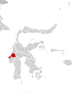
Mamuju Regency

Last updated
Mamuju Regency
Coat of Arms of Mamuju Regency.png
Motto(s): 
Manakarra
(A Sacred Land of Inheritance)
76.02.00 SulawesiBarat Mamuju.svg
Country Indonesia
Province West Sulawesi
Regency Mamuju
Government
  RegentSiti Sutina Suhardi
Area
  Total1,922.75 sq mi (4,979.89 km2)
Population
 (mid 2023 estimate) [1]
  Total292,395
  Density150/sq mi (59/km2)
Time zone UTC+8 (Indonesia Central Time)
Area code +62 426
Website mamujukab.go.id

Mamuju Regency is a regency (Indonesian : kabupaten Mamuju) of West Sulawesi province, Indonesia. The regency capital is at Karema, while Mamuju town is the capital of West Sulawesi. The population of the regency was 336,879 at the 2010 Census, [2] but it was substantially reduced by the creation of the new Central Mamuju Regency which was cut out of it on 14 December 2012. The reduced Mamuju Regency covers an area of 4,979.89 km2 and had a population of 278,764 at the 2020 Census; [3] the official estimate as at mid 2023 was 292,395 (comprising 149,395 males and 142,844 females). [1]

Contents

Uranium sites

Mamuju Regency has high potential uranium sites with radioactivity of ~250 nsv per year as same as at Pocos de Caldas, Brazil. The highest potential uranium site at hill of Takandeang village about 40 kilometers from Mamuju City has radioactivity 2,000-3,000 nsw per hour. [4]

Administration

The regency is divided into eleven districts (kecamatan), tabulated below with their areas and their populations at the 2010 Census [2] and 2020 Census, [3] together with the official estimates for mid 2023. [1] The table also includes the locations of the district administrative centres, the number of administrative villages in each district (totalling 88 rural desa and 14 urban kelurahan), and its post code.

Kode
Wilayah
Name of
District
(kecamatan)
Area
in
km2
Pop'n
Census
2010
Pop'n
Census
2020
Pop'n
Estimate
mid 2023
Admin
centre
No.
of
villages
Post
code
76.02.02Tapalang273.0218,08320,82021,624Galung10 (a)91551
76.02.13Tapalang Barat
(West Tapalang)
111.639,12911,79311,588Dungkait791552
76.02.01Mamuju (b)247.4855,10564,69667,575Binanga9 (c)91511 - 91515
76.02.12Simboro dan Kepulauan132.7323,20036,06339,517Rangas8 (d)91512 - 91513
76.02.16 Kepulauan Balabalakang (e)
(Balabalakang Islands)
1.482,3472,2012,244Pulau Salissingan
(Salissingan Island)
291512
76.02.03Kalukku (f)454.9649,25059,10862,134Kalukku14 (g)91561
76.02.07Papalang201.9221,39523,94224,662Topore991565
76.02.08 Sampaga 110.8313,98615,92516,487Bunde791563
76.02.11Tommo769.6619,40723,38124,606Campaloga1491564
76.02.04Kalumpang1,801.7110,80011,76312,022Kalumpang1391560
76.02.15Bonehau874.478,6229,4929,731Bonehau991562
Totals4,979.89(h)231,324278,764292,395Karema102

Notes: (a) including 3 kelurahan. (b) including offshore island of Pulau Karampuang to the north of the town. (c) including 5 kelurahan. (d) including 2 kelurahan.
(e) the Balabalakang Islands are a small group lying between West Sulawesi and East Kalimantan, and closer to the latter. (f) including 4 offshore islands.
(g) including 4 kelurahan. (h) excluding the 2010 population of those regencies split off in 2012 to form the new Central Mamuju Regency.

Related Research Articles

<span class="mw-page-title-main">West Sulawesi</span> Province of Indonesia

West Sulawesi is a province of Indonesia. It borders the provinces of South Sulawesi and Central Sulawesi to the east, Makassar Strait to the west, and the Pacific Ocean to the south. The province also shares maritime borders with East Kalimantan and South Kalimantan to the west and West Nusa Tenggara to the south. It is located on the western side of Sulawesi island. It covers a land area of 17,152.99 km2, and its capital is the town of Mamuju. The 2010 Census recorded a population of 1,158,651, while that in 2020 recorded 1,419,228; the official estimate as at mid 2023 was 1,481,077.

<span class="mw-page-title-main">Banggai Regency</span> Regency in Sulawesi, Indonesia

The Banggai Regency is a regency located at the eastern end of Central Sulawesi Province of Indonesia. It makes up a re-established regency (kabupaten), created on 4 October 1999 by splitting the existing Banggai Regency into this smaller Banggai Regency situated on the mainland of Sulawesi and a new Banggai Islands Regency comprising the offshore islands to the southeast which are separated from mainland Sulawesi by the Peleng Straits. The residual Banggai Regency covers an area of 9,672.70 km2 and had a population of 323,626 at the 2010 census and 362,275 at the 2020 census; the official estimate as at mid 2023 was 373,693.

<span class="mw-page-title-main">Selayar Islands Regency</span> Regency in Sulawesi, Indonesia

The Selayar Islands Regency is a regency of Indonesia in South Sulawesi province that covers the Selayar Islands, which lie southeast of the southern peninsula of Sulawesi. The archipelago consists of the group's main island, which is surrounded by 41 smaller islands around its coast; further to the southeast lies a widespread group of islands, including the smaller but still substantial islands of Pasimassunggu, Pasimarannu and Pasilambena in the far south, and the huge atoll of Takabonerate. The regency covers an area of 1,357.03 km2, and had a population of 103,596 at the 2000 Census, 122,055 at the Census of 2010 and 137,071 at that of 2020. The official estimate for mid 2023 was 142,100. The administrative centre is the town of Benteng on Selayar Island. The Selayar Straits separate the regency from Sulawesi island.

<span class="mw-page-title-main">Buol Regency</span> Administrative division in Central Sulawesi, Indonesia

Buol Regency is a regency of Central Sulawesi Province of Indonesia. It was created on 4 October 1999, having previously been the eastern half of a larger Buol Tolitoli Regency. It covers an area of 4,043.57 km2, and had a population of 132,330 at the 2010 Census; and 145,254 at the 2020 Census; the official estimate as at mid 2023 was 150,524. The administrative centre is the town of Buol, in Biau District.

<span class="mw-page-title-main">Polewali Mandar Regency</span> Regency in West Sulawesi, Indonesia

Polewali Mandar is one of the five regencies in West Sulawesi province of Indonesia. It borders on the regencies of Mamasa in the North, Majene in the West and Pinrang regency of South Sulawesi in the East. It covers an area of 2,074.76 km2 and had a population of 396,120 at the 2010 Census and 478,534 at the 2020 Census; the official estimate as at mid 2023 was 495,371. The regency is inhabited by various ethnic groups such as the Mandar, Buginese, Javanese and Toraja.

<span class="mw-page-title-main">Pinrang Regency</span> Regency in South Sulawesi, Indonesia

Pinrang Regency is one of the twenty-one regencies in South Sulawesi Province of Indonesia. Pinrang town in Watang Sawitto District is the administrative capital of Pinrang Regency. The regency is situated in the northwest of the South Sulawesi peninsula, and covers a land area of 1,896.57 km2. It had a population of 351,161 at the 2010 Census and 403,994 at the 2020 Census; the official estimate as at mid 2023 was 417,932.

<span class="mw-page-title-main">Siau Tagulandang Biaro Islands Regency</span> Regency in North Sulawesi, Indonesia

Sitaro Islands Regency is a regency located off the northern extremity of Sulawesi Island in the southern Sangihe Islands, North Sulawesi Province, Indonesia. The regency was formed under Law Number 15 Year 2007 from 2 January 2007, by separation from the Sangihe Islands Regency of which it had previously formed the southern part. The short form of the name is formed from one syllable from each of the names of the three principal islands — Siau, Tagulandang and Biaro.

<span class="mw-page-title-main">Pasangkayu Regency</span> Regency in West Sulawesi, Indonesia

Pasangkayu Regency is one of the six regencies which comprise West Sulawesi Province, Indonesia, on the island of Sulawesi. It covers an area of 3,043.75 km2 and had a population of 134,303 at the 2010 Census and 188,861 at the 2020 Census. The official estimate as at mid 2023 was 204,216. The town of Pasangkayu is the capital and chief town of the regency.

<span class="mw-page-title-main">Mamasa Regency</span> Regency in West Sulawesi, Indonesia

Mamasa Regency is one of the six regencies that make up the West Sulawesi Province, Indonesia, on the island of Sulawesi. It covers a land area of 3,005.88 km2. The population was 140,082 at the 2010 Census and 163,383 at the 2020 Census; the official estimate as at mid 2023 was 170,354. Its capital is the town of Mamasa. The Mamasa people - which is a sub-group of the Toraja people - form the most common ethnic group.

<span class="mw-page-title-main">Bombana Regency</span> Regency in Southeast Sulawesi, Indonesia

Bombana Regency is a regency of Southeast Sulawesi Province of Indonesia. It consists of part of the southeast peninsula of Sulawesi, together with most of the substantial offshore island of Kabaena to the south. The regency was created on 18 December 2003 from part of Buton Regency. It covers an area of 3,293.97 km2, and had a population on 139,235 at the 2010 Census and 150,706 at the 2020 Census; the official estimate as at mid 2023 was 163,402 - comprising 82,602 males and 80,800 females. The administrative centre lies at the town of Rumbia.

<span class="mw-page-title-main">Buton Regency</span> Regency in Southeast Sulawesi, Indonesia

Buton Regency is a regency of Indonesia's Southeast Sulawesi Province, lying entirely on Buton Island. Until 2014 it had an area of 2,681.22 km2, and a population estimated at 276,944. However, in 2014 it was divided into three regencies, with two new regencies being cut out of it; the residual area now is 1,647.87 km2, and the districts in that area contained a population of 94,388 at the 2010 Census while the 2020 Census produced a total of 115,207; the official estimate as at mid 2023 was 120,873 The capital is nominally at Pasarwajo, but the regency's administration is actually undertaken in the city of Baubau on the south-west of the island, although that city is administratively separate from the Regency.

<span class="mw-page-title-main">North Buton Regency</span> Regency in Southeast Sulawesi, Indonesia

North Buton Regency is a regency of Indonesia's Southeast Sulawesi Province, which was separated from Buton Regency in accordance with Indonesia's Law Number 14 of 2007. The area of the regency, which covers the north part of Buton Island, is 1,923.03 km2. Its population was 54,736 at the 2010 Census and 66,653 at the 2020 Census; the official estimate as at mid 2023 was 72,757. The administrative capital of the regency is at the town of Buranga, in Bonegunu District.

<span class="mw-page-title-main">Banggai Islands Regency</span> Regency in Sulawesi, Indonesia

The Banggai Archipelago is a group of islands, which are located at the far eastern end of Central Sulawesi, Indonesia. It makes up a regency (kabupaten) of Central Sulawesi Province of Indonesia, created on 4 October 1999 by splitting the existing Banggai Regency into a residual Banggai Regency situated on the mainland of Sulawesi and a new Banggai Islands Regency then comprising the entire archipelago. On 14 December 2012 a splitting of the Banggai Islands archipelago took place with the removal of the more southerly seven districts from the 13-year-old regency to form a separate Banggai Laut Regency.

<span class="mw-page-title-main">Tolitoli Regency</span> Regency in Central Sulawesi, Indonesia

Tolitoli Regency is a regency of Central Sulawesi Province of Indonesia. It was previously part of a larger Buol Tolitoli Regency, but this was split into two on 4 October 1999 after rapid decentralization of the Indonesian government. The present Tolitoli Regency covers an area of 3,701.54 km2 and had a population of 211,296 at the 2010 Census and 225,154 at the 2020 Census; the official estimate as at mid 2023 was 231,711, comprising 118,180 male and 113,530 female inhabitants. Its regency seat is located at the town of Tolitoli, which is a port town and where the regency's population is concentrated.

<span class="mw-page-title-main">North Minahasa Regency</span> Regency in North Sulawesi, Indonesia

North Minahasa Regency is a regency in North Sulawesi, Indonesia. Its capital is Airmadidi. It was originally part of the Minahasa Regency until it was split off and established as a separate regency on 20 November 2003. It covers an area of 1,059.24 km2, and had a population of 188,904 at the 2010 Census; this had risen to 224,993 at the 2020 Census, and the official estimate as at mid 2023 was 231,791. The Regency includes the offshore islands of Bangka and Talisei to the north of Sulawesi, and Mantenang and Naeng Besar to the northwest.

<span class="mw-page-title-main">Southeast Minahasa Regency</span> Regency in North Sulawesi, Indonesia

Southeast Minahasa Regency is a regency in North Sulawesi, Indonesia. It covers a land area of 730.63 km2, and had a population of 100,443 at the 2010 Census; this had risen to 116,323 at the 2020 Census, and the official estimate as at mid 2023 was 118,946. It was established as a separate regency from the south-eastern part of the South Minahasa Regency on 2 January 2007. Its administrative centre is at the town of Ratahan.

<span class="mw-page-title-main">Banggai Sea Regency</span> Regency in Central Sulawesi, Indonesia

Banggai Sea Regency is a regency in the province of Central Sulawesi, Indonesia. The regency was established on 14 December 2012, partitioned from the Banggai Islands Regency. It comprises the southern part of the Banggai Islands archipelago, including the main island of Banggai itself, the islands of Labobo and Bangkurung to the southwest of Banggai Island, and the numerous small Bokan Islands to the southeast; it does not include the larger island of Peleng to the north which forms the Banggai Islands Regency. The new Banggai Sea Regency covers a land area of 725.67 km2, and the districts now comprising the new Regency had a population of 62,183 at the 2010 Census and 70,435 at the 2020 Census; the official estimate as at mid 2023 was 73,100.

<span class="mw-page-title-main">West Muna Regency</span> Regency in Southeast Sulawesi, Indonesia

West Muna Regency is a new regency of Southeast Sulawesi Province of Indonesia,and is situated in the northwest corner of Muna Island and smaller ilsands of its coast. It was established under Act No.14 of 2014, dated 23 July 2014 by separation from the Muna Regency. It covers an area of 906.28 km2, and the districts comprising it had a population of 71,632 at the 2010 Census; the 2020 Census resulted in a population of 84,590, and the official estimate as at mid 2022 was 85,706, comprising 42,242 males and 43,464 females. The administrative centre lies at Laworo in the Tiworo Islands District.

<span class="mw-page-title-main">Central Buton Regency</span> Regency in Southeast Sulawesi, Indonesia

Central Buton Regency is a new regency of Southeast Sulawesi established by separation from Buton Regency under Act No.15 of 2014, dated 23 July 2014. It covers an area of 837.16 km2 comprising the southern parts of Muna Island and Kabaena Island, together with several small offshore islands adjacent to these two main islands, but with no territory located on Buton Island. It had a population of 86,112 at the 2010 Census and 114,773 at the 2020 Census; the official estimate as at mid 2023 was 121,369. The administrative centre lies at Labungkari in Lakudo District.

<span class="mw-page-title-main">South Buton Regency</span> Regency in Southeast Sulawesi, Indonesia

South Buton Regency is a regency located on Buton Island in Southeast Sulawesi Province of Indonesia. This regency was formed from the southern part of Buton Regency, from which it was separated by Act No.16 of 2014, dated 23 July 2014. It covers an area of 546.58 km2, and the population of the districts now comprising the new regency was 74,974 at the 2010 Census and 95,261 at the 2020 Census; the official estimate as at mid 2023 was 101,635. The regency capital is located in Batauga.

References

COLLECTIE TROPENMUSEUM De houten Kasiwah-brug bij de hoofdplaats Mamudju in Mandar is door een overstroming (banjir) stuk geslagen Celebes TMnr 10004447.jpg
  1. 1 2 3 Badan Pusat Statistik, Jakarta, 28 February 2024, Kabupaten Mamuju Dalam Angka 2024 (Katalog-BPS 1102001.7602)
  2. 1 2 Biro Pusat Statistik, Jakarta, 2011.
  3. 1 2 Badan Pusat Statistik, Jakarta, 2021.
  4. "Ada Uranium di Sulawesi Barat". March 17, 2012. Archived from the original on September 6, 2012. Retrieved March 17, 2012.

2°41′S118°54′E / 2.683°S 118.900°E / -2.683; 118.900