Burnet is a city in and the county seat of Burnet County, Texas, United States. The population was 5,987 at the 2010 census.

A Mediterranean climate or dry summer climate is characterized by dry summers and mild, wet winters. The climate receives its name from the Mediterranean Basin, where this climate type is most common. Mediterranean climate zones are typically located along the western sides of continents, between roughly 30 and 45 degrees north and south of the equator. The main cause of Mediterranean, or dry summer climate, is the subtropical ridge which extends northwards during the summer and migrates south during the winter due to increasing north-south temperature differences.

Climate change mitigation consists of actions to limit the magnitude or rate of global warming and its related effects. This generally involves reductions in human emissions of greenhouse gases (GHGs).
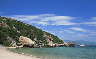
Cam Ranh is a city in southern Khánh Hòa Province, in the South Central Coast region of Vietnam.

The City of Ekurhuleni Metropolitan Municipality is a metropolitan municipality that forms the local government of the East Rand region of Gauteng, South Africa. The municipality itself is a large suburban region east of Johannesburg. The name Ekurhuleni means place of peace in XiTsonga. Ekurhuleni is one of the five districts of Gauteng province and one of the eight metropolitan municipalities of South Africa. The seat of Ekurhuleni is Germiston. The most common native language spoken by its 3.17 million people is IsiZulu, as of the 2001 Census. OR Tambo International Airport falls in the Kempton Park area of Ekurhuleni.

Energy in France is the energy and electricity production, consumption and import in France.

Karen Christiana Figueres Olsen is a Costa Rican diplomat with 35 years of experience in high level national and international policy and multilateral negotiations. She was appointed Executive Secretary of the UN Framework Convention on Climate Change (UNFCCC) in July 2010, six months after the failed COP15 in Copenhagen. During the next six years she worked to rebuild the global climate change negotiating process based on fairness, transparency and collaboration, leading to the 2015 Paris Agreement, widely recognized as a historical achievement.
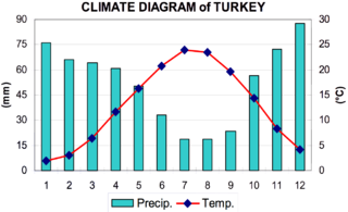
The coastal areas of Turkey bordering the Aegean Sea and the Mediterranean Sea have a hot-summer Mediterranean climate, with hot, dry summers and mild to cool, wet winters. The coastal areas of Turkey bordering the Black Sea have a temperate Oceanic climate with warm, wet summers and cool to cold, wet winters. The Turkish Black Sea coast receives the greatest amount of precipitation and is the only region of Turkey that receives high precipitation throughout the year. The eastern part of that coast averages 2,500 millimeters annually which is the highest precipitation in the country.
Sir Alan Walter Rudge CBE, FREng, FRS is a British electrical engineer. He was Chairman of the ERA Foundation from its formation until December 2012, after which he was appointed as the Foundation's President. In 2012 he also stepped down as Chairman of the Board of Management of the Royal Commission for the Exhibition of 1851, a position he had held for eleven years; he had succeeded Sir Denis Rooke and was himself succeeded by Bernard Taylor. He is a climate change denialist.
The renewable energy sector in Kenya is among the most active in Africa. In Kenya, investment grew from virtually zero in 2009 to US$1.3 billion in 2010 across technologies such as wind, geothermal, small-scale hydro and biofuels. This is not saying that Kenya was never active in the renewable energy sector. Kenya is Africa's first geothermal power producer and leads Africa in the number of solar power systems installed per capita. It is still the largest producer of geothermal power in Africa today at 200 MW with only one other African country producing geothermal power, Ethiopia.In 2011, Kenya was also the first country in Africa to open a carbon exchange.
Bleeding or flushing is shiny, black surface film of asphalt on the road surface caused by upward movement of asphalt in the pavement surface. Common causes of bleeding are too much asphalt in asphalt concrete, hot weather, low space air void content and quality of asphalt. Bleeding is a safety concern since it results in a very smooth surface, without the texture required to prevent hydroplaning. Road performance measures such as IRI cannot capture the existence of bleeding as it does not increase the surface roughness. But other performance measures such as PCI do include bleeding.
Melonguane is a town and district in Talaud Islands Regency in North Sulawesi province and it is the capital of the regency. Its population is 10463.
Balang is a village in Salibabu district, Talaud Islands Regency in North Sulawesi province. Its population is 592.
Sibualong is a village in Balaesang district, Donggala Regency in North Sulawesi province, Indonesia. Its population is 2437. Located about 1520 metres from the equator, it is the closest village in Sulawesi to the equator.
Tumbulawa is a village in Una-Una island, Central Sulawesi, Indonesia. Its population is 1226.
Popayato is a village in Popayato district, Pohuwato Regency in Gorontalo province. Its population is 978.
Walasiho is a village in Wawo district, North Kolaka Regency in Southeast Sulawesi province. Its population is 749.
Borimasunggu is a village in Labakkang district, Pangkajene and Islands Regency in South Sulawesi province. Its population is 3840.