Manajanabo | |
|---|---|
Town [1] | |
 Manajanabo (red) in Santa Clara (orange) in Villa Clara (yellow) | |
 Manajanabo 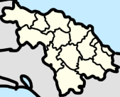 Manajanabo  Manajanabo | |
| Coordinates: 22°23′02″N79°49′01″W / 22.3839738°N 79.8169152°W | |
| Country | Cuba |
| Province | Villa Clara |
| Municipality | Santa Clara |
| Area | |
• Total | 0.452 km2 (0.175 sq mi) |
| Population (2012) [2] | |
• Total | 1,750 |
| • Density | 3,870/km2 (10,000/sq mi) |
| Postal Code | 50100 [3] |
Manajanabo is a town and ward ( consejo popular ) in Santa Clara, Cuba. Manajanabo lies on the Minerva Lake.