Tumbes is a coastal department and region in northwestern Peru bordering Ecuador. Due to the region's location near the Equator it has a warm climate, with beaches that are considered among the finest in Peru. Despite its small area, the region contains a wide variety of ecosystems. It is the smallest department in Peru and its third least populous department after Moquegua and Madre de Dios, but it is also its third most densely populated department, after La Libertad and Lambayeque.

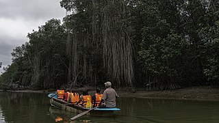
The Gulf of Guayaquil–Tumbes mangroves (NT1413) are an ecoregion located in the Gulf of Guayaquil in South America, in northern Peru and southern Ecuador. It has an area of 3,300 km².

Cerros de Amotape National Park is a protected area located in the regions of Piura and Tumbes in northern Peru.

Mangrove forests, also called mangrove swamps, mangrove thickets or mangals, are productive wetlands that occur in coastal intertidal zones. Mangrove forests grow mainly at tropical and subtropical latitudes because mangroves cannot withstand freezing temperatures. There are about 80 different species of mangroves, all of which grow in areas with low-oxygen soil, where slow-moving waters allow fine sediments to accumulate.
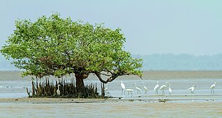
Coringa Wildlife Sanctuary is an estuary situated near Kakinada in Andhra Pradesh, India. It is the third largest stretch of mangrove forests in India with 24 mangrove tree species and more than 120 bird species. It is home to the critically endangered white-backed vulture and the long billed vulture. Mangroves are a group of trees and shrubs that live in the coastal intertidal zone, with a dense tangle of prop roots that make the trees appear to be standing on stilts above the water. This tangle of roots allows the trees to handle the daily rise and fall of tides; hence, the mangrove forest gets flooded at least twice per day. The roots also slow the movement of tidal waters, causing sediments to settle out of the water and build up the muddy bottom.
Iguanita Wildlife Refuge is a wildlife refuge, part of the Guanacaste Conservation Area. It is in Guanacaste Province, which is in northwestern Costa Rica.
Lagunas de Mejía National Sanctuary is a protected area on the coastal plain of Peru, in Islay Province, Arequipa, in the mouth of the Tambo River. It is a sanctuary for migratory and resident birds, and was designated a Ramsar site in 1992.

Ampay National Sanctuary is a wildlife sanctuary established in 1987. It is located in the district of Tamburco, just north of the city of Abancay, Peru. Its 36.35 square kilometres (14.03 sq mi), which include Mount Ampay, protect the Pachachaca River basin and several endangered plant species, being the most representative the conifer called Intimpa.
Tabaconas-Namballe National Sanctuary is a national sanctuary in Peru established in 1988, and protects the southernmost part of the páramo ecosystem. It is located in San Ignacio Province, Cajamarca and spans an area of 32,124.87 ha.
El Angolo is a game reserve in northern Peru. It is considered part of the Noroeste Biosphere Reserve, which includes Cerros de Amotape National Park and Tumbes National Reserve, as declared by UNESCO in 1977.
Tumbes National Reserve is a protected area established in 2006 and located in the region of Tumbes, Peru; near the border with Ecuador. It spans an area of 751 km2 (290 sq mi) and along with Cerros de Amotape National Park and El Angolo Game Preserve is part of the Noroeste Biosphere Reserve designated by UNESCO.

The New Guinea mangroves is a mangrove ecoregion that covers extensive areas of the coastline New Guinea, the large island in the western Pacific Ocean north of Australia.
Global mangrove distributions have fluctuated throughout human and geological history. The area covered by mangroves is influenced by a complex interaction between land position, rainfall hydrology, sea level, sedimentation, subsidence, storms and pest-predator relationships). In the last 50 years, human activities have strongly affected mangrove distributions, resulting in declines or expansions of worldwide mangrove area. Mangroves provide several important ‘free services’ including coastal stabilization, juvenile fish habitats, and the filtration of sediment and nutrients). Mangrove loss has important implications for coastal ecological systems and human communities dependent on healthy mangrove ecosystems. This article presents an overview of global mangrove forest biome trends in mangrove ecoregions distribution, as well as the cause of such changes.

The Sunda Shelf mangroves ecoregion, in the mangrove biome, are on the coasts of the islands of Borneo and eastern Sumatra in Malaysia and Indonesia. They are home to the proboscis monkey.

Nigeria has extensive mangrove forests in the coastal region of the Niger Delta. Considered one of the most ecologically sensitive regions in the world, the Niger Delta mangrove forest is situated within a deltaic depositional environment. These mangrove forests serve a critical role in regional ecological and landscape composition, and support subsistence gathering practices, and market-based income opportunities. Anthropogenic development threatens the survival of Niger Delta mangrove populations.

The Gulf of Panama mangroves (NT1414) is an ecoregion along the Pacific coast of Panama and Colombia. The mangroves experience seasonal flooding with high levels of sediment, and occasional extreme storms or very low rainfall due to El Niño effects. They are important as a breeding or nursery area for marine species. Areas of the mangroves have been recognized as Important Bird Areas and Ramsar wetlands. The ecoregion has been severely degraded by clearance of mangroves for agriculture, pasturage and shrimp farming, by urban pressure around Panama City, and by pollution related to the Panama Canal.

The Esmeraldas-Pacific Colombia mangroves (NT1409) is an ecoregion of mangrove forests along the Pacific coast of Colombia and Ecuador. It is threatened by human population growth, leading to over-exploitation for wood and clearance for farming and aquaculture.
The Manabí mangroves (NT1418) is an ecoregion along the Pacific coast of Ecuador. The mangroves serve important functions in the marine and terrestrial ecology. They have been severely degraded and fragmented, particularly in the northern region. Construction of shrimp farms caused much damage in the past, but is now banned. Sedimentation caused by overgrazing in higher lands is an issue, as are human activities such as port and highway construction, urbanization, waste disposal and so on.
Matapalo Island is an island located in the region of Tumbes, Peru in the Pacific Ocean. It is separated from the mainland by a strait 198 – 273 m wide, in east-west orientation. With a total area of 6.08 km², it is the biggest of the Peruvian islands in the Gulf of Guayaquil.