El Angolo Game Reserve

Last updated
El Angolo Game Reserve
Coto de Caza El Angolo
IUCN category VI (protected area with sustainable use of natural resources)
Peru physical map.svg
Red pog.svg
Location in Peru
LocationFlag of Peru.svg  Peru
Piura
Nearest city Sullana
Máncora
Coordinates 4°18′07″S80°47′47″W / 4.301865°S 80.79652°W / -4.301865; -80.79652
Area650 km2 (250 sq mi)
EstablishedJuly 1, 1975 (1975-July-01)
Governing body SERNANP
Website Coto de Caza El Angolo

El Angolo is a game reserve in northern Peru. It is considered part of the Noroeste Biosphere Reserve, which includes Cerros de Amotape National Park and Tumbes National Reserve, as declared by UNESCO in 1977. [1]

Contents

Geography

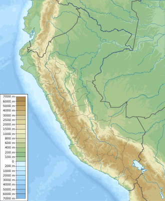
El Angolo Game Reserve spans an area of 65,000 hectares (650.00 km2) in the region of Piura, Peru. [2] Its elevational range goes from 200 to 1200 m above sea level. [2]

Climate

Temperatures in the reserve are between 15 °C and 39 °C, with a rainy season from December to April. [2] It is advisable to visit the area after the rainy season has finished. [2]

Ecology

Flora

El Angolo Game Reserve protects part of the seasonally dry tropical forests, an endangered ecosystem of which only 5% is under protection in Peru. [2] Among the plant species present in the area are: angolo ( Albizia multiflora),algarrobo ( Prosopis pallida ), ceibo ( Ceiba trischistandra), frejolillo ( Erythrina smithiana), overo ( Cordia lutea ), hualtaco ( Loxopterygium huasango), almendro ( Geoffroea spinosa), pasallo ( Eriotheca ruizii), palo santo ( Bursera graveolens ), cedro ( Cedrela sp.), Terminalia valverdeae, Ficus pertusa, etc. [2] [3] [4]

Fauna

The white-tailed deer is the only animal managed as game in this protected area. [2] [3] Mammals protected in the reserve include: the cougar, the jaguar, the puma, the northern tamandua, the Guayaquil squirrel, the Sechuran fox, etc. [2] [5] [6]

Among the birds reported in the area are: the Andean tinamou, the Pacific pygmy owl, the pale-browed tinamou, the king vulture, the Tumbes sparrow, the red-masked parakeet, the Andean condor, the great egret, the cocoi heron, the ochre-bellied dove, the long-billed starthroat, etc. [4] [7]

Activities

Trophy hunting is the main activity, with the hunting season being from May to November. [2] Hunting permits must be coordinated with the local hunting club (Club de Caza, Pesca, Turismo y Recreación de Piura), which manages the area together with the park's authorities. [2]

Other activities in the area are: birdwatching, hiking, fishing and scientific research. [2] [7]

Related Research Articles

<span class="mw-page-title-main">Geography of Peru</span>

Peru is a country on the central western coast of South America facing the Pacific Ocean. It lies wholly in the Southern Hemisphere, its northernmost extreme reaching to 1.8 minutes of latitude or about 3.3 kilometres (2.1 mi) south of the equator. Peru shares land borders with Ecuador, Colombia, Brazil, Bolivia, and Chile, with its longest land border shared with Brazil.

<span class="mw-page-title-main">Manú National Park</span> National park in Peru

Manú National Park is a national park and biosphere reserve located in the regions of Madre de Dios and Cusco in Peru. It protects a diverse number of ecosystems including lowland rainforests, cloud forests and Andean grasslands.

<span class="mw-page-title-main">Lachay National Reserve</span>

LachayNational Reserve is a protected area in the region of Lima, Peru. The reserve is located 105 kilometres (65 mi) north from the Peruvian capital, Lima, and protects part of the lomas ecosystem.

<span class="mw-page-title-main">Huascarán National Park</span> World Heritage Site and national park in Peru

Huascarán National Park is a Peruvian national park that comprises most of the mountain range known as Cordillera Blanca which is part of the central Andes, in the region of Ancash. The park covers an area of 340,000 hectares and is managed by the Peruvian Network of Protected Natural Areas, or SERNANP. It was designated as a World Heritage Site in 1985 by UNESCO, is also a well-known mountaineering spot, and harbors a unique biodiversity with plant species such as the Queen of the Andes, trees of the genera Polylepis and Buddleja, and animals such as spectacled bears, condors, vicunas, and tarucas.

<span class="mw-page-title-main">Cerros de Amotape National Park</span>

Cerros de Amotape National Park is a protected area located in the regions of Piura and Tumbes in northern Peru.

<span class="mw-page-title-main">Ampay National Sanctuary</span>

Ampay National Sanctuary is a wildlife sanctuary established in 1987. It is located in the district of Tamburco, just north of the city of Abancay, Peru. Its 36.35 square kilometres (14.03 sq mi), which include Mount Ampay, protect the Pachachaca River basin and several endangered plant species, being the most representative the conifer called Intimpa.

<span class="mw-page-title-main">Chacamarca Historic Sanctuary</span> Archaeological site in Peru

Chacamarca Historic Sanctuary, is a historical site in Junín Province, Junín, Peru. The sanctuary protects the site of the Battle of Junín and archaeological remains of the Pumpush culture.

Sunchubamba is a game reserve in the region of Cajamarca, Peru.

Laquipampa Wildlife Refuge is a protected area in the region of Lambayeque, Peru. It protects tropical dry forests, habitat of the white-winged guan and the spectacled bear.

Tumbes National Reserve is a protected area established in 2006 and located in the region of Tumbes, Peru; near the border with Ecuador. It spans an area of 751 km2 (290 sq mi) and along with Cerros de Amotape National Park and El Angolo Game Preserve is part of the Noroeste Biosphere Reserve designated by UNESCO.

<span class="mw-page-title-main">Pale-browed tinamou</span> Species of bird

The pale-browed tinamou is a type of tinamou found in tropical dry forests in Peru and Ecuador.

Marcavelica District is one of eight districts of the province Sullana in Peru. It was created by law on 25 March 1952 by the government of President Manuel A. Odría.

El Sira Communal Reserve is a protected area in Peru created to preserve the biodiversity of the Sira Mountains and the ancestral sustainable use of the area's resources by the nearby native peoples. It also protects the headwaters of the Pachitea river basin. The reserve covers an area of 616,413 hectares (6,164.13 km2) within the regions of Huánuco, Pasco and Ucayali. The reserve was created in 2001 and in 2010, UNESCO recognized it as part of the Oxapampa-Asháninka-Yánesha Biosphere Reserve.

<span class="mw-page-title-main">Allpahuayo-Mishana National Reserve</span>

Allpahuayo-Mishana National Reserve is a protected area in Peru located southwest of Iquitos in the region of Loreto. It was established in 2004 to protect the diverse forest types in the area, especially the rainforests on white sandy soil and watercourses which provide drinking water to the city of Iquitos.

<span class="mw-page-title-main">Bosque de Pómac Historic Sanctuary</span>

Bosque de Pómac Historic Sanctuary is a protected area in Peru located in the region of Lambayeque. This area preserves part of the Tumbes-Piura dry forests and several pyramids built by Pre-Columbian cultures.

Under UNESCO’s Man and the Biosphere Programme, there are 125 biosphere reserves recognized as part of the World Network of Biosphere Reserves in Latin America and the Caribbean. These are distributed across 21 countries in the region.

<span class="mw-page-title-main">Ecuadorian dry forests</span>

The Ecuadorian dry forests (NT0214) is an ecoregion near the Pacific coast of the Ecuador. The habitat has been occupied by people for centuries and has been severely damaged by deforestation, overgrazing and hillside erosion due to unsustainable agriculture. Only 1% of the original forest remains. The patches of forest, mostly secondary growth, are fragmented. They are home to many endemic species at risk of extinction.

<span class="mw-page-title-main">Tumbes–Piura dry forests</span>

The Tumbes–Piura dry forests (NT0232) is an arid tropical ecoregion along the Pacific coasts of southern Ecuador and northern Peru. The ecoregion contains many endemic species of flora and birds adapted to the short wet season followed by a long dry season. Threats include extraction of wood for fuel or furniture, and capture of wild birds for sale.

<span class="mw-page-title-main">Eastern Cordillera Real montane forests</span>

The Eastern Cordillera Real montane forests (NT0121) is an ecoregion in the eastern range of the Andes of southern Colombia, Ecuador and northern Peru. The ecoregion covers the eastern slopes of the Andes, and includes montane forest that rises from the Amazonian rain forest, with cloud forest and elfin forest at higher elevations. It is rich in species, including many endemics. It is threatened by logging and conversion for pasturage and subsistence agriculture.

References

  1. "Noroeste". UNESCO - MAB Biosphere Reserves Directory. Retrieved 2017-05-17.
  2. 1 2 3 4 5 6 7 8 9 10 11 "El Angolo - Servicio Nacional de Áreas Naturales Protegidas por el Estado". www.sernanp.gob.pe (in European Spanish). Retrieved 2017-05-12.
  3. 1 2 "COTO DE CAZA EL ANGOLO". Atractivos Turísticos (in Spanish). MINCETUR. Retrieved 2017-05-12.
  4. 1 2 "Coto de Caza El Angolo". BirdLife Data Zone. Retrieved 2017-05-17.
  5. Merrick, Melissa J.; Koprowski, John L.; Gwinn, R. Nathan (2012-01-25). "Sciurus stramineus (Rodentia: Sciuridae)". Mammalian Species. 44: 44–50. doi: 10.1644/894.1 . ISSN   0076-3519.
  6. Cossíos, E. Daniel (2010). "Lycalopex sechurae (Carnivora: Canidae)". Mammalian Species. 42 (848): 1–6. doi: 10.1644/848.1 . ISSN   0076-3519.
  7. 1 2 Barrio, J.; García-Olaechea, D.; More, A. (2015). "The avifauna of El Angolo Hunting Reserve, north-west Peru: natural history notes". Bulletin of the British Ornithologists' Club. 135 (1): 6–20.