Ramechhap District, a part of Bagmati Province, is one of the seventy-seven districts of Nepal, a landlocked country of South Asia. The district, known as wallo Kirat Ramechhap, with Manthali as its district headquarters, covers an area of 1,546 km2 (597 sq mi) and has a population (2011) of 202,646 and a density of 137.4 per km2.

Sindhuli District, a part of the Bagmati Province, is one of the seventy-seven districts of Nepal, a landlocked country of South Asia. The district, with Sindhulimadhi Kamalamai as its district headquarters and covers an area of 2,491 km2 (962 sq mi). As per the 2011 census, Sindhuli District has a population of 296,192.

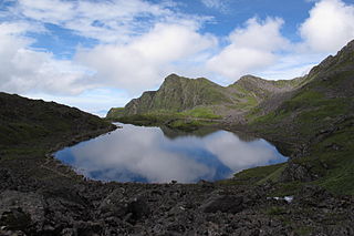
Sindhupalchok District is a part of Bagmati Province and one of the seventy-seven districts of Nepal, with an area of 2,542 km2 (981 sq mi). The district's headquarters is in Chautara. In 2006, 336,478 people resided in 79 village development committees, in 2011 there were 287,798.

Ilam is one of four urban municipalities of Ilam District, which lies in the Mahabharata hilly range of Province No. 1, eastern Nepal. Ilam also acts as the headquarters of Ilam District. Being the largest producer region for Nepali tea, its tea farms comprise a major tourist attraction in Province No. 1. Ilam is also famous for its natural scenery and landscapes as well as its diverse agricultural economy which specializes in horticultural crop production.

Bhimeshwar,, is a municipality in north-eastern Nepal and the headquarters of Dolakha District in Bagmati Province that was established in 1997 by merging the former Village development committees Charikot, Dolakha Town, Makaibari and Mati. At the time of the 2011 Nepal census it had a population of 32,486 people living in 8,639 individual households. The town is located at an altitude of 1554 metres (5101 feet). The name of the district Dolakha came from Dolakha Town situated north-east of the headquarters Charikot Bazaar.
Ramechhap Municipality is a municipality in Ramechhap District in Bagmati Province of Nepal. It was established on 2 December 2014 by merging the former village development committees Old-Ramechhap, Okhreni and Sukajor. At the time of the 2011 Nepal census it had a population of 28,612 people living in 6,126 individual households.
Lamatar is a village and former Village Development Committee that is now part of Mahalaxmi Municipality in Province No. 3 of central Nepal.
Solma is a village development committee in the Himalayas of Terhathum District in the Kosi Zone of eastern Nepal. At the time of the 1991 Nepal census it had a population of 4093 people living in 717 individual households. Solma is a Village Development Committee (VDC) lies on western part of Tehrathum District. The main ethnicity distribution of this VDC is Limbu (1190), Bramans (873), Kchhetri (663), Magar (381), Gurungs(287), Newar (166), Tamang (43) Kami (119)and Dam/Darji (100), Bhujel/Gharti (47). This VDC have one high school named Ratna Higher Secondary School, one Health Post, Post Office, Agriculture and Veterinary Center.

Padampur is a municipality in Chitwan District in the Narayani Zone of southern Nepal. At the time of the 1991 Nepal census it had a population of 8,884 people living in 1,559 individual households. It was transferred in new location named Saguntol by Government of Nepal and completed with in 8 years i.e. from 2050 BS to 2058 BS. Previously it was at the lap of Rapati river and inside the Chitwan National Park. Flood of Rapati river in monsoon season destroy farmers crops. Wild animals also harmed their crops. Transportation, electricity, road and educational facilities were beyond people's access. It was known as one of the remote areas of the Chitwan district. In a view of agriculture, It was the best place for farmers. After the new dawn of democracy in 2046, New government was asked to shift this village for peoples safety and conservation of forest and wild animal. The cabinet of Girija Prasad Koirala was assured to shift in a convenience place soon and started the task immediately. This task was successfully done by the politician Baburam Puri of the Nepali Congress. The late Sailaja Acharya visited the people and understood their griefs and proposed to shift it next to Sagoontol near Jutpani VDC. This was a very difficult task to accomplish successfully. People from the Western Chitwan were stood against it but government took bold decision in favour of people of Padampur. Now it is about 2.5 km (1.6 mi) east to Bharatpur, district headquarters of Chitwan. Electricity, roads and transportation facility are comparatively better here. 2,800 households were there now. According to the 2001 census, the total population of the VDC was 11,336 with total households 2,137. Tharus are the dominant ethnic group with 45.89% of the total VDC population. Brahman, Kshetri, Tamang, Gurung and Newar are other castes here. Mainly banana, maize and oil are farmed here. Except ward no 1 there are deep tubewells to Irrigate farmlands. Poultry, dairy, epiculture, mushroom farming and goat keeping have great potentials here. A campus, A higher secondary school, a secondary boarding school and other 7 primary and lower secondary schools are providing education here. Health post, and Post office are too doing their best for providing services to locals. Drinking water is provided in better and modern way. Pipelines of drinking water are available within all roads (113 km) of Padampur. An NGO veterinary office is also serving and helping farmers. Since last 5 years this VDC is starting to be known as one of pocket areas of commercial banana farming of the nation. Nobody is landless here and this is the special feature here. Padampur is very attractive location for migratory view and daily people are migrating here. It is like a colonial place for settlement of people. Government has sifted it in a well planned way and that is why it is the second model VDC of Nepal. Now this village has merged in Kalika Municipality and shares 4 wards in it i.e. Kalika -9, Kalika-10, Kalika-11 and Kalika-12.

Ramechhap Airport is a domestic airport serving the municipality of Manthali, the district headquarters of Ramechhap District located in the Tamakoshi River valley in Bagmati Province in Nepal. As of October 2022, most flights to Lukla Airport are operated from Ramechhap Airport.
Godawari is a municipality in Lalitpur District in Bagmati Province of Nepal. It was established on 2 December 2014 by merging the former Village development committees Godawari, Badikhel, Bisankhunarayan, Godamchaur and Thaiba of Lalitpur District of Bagmati Zone. The municipality area was again expanded in March 2017 to include in total 12 previous VDCs. The six VDCs added were Devichaur, Dukuchhap, Chhampi, Thecho, Chapagaun, Jharuwarasi and Lele. The centre of this municipality is located at Bajrabarahi.

Gandaki ProvinceListen (help·info)), is one of the seven federal provinces established by the current constitution of Nepal which was promulgated on 20 September 2015. Pokhara is the province's capital city. It borders the Tibet Autonomous Region of China to the north, Bagmati Province to the east, Karnali Province to the west, and Lumbini Province and Bihar of India to the south. The total area of the province is 21,504 km2 - about 14.57% of the country's total area. According to the latest census, the population of the province was 2,479,745. The newly elected Provincial Assembly adopted Gandaki Province as the permanent name by replacing its initial name Province no. 4 in July 2018. Krishna Chandra Nepali is the present chief minister of Gandaki Province.
Mahalaxmi is a municipality that lies in the north-eastern part of the Lalitpur district of Nepal. As per the declaration by the government of Nepal in 2015, it was created through the merger of the Village development committees Imadol, Lubhu, Tikathali, Siddhipur and Lamatar. The city derives its name from the Mahalaxmi-Mahabhairav Temple in Lubhu. The city's total area is 26.5 square kilometres. The municipality has a total number of 10 wards. The old VDC offices are used as joint ward office now.
Konjyosom Rural Municipality is a Rural Municipality in Lalitpur District in Bagmati Province of Nepal that was established in 2017 by merging the former Village development committees Sankhu, Dalchoki, Chaughare, Nallu and Bhardev.The center of this rural municipality is located at Chaughare. The major ethnic group of this rural municipality are Tamang. The name Konjyosom itself means Gautama Buddha in Tamang language.
Thuli Bheri is an urban municipality located in Dolpa District of Karnali Province of Nepal. The district headquarter of Dolpa lies in Dunai, which is a village in the south-east of Thuli Beri.
Umakunda is a Rural municipality located within the Ramechhap District of the Bagmati Province of Nepal. The municipality spans 451.99 square kilometres (174.51 sq mi) of area, with a total population of 17,601 according to a 2011 Nepal census.
Likhutamakoshi is a Rural municipality located within the Ramechhap District of the Bagmati Province of Nepal. The municipality spans 124.51 square kilometres (48.07 sq mi) of area, with a total population of 23,109 according to a 2011 Nepal census.
Doramba is a Rural municipality located within the Ramechhap District of the Bagmati Province of Nepal. The municipality spans 140.88 square kilometres (54.39 sq mi) of area, with a total population of 22,738 according to a 2011 Nepal census.
Khandadevi is a Rural municipality located within the Ramechhap District of the Bagmati Province of Nepal. The municipality spans 150.7 square kilometres (58.2 sq mi) of area, with a total population of 25,761 according to a 2011 Nepal census.
Sunapati is a Rural municipality located within the Ramechhap District of the Bagmati Province of Nepal. The municipality spans 86.98 square kilometres (33.58 sq mi) of area, with a total population of 18,141 according to a 2011 Nepal census.


