
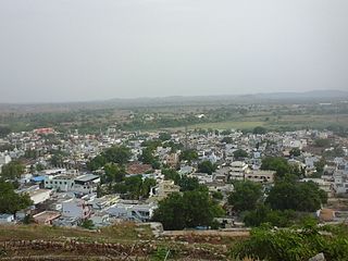
Kalaburagi, formerly known as Gulbarga, is a city in the Indian state of Karnataka. It is the administrative headquarters of the Kalaburagi district and is the largest city in the region of North Karnataka (Kalyana-Karnataka). Kalaburagi is 568 km north of the state capital city of Bangalore. It was incorporated into the newly formed Mysore State through the States Reorganisation Act in 1956.

Bijapur, officially known as Vijayapura, is the district headquarters of Bijapur district of the Karnataka state of India. It is also the headquarters for Bijapur Taluk. Bijapur city is well known for its historical monuments of architectural importance built during the rule of the Adil Shahi dynasty. It is also well known for the popular Karnataka premier league team, the Bijapur Bulls. Bijapur is located 519 km (322 mi) northwest of the state capital Bangalore and about 550 km (340 mi) from Mumbai and 210 km (130 mi) north east of the city of Belgaum.

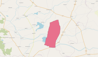
Raichur District is an administrative district in the Indian state of Karnataka. It is located in the northeast part of the state and is bounded by Yadgir district in the north, Bijapur and Bagalkot district in the northwest, Koppal district in the west, Bellary district in the south, Jogulamba Gadwal district of Telangana and Kurnool district of Andhra Pradesh in the east.

Kalaburagi district, formerly known as Gulbarga district, is one of the 31 districts of Karnataka state in southern India. Kalaburagi city is the administrative headquarters of the district. The district is the headquarters of Kalaburagi division.
Raichur is a city and municipality in the district of Raichur in the Indian state of Karnataka. Raichur, located between Krishna and Tungabhadra rivers, is the headquarters of Raichur district. It is located 410 km from the state capital, Bangalore.
Yadgiri is a city and the administrative headquarters of Yadgir district in the Indian state of Karnataka. It is also the administrative headquarters of Yadgir Taluka, one of the six taluks of Yadgir.
Harapanahalli is a city and a taluk in Vijayanagara District in the Indian state of Karnataka. It is the sub-division and administrative headquarters of the Harapanahalli Taluk.
Hutti Gold Mines, also spelled Hatti, is a notified area council in Raichur district in the Indian state of Karnataka. The mines are owned and operated by Hutti Gold Mines Limited.
Kushtagi is a panchayat town in Koppal district in the Indian state of Karnataka. Kushtagi is a taluk center of Koppal district. This taluk has a population of 353,142 as per the 2021 census estimate. In this taluk, pomegranate fruits are popularly grown.There is a Durga devi temple in heart of the town. To its North lies Ilkal, Gajendragad to the West, Hospet to the South and Sindhanur to the East. Red and black soil can be found in this taluk. A big lake 4kms away from the city is the main source of drinking water is situated in west side and covering the area of more than 300 acres.
Lingasugur is a municipal town in Raichur district in the Indian state of Karnataka. There are many Temples, hills and forts (Quila). The festivals of Muharram and Maha Shivaratri are important here. Mudgal in Lingasugur taluk has a very ancient fort. It has often been mentioned in the autobiography of Philip Meadows Taylor. Lingasugur, then known as Chavani was the site of a major British cantonment in the region.
Mudgal is a Municipal town in Lingsugur taluk, Raichur district in the Indian state of Karnataka. Mudgal is about 10 miles south-west of Lingsugur.
Siruguppa is a town and headquarters of the Siruguppa taluk and second largest city in Ballari district after Hospete carved out of Ballari district of Indian state of Karnataka.
Tekkalakote, also known as Tekkalakota, is a Panchayat town and Pre-historic Neolithic site in Siruguppa taluk of Ballari district in the Indian state of Karnataka.
Devadurga is a city in the sub-district (Taluka) within the Raichur district of the Indian state of Karnataka.
Gabbur also spelled as Gabburu is a village in the southern state of Karnataka, India. It is located in the Devadurga taluk of Raichur district in Karnataka.
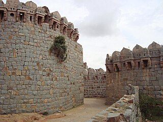
The Gulbarga Fort is located in Kalaburagi in the Kalaburagi district of North Karnataka. This fort was originally constructed by a hindu king Raja Gulchand, it was subsequently significantly enlarged in 1347 by Al-ud-din Hasan Bahmani of the Bahmani Dynasty after he cut off his ties with the Delhi Sultanate; Islamic monuments such as mosques, palaces, tombs, and other structures were also built later within the refurbished fort. The Jama Masjid built later, within the fort, in 1367, is a unique structure built in Persian architectural style, fully enclosed, with elegant domes and arched columns, which is unlike any other mosque in India. It was built to commemorate the establishment of the dynastic rule of the Bahmani kingdom at Kalaburagi fort between 1327 and 1424. It remained the capital of the Bahmani Kingdom till 1424 where after the capital was shifted to Bidar Fort, as Bidar had better climatic conditions.
Karatagi is a town and taluk headquarters of Karatagi taluk and it is located in Koppal District in Karnataka, India. It is one of the most important commercial centres in the district. The town is made up of multiple paddy fields, which are irrigated by the Tungabhadra Canal. Karatagi is known for its numerous rice mills, which can be found in the town and the surrounding areas.
Kapagal is a village in the Manvi taluk of Raichur district in the Indian state of Karnataka. Kapagal is well connected by road and it lies on Karnataka State highway 19. Kapagal is 8 km from Manvi and 40 km from District Headquarters Raichur. Nearest major railway station is in Raichur.
Raja Amareshwara Nayak is an Indian politician who is the current Member of Parliament in the Lok Sabha from Raichur, Karnataka in the 2019 Indian general election as member of the Bharatiya Janata Party.
Maladkal is a village in Karnataka state, comes under Raichur District, Devadurga Taluk and Gabbur hobli. Maladkal lies in northern part of Karnataka(Kalyana Karnataka Division). Maladkal shares its boundary with Gabbur, Ramadurga, Jagatakal, N Ganekal, Maseedpur and Atnur. Maladakal is one of the Gram Panchayat in Raichur District.
