
The Krishna River in the Deccan plateau is the third-longest river in India, after the Ganges and Godavari. It is also the fourth-largest in terms of water inflows and river basin area in India, after the Ganges, Indus and Godavari. The river, also called Krishnaveni, is 1,400 kilometres (870 mi) long and its length in Maharashtra is 282 kilometres. It is a major source of irrigation in the Indian states of Maharashtra, Karnataka, Telangana and Andhra Pradesh.

Raichur District is an administrative district in the Indian state of Karnataka. It is located in the northeast part of the state and is bounded by Yadgir district in the north, Bijapur and Bagalkot district in the northwest, Koppal district in the west, Bellary district in the south, Jogulamba Gadwal district of Telangana and Kurnool district of Andhra Pradesh in the east.

The Tungabhadra River starts and flows through the state of Karnataka, India, during most of its course, then through Andhra Pradesh, and ultimately joins the Krishna River near Murvakonda in Andhra Pradesh.

The Bhima River is a major river in Western India and South India. It flows southeast for 861 kilometres (535 mi) through Maharashtra, Karnataka, and Telangana states, before joining the Krishna River. After the first sixty-five kilometers in a narrow valley through rugged terrain, the banks open up and form a fertile agricultural area which is densely populated.

The Kabini River (Kapila River) is one of the major tributaries of the river Cauvery in southern India, It originates near Kavilumpara in Kozhikode district of Kerala state by the confluence of the Panamaram River and the Mananthavady River. It flows eastward through Wayanad district, entering Mysore district of Karnataka, to join the Kaveri River in Mysore district of Karnataka.
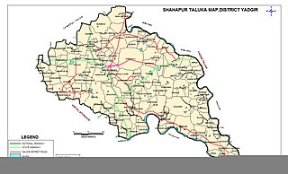
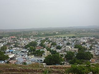
Shahapur is a city and taluka headquarter located in the Yadgir district of Indian state of Karnataka. Shahapur is 597 km north of Bangalore and well connected by road to Gulbarga (70 km), Hyderabad (240 km), Bidar (160 km), Raichur (90 km) and Yadgir (32 km).

North Karnataka is a geographical region in Deccan plateau from 300 to 730 metres elevation that constitutes the region of the Karnataka state in India and the region consists of 14 districts. It is drained by the Krishna River and its tributaries the Bhima, Ghataprabha, Malaprabha, and Tungabhadra. North Karnataka lies within the Deccan thorn scrub forests ecoregion, which extends north into eastern Maharashtra.
Yadgiri is a city and the administrative headquarters of Yadgir district in the Indian state of Karnataka. It is also the administrative headquarters of Yadgir Taluka, one of the six taluks of Yadgir.

Chikkodi is a town, taluka and one of three Subdivisional headquarter, in the Belagavi district of Karnataka, India. Chikodi, Athani, Hukkeri, Raybag, Nipani and Kagwad are the taluks that come under Chikodi Subdivision. It is 75 kilometers from the city of Belgaum, 65 kilometers from Kolhapur, 51 kilometers from Miraj, 160 kilometers from Hubli, and 570 kilometers from the capital of Karnataka state, Bangalore. Chikodi has many district level offices but it is not designated as a district by the Government of Karnataka. It is one of the major cities that lies in the border between Karnataka and Maharashtra states.
Lingasugur is a municipal town in Raichur district in the Indian state of Karnataka. There are many Temples, hills and forts (Quila). The festivals of Muharram and Maha Shivaratri are important here. Mudgal in Lingasugur taluk has a very ancient fort. It has often been mentioned in the autobiography of Philip Meadows Taylor. Lingasugur, then known as Chavani was the site of a major British cantonment in the region.
Shaktinagar is a town in Raichur taluk and Raichur district in the Indian state of Karnataka. There is a coal-based thermal power plant operated by Vst Gang Limited (vgl).

Tirumakudalu Narasipura the temple city of Karnataka, commonly known as T. Narasipura or T.N. Pura, is a town in Mysore district in the Indian state of Karnataka. The first name refers to the land at the confluence, (trimakuta in Sanskrit at the confluence of the Kaveri, Kabini and Spatika Sarovara. The city is a Taluk of Mysore district and 32 km south-east of the district headquarters and has five Hobli centers. This taluk is bordered by Chamarajanagar district to the south and Mandya districts to the north with an area of 598 sq km. Agriculture is the main occupation of the people here. Rice is the main food crop and silk is the main commercial crop. Fossils of Neolithic age have been found by excavation in some lands of this Taluk. Vyasatirtha, the guru of Purandara Dasa, and T Chowdiah, the unique violinist, were born in this Taluk. Talakad, the capital of the Western Ganga dynasty, is in this Taluk.

Karnataka, the sixth largest state in India, has been ranked as the third most popular state in the country for tourism in 2014. It is home to 507 of the 3600 centrally protected monuments in India, second only to Uttar Pradesh. The State Directorate of Archaeology and Museums protects an additional 752 monuments and another 25,000 monuments are yet to receive protection.

Athani is a town in the Belagavi district of Karnataka, India. It is 140 kilometers from the city of Belagavi, 70 kilometers from Vijayapura, 55 kilometers from Miraj, 100 kilometers from Kolhapur, and 624 kilometers from Bengaluru.

Jaladurga is a fortified village in Raichur district in the Indian state of Karnataka, about 20 km (12 mi) northeast of Lingsugur town. The Adil Shahi Kings of Bijapur built the fort.
Gandhinagar formerly known as Jalihal Camp, is one of the largest villages in Karnataka state in terms of area, population, property, agricultural production and revenue. It is the first government recognized revenue village in the Tunga Bhadra Delta Region. From 17 May 1997 onward, this village was renamed Gandhi Nagar from Jalihal Camp. is located on either sides of Tunga bhadra left Bank Canal,#36. In this village, there are many fertile, high-yielding paddy fields. Paddy is the main agricultural crop in the Tunga Bhadra Delta Region and the paddy varieties grown here include: Sonamasuri, Emergency, Ganga Kaveri, Nellore Sona, JJL, RS22.

Nava Brindavana ;, is located on an island in the Tungabhadra River at Anegundi, near Hampi, Karnataka, India. The Brindavanas of nine Hindu Madhva saints present in Nava Brindavana belongs to [ Nanjangudu Sri Raghvandra swami math] and Uttaradi Math, Vyasaraja Math and Raghavendra Math. All these saints are descended from Padmanabha Tirtha, direct disciple of Jagadguru Madhvacharya.
Mukkunda is a village in the Sindhanur taluk of the Raichur district in Karnataka, India. It is located on the banks of the Tungabhadra river. Mukkunda has several ancient temples, including the Sri Rama mandir shri dhurgamma temple, the Murari Ranga, and the Baajeshwara. The Tungabhadra river surrounds an Eshwara temple built in Hoysala style during the Sindha dynasty. A Sufi saint, hazrat gadde Khadar Bhasha darga Mukkunda is well known, and many visitors from surrounding village will come to take the blessings of this saint. It is and 27 km from Karnataka State Highway 19. The nearest towns are Siruguppa and Karatagi. Mukkunda is well known for its Krishna temple.
Googal sometimes spelled as Google is a village in the Devadurga taluk of Raichur district in Karnataka state, India. Googal is located on the banks of Krishna River. Googal is famous for its cave temple dedicated to Allama Prabhu. Legend has it that Googal derives its name from kooguva kallu, rocks that produce sound when river water strikes them. Googal is 50 km from district headquarters Raichur, and lies in Northwest direction.
National Highway 167, is a national highway in India, which was formed as a new National Highway by up-gradation and passes through the states of Karnataka, Telangana and Andhra Pradesh. It starts at Hagari in Karnataka and ends at Kodad in Telangana. It is a secondary route of National Highway 67.

