Maps of the Lands of the House of Orange

Last updated

Coats of arms corresponding to the titles borne by various Dutch monarchs, including Veere and Flushing (right above the bottom crowned arms), displayed at Nieuwe Kerk in Amsterdam Amsterdam wapenbord.JPG
Coats of arms corresponding to the titles borne by various Dutch monarchs, including Veere and Flushing (right above the bottom crowned arms), displayed at Nieuwe Kerk in Amsterdam

Besides being sovereign over the principality of Orange Oranje wapen.svg , this is a partial listing of larger estates and titles that William the Silent and his heirs possessed, most enfeoffed to some other sovereign, either the King of France, the Habsburgs, or the States of the provinces of the Netherlands [1]

Contents

Style of the Dutch sovereign:

Dietz Dietz wapen.svg , Vianden Graafschap Vianden.svg , Buren Buren wapen klein.svg , Moers Graafschap Meurs wapen.svg , Leerdam Leerdam wapen.svg , and Culemborg (1748) Coat of arms of Culemborg.svg

Cranendonck Cranendonk heerlijkheidswapen.svg , Lands of Cuijk Coat of arms of Cuijk.svg , Eindhoven Eindhoven wapen.svg , City of Grave Coat of arms of Grave.svg , Lek Heerlijkheid Van de Lek.svg , IJsselstein IJsselstein wapen.svg , Acquoy Acqoy wapen.svg , Diest Armoiries d'Isembourg.svg , Grimbergen Blason Grimbergen.svg / Grimbergen, van wapen.svg , Herstal Herstal wapen.svg , Warneton (Waasten (nl)) Waasten baronie wapen.svg , Beilstein Beilstein wapen.svg , Bentheim-Lingen DEU Grafschaft Lingen COA.svg , Arlay Blason ville fr Arlay (Jura).svg Blason gueules-bande or.svg , Nozeroy Blason Nozeroy.svg , and Orpierre Orpierre wapen.svg ;

Bredevoort Bredevoort wapen oud 6.svg , Dasburg DEU Dasburg COA.svg , Geertruidenberg Geertruidenberg wapen.svg , Hooge en Lage Zwaluwe Hoge-Lage-Zwaluwe-wapen.svg , Klundert Klundert wapen.svg , 't Loo Blason vide 3D 600x660.svg , Montfort, Blason ville nl Montfort(Limburg).svg Naaldwijk Naaldwijk wapen.PNG , Niervaart, Polanen/lands of Polanen Blason Jean II de Wassenaer, Seigneur de la Lecke (selon Gelre).svg , Steenbergen Steenbergen gemeentewapen.svg , Sint-Maartensdijk Sint Maartensdijk wapen.svg , Turnhout Turnhout wapen2.svg & Zevenbergen Blason ville nl Zevenbergen.svg , Willemstad Willemstad wapen.svg , Bütgenbach BE Buetgenbach COA.svg , Sankt Vith BE Sankt Vith COA.svg , and Besançon Blason-diocese-Besancon-ancien.svg

Maps of Lands

Sovereign Titles

King of the Netherlands

NameTimespanMapCoat of ArmsHistoric Map
King of the Netherlands

Koning der Nederlanden
1815–present

-The monarch of the Netherlands is constitutionally always considered "king" to ensure the powers are continuous.

Netherlands location map.svg
Green pog.svg
Amsterdam (Capital & largest city)
Amsterdam (Capital & largest city) (Netherlands)
Koninklijk wapen van het koninkrijk der Nederlanden.svg
Royal Arms since 1907
KonDerNed-10-10-10.png

Principality of Orange

The original main title was taken from the Principality of Orange on the Rhone River outside Avignon and the papal lands of the Comtat Venaissin. The principality was 108 sq mi (280 km2). However, the prince was a sovereign monarch, which put him on the same plane as the kings and monarchs of Europe and the world. This is much the same situation as Monaco today.

NameTimespanMapCoat of ArmsHistoric Map
Prince of Orange

Prince d'Orange
793?/885 - 1713
titular 1713-present

- Founded by First House of Orange- 885
- Imperial immediacy 1163 as a principality in the Holy Roman Empire
- Completely sovereign as Holy Roman Empire retreated from the Kingdom of Burgundy approx. 1254
- Ceded to France by the Treaty of Utrecht 1713

France location map-Regions and departements-2016.svg
Green pog.svg
Orange
Orange (France)
T12 Furst.svg
Arms of the Principality of Orange.svg
Principality of Orange
Principality of Orange (1633).png
Lord of Aumelas

Seigneur de Aumelas
- 1544 - 1795
-The Lordship of Aumelas was part of the titles of the first Counts of Orange, but not part of the sovereign principality.
Languedoc-Roussillon-Midi-Pyrenees region location map.svg
Green pog.svg
Aumelas
Aumelas (Occitanie)
Rangkronen-Fig. 37.svg
Blason ville fr Aumelas (Herault).svg
Map commune FR insee code 34016.png
Map of Aumelas

Grand Duke of Luxembourg (1815-1890)

NameTimespanMapCoat of ArmsHistoric Map
Grand Duke of Luxembourg

Groussherzog vu Lëtzebuerg
Grand-duc de Luxembourg
1815 - 1890

-The Grand Duchy was setup as an associated part of the German Confederation in 1815, but ruled by the King of the Netherlands.
-In the founding of the Belgian state in 1830-1831 the status of Luxembourg was at issue. It was repartitioned with the predominantly Germanic/Luxembourgish part remaining as the independent Grand Duchy.
-When William III of the Netherlands died in 1890 without a male heir, the next heir by the pact of the Nassau Family was Adolph of Nassau-Weilburg, the former Duke of Nassau, who was installed as Grand Duke.

Luxembourg adm location map.svg
Green pog.svg
Luxembourg City (Capital & largest city)
Luxembourg City (Capital & largest city) (Luxembourg)
Greater coat of arms of the grand-duchy of Luxembourg.svg
Grand Ducal Arms
LuxembourgPartitionsMap english.png
Partitions of Luxembourg
Duke of Limburg

Hertog van Limburg
1839 - 1867
-The Duchy was setup as originally as provinces of the United Kingdom of the Netherlands (1815-1830) and an associated part of the German Confederation in 1815, but ruled by the King of the Netherlands and consolidating several older states, including the Duchy of Limburg/Hertogdom Limburg.

-In the founding of the Belgian state in 1830-1831 the status of Luxembourg and Limburg was at issue. Along with Luxembourg being partitioned, the Dutch thus created the Duchy of Limburg (consisting of the Province of Limburg minus its two major cities, Maastricht and Venlo).
-After 1890, Limburg was considered an integral part of the Netherlands.

-The style "Duchy of Limburg" continued to be used in some official capacities until February 1907. An idiosyncrasy that survives to this day is that the King's Commissioner for the province is still informally addressed as "Governor" in Limburg, although his formal style does not differ from that used in other provinces.
Netherlands location map.svg
Green pog.svg
Roermond
Roermond (Netherlands)
T11 Erbherzog.svg
Modern Arms of Limburg.svg
Ducal Arms
Verenigd Koninkrijk der Nederlanden (tot 1830).png
The Exchange of 1839. The removal of Western Luxembourg (4) from the German customs union by Belgium (3) resulted in compensation by the Netherlands (1) by the creation of the Duchy of Limburg (2) (this territory was controlled by Belgium until 1839).

Germany

Ancestral Lands

Initially, the family was known as “of Nassau” after their oldest possession the County of Nassau and their part of the subdivision of the lands, the Countship of Nassau-Dillenburg. This was divided and subdivided amongst the descendants of John the Elder. It generally comprised the northern part of the entire county of Nassau, north of the Lahn River. It was reunited in the 18th century under the line of Nassau-Dietz.

NameTimespanMapCoat of ArmsHistoric Map
Princely County of Nassau
(Ancestral Estate of the House of Nassau , Imperial Immediate Estate)
Gefürstete Grafschaft Nassau
specifically Count of Nassau in Dillenburg, Siegen, Dietz, Hadamar, Beilstein, which were all subdivisions of Nassau.
915 - 1866

- Founded and Acquired by the Lords of Laurenburg 915 – 1125
- Imperial immediacy 1093, on the death of the last Duke of Franconia
- Raised to Princely County 1664
- Lost in the Austrian-Prussian War, 1866

Germany adm location map.svg
Green pog.svg
Nassau
Nassau (Germany)
Princely Hat.svg
Arms of Nassau.svg
Count of Nassau
Mitteleuropa zur Zeit der Staufer.svg
Nassau (light yellow) within the HRE during the rule of the Staufers. The Rhine is light blue line to the left.

Subdivisions of Nassau

These subdivisions (baronies and lordships) of Nassau were split into semi-autonomous countships and pricipalities for the younger members of the House of Nassau. The title for these was Count of Nassau in xyz.

Lands of House of Nassau in Germany
Nassau-totaal.png
House of Nassau (Walramian and Ottonian) Lands in and around Nassau in 1789
1789 House of Orange-Nassau possessions in Germany.png
Close up of House of Orange-Nassau (Ottonian) Lands in and around Nassau in 1789
House of Nassau Lands in and around Nassau. After John VI the Elder of Nassau-Dillenburg died in 1606, Nassau-Dillenburg was divided among his five surviving sons (see genealogical table above, House of Nassau-Dillenburg): William Louis received a reduced Nassau-Dillenburg, George received Nassau-Beilstein, and John VII the Middle received Nassau-Siegen.
NameTimespanMapCoat of ArmsHistoric Map
Count of Nassau in Dillenburg

Barony of Dillenburg
Graf von Nassau in Dillenburg, und Herr und Baron von Dillenburg

1254-1805

-Ancestral seat of the Royal House of the Netherlands.
-Dillenburg Castle was built on top of the peak now called the Schlossberg in the late 13th or early 14th century
-Usually a seat of the elder line of the Ottonian Nassaus.
-Last broken off in 1504 for "William the Rich", father of William the Silent and his younger brother "John the Elder". It went John in 1544 when William went to the Netherlands to claim the inheritance of the Nassau-Breda line as Prince of Orange.

-Confiscated by Napoleon in Favor of the Confederation of the Rhine/Grand Duchy of Berg.
Germany adm location map.svg
Green pog.svg
Dillenburg
Dillenburg (Germany)
Rangkronen-Fig. 18.svg
Nassau-Dillenburg 1559-1739.svg
The Counts of Nassau in Dillenburg to 1739
DEU Dillenburg COA.svg
Civic Arms
Nassau1547.jpg
Dillenburg in Nassau 1547
County of Diez or Dietz
Grafschaft Diez or Dietz
-Probably created as a successor to the original county of the Conradines in Niederlahngau.

-In 1388 part passed via his daughter Jutta to his son-in-law, Adolf I, Count of Nassau-Siegen.
-In 1564, Nassau-Dillenburg and the Electorate of Hesse split the county.

-The House of Nassau created a new county of Nassau-Dietz in 1606, from which the current royal family of the Netherlands is descended. The Monarchs of the Netherlands still claim this as part of their title
Germany adm location map.svg
Green pog.svg
Diez
Diez (Germany)
Rangkronen-Fig. 18.svg
Dietz wapen.svg
Count of Diez
Mitteleuropa zur Zeit der Staufer.svg
Diez (brown) to the west of bordering/almost surrounded by Nassau (light yellow) within the HRE during the rule of the Staufers. The northern half of Katzenellenbogen is in orange just below Diez. The Rhine is light blue line to the left.
Count of Nassau in Siegen

Barony of Siegen
Graf von Nassau in Siegen, und Herr und Baron von Siegen

1303-1328/1606-1743

-After John VII died in 1628, the country was divided: his eldest son, John VIII, who had converted to Catholicism, received the part of the county south of the river Sieg. John Maurice, who remained Protestant, received the part of the county north of the Sieg.
-In 1743, Nassau-Siegen had died out in the male line, and the territory fell to Prince William IV of the Orange-Nassau-Dietz line, who thereby reunited all the lands of the Ottonian line of the House of Nassau.

-The principality consisted of the districts of Siegen, Netphen, Hilchenbach, and Freudenberg. From 1628-1734, the Protestant part consisted of the districts of Hilchenbach and Freudenberg and a half the district of Siegen. At the time, the Catholic half of the district of Siegen was called the district of Hayn. The Catholic part of the county consisted of the district of Netphen and the other half of the district of Siegen.
Germany adm location map.svg
Green pog.svg
Siegen
Siegen (Germany)
Rangkronen-Fig. 18.svg
Nassau-Dillenburg 1559-1739.svg
The Counts of Nassau in Siegen to 1679
Rangkronen-Fig. 18.svg
Nassau Siegen et.svg
Counts of Nassau in Siegen to 1743
Wappen Siegen.svg
Civic Arms
Blaeu 1645 - Nassovia Comitatus.jpg
The baronies and lordships of Nassau by Blaeu in 1645
Count of Nassau in Beilstein

Barony of Beilstein
Herr und Baron von Beilstein

- Founded 1129

-Acquired by Otto I around 1287

-Usually a seat of a younger line of the Ottonian Nassaus
Germany adm location map.svg
Green pog.svg
Nassau-Beilstein
Nassau-Beilstein (Germany)
Rangkronen-Fig. 18.svg
Beilstein wapen.svg
Lord and Baron of Beilstein
Blaeu 1645 - Nassovia Comitatus.jpg
The baronies and lordships of Nassau by Blaeu in 1645
Count of Nassau in Hadamar

Barony of Hadamar
Herr und Baron von Hadamar

1620-1743
-Seat of a younger line of the Ottonian Nassaus, starting with John Louis
Germany adm location map.svg
Green pog.svg
Nassau-Hadamar
Nassau-Hadamar (Germany)
Rangkronen-Fig. 18.svg
Nassau-Dillenburg 1559-1739.svg
Lord and Baron of Hadamar
Blaeu 1645 - Nassovia Comitatus.jpg
The baronies and lordships of Nassau by Blaeu in 1645
Count of Nassau in Schaumburg

County of Holzappel, Lordship of Schaumburg
Grafschaft Holzappel, Heerschaft von Schaumburg (Schloss Schaumburg)

1643–1692

-In 1643, the Lordship of Esterau along with the bailiwick of Isselbach was purchased by Imperial Field Marshal Peter Melander, Count of Holzappel (1641), from John Louis of Nassau-Hadamar, who was in considerable financial difficulty. Emperor Ferdinand III raised the Lordship to the Imperial County of Holzappel. [2]
-The territory of the Lordship of Schaumburg consisted of Biebrich, Cramberg and Steinsberg. [3]
-His only child Elisabeth Charlotte, Countess of Holzappel married Adolph,Count of Nassau-Dillenburg who took the title of Nassau-Schaumburg.

-Elisabeth Charlotte left Holzappel to the youngest of her three daughters, Charlotte of Nassau-Schaumburg, who married Lebrecht of Anhalt-Dernburg in 1692, a cadet line of the princely house of Anhalt-Bernburg, the Princes of Anhalt-Bernburg-Schaumburg-Hoym.
Germany adm location map.svg
Green pog.svg
Schaumburg
Schaumburg (Germany)
Rangkronen-Fig. 18.svg
Arms Nassau-Schaumburg.svg
Lord and Baron of Schaumburg

Other German Lands

Additionally, the House of Nassau acquired other lands in and around their ancestral estates:

NameTimespanMapCoat of ArmsHistoric Map
County of Katzenelnbogen (claimed)
Grafschaft Katzenelnbogen
- Founded and Acquired by Diether I as Vogt of Abby of Prüm Abbey
-In 1479, the male line of the Katzenelnbogens became extinct. The Obergrafschaft was passed to the Landgraves of Hesse by virtue of the 1458 marriage of Henry III of Upper Hesse to Count Philipp's daughter Anna of Katzenelnbogen
-The counts of Nassau also claimed Katzenellenbogen, and the Monarchs of the Netherlands still claim this as part of their title
Germany adm location map.svg
Green pog.svg
Katzenelnbogen
Katzenelnbogen (Germany)
Rangkronen-Fig. 18.svg
Katzenelnbogen wapen klein.svg
Count of Katzenellenbogen
Grafschaft Katzenelnbogen 1400.png
County of Lingen
Grafschaft Lingen
- Founded 1180 under Henry the Lion and Frederick Barbarossa.

-Acquired by House of Tecklenburg-Schwerin, 1388
-Conquered 1597 by Maurice of Nassau

-After William III's death in 1702 was inherited by the Hohenzollern
Germany adm location map.svg
Green pog.svg
Lingen
Lingen (Germany)
Rangkronen-Fig. 18.svg
DEU Grafschaft Lingen COA.svg
Count of Lingen
Locator County of Lingen (1560).svg
County of Moers
Graafschap Meurs
-
-1186, independent principality

-During the Eighty Years' War it was alternately captured by Spanish and Dutch troops,
- During the war it finally fell to Maurice of Orange.
-It did not become an integral part of the Republic, though Dutch troops were stationed there.

-After the death of William III of Orange in 1702, Moers was inherited by the king of Prussia.
Germany adm location map.svg
Green pog.svg
Moers
Moers (Germany)
Rangkronen-Fig. 18.svg
Graafschap Meurs wapen.svg
Count of Meurs
HRR 1648 (cropped- County of Moers).png
County of Spiegelberg
Grafschap van Spiegelberg
-1631 - 1819

-abt 1200, for Counts of Poppenburg

-Inherited by Nassau-Diez in 1631
-Sold to King of Hannover in 1819.
Germany adm location map.svg
Green pog.svg
Spiegelberg
Spiegelberg (Germany)
Rangkronen-Fig. 18.svg
Graafschap Spiegelberg wapen.svg
Count of Spiegelberg
Locator County of Spiegelberg (1560).svg

Other Paternal Estates of the Royal House

Once the House of Nassau acceded to the royal throne, the Queens married with these representatives of other royal houses:

NameMarriedMapCoat of ArmsHistoric Map
Grand Duchy of Mecklenburg -Schwerin Queen Wilhelmina m. Duke Henry of Mecklenburg-Schwerin Arms of Hendrik of Mecklenburg-Schwerin.svg

Queen Juliana

Germany adm location map.svg
Green pog.svg
Schwerin
Schwerin (Germany)
T09 Herzog.svg
Wappen Mecklenburg-Schwerin 2.svg
Mecklenburg-Schwerin in the German Reich (1871).svg
Grand Duchy of Mecklenburg-Schwerin within the German Empire
Principality of Lippe -Beisterfeld Queen Juliana m. Prince Bernhard of Lippe-Biesterfeld Arms of Bernhard of Lippe-Biesterfeld.svg

Queen Beatrix

Germany adm location map.svg
Green pog.svg
Detmold, Lippe
Detmold, Lippe (Germany)
Princely Hat.svg
Lippe-Schwalenberg wapen.svg
Lippe in the German Reich (1871).svg
Principality of Lippe within the German Empire

Lippe.png

Amsberg Queen Beatrix m. Claus von Amsberg Arms of Claus von Amsberg.svg

King Willem-Alexander

N/A Rangkronen-Fig. 37.svg
Arms of the Von Amsberg Family.svg
N/A

The Netherlands

Most of the estates of the family were in the Netherlands in the more populous provinces of northern Brabant, southern Holland, and Zealand, around the delta of the Rhine/Scheldt/Maas rivers, the trading center made by them, and its entrance to the sea. The land itself was secondary to the profit on the commerce that flowed through it and the political influence that accrued with them (see Western Netherlands Commercial Center which developed into Amsterdam Trading Center, which later developed into the Dutch Randstad.).

The family properties in the Netherlands centered around the Barony of Breda. The barony sat on the delta of the Rhine in northwestern Brabant. Before the revolt the main residence of the family outside the Nassau Palace in Brussels was the castle and fortress of Breda. It was as also relatively close to their important function of Viscount of Antwerp. This fortress withstood several sieges during the 80 years war if the Dutch Revolt, but is most famous for being captured in 1624 by the Spanish as immortalized by Velazquez.

The county of Vianden sat high above a tributary of the Moselle that flowed into the trade routes of the Rhine into western Germany and the Netherlands. In the 12th to 15th centuries the counts of Vianden were the mightiest lords of the area between the rivers Rhine, Mosel and Maas. Their territory was in modern Vianden canton, Luxemburg and Bitburg-Prüm, Germany.

William the Silent married as his first wife Anna van Egmont heiress of Maximiliaan van Egmond, Count of Buren. This also included the counties of Leerdam and Lingen. While these lands devolved to Anna's son Philip William, as he died without heirs, they devolved to the prince of Orange. The hier/eldest son of the prince of Orange was titled “Count of Buren”. It remains one of the subsidiary titles of the Dutch Monarch.

Northern Netherlands/later the Dutch Republic & the Kingdom of the Netherlands

These counties, baronies and lordships are in the official titulature of the monarch of the Netherlands:

NameFromTimespanMapCoat of ArmsHistoric Map
Barony of Breda

Baronie van Breda
in Brabant/Staats-Brabant
Van Polanen family 1403 – now
- The center of all the Orange-Nassau lands in the Netherlands
- 1350 sold by Duke of Brabant to John I, Lord of Polanen, the van Polanens were a cadet of the van Wassenaers
- Engelbert I of Nassau married Johanna van Polanen in 1403, making the House of Nassau a large landowner in the Netherlands for the first time.
- one of the titles of the Monarch of the Netherlands is still "Baron of Breda", Breda heerlijkheidswapen.svg
Benelux location map.svg
Green pog.svg
Breda
Breda (Benelux)
Rangkronen-Fig. 27.svg
Blason ville be Schoten.svg
HRR 1400.png
HRR 1400.png
The Barony of Breda in 1400 in dark green as part of the Duchy of Brabant in light green.

Nieuwe en beknopte hand-atlas - 1754 - UB Radboud Uni Nijmegen - 209718609 033 Baronie van Breda.jpeg
The barony of Breda in northern Brabant in 1645.

Lord of Polanen Van Polanen family 1403 – now
-van Polanen en Polanen Castle (near Monster) & Duivenvoorde Castle

-2x Baron: van Breda (see above) and van Herstal Herstal wapen.svg
-7x heer: van lordship of den Lek Heerlijkheid Van de Lek.svg , van Geertruidenberg Geertruidenberg wapen.svg , van de Niervaart & van de Klundert Klundert wapen.svg , van Montfoort bij Heeswijk? [4] Montfoort wapen.svg , van Naaldwijk Naaldwijk gemeentewapen.svg ,

en van Steenbergen Steenbergen gemeentewapen.svg
Benelux location map.svg
Green pog.svg
Polanen
Red pog.svg
Duivenvoorde
Blue pog.svg
de Lek
Gold pog.svg
barony of Herstal
Orange pog.svg
Geertruidenberg
Purple pog.svg
Niervaart/Klundert
Yellow pog.svg
Montfoort
Red pog.svg
Naaldwijk
Red pog.svg
Steenbergen
Maps of the Lands of the House of Orange (Benelux)
Rangkronen-Fig. 27.svg
Blason Jean II de Wassenaer, Seigneur de la Lecke (selon Gelre).svg
Blaeu 1645 - Krimpenerwaard Heerlijkheid de Lek.jpg

Map of the heerlijkheid van de Lek from van Blaeu 1645.
It covered the villages of Lekkerkerk, Krimpen aan de Lek, Krimpen aan den IJssel, Ouderkerk aan den IJssel, Berkenwoude and Stormpolder, and possibly Nieuw-Lekkerland.

Geertruidenberg 1649 Blaeu.jpg
Geertruidenberg

County of Buren

Graafschap Buren
in Gelderland
Egmond-Buren 1395 - now

- Inherited by the Egmonds.
- 1498 made a county.
- Inherited by Nassau Family when William the Silent married Anna van Egmont in 1551
Benelux location map.svg
Green pog.svg
Buren
Buren (Benelux)
Buren wapen 1818.svg Buren-Blaeu-1665-2.jpg
The county of Buren in 1665 south of the Lek branch of the Rhine.
The County of Leerdam

Graafschap van Leerdamin Utrecht
Egmond-Buren c.1279 - now

- formed a part of the Vijfheerenlanden domain,
-raised County in 1498.
- in 1551, inherited by Nassau Family with Acquoy when William the Silent married Anna van Egmont in 1551.
Benelux location map.svg
Green pog.svg
Leerdam
Leerdam (Benelux)
Leerdam wapen.svg
Arms of Leerdam with the arms of the Count of Leerdam on the lefthand lion.
Historische kaart Vijfheerenlanden (16e eeuw).jpg
Leerdam in the 16th century
The County of Culemborg

Graafschap van Culemborg in Gelderland
awarded by States of Gelderland1748 - 1795

- Given to William IV by the States of Gelderland
- Arms of Culemborg Family Van Culemborg family CoA.svg

Benelux location map.svg
Green pog.svg
Culemborg
Culemborg (Benelux)
Rangkronen-Fig. 18.svg
Coat of arms of Culemborg.svg
Arms of Counts of Culemborg
Culenburg-Blaeu-1665.jpg
County of Culemborg in the 17th century

NL - locator map municipality code GM0216 (2016).png
Municipality today

Barony and city of IJsselstein

Baronie IJsselstein
in Utrecht
Egmond-Buren c.1279 - now

- created for the Van Amstel family.
- in 1363 inherited by the Inherited by Egmonds.
- Inherited by Nassau Family when William the Silent married Anna van Egmont in 1551.
Benelux location map.svg
Green pog.svg
IJsselstein
IJsselstein (Benelux)
Rangkronen-Fig. 27.svg
Die heer van Yselstein.svg
Yselstein 1649 Blaeu 1 van 4.jpg
1649 map of IJsselstein in Willem and Joan Blaeu's "Toonneel der Steden"
Lordship and barony of Cranendonck

Heerschap en baronie van Cranendonck
in Brabant/Staats-Brabant
Egmond-Buren
1072 - 1795

- First mentioned 1223, as Castle Cranendonck, inherited by William van Cranendonck.
- inherited by families Van Sevenborn, Van Milberg, Van Schoonvorst, Van Horne and Van Egmond.

- 1551 inherited by Oranges when William the Silent married Anna van Edmond.
Benelux location map.svg
Green pog.svg
Cranendonk
Cranendonk (Benelux)
Rangkronen-Fig. 27.svg
Cranendonk heerlijkheidswapen.svg
NL - locator map municipality code GM1706 (2016).png
Lordship and barony of Einhoven

Heerschap en baronie van Eindhoven
in Brabant/Staats-Brabant
Egmond-Buren
1100 - 1795

- Motte and Bailey castle in 1100. In 1232, Eindhoven was still in the possession of Duke Henry II of Brabant, but the manor of Eindhoven was probably given to Willem, lord of Cranendonck, in 1282.
- inherited by various families. The manor was then sold in 1483 to Frederik van Egmont. In 1521 he was succeeded by his son Floris van Egmont, and then his son Maximilian of Egmont in 1539. This went with his daughter Anna of Egmont when she married William of Orange in 1551. Their son was Philip Willem,became lord of Eindhoven in 1558 after the death of his mother.
- Since then, the manor has always remained in the possession of the House of Nassau..

See:nl
Benelux location map.svg
Green pog.svg
Eindhoven
Eindhoven (Benelux)

Eindhoven wapen.svg
NL - locator map municipality code GM0772 (2016).png
Lordship and barony of Acquoy

Heerschap en baronie van Acquoy
in Gelderland
Egmond-Buren
1551 - present

- In 1305 Acquoy is mentioned as part of the property of the lords of Voorne. Bought by Otto van Arkel and added to the Lordship of Arkel. After Acquoy changed hands several times, it was bought by Floris van Egmond, Count of Buren, in 1513.
-Through the marriage of Willem of Orange with the granddaughter of Floris van Egmond, Anna van Egmond in 1551, Acquoy, together with Leerdam, became property of the House of Orange and part of the County of Holland. The shire of Acquoy was made a barony in that time.

-In 1820 it became part of West Betuwe in Gelderland.
Benelux location map.svg
Green pog.svg
Acquoy
Acquoy (Benelux)
Rangkronen-Fig. 27.svg
Acqoy wapen.svg
Map - NL - Municipality code 1960 (2019).svg

Gem-West Betuwe-OpenTopo.jpg
Acquoy within West Betuwe
Lordship and barony of Liesveld

Heerschap en baronie van Baronie Liesveld
in Holland
Bought
1072 - 1795

- created as a lordship 1072.
-1548 created a barony by Charles V for Charles van Heemstede.

- 1636, bought by William Frederick of Nassau-Dietz.
Benelux location map.svg
Green pog.svg
Liesveld
Liesveld (Benelux)
Rangkronen-Fig. 27.svg
Baronie Liesveld wapen.svg
LocatieLiesveld.png
Lordship and city of St Martinsdijk

Heerschap van Sint Maartinsdijk
in Zeeland
Egmond-Buren c.1xxx - now

- created for the .
- Inherited by Philip William from the Egmonds s part of the county of Buren and willed to his brothers. As the only noble left in Zealand, it gave him the position of First Noble in the Zeeland Estates (nl) and the vote for the nobility in the Estates of Zealand (Zealand gov't).
in Zeeland
Benelux location map.svg
Green pog.svg
St. Martinsdijk
St. Martinsdijk (Benelux)
Rangkronen-Fig. 27.svg
Sint Maartensdijk wapen.svg
Kaart van het eiland Tholen Nieuwe kaart van het eiland van Tholen, Nieuw Vosmaar en Philipland (titel op object), RP-P-AO-15-116-1.jpg
Map of St. Maartensdijk
Marquisate of Veere and Vlissingen

markiezaat van Vlissingen en Kampenveere
in Zeeland
Bought
1582 - present

-Purchased in 1582 by William the Silent.
It was owned by Philip II since 1567, but had fallen into arrears to the province. In 1580 the Court of Holland ordered it sold. William bought it as it gave him two more votes in the States of Zeeland, and as he was the lord, could appoint their magistrates. He already had one vote as First Noble for Philip William, who had inherited Maartensdijk. This gave William effective control of the States of Zeeland. [5]
-After William III's death, John William Friso struggled to obtain the marquisate. After his death the States of Zealand tried to ignore the claims of William IV. They abolished the title in 1732 and expropriated its freehold property.
-The marquisate was finally restored in 1748, when William IV managed to establish himself as stadtholder of all the Dutch provinces.
-It was abolished once again when the Dutch Republic was replaced with the Batavian Republic in 1795.

-Restored for the second time in 1814. Since then, it has been held by the kings and queens of the Netherlands as a title, not an office or freehold.
Benelux location map.svg
Green pog.svg
Flushing
Red pog.svg
Veere
Maps of the Lands of the House of Orange (Benelux)
Rangkronen-Fig. 15.png
Markizaat Veere wapen.svg
Marquis of Veere and Flushing

Coat of arms of Veere.svg Vlissingen wapen.svg
Veere & Flushing
1681 Sanson Comte de Zeelande Walcheren.jpg
1649 map of Flushing
Walcheren 1681 Visscher II.jpg
1681 map of Walcheren
Barony of Cuijk

Heerschap en baronie van de stad Grave en het Land van Cuijk.
in Brabant/Staats-Brabant
Granted
11th Century - 1795

- 1559 granted to William the Silent

-reconquered in 1602 by Maurice of Nassau.
Benelux location map.svg
Green pog.svg
Cuijk
Red pog.svg
Grave
Maps of the Lands of the House of Orange (Benelux)
Rangkronen-Fig. 27.svg
Die graue van Kwck.svg
Lord of Cuijk
Coat of arms of Grave.svg
Lord of Grave
Locator Lordship of Cuijk (1350).svg
NameFromTimespanMapCoat of ArmsHistoric Map
Lordship of Baarn, Soest en Ter Eem

Hoge Heerschap van Baarn, Soest en Ter Eem
in Utrecht
Bought
1674 - present

-The "lordship of the Zoestdijck" was purchased in 1674 by Stadtholder Willem III from the Amsterdam regent family De Graeff.
-The States of Utrecht elevated Baarn, Soest and Ter Eem to high lordship in the same year. William III built the hunting palace of Soestdijk there.
-After the battle for the inheritance of William III, Baarn, Soest and Ter Eem came into the possession of William IV and then his son Willem V in 1732. In 1795, Baarn, Soest and Ter Eem were confiscated by the Batavian Republic.
-In 1815, the State donated Soestdijk Palace to King Willem II as a thank you for his efforts at the Battle of Waterloo.

-The palace became property of the Dutch State in 1971, although Juliana and Bernard lived their until their death.
Benelux location map.svg
Green pog.svg
Baarn
Red pog.svg
Soest
Blue pog.svg
Ter Eem
Maps of the Lands of the House of Orange (Benelux)

Rangkronen-Fig. 37.svg
Coat of arms of Baarn.svg
Baarn

Wapen van Soest (Nederland).svg
Soest

Eemnes wapen.svg
Ter Eem

Map - NL - Municipality code 0308 (2009).svg
Baarn
 Gemeente Soest.jpg 
Soest
Lordship of Bredevoort

Heerschap van Bredevoort
in Gelderland
Conquered
1697 - present

- Maurice of Nassau, Prince of Orange conquered Bredevoort in the year 1597 on the Spanish occupation.
-The Spanish reconquered the city in 1606, but Frederick Henry, Prince of Orange liberated the garrison and citizens who had retreated in the Castle of Bredevoort.
-In the rampjaar ("disaster year") 1672 Bernhard von Galen reconquered the city and occupied city and herrschaft for almost two years.

-In 1697 William III of England received the city and herrschaft from the States of Gelderland. From that day until 1795 the city and herrschaft was a personal belonging to the House of Orange-Nassau. King Willem-Alexander of the Netherlands is still Lord of Bredevoort.
Benelux location map.svg
Green pog.svg
Bredevoort
Bredevoort (Benelux)

Rangkronen-Fig. 37.svg
Bredevoort wapen oud 6.svg
Heerlijkheid Bredevoort tot 1795.svg

Heerlijkheid bredevoort 1741.jpg
Bredevoort
Lordship of Hooge en Lage Zwaluwe

Heerschap van Hooge en Lage Zwaluwe
in Brabant/Staats-Brabant
Granted by Charles V
1518 - present

- Awarded to Henry III of Nassau-Breda by Emperor Charles V in 1518.
- 1567 confiscated by King Philip II of Spain. Reconquered by Maurice of Nassau.

- in 1732 was inherited by King Frederick William II of Prussia. In 1754 given by King Frederick II of Prussia to Prince William V.
Benelux location map.svg
Green pog.svg
Zwaluwe
Zwaluwe (Benelux)

Rangkronen-Fig. 37.svg
Hoge-Lage-Zwaluwe-wapen.svg
1866 Zwaluwe.png
Hooge en Lage Zwaluwe
Lordship of Het Loo
(meaning "The Lea: field, clearing, meadow")
Heerschap van Het Loo
in Gelderland
Bought
1684 - present

-Bought in 1684 by William III, it was owned before that by the Bentinck family. It came with the lordships of Apeldoorn, Beekbergen en Loenen. William was primarily interested in the hunting in the area. The palace he built primarily functioned for him as a hunting lodge.
- In 1694 the States of Gelderland awarded William the high and low justice for the lordship.
- When Wiliiam III died, the high and low lordship immediately expired. It was awarded again in 1748 to William IV. [6]
- William IV inherited it in 1732 in the settlement William III's inheritance.
- It is now the property of the Dutch Royal Family.

- The original Kasteel Het Oude Loo is the home of Princess Margriet.
Benelux location map.svg
Green pog.svg
Het Loo
Het Loo (Benelux)

Rangkronen-Fig. 37.svg
Blason vide 3D 600x660.svg
Gezicht op Paleis Het Loo, Bastiaen Stopendael, 1689 - 1693.jpg
Hooge en Lage Het Loo with Het Loo Palace
Lordship of Zevenbergen and Turnhout
Heer van Zevenbergen en Turnhout
in Brabant/Staats-Brabant
Granted by Philip IV
1647 - present

-Given by King Philip IV of Spain to Amalia van Solms-Braunfels, wife of Prince Frederick Henry, and then to William III.
- In the settlement over William III's estate in 1732 these lordships went to Willem IV and then his sone William V.

- Lost to the French in 1794 and restored after 1815. In 1830 Turnhout found itself on the Belgian side of the border.
Benelux location map.svg
Green pog.svg
Zevenbergen
Red pog.svg
Turnhout
Maps of the Lands of the House of Orange (Benelux)
Rangkronen-Fig. 37.svg
TurnhoutSchild.gif
Turnhout wapen2.svg
Turnhout
Rangkronen-Fig. 37.svg
Blason ville nl Zevenbergen.svg
Zevenbergen
Turnhout Antwerp Belgium Map.svg
Turnhout
Zevenbergen 1560 JvD110.jpg
Zevenbergen
Lordship of Willemstad
Heer van Willemstad
in Brabant/Staats-Brabant
Granted by the States
1583 - present

-The current name was first used in 1639 as Willemstat, and refers to William the Silent who fortified the settlement in 1583.

-The settlement used to be known as Ruigenhil, and was located at a strategic location along the Hollands Diep. In 1587, the fortifications were completed, and Willemstad received a heptagon (seven sided) shape with seven bastions.
Benelux location map.svg
Green pog.svg
Willemstad
Willemstad (Benelux)

Willemstad wapen.svg
Plattegrond van J.Blaeu, reproductie uit album Rijksdienst voor de Monumenten Zorg te Zeist - Willemstad - 20214090 - RCE.jpg
Willemstad by Blaeu
1865 Willemstad.png
Willemstad
Free Lordship of Ameland
Erf- en vrijheer van Ameland
in Friesland
Bought
1708 - present

- Ameland is one of the Frisian islands. It remained a free lordship until the ruling family, Cammingha, died out in 1708.
- After that, the mother of the Frisian stadtholder John William Friso, Prince of Orange, bought it for her son, and he became lord of Ameland.

- After him, his son the stadtholder of all the Netherlands, William IV, Prince of Orange, and his grandson, William V, Prince of Orange.
Benelux location map.svg
Green pog.svg
Ameland
Ameland (Benelux)

Ameland wapen.svg
Map - NL - Municipality code 0060 (2009).svg
Ameland
Lordship of Borculo & Lichtenvoorde
Heer van Borculo en Lichtenvoorde
in Friesland.
Bought
1776 - present

-The lordship of Borculo & Lichtenvoorde was bought in 1776 by William V from the Polish Prince Adam Kazimierz Czartoryski.
- In 1795 it was confiscated by the Batavian Republic, and restored in when the Oranges were restored.
- As many of these lordships were owned by the Bronkhorst Family as part of their lordships of Bronkhorst and Batenburg, you will see their arms, shown to right.


Rangkronen-Fig. 37.svg
Gronsveld-borculo wapen.svg
Family of Borculo
Benelux location map.svg
Green pog.svg
Borculo
Red pog.svg
Lichtenvoorde
Maps of the Lands of the House of Orange (Benelux)
Coat of arms of Bronckhorst (gemeente).svg
Van Bronkhorst Borculo wapen HRvA.svg
Lordship of Borculo
Coat of arms of Lichtenvoorde.svg
Lordship of Lichtenvoorde
Heerlijkheid borculo 1741.jpg
Lordship of Borculo in 1741

Heerlijkheid lichtenvoorde 1741.jpg
Lordship of Lichtenvoorde in 1741
Kwartier-zutphen-1757.jpg
The County of Zutphen in the Duchy of Gelderland showing all the Orange possessions: Borculo, Lichtenvoorde, Breedevoort and Wisch

Lordship of Montfort
Heer van Montfort
in Generality Lands - Upper Guelders of the States (Staats-Opper-Gelre
Awarded
1647 - present

-The manor of Montfort was founded by Hendrik III of Guelders. -It was given by Philip IV of Spain to Stadtholder William II in 1647. After his death, Montfort came to William III.

- After the battle for the inheritance of William III, Montfort came into the possession of King Frederick William I of Prussia in 1732. His son Frederick II 'the Great' sold it again to Stadtholder William V in 1769. [6]
Benelux location map.svg
Red pog.svg
Montfort
Montfort (Benelux)
Rangkronen-Fig. 37.svg
Blason ville nl Montfort(Limburg).svg
Lordship of Montfort
Staats-Opper-Gelre.png
Lordship of Montfort

Atlas van de domeingoederen in het Ambt Montfort.jpg
Lordship of Montfort in 1623

These lordships are not in the official titulature of the monarch of the Netherlands, but are cited on the board in the picture.

NameFromTimespanMapCoat of ArmsHistoric Map
Lordship & Bannership of Wisch

Heerlijkheid & Bannerij van Wisch
in Gelderland
lords of Wisch via House of Limburg-Stirum through House of Nassau-Siegen (1646) House of Limburg-Stirum
1646 – now

- The Wisch family were Ministerialis. They were rewarded with the lordship by the Bishop of Munster.
- The holder was also a bannerlord, which made them higher in the local aristocracy, but obligated them to military service. - The lordship passed into the House of Limburg-Stirum, and then by marriage in 1646 between Count Henry of Nassau-Siegen and Maria Magdalena of Limburg-Stirum.

- When all the lines of Nassau died out the current Royal line of Nassau-Dietz inherited all the titles and lands.
Benelux location map.svg
Green pog.svg
Wisch
Wisch (Benelux)
Rangkronen-Fig. 37.svg
Wisch wapen klein.svg
Lordship of Wisch

Rangkronen-Fig. 18.svg
Nassau Siegen et.svg
Nassau-Siegen showing Wisch
Wisch heerlijkheid.png
The lordship of Wisch in 1741
LocatieWisch.png
Lordship of :Dinteloord & Prinsenland

Heerlijkheid van Dinteloord en Prinsenland
in Brabant/Staats-Brabant

1605-present

- Before the dyking and draining of the polder the area was called Dinteloord and was part of the lordship of Steenbergen.
- As lord of Steenbergen (see above), Philip William, prince of Orange, in 1606 erected the area as a separate lordship named 'Prinsenland'.
- Between 1606 and 1997 the area was a separate municipality: Dinteloord and Prinsenland. After that, the municipalities were reorganized and Dinteloord and Prinsenland was merged with Steenbergen. [7]

- The monarch of the Netherlands still retains the title.
Benelux location map.svg
Green pog.svg
Prinsenland
Prinsenland (Benelux)
Rangkronen-Fig. 37.svg
Dinteloord en Prinsenland wapen.svg
Dinteloord dorpswapen.svg
Lordship of Prinsenland
2 versions of the arms
P10-NB-positiekaart2-gemlabels.png
The lordship of Prinsenland in the upper Left
Lordship of Colijnsplaat

Heerlijkheid van Colijnsplaat
in Zeeland

1598-present

- The village was first mentioned in 1489 as "het gors Colinsplate", and means "sand bank belonging to Colijn". The sand bank was diked in 1598. [8]

- Colijnsplaats developed after the Oud Noord-Bevelandpolder was created in 1598. The village contains a ring road around the church. [9]
Benelux location map.svg
Green pog.svg
Colijnsplaat
Colijnsplaat (Benelux)
Rangkronen-Fig. 37.svg
Colijnsplaat wapen.svg
LocatieNoord-Beveland.png
The lordship of Colijnsplaat
Map NL - Noord-Beveland - Colijnsplaat.png
Colijnsplaat in the town of Noord-Beveland
Lordship of Scherpenisse

Heerlijkheid van Scherpenisse
in Zeeland
Egmond-Buren
1551-present
- The name Scherpenisse is first mentioned in 1203 as Scarpenesse.

-Scherpenisse was one of the five islands that would together form the island of Tholen. The village arose near a dammed side channel of the Oosterschelde.

-The area became property of the House of Orange in 1551 from Anna of Egmont & Buren
Benelux location map.svg
Green pog.svg
Scherpenisse
Scherpenisse (Benelux)
Rangkronen-Fig. 37.svg
Armoiries de Houffalize 1.svg
Lordship of Scherpenisse
Coat of arms of Scherpenisse.svg
Town of Scherpenisse
Map NL - Tholen - Scherpenisse.png
Scherpenisse in the municipality of Tholen

The Southern Netherlands/later the Spanish & Austrian Netherlands, and the Kingdom of Belgium

While not as substantial as their interests in the northern Netherlands, the estates in the southern Netherlands were in the more populous provinces, in this case Brabant (most importantly Antwerp) around the river systems that ultimately flowed to the sea through the commercial entrepot of Antwerp. Again, the land itself was secondary to the profit on the commerce that flowed through it and the political influence that accrued with them (see Southern Netherlands Commercial Center which developed into Antwerp Trading Center, which later developed into the Belgian Flemish Diamond.).

NameFromTimespanMapCoat of ArmsHistoric Map
Burgrave (Viscount) of Antwerp

Burgraaf van Antwerpen
in Brabant
lords of Heinsberg
- title from the Margraviate of Antwerp(nl) as an inheritable office by the lords of Heinsberg.
-It passed down through several families until finally inherited and traded for by Engelbrecht II of Nassau-Breda in 1499.
-The most famous holder was William the Silent.
-It was a center for the Dutch Revolt before its recapture by the Spanish and confiscation of the position by Philip II in 1567.
-Subsequently in the Low countries, the rank of burggraaf evolved into the nobility synonymous with viscount. [10] [11] [12] [13] [14] The title "Viscount of Antwerp" is still claimed by the reigning monarch of the Netherlands as one of its subsidiary titles. [15]
Benelux location map.svg
Green pog.svg
Antwerp
Antwerp (Benelux)
Rangkronen-Fig. 23.png
CoA Antwerp, Belgium.svg
1572- Hogenberg (ingekleurd), Hogenberg, Frans, Felixarchief, 12 4122 recto.jpg
City of Antwerp in 1572 looking up the Scheldt at its height as the entrepôt of Western Capitalism
Antwerpen Districts.png
Lordship and barony of Diest

Heerschap en baronie van Diest
in Brabant
lords of Heinsberg
1499 - 1795

-Engelbrecht II of Nassau-Breda became baron in 1499, through an exchange of territories with Duke William IV of Gulik (see Antwerp below).
-Confiscated 1567, given back to Philip William in 1596. After Maurice, it was claimed by the Catholic John VIII of Nassau-Siegen, which was recognized in 1625 (see other lands of the Nassaus in Spanish Netherlands). Returned to prince of Orange in 1648 with Peace of Munster.

-orig arms of Lords of Diest: Die heer van Diest.svg changed in the 1500's to the ones shown at right.
Benelux location map.svg
Green pog.svg
Diest
Diest (Benelux)

Rangkronen-Fig. 27.svg
Armoiries d'Isembourg.svg
Diest Flemish-Brabant Belgium Map.svg
Lordship and of Zichem

Heerschap van nl:Titels van de Nederlandse koninklijke familie#Burggraaf van Antwerpen Zichem
in Brabant
lords of Heinsberg
1499 - 1795
-Part of inheritance that brought the Burgraviate of Antwerp (see above)
Benelux location map.svg
Green pog.svg
Zichem
Zichem (Benelux)

Rangkronen-Fig. 27.svg
Zichem wapen oud.svg
Scherpenheuvel-Zichem Flemish-Brabant Belgium Map.svg

Zichem in Flemish Brabant
Lordship and barony of Warneton

Heerschap en baronie van Waasten
in County of Hainaut (now Hainaut Province)
House of Luxembourg
1511 - 1795

-The barony of Warneton (called Waasten in Dutch) was mentioned as a seigneury as early as the 13th century.
-It was a possession of the House of Luxembourg. Louise Francisca of Savoy, the first wife of Henry III of Nassau-Breda, was the daughter of Mary of Luxembourg-Ligny.

-Henry III received the manor in 1511. Also confiscated as other Nassau lands in the Southern Netherlands by Philip II. Returned with the Peace of Munster in 1648.
Benelux location map.svg
Green pog.svg
Warneton
Warneton (Benelux)

Rangkronen-Fig. 27.svg
Waasten baronie wapen.svg
WarnetonBelgiumLocation.svg

These lordships are not mentioned in the titulature, but are shown on the board of Lordships:

NameFromTimespanMapCoat of ArmsHistoric Map
Lordship and barony of Meerhout

Heerschap en baronie van Meerhout
in Brabant
Benelux location map.svg
Green pog.svg
Meerhout
Meerhout (Benelux)

Rangkronen-Fig. 27.svg
Blason ville be Meerhout.svg
MeerhoutLocatie.png
Lordship and barony of Vorst

Heerschap en baronie van Vorst
in Brabant
Benelux location map.svg
Green pog.svg
?
? (Benelux)

Rangkronen-Fig. 27.svg
Die heer van Diest.svg
which are the arms of the Lords of Diest above

the Duchy of Luxembourg/later the Grand Duchy of Luxembourg

NameFromTimespanMapCoat of ArmsHistoric Map
County of Vianden

Graafschap Vianden
in Luxembourg
Lords of Sponheim
approx. 1100 - approx 1566
- Founded and Acquired by the Lords of Sponheim 915 – 1125
- Inherited by Nassau Family 1417 from Elisabeth van Sponheim-Kreuznach.
-Subsidiary lordships:

St. Vith (nl) BE Sankt Vith COA.svg , Bűtgenbach Butgenbach wapen.svg , Dasburg DEU Dasburg COA.svg , Grimbergen arms: Grimbergen, van wapen.svg // Blason Grimbergen.svg

- seized by Philip II of Spain in 1567. Awarded to Philip William, and then the catholic house of Nassau-Siegen. Returned to Oranges with peace of Munster in 1648.
-Confiscated by the French in 1786.
Benelux location map.svg
Green pog.svg
Vianden
Red pog.svg
St. Vith
Blue pog.svg
Bütgenbach
Gold pog.svg
Dasburg
Gold pog.svg
Grimbergen
Maps of the Lands of the House of Orange (Benelux)
Rangkronen-Fig. 18.svg
Armoiries de Vianden 3.svg
Reichksabtei Prum.png
The region around Vianden in 1400. Vianden is in light green surrounded by the duchy of Luxembourg in light brown. In the 12th to 15th centuries the counts of Vianden were the mightiest lords of the area between the rivers Rhine, Mosel and Maas.

Franche-Comté (Free County of Burgundy)

Franche-Comté was controlled by the King of Spain, so the princes of Orange lost control of the lands that they had inherited from the previous princes of Orange, the House of Chalon-Arlay, the Viscountship of Besançon and lordships of Chalons itself, Arlay, Nozeroy. By the time the King of France had conquered the county of Burgundy, the prince of Orange (William III) was at odds with the King, Louis XIV.

NameFromTimespanMapCoat of ArmsHistoric Map
Baron of Arlay

Baron de Arlay
House of Chalon-Arlay
- 1544 - 1795

-In the thirteenth century the barony of Arlay, on the borders with the Bresse region, passed into the dynasty of the counts of Châlons, the preeminent noblemen in the south of the Franche-Comté. They controlled the exploitation of salt mined at Salins.
- Their heirs became Princes of Orange in the early fifteenth century, when Jean III de Chalon-Arlay married the heiress of the Principality of Orange
-It passed to Rene of Chalons and his heir William the Silent and the house of Nassau. Confiscated by Philip II in 1567, but restored with the Peace of Munster in 1648. Fell to the inheritance of William IV from William III.

-The title baron of Arlay is still held by Willem-Alexander of the Netherlands.
Bourgogne-Franche-Comte region location map.svg
Green pog.svg
Arlay
Arlay (Bourgogne-Franche-Comté)
Rangkronen-Fig. 18.svg
Blason ville fr Arlay (Jura).svg Blason gueules-bande or.svg
Barons of Arlay & Barons of Chalons-Arlay (after 1256)
1716 Homann Map of Burgundy, France - Geographicus - Burgundiae-homan-1716.jpg
Map of County of Burgundy showing Arlay, 1716
Baron of Nozeroy

Baron de Nozeroy
House of Chalon-Arlay
- 1544 - 1795

-In the thirteenth century the barony of Arlay, on the borders with the Bresse region, passed into the dynasty of the counts of Châlons, the preeminent noblemen in the south of the Franche-Comté. They controlled the exploitation of salt mined at Salins.
- Their heirs became Princes of Orange in the early fifteenth century, when Jean III de Chalon-Arlay married the heiress of the Principality of Orange
-It passed to Rene of Chalons and his heir William the Silent and the house of Nassau. Confiscated by Philip II in 1567, but restored with the Peace of Munster in 1648. Fell to the inheritance of William IV from William III.

-The title baron of Nozeroy is still held by Willem-Alexander of the Netherlands.
Bourgogne-Franche-Comte region location map.svg
Green pog.svg
Nozeroy
Nozeroy (Bourgogne-Franche-Comté)
Rangkronen-Fig. 18.svg
Blason Nozeroy.svg
Barons of Nozeroy
Franche-Comte fin XVe.jpg
County of Burgundy at the end of the XVth Century showing Nozeroy
Baron of Orpierre

Baron de Orpierre
House of Chalon-Arlay
- 1544 - 1702

- 1349 left to Jean II de Chalon-Arlay, prince of Orange by his cousin.
- With the death of William III († 1702), went to the French contenders for William's inheritance: François-Louis de Conti († 1709) and then his son Louis-Armand de Conti († 1727.

- United to the crown of France in April 1731, attached to the province of the Dauphiné in 1734.
Provence-Alpes-Cotes d'Azur region location map.svg
Green pog.svg
Orpierre
Orpierre (Provence-Alpes-Côte d'Azur)
Rangkronen-Fig. 18.svg
Orpierre wapen.svg
Barons of Orpierre
Map canton code 05 15.svg
Location of Orpierre
Viscount of Besançon

Vicomté de Besançon
House of Chalon-Arlay
- 1184 - 1795

-Imperial Free City 1184, independent Imp Free City 1290
-The Burgrave (Viscount) functioned as an office in other burgraviates in the Empire's other Free Cities.

-Confiscated 1567, given back to Philip William in 1596. After Maurice, it was claimed by the Catholic John VIII of Nassau-Siegen, which was recognized in 1625 (see other lands of the Nassaus in Spanish Netherlands). Returned to prince of Orange in 1648 with Peace of Munster.
-The office of viscount was the same as the rank of burgrave in the Holy Roman Empire, of which the County of Burgundy as part of .
Bourgogne-Franche-Comte region location map.svg
Green pog.svg
Besançon
Besançon (Bourgogne-Franche-Comté)
Crown of a Viscount of France (variant).svg
Blason-diocese-Besancon-ancien.svg
Viscounts of Besançon
Franche-Comte fin XVe.jpg
County of Burgundy at the end of the XVth Century showing Nozeroy
NameFromTimespanMapCoat of ArmsHistoric Map
Chalon

Comte de Chalon Did these go to the Nassaus?
10th century–1401
- 1401, the last count died
-his heir Odo of Thoire-Geneva sold the comté to Count Amadeus VIII of Savoy.
-members of the Genevan House protested, and the House of Chalons (and, after its extinction, the House of Orange-Nassau) remained the strongest claimant.
France location map-Regions and departements-2016.svg
Green pog.svg
Geneva
Geneva (France)
Rangkronen-Fig. 18.svg
Blason gueules-bande or.svg
Counts of Chalons
Carte de la Bourgogne (Relief).svg

Switzerland

NameTimespanMapCoat of ArmsHistoric Map
Count of Geneva (titular)

Comté de Genève
10th century–1401
- 1401, the last count died
-his heir Odo of Thoire-Geneva sold the comté to Count Amadeus VIII of Savoy.
-members of the Genevan House protested, and the House of Chalons (and, after its extinction, the House of Orange-Nassau) remained the strongest claimant.
France location map-Regions and departements-2016.svg
Green pog.svg
Geneva
Geneva (France)
Rangkronen-Fig. 18.svg
Armoiries Comtes Geneve.svg
County of Geneva
Map Kingdom Arelat EN.png

Related Research Articles

<span class="mw-page-title-main">House of Orange-Nassau</span> European dynasty

The House of Orange-Nassau is the current reigning house of the Netherlands. A branch of the European House of Nassau, the house has played a central role in the politics and government of the Netherlands and elsewhere in Europe, particularly since William the Silent organised the Dutch Revolt against Spanish rule, which after the Eighty Years' War (1568–1648) led to an independent Dutch state. William III of Orange led the resistance of the Netherlands and Europe to Louis XIV of France, and orchestrated the Glorious Revolution in England that established parliamentary rule. Similarly, Queen Wilhelmina of the Netherlands was instrumental in the Dutch resistance during World War II.

<span class="mw-page-title-main">Seventeen Provinces</span> Union of states in the Netherlands in the 15th and 16th centuries

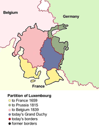
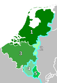
The Seventeen Provinces were the Imperial states of the Habsburg Netherlands in the 16th century. They roughly covered the Low Countries, i.e., what is now the Netherlands, Belgium, Luxembourg, and most of the French departments of Nord and Pas-de-Calais (Artois). Also within this area were semi-independent fiefdoms, mainly ecclesiastical ones, such as Liège, Cambrai and Stavelot-Malmedy.

<span class="mw-page-title-main">William the Silent</span> Dutch statesman and revolt leader (1533–1584)

William the Silent or William the Taciturn, more commonly known in the Netherlands as William of Orange, was the leader of the Dutch revolt against the Spanish Habsburgs that set off the Eighty Years' War (1568–1648) and resulted in the formal independence of the United Provinces in 1648. Born into the House of Nassau, he became Prince of Orange in 1544 and is thereby the founder of the Orange-Nassau branch and the ancestor of the monarchy of the Netherlands. In the Netherlands, he is also known as Father of the Fatherland.

<span class="mw-page-title-main">Maurice, Prince of Orange</span> Dutch Republic stadtholder and Prince of Orange (1567–1625)

Maurice of Orange was stadtholder of all the provinces of the Dutch Republic except for Friesland from 1585 at the earliest until his death in 1625. Before he became Prince of Orange upon the death of his eldest half-brother Philip William in 1618, he was known as Maurice of Nassau.

<span class="mw-page-title-main">Burgrave</span> Official title for the ruler of a castle in medieval Europe

Burgrave, also rendered as burggrave, was since the medieval period in Europe the official title for the ruler of a castle, especially a royal or episcopal castle, and its territory called a Burgraviate or Burgravate.

<span class="mw-page-title-main">Prince of Orange</span> Title originated from the Principality of Orange

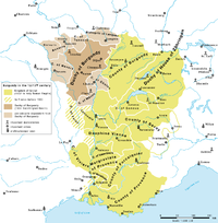
Prince of Orange is a title associated with the sovereign Principality of Orange, in what is now southern France and subsequently held by the stadtholders of, and then the heirs apparent of, the Netherlands.

<span class="mw-page-title-main">Frederick Henry, Prince of Orange</span> Prince of Orange and Stadtholder of Holland

Frederick Henry was the sovereign prince of Orange and stadtholder of Holland, Zeeland, Utrecht, Guelders, Overijssel in the Dutch Republic from 1625 until his death in 1647. In the last seven years of his life, he was also the stadtholder of Groningen (1640-1647).

<span class="mw-page-title-main">Henry III of Nassau-Breda</span> German/Dutch lord (1483–1538)

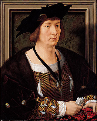
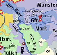
Count Henry III of Nassau-Dillenburg-Dietz, Lord of Breda, Lord of the Lek, of Dietz, etc. was a count of the House of Nassau.

<span class="mw-page-title-main">Breda</span> City and municipality in North Brabant, Netherlands

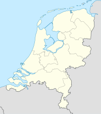
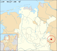
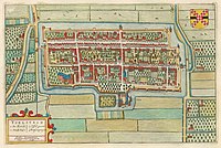
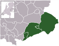
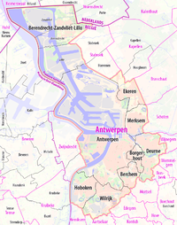
Breda is a city and municipality in the southern part of the Netherlands, located in the province of North Brabant. The name derived from brede Aa and refers to the confluence of the rivers Mark and Aa. Breda has 185,072 inhabitants on 13 September 2022 and is part of the Brabantse Stedenrij; it is the ninth largest city/municipality in the country, and the third largest in North Brabant after Eindhoven and Tilburg. It is equidistant between Rotterdam and Antwerp.

<span class="mw-page-title-main">Philip William, Prince of Orange</span> Prince of Orange from 1584 to 1618

Philip William, Prince of Orange was the eldest son of William the Silent by his first wife Anna van Egmont. He became Prince of Orange in 1584 and Knight of the Golden Fleece in 1599.

<span class="mw-page-title-main">House of Egmond</span>

The House of Egmond or Egmont is named after the Dutch town of Egmond, province of North Holland, and played an important role in the Netherlands during the Middle Ages and the Early modern period. The main lines Egmond-Geldern, Egmond-Gavere and Egmond-Buren-Leerdam had high noble, princely rank.

<span class="mw-page-title-main">House of Nassau</span> Diversified aristocratic dynasty in Europe

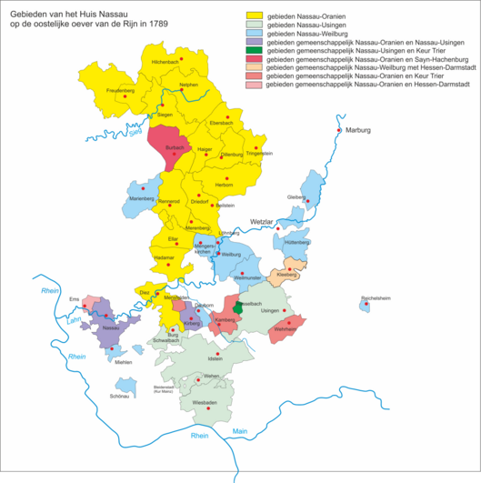
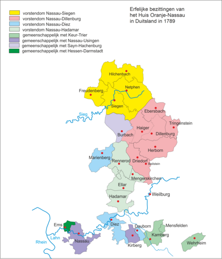
The House of Nassau is a diversified aristocratic dynasty in Europe. It is named after the lordship associated with Nassau Castle, located in present-day Nassau, Rhineland-Palatinate, Germany. With the fall of the Hohenstaufen in the first half of the 13th century royal power within Franconia evaporated and the former stem duchy fragmented into separate independent states. Nassau emerged as one of those independent states as part of the Holy Roman Empire. The lords of Nassau were originally titled "Count of Nassau", subject only to the Emperor, and then elevated to the princely class as "Princely Counts". Early on they divided into two main branches: the elder (Walramian) branch, that gave rise to the German king Adolf, and the younger (Ottonian) branch, that gave rise to the Princes of Orange and the monarchs of the Netherlands.

<span class="mw-page-title-main">Anna van Egmont</span> Princess consort of Orange

Anna van Egmont, mainly known as Anna van Buren, was a Dutch heiress who became the first wife of William the Silent, Prince of Orange.

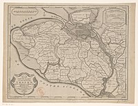
This page is a list of the lords of Chalon-Arlay and the principality of Orange. The lords of Chalons and Arlay were a cadet branch of the ruling house of the county of Burgundy, the Anscarids or House of Ivrea.

<span class="mw-page-title-main">Breda Castle</span> Castle in the Netherlands

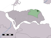
Breda Castle is a castle in the city of Breda, in the Netherlands.

<span class="mw-page-title-main">Monarchy of the Netherlands</span> Constitutional and hereditary monarchy of the Kingdom of the Netherlands

The monarchy of the Netherlands is a constitutional monarchy whose role and position are governed by the Constitution of the Netherlands. Roughly a third of the Constitution explains the succession, mechanisms of accession and abdication to the throne, the roles and duties of the monarch, the formalities of communication between the States General of the Netherlands, and the monarch's role in creating laws.

<span class="mw-page-title-main">John IV, Count of Nassau-Siegen</span> German count (1410–1475)

Count John IV of Nassau-Siegen, German: Johann IV. Graf von Nassau-Siegen, official titles: Graf zu Nassau, Vianden und Diez, Herr zu Breda, was since 1442 Count of Nassau-Siegen, of Vianden and of half Diez, and Lord of Breda and of the Lek. He descended from the Ottonian Line of the House of Nassau.

<span class="mw-page-title-main">Johanna van Polanen</span> Dutch noblewoman

Johanna van Polanen was a Dutch noblewoman. She was the daughter of John III of Polanen, Lord of Breda, and his wife, Odilia of Salm. The House of Polanen was a side branch of the still existing House of Wassenaer.

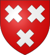
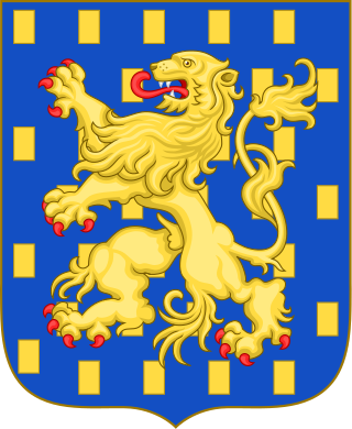
This page shows the coats of arms, heraldic achievements, and heraldic flags of the House of Nassau.

References

  1. (in Dutch)Pennings, J.C.M. & Schreuder, E.A.T.M., ‘Heer en meester van Ameland tot Zwaluwe. Het beheer en bestuur van de heerlijkheden van het Huis Oranje-Nassau door de Nassause Domeinraad (14de eeuw–1811)’ in: Klooster, L.J. van der e.a. (red.), Jaarboek Oranje-Nassau Museum 1994, Barjesteh, Meeuwes & Co Historische Uitgeverij, Rotterdam (1995), p. 45-75, ISBN   90-73714-18-4.
  2. Leopold von Eltester (1881), "Holzappel, Peter Graf zu", Allgemeine Deutsche Biographie (in German), vol. 13, Leipzig: Duncker & Humblot, pp. 21–25
  3. Wilhelm von der Nahmer: Handbuch des Rheinischen Particular-Rechts, Sauerländer, 1832, S. 577 (Google Books)
  4. The Central Limburg Montfort (Montfort, see below) is often confused with Montfoort bij Heeswijk in connection with the king's titles, see [http ://www.kasteelmontfort.eu/index.php?mact=News,cntnt01,detail,0&cntnt01articleid=21&cntnt01returnid=68]. The Limburg Montfort was first given (see below) from Philip IV to William II. Frederick the Great, king of Prussia inherited it, but sold the Limburg Montfort castle in 1769 and the manor of Montfort to the House of Orange, who have since used the title Lord (or Lady) of Montfort. This probably means that the Utrecht Montfort near Heeswijk was never a possession of the Polanens.
  5. Rowen, Herbert H. (1988). The princes of Orange: the stadholders in the Dutch Republic (2 ed.). Baltimore: Cambridge University Press. p. 29. ISBN   978-0-8063-4811-7. LCCN   65021472. :
  6. 1 2 (in Dutch)Pennings, J.C.M. & Schreuder, E.A.T.M., ‘Heer en meester van Ameland tot Zwaluwe. Het beheer en bestuur van de heerlijkheden van het Huis Oranje-Nassau door de Nassause Domeinraad (14de eeuw–1811)’ in: Klooster, L.J. van der e.a. (red.), Jaarboek Oranje-Nassau Museum 1994, Barjesteh, Meeuwes & Co Historische Uitgeverij, Rotterdam (1995), p. 45-75, ISBN   90-73714-18-4.
  7. Noord-Brabant tijdens de Republiek der Verenigde Nederlanden, Willem A. van Ham, blz.31
  8. "Colijnsplaat - (geografische naam)". Etymologiebank (in Dutch). Retrieved 20 April 2022.
  9. Piet van Cruyningen & Ronald Stenvert (2003). Colijnsplaat (in Dutch). Zwolle: Waanders. ISBN   90-400-8830-6 . Retrieved 20 April 2022.
  10. Motley, John Lothrop (1855). The Rise of the Dutch Republic, vol. 2. Harper & Brothers. p. 37.
  11. Young, Andrew (1886). A Short History of the Netherlands (Holland and Belgium). Netherlands: T. F. Unwin. p. 315.
  12. Putnam, Ruth (1895). William the Silent, Prince of Orange: the moderate man of the sixteenth century : the story of his life as told from his own letters, from those of his friends and enemies and from official documents, Volume 1. Putnam. p.  211. viscount of antwerp.
  13. Parker, Geoffrey (2002). The Dutch Revolt. Penguin.
  14. Rowen, Herbert H. (1990). The Princes of Orange: The Stadholders in the Dutch Republic. Cambridge Univ. Press.
  15. Koninklijkhuis (2013). "Frequently asked questions re King William-Alexander". Rijksvoorlichtingsdienst (RVD). Archived from the original (web) on 2013-06-21. Retrieved 2013-05-30. The King's full official titles are King of the Netherlands, Prince of Orange-Nassau, Jonkheer van Amsberg, Count of Katzenelnbogen, Vianden, Diez, Spiegelberg, Buren, Leerdam and Culemborg, Marquis of Veere and Vlissingen, Baron of Breda, Diest, Beilstein, the town of Grave and the lands of Cuyk, IJsselstein, Cranendonk, Eindhoven and Liesveld, Hereditary Lord and Seigneur of Ameland, Lord of Borculo, Bredevoort, Lichtenvoorde, 't Loo, Geertruidenberg, Klundert, Zevenbergen, Hoge and Lage Zwaluwe, Naaldwijk, Polanen, St Maartensdijk, Soest, Baarn and Ter Eem, Willemstad, Steenbergen, Montfort, St Vith, Bütgenbach and Dasburg, Viscount of Antwerp.