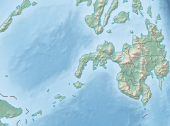
Bukidnon, officially the Province of Bukidnon is a landlocked province in the Philippines located in the Northern Mindanao region. Its capital is the city of Malaybalay. The province borders, clockwise from the north, Misamis Oriental, Agusan del Sur, Davao del Norte, Cotabato, Lanao del Sur, and Lanao del Norte. According to the 2020 census, the province is inhabited by 1,541,308 residents. The province is composed of 2 component cities and 20 municipalities. It is the third largest province in the country in terms of total area of jurisdiction behind Palawan and Isabela respectively.

The Rio Grande de Mindanao, also known as the Mindanao River, is the second-largest river system in the Philippines. Located on the southern island of Mindanao, with a total drainage area of 23,169 km2 (8,946 sq mi), draining the majority of the central and eastern portion of the island, and a total length of approximately 373 km (232 mi). It is an important transportation artery, used mainly in transporting agricultural products and, formerly, timber.

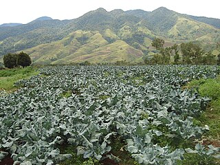
Kitaotao, officially the Municipality of Kitaotao, is a 1st class municipality in the province of Bukidnon, Philippines. According to the 2020 census, it has a population of 53,796 people.
Maramag, officially the Municipality of Maramag, is a 1st class municipality in the province of Bukidnon, Philippines. According to the 2020 census, it has a population of 108,293 people.

The Shilabati River originates near Chak Gopalpur village of Hura block in the Purulia district of the Indian state of West Bengal. It flows in an almost southeasterly direction through the districts of Bankura and Paschim Medinipur. The Shilabati joins the Dwarakeswar near Ghatal and afterwards is known as Rupnarayan. It finally joins the Hooghly River, which empties into the Bay of Bengal.
The Pulangi River, also spelled Pulangui, is one of the major tributaries of the Rio Grande de Mindanao, an extensive river system in Mindanao, Philippines. With a length of 320 kilometres (199 mi), it is the longest river in Bukidnon and the 5th longest river in the Philippines. It traverses through majority of the cities and municipalities of Bukidnon from its source in Barangay Kalabugao, Impasugong, Bukidnon.

Magat Dam is a large rock-fill dam in the island of Luzon in the Philippines. The dam is located along the Magat River, a major tributary of Cagayan River. The construction of the dam started in 1975 and was completed in 1982. It is one of the largest dams in the Philippines. It is a multi-purpose dam which is used primarily for irrigating about 85,000 hectares of agricultural lands, flood control, and power generation through the Magat Hydroelectric Power Plant.
Kalatungan Mountain Range is a mountain range in the central portion of the province of Bukidnon, the Philippines. It is one of the few areas in the province covered with old growth or mossy forests. It covers an area of approximately 213.0134 km2 (82.24493 mi2), with about 113.7175 km2 (43.90657 mi2) identified as part of the critical watershed area declared under Presidential Decree 127, issued on June 29, 1987. The water from two rivers, the Muleta and Manupali Rivers, flood the multimillion dam project of the Philippine National Irrigation Administration (NIA). The rivers drain into the Pulangi River, the site of a National Power Corporation hydroelectric dam.

Kitanglad Mountain Range is a mountain range that dominates the northern central portion of the province of Bukidnon. It occupies portions of eight of the municipalities and cities in the province such as Talakag, Baungon, Libona, Manolo Fortich, Impasugong, Lantapan and Malaybalay. The range is one of the few remaining rainforests in the Philippines, hosting one of the most important diverse species of rare and endemic wildlife such as the Philippine eagle. Five of its peaks have very high elevations: Mount Dulang-dulang, the highest at 2,941 meters; Mount Kitanglad at 2,899 meters; Mount Maagnaw at 2,742 meters; Mount Lumuluyaw at 2,612 meters; and Mount Tuminungan at 2,400 meters.

The Jalaur River, also known as Jalaud River, is the second longest river on Panay island in the Philippines, with a total length of 141 km (88 mi) and the second largest by drainage basin. Only the Panay River in Capiz is longer and with a larger river system. The Jalaur is the 17th largest river system in the Philippines by drainage basin and has an estimated drainage area of 1,503 square kilometres (580 sq mi). Its source is located on Mount Baloy in the Central Panay Mountain Range, and the river traverses east to southeast before emptying into the Guimaras Strait. It drains the eastern portion of Panay and courses through Passi City and the towns of Leganes, Zarraga, Dumangas, Barotac Nuevo, Pototan, Dingle, San Enrique, Duenas, and Calinog, all in Iloilo province.
The Sawaga River is a river in Central Bukidnon, Philippines on the island of Mindanao. A majority of its catchment area is located in Malaybalay City. Its source is from a watershed west of Mt. Tuminungan in Barangay Dalwangan. It flows shortly northward and then eastward into Patpat and Kalasungay, the river then flows southward into the Poblacion District, past Casisang, San Jose, and Laguitas. The Lower Sawaga Valley is located in its lower course from Barangay Linabo through Bangcud until it meets with the Manupali River and ends at Pulangi River in Kahaponan, Valencia City. The Sawaga River has a total length of about 64.5 km and the basin has a total of 42,692 hectares.
The Muleta River is a river draining the southern central portion of the province of Bukidnon in the southern island of Mindanao, Philippines. It is one of the major tributaries of the Pulangi River, which drains into the Rio Grande de Mindanao in Cotabato.
The Pulangi IV Hydroelectric Power Plant, also known as the Pulangi Dam, is located on the Pulangi River near Maramag in Bukidnon province on the island of Mindanao in the Philippines. It uses two reservoirs, produced by damming the Pulangi River, to supply water to a run-of-the-river hydroelectric power plant; the power plant is capable of generating 255 megawatts (342,000 hp) of power. Construction began in 1982; the first two generators became operational in December 1985, with the last generator being commissioned in 1986.

The Pazhassi Dam also called Kulur Barrage is a stone masonry diversion structure in Kannur district, Kerala, India. It is named after king Pazhassi Raja, a patriot who died a heroic death in the war. The dam is constructed across the west flowing Bavali river near Veliyambra. It was commissioned by Prime Minister Morarji Desai in 1979. It mainly functions as an irrigation dam, serving a command area of 11,525 hectares in Iritty taluk of the Kannur District. The water from this dam also meets the drinking water requirement of Kannur district. The dam site and the reservoir are famous for their scenic beauty.

The Molino Dam or Prinza Water Dam is a gravity dam on the Zapote River located on the border between Barangay San Nicolas I, Bacoor, Cavite and Barangay Talon Dos, Las Piñas, Metro Manila, Philippines. It was built by hand in the 19th century to irrigate the surrounding rice field in Las Piñas and Bacoor.
The Kabacan River is a river in the province of Cotabato in the Philippines. It is a tributary of the Pulangi River, discharging at Kayaga, Kabacan, Cotabato.

Telangana is one of the fastest-growing states in India posing average annual growth rate of 13.90% over the last five years. Telangana's nominal gross state domestic product for the year 2020-21 stands at ₹12.05 lakh crore. Service sector is the largest contributor to the Telangana's economy with a share of about 65% in the year 2018-19. Growth in services has largely been fuelled by IT services with the State holding leading position in IT & ITeS in the country in terms of production and exports.
The Malitubog River is one of the major tributaries of the Maradugao River in Mindanao, Philippines. The Malitubog–Maridagao River Irrigation System supports about 5,500 hectares of rice fields within the Autonomous Region in Muslim Mindanao. The Municipality of Alamada's easternmost boundary is ends in the left bank of the river.
The M'lang River is a river located in the municipality of M'lang in Cotabato province in the Philippines. It directs from Liguasan Marsh to Pulangi River basin in flow of Mindanao River.
The Maramag River is located in the province of Bukidnon in the Northern Mindanao region of the Mindanao island group, in the southern Philippines.