
An earthquake – also called a quake, tremor, or temblor – is the shaking of the Earth's surface resulting from a sudden release of energy in the lithosphere that creates seismic waves. Earthquakes can range in intensity, from those so weak they cannot be felt, to those violent enough to propel objects and people into the air, damage critical infrastructure, and wreak destruction across entire cities. The seismic activity of an area is the frequency, type, and size of earthquakes experienced over a particular time. The seismicity at a particular location in the Earth is the average rate of seismic energy release per unit volume.

Seismology is the scientific study of earthquakes and the generation and propagation of elastic waves through the Earth or other planetary bodies. It also includes studies of earthquake environmental effects such as tsunamis as well as diverse seismic sources such as volcanic, tectonic, glacial, fluvial, oceanic microseism, atmospheric, and artificial processes such as explosions and human activities. A related field that uses geology to infer information regarding past earthquakes is paleoseismology. A recording of Earth motion as a function of time, created by a seismograph is called a seismogram. A seismologist is a scientist works in basic or applied seismology.

The epicenter, epicentre, or epicentrum in seismology is the point on the Earth's surface directly above a hypocenter or focus, the point where an earthquake or an underground explosion originates.
In seismology, an aftershock is a smaller earthquake that follows a larger earthquake, in the same area of the main shock, caused as the displaced crust adjusts to the effects of the main shock. Large earthquakes can have hundreds to thousands of instrumentally detectable aftershocks, which steadily decrease in magnitude and frequency according to a consistent pattern. In some earthquakes the main rupture happens in two or more steps, resulting in multiple main shocks. These are known as doublet earthquakes, and in general can be distinguished from aftershocks in having similar magnitudes and nearly identical seismic waveforms.

The 1811–1812 New Madrid earthquakes were a series of intense intraplate earthquakes beginning with an initial earthquake of moment magnitude 7.2–8.2 on December 16, 1811, followed by a moment magnitude 7.4 aftershock on the same day. Two additional earthquakes of similar magnitude followed in January and February 1812. They remain the most powerful earthquakes to hit the contiguous United States east of the Rocky Mountains in recorded history. The earthquakes, as well as the seismic zone of their occurrence, were named for the Mississippi River town of New Madrid, then part of the Louisiana Territory and now within the U.S. state of Missouri.
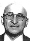
Beno Gutenberg was a German-American seismologist who made several important contributions to the science. He was a colleague and mentor of Charles Francis Richter at the California Institute of Technology and Richter's collaborator in developing the Richter scale for measuring an earthquake's magnitude.
The moment magnitude scale is a measure of an earthquake's magnitude based on its seismic moment. Mw was defined in a 1979 paper by Thomas C. Hanks and Hiroo Kanamori. Similar to the local magnitude/Richter scale (ML ) defined by Charles Francis Richter in 1935, it uses a logarithmic scale; small earthquakes have approximately the same magnitudes on both scales. Despite the difference, news media often use the term "Richter scale" when referring to the moment magnitude scale.

The New Madrid seismic zone (NMSZ), sometimes called the New Madrid fault line, is a major seismic zone and a prolific source of intraplate earthquakes in the Southern and Midwestern United States, stretching to the southwest from New Madrid, Missouri.
Seismic magnitude scales are used to describe the overall strength or "size" of an earthquake. These are distinguished from seismic intensity scales that categorize the intensity or severity of ground shaking (quaking) caused by an earthquake at a given location. Magnitudes are usually determined from measurements of an earthquake's seismic waves as recorded on a seismogram. Magnitude scales vary based on what aspect of the seismic waves are measured and how they are measured. Different magnitude scales are necessary because of differences in earthquakes, the information available, and the purposes for which the magnitudes are used.
Susan Elizabeth Hough is a seismologist at the United States Geological Survey in Pasadena, California, and scientist in charge of the office. She has served as an editor and contributor for many journals and is a contributing editor to Geotimes Magazine. She is the author of five books, including Earthshaking Science (Princeton).

The 1970 Tonghai earthquake occurred at with a moment magnitude of 7.1 and a maximum Mercalli intensity of X (Extreme). The strike-slip rupture originated on the Red River Fault, which had not experienced an earthquake above magnitude 7 since 1700, and affected Tonghai County, Yunnan province, China. At least 10,000 people were killed, making it one of the deadliest in its decade. The tremor caused between US$5 and $25 million in damage, felt over an area of 8,781 km2 (3,390 sq mi). In Hanoi, North Vietnam, almost 483 km (300 mi) from the epicenter, victims left their homes as the rupture rumbled through the city.

The Ramapo Fault zone is a system of faults between the northern Appalachian Mountains and Piedmont areas to the east. Spanning more than 185 miles (298 km) in New York, New Jersey, and Pennsylvania, it is perhaps the best known fault zone in the Mid-Atlantic region, and some small earthquakes have been known to occur in its vicinity. Recently, public knowledge about the fault has increased, especially after the 1970s, when the fault's proximity to the Indian Point nuclear plant in New York was noted.

The 1968 Illinois earthquake was the largest recorded earthquake in the U.S. Midwestern state of Illinois. Striking at 11:02 a.m. on November 9, it measured 5.3 on the Richter scale. Although no fatalities occurred, the event caused considerable structural damage to buildings, including the toppling of chimneys and shaking in Chicago, the region's largest city. The earthquake was one of the most widely felt in U.S. history, largely affecting 23 states over an area of 580,000 sq mi (1,500,000 km2). In studying its cause, scientists discovered the Cottage Grove Fault in the Southern Illinois Basin.
The 1995 Gulf of Aqaba earthquake occurred on November 22 at 06:15 local time and registered 7.3 on the scale. The epicenter was located in the central segment of the Gulf of Aqaba, the narrow body of water that separates Egypt's Sinai Peninsula from the western border of Saudi Arabia. At least 8 people were killed and 30 were injured in the meizoseismal area.
The 1948 Desert Hot Springs earthquake occurred on December 4 at 3:43 p.m. Pacific Standard Time with a moment magnitude of 6.4 and a maximum Mercalli intensity of VII. The shock was felt from the central coast of California in the north, and to Baja California in the south, and came at a time when earthquake research in southern California resumed following the Second World War. It was one of two events in the 20th century that have occurred near a complex region of the southern San Andreas Fault system where it traverses the San Gorgonio Pass and the northern Coachella Valley. Damage was not severe, but some serious injuries occurred, and aftershocks continued until 1957.

Jack H. Healy was an American visionary geophysicist who worked at the US Geological Survey from 1965 to 1995. During his time at the USGS, Healy along with Lou Pakiser, Jerry Eaton, and Barry Raleigh founded the National Center for Earthquake Research at the US Geological Survey.
Seismic intensity scales categorize the intensity or severity of ground shaking (quaking) at a given location, such as resulting from an earthquake. They are distinguished from seismic magnitude scales, which measure the magnitude or overall strength of an earthquake, which may, or perhaps may not, cause perceptible shaking.
The 1930 Bago (Pegu) earthquake, also known as the Swa earthquake struck Myanmar on 5 May. The moment magnitude (Mw ) 7.4 earthquake had a focal depth of 35 km (22 mi) and maximum Rossi–Forel intensity of IX. The earthquake was the result of rupture along a 131 km (81 mi) segment of the Sagaing Fault—a major strike-slip fault that runs through the country. Extensive damage was reported in the southern part of the country, particularly in Bago and Yangon, where buildings collapsed and fires erupted. At least 550, and possibly up to 7,000 people were killed. A moderate tsunami was generated along the Burmese coast which caused minor damage to ships and a port. It was felt for over 570,000 km2 (220,000 sq mi) and as far as Shan State and Thailand. The mainshock was followed by many aftershocks; several were damaging; additional earthquakes occurred in July and December, killing dozens. The December earthquake was similarly sized which also occurred along the Sagaing Fault.
The 1895 Charleston earthquake, also known as the Halloween earthquake, occurred on October 31, at 05:07 CST near Charleston, Missouri. It had an estimated moment magnitude of 5.8–6.6 and evaluated Modified Mercalli intensity of VIII (Severe). The earthquake caused substantial property damage in the states of Missouri, Illinois, Ohio, Alabama, Iowa, Kentucky, Indiana, and Tennessee. Shaking was widespread, being felt across 23 states and even in Canada. At least two people died and seven were injured.
