Marion, South Dakota

Last updated
Marion, South Dakota
Motto: 
"The Right Place To Call Home"
Turner County South Dakota Incorporated and Unincorporated areas Marion Highlighted.svg
Location in Turner County and the state of South Dakota
Coordinates: 43°25′24″N97°15′36″W / 43.42333°N 97.26000°W / 43.42333; -97.26000
Country United States
State South Dakota
County Turner
Incorporated1881 [1]
Area
[2]
  Total0.87 sq mi (2.25 km2)
  Land0.87 sq mi (2.25 km2)
  Water0.00 sq mi (0.00 km2)
Elevation
1,450 ft (442 m)
Population
 (2020) [3]
  Total849
  Density978.11/sq mi (377.75/km2)
Time zone UTC-6 (Central (CST))
  Summer (DST) UTC-5 (CDT)
ZIP code
57043
Area code 605
FIPS code 46-40860 [4]
GNIS feature ID1265666 [5]

Marion is a city in Turner County, South Dakota, United States. The population was 849 at the 2020 census. [6]

Contents

History

Marion was laid out in 1879, and named in honor of a railroad employee's daughter. [7]

Geography

Marion is located at 43°25′24″N97°15′36″W / 43.42333°N 97.26000°W / 43.42333; -97.26000 . [8]

According to the United States Census Bureau, the city has a total area of 0.87 square miles (2.25 km2), all land. [9]

Marion has been assigned the ZIP code 57043 and the FIPS place code 40860.

Demographics

Historical population
CensusPop.Note
1900 338
1910 46236.7%
1920 53515.8%
1930 70431.6%
1940 7658.7%
1950 7943.8%
1960 8436.2%
1970 8440.1%
1980 830−1.7%
1990 8310.1%
2000 8927.3%
2010 784−12.1%
2020 8498.3%
U.S. Decennial Census [10] [3]

2010 census

As of the census [11] of 2010, there were 784 people, 351 households, and 212 families residing in the city. The population density was 901.1 inhabitants per square mile (347.9/km2). There were 384 housing units at an average density of 441.4 per square mile (170.4/km2). The racial makeup of the city was 97.2% White, 0.4% African American, 1.1% Native American, 0.1% Asian, 0.4% from other races, and 0.8% from two or more races. Hispanic or Latino of any race were 2.2% of the population.

There were 351 households, of which 21.7% had children under the age of 18 living with them, 51.9% were married couples living together, 6.3% had a female householder with no husband present, 2.3% had a male householder with no wife present, and 39.6% were non-families. 35.6% of all households were made up of individuals, and 24.8% had someone living alone who was 65 years of age or older. The average household size was 2.09 and the average family size was 2.67.

The median age in the city was 52.3 years. 17.6% of residents were under the age of 18; 5.3% were between the ages of 18 and 24; 16.9% were from 25 to 44; 28.1% were from 45 to 64; and 32% were 65 years of age or older. The gender makeup of the city was 45.7% male and 54.3% female.

2000 census

As of the census [4] of 2000, there were 892 people, 350 households, and 232 families residing in the city. The population density was 1,026.9 inhabitants per square mile (396.5/km2). There were 377 housing units at an average density of 434.0 per square mile (167.6/km2). The racial makeup of the city was 98.99% White, 0.34% Native American, 0.56% from other races, and 0.11% from two or more races. Hispanic or Latino of any race were 1.68% of the population.

There were 350 households, out of which 30.9% had children under the age of 18 living with them, 57.7% were married couples living together, 4.9% had a female householder with no husband present, and 33.7% were non-families. 32.3% of all households were made up of individuals, and 21.4% had someone living alone who was 65 years of age or older. The average household size was 2.39 and the average family size was 3.02.

In the city, the population was spread out, with 25.1% under the age of 18, 5.4% from 18 to 24, 20.5% from 25 to 44, 19.7% from 45 to 64, and 29.3% who were 65 years of age or older. The median age was 44 years. For every 100 females, there were 87.4 males. For every 100 females age 18 and over, there were 81.5 males.

The median income for a household in the city was $36,406, and the median income for a family was $43,375. Males had a median income of $30,417 versus $20,341 for females. The per capita income for the city was $16,125. About 1.3% of families and 3.8% of the population were below the poverty line, including 2.3% of those under age 18 and 8.8% of those age 65 or over.

Notable people

Related Research Articles

<span class="mw-page-title-main">Warren, Indiana</span> Town in Indiana, United States

Warren is a town in Salamonie Township, Huntington County, Indiana. The population of Warren was 1,182 at the time of the 2020 census.

<span class="mw-page-title-main">Syracuse, Indiana</span> Town in Indiana, United States

Syracuse is a town in Turkey Creek Township, Kosciusko County, in the U.S. state of Indiana. The population was 3,079 at the 2020 census. Syracuse is the location of Lake Syracuse and the nearby, larger Lake Wawasee, in addition to several other lakes in the region. The National Weather Service operates a Weather Forecast Office in the town. It serves Northern Indiana.

<span class="mw-page-title-main">Litchville, North Dakota</span> City in North Dakota, United States

Litchville is a city in Barnes County, North Dakota, United States, known for their canoeing and kayaking opportunities. The population was 169 at the 2020 census. Litchville was founded in 1900.

<span class="mw-page-title-main">Lincoln, North Dakota</span> City in North Dakota, United States

Lincoln is a city in Burleigh County, North Dakota, United States. It is a suburb of adjacent Bismarck, and also a core city of the Bismarck-Mandan Metropolitan Statistical Area. The population was 4,257 at the 2020 census, making it the fourteenth largest city in North Dakota. Lincoln was founded in 1977.

<span class="mw-page-title-main">Marion, North Dakota</span> City in North Dakota, United States

Marion is a city in LaMoure County, North Dakota, United States. The population was 125 at the 2020 census.

<span class="mw-page-title-main">Lakota, North Dakota</span> City in North Dakota, United States

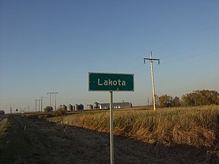
Lakota is a city in Nelson County, North Dakota, United States. It is the county seat of Nelson County Lakota is located 63 miles west of Grand Forks and 27 miles east of Devils Lake. The population was 683 at the 2020 census, making Lakota the 76th-largest city in North Dakota.

<span class="mw-page-title-main">Ardoch, North Dakota</span> City in North Dakota, United States

Ardoch is a city in Walsh County, North Dakota, United States. The population was 31 at the 2020 census. Ardoch, named for the community of Ardoch, Ontario, was founded in 1881.

<span class="mw-page-title-main">Park River, North Dakota</span> City in North Dakota, United States

Park River is a city in Walsh County, North Dakota, United States. The population was 1,424 at the 2020 census. Park River was founded in 1884.

<span class="mw-page-title-main">Kenmare, North Dakota</span> City in North Dakota, United States

Kenmare is a city in Ward County, North Dakota, United States. The population was 961 at the 2020 census. Kenmare is part of the Minot Micropolitan Statistical Area.

<span class="mw-page-title-main">Harvey, North Dakota</span> City in North Dakota, United States

Harvey is a city in Wells County, North Dakota, United States. The population was 1,650 at the 2020 census. Harvey was founded in 1893 as a division point by the Soo Line Railway. Harvey is believed to have been named for a director of the Soo Line Railway, Col. Scott William Harvey of Minneapolis, Minnesota.

<span class="mw-page-title-main">Wagner, South Dakota</span> City in South Dakota, United States

Wagner is a city in Charles Mix County, South Dakota, United States. The population was 1,490 at the 2020 census. The city is served by Wagner Municipal Airport as well as YST Transit buses.

<span class="mw-page-title-main">Clear Lake, South Dakota</span> City in South Dakota, United States

Clear Lake is a city in and the county seat of Deuel County, South Dakota, United States. The population was 1,218 at the 2020 census.

<span class="mw-page-title-main">Miller, South Dakota</span> City in South Dakota, United States

Miller is a city in and county seat of Hand County, South Dakota, United States. The population was 1,349 at the 2020 census.

<span class="mw-page-title-main">Parkston, South Dakota</span> City in South Dakota, United States

Parkston is a city in Hutchinson County, South Dakota, United States. The population was 1,567 at the 2020 census.

<span class="mw-page-title-main">Whitewood, South Dakota</span> City in South Dakota, United States

Whitewood is a city in Lawrence County, South Dakota, United States. The population was 879 at the 2020 census.

<span class="mw-page-title-main">Lennox, South Dakota</span> City in South Dakota, United States

Lennox is a city in Lincoln County, South Dakota, United States, located 20 miles (32 km) southwest of Sioux Falls. The population was 2,423 at the 2020 census.

<span class="mw-page-title-main">Baltic, South Dakota</span> City in South Dakota, United States

Baltic is a city on the Big Sioux River in northern Minnehaha County, South Dakota, United States. The population was 1,246 at the 2020 census.

<span class="mw-page-title-main">Crooks, South Dakota</span> City in South Dakota, United States

Crooks is a city in Minnehaha County, South Dakota, United States and is a suburb of Sioux Falls. The population was 1,362 at the 2020 census. Crooks was named New Hope until 1904. The town's present name honors W. A. Crooks, a local politician.

<span class="mw-page-title-main">Elk Point, South Dakota</span> City in South Dakota, United States

Elk Point is a city in and county seat of Union County, South Dakota, United States. The population was 2,149 as of the 2020 census.

<span class="mw-page-title-main">Weyerhaeuser, Wisconsin</span> Village in Wisconsin, United States

Weyerhaeuser is a village in Rusk County, Wisconsin, United States. The population was 238 at the 2010 census.

References

  1. "SD Towns" (PDF). South Dakota State Historical Society. Archived from the original (PDF) on 2010-02-10. Retrieved 2010-02-14.
  2. "ArcGIS REST Services Directory". United States Census Bureau. Retrieved October 15, 2022.
  3. 1 2 "Census Population API". United States Census Bureau. Retrieved Oct 15, 2022.
  4. 1 2 "U.S. Census website". United States Census Bureau . Retrieved 2008-01-31.
  5. "US Board on Geographic Names". United States Geological Survey. 2007-10-25. Retrieved 2008-01-31.
  6. "U.S. Census Bureau: Marion city, South Dakota". www.census.gov. United States Census Bureau. Retrieved 11 March 2022.
  7. Federal Writers' Project (1940). South Dakota place-names, v.1-3. University of South Dakota. p. 50.
  8. "US Gazetteer files: 2010, 2000, and 1990". United States Census Bureau. 2011-02-12. Retrieved 2011-04-23.
  9. "US Gazetteer files 2010". United States Census Bureau. Archived from the original on 2012-01-25. Retrieved 2012-06-21.
  10. United States Census Bureau. "Census of Population and Housing" . Retrieved June 12, 2016.
  11. "U.S. Census website". United States Census Bureau . Retrieved 2012-06-21.