The street was named with the intention of there being a market place at what is now the railway station site, however markets were never established.[1]
John K. Ewers, a Western Australian poet and writer, wrote a poem about the street in 1932 that included the following lines, no doubt reflecting on the people leaving or arriving at the railway station and the port:
The folk you meet in Market-street are humble folk and grand: [...] The sights you see in Market-street are stranger than a dream:[2]
↑ Ewers, John K. (1971). The Western Gateway: A History of Fremantle (2nded.). Nedlands, Western Australia: University of Western Australia Press for the Fremantle City Council. p.225. ISBN085564 050 2.
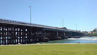
The Causeway is an arterial traffic crossing in Perth, Western Australia, linking the inner-city suburbs of East Perth and Victoria Park. It is carried over the Swan River at the eastern end of Perth Water by two bridges on either side of Heirisson Island. The current Causeway is the third structure to have been built across the river at this point.
Leach Highway is a 23-kilometre (14 mi) east-west arterial highway in the southern suburbs of Perth, Western Australia, primarily linking Kewdale and Perth Airport with the city of Fremantle.
The Horseshoe Bridge in Perth, Western Australia is a traffic bridge that connects the Perth CBD to Northbridge, carrying William Street. It was constructed in 1904 to pass over the Fremantle railway line, with the horseshoe shape designed to fit the approach ramps into a constricted site.
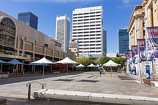
Forrest Place is a pedestrianised square located within the CBD of Perth, Western Australia. The street was created in 1923, and has a history of being a focal point for significant political meetings and demonstrations.
Queen Victoria Street is the main road entering the city centre of Fremantle, Western Australia from the direction of Perth. The road was originally named Cantonment Road, but was subsequently renamed Victoria Road, and a few years later Queen Victoria Street, after Queen Victoria of the United Kingdom, to avoid confusion with similarly named roads in the area.
Hampton Road is the main road entering the City of Fremantle from the south. It is named after John Stephen Hampton, the Governor of Western Australia from 1862 to 1868. It continues into Ord Street at the north east corner of Fremantle Prison at Knutsford Street.
Mounts Bay Road is a major road in Perth, Western Australia, extending southwest from the central business district along the north bank of the Swan River, at the base of Kings Park.
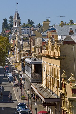
High Street is the main street running through the City of Fremantle, Western Australia. The street passes by historic landmarks, including the Round House, the Fremantle Town Hall, and the Fremantle War Memorial, through the Fremantle West End Heritage area and through two town squares. Trams operated along High Street for 47 years, between 1905 and 1952. Running east–west, High Street continues as Leach Highway, a major arterial road, at Stirling Highway, linking Fremantle with Perth Airport although the stretch of road between Stirling Highway and Carrington Street is known locally—and signed—as High Street.
Marine Terrace is a road on the southern side of the built up area of Fremantle, Western Australia. It is named for its location alongside the water front.
Ellen Street is a parallel road to High Street in Fremantle, Western Australia. It was named after Ellen Stirling, wife of Governor Stirling.
Queen Street is a street in Fremantle, Western Australia that crosses High Street at Kings Square, and is located away from and west of Queens Square. It is a separate street from Queen Victoria Street, which is located 500 metres (0.3 mi) further north. The street is named after Queen Adelaide, consort of William IV.
South Terrace, Fremantle is a road in Fremantle, Western Australia that is renowned as the "Cappucino Strip" of Fremantle, due to the high number of coffee shops and restaurants.
Walyalup Koort, formerly known as Kings Square (or King's Square), is a town square in Fremantle, Western Australia. It is bounded by Queen, Newman, William, and Adelaide Streets. Though the square was originally a public reserve, it has been the site of Saint John's Church of England since 1843, and the Fremantle Town Hall since 1887. High Street was extended through and beyond the square in the 1880s, but the portion through the square was closed off in the 1960s. Today Kings Square functions as a civic and cultural centre of Fremantle, with modern events taking place adjacent to the historic buildings.
Adelaide Street, Fremantle is a street that is a boundary for Kings Square, Fremantle in Western Australia. It goes north from Kings Square and meets Queen Victoria Street in a skewed junction that meets outside St Patrick's Basilica.
Parry Street is a street in Fremantle, Western Australia.
Henry Street is a 400-metre-long (1,300 ft) street in Fremantle, Western Australia. It was named after John Henry, second lieutenant of HMS Challenger. It was developed very early in the history of the Swan River Colony with licensed premises being located as early as 1833.
South Street is an east-west arterial highway in the southern suburbs of Perth, Western Australia. It runs from Canning Vale to Fremantle, and is part of State Route 13.
Milligan Street is a street in Perth, Western Australia that runs from St Georges Terrace to north of Wellington Street. The northern section provides access to the Perth Arena carpark and Telethon Avenue; there are also dedicated Transperth bus roads connecting to the northern end, south of the Fremantle railway line.
This page is based on this Wikipedia article Text is available under the CC BY-SA 4.0 license; additional terms may apply. Images, videos and audio are available under their respective licenses.