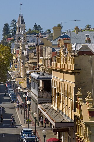
South Terrace, Fremantle is a road in Fremantle, Western Australia that is renowned as the "Cappucino Strip" of Fremantle,[1] due to the high number of coffee shops and restaurants.
View along South Terrace, from Market Street to Essex Street
A number of historic hotels are on South Terrace, including the Sail and Anchor (formerly the Freemasons Hotel[3][4]), the Newport, Norfolk, Davilak and South Beach hotels.
Toodyay, known as Newcastle between 1860 and 1910, is a town on the Avon River in the Wheatbelt region of Western Australia, 85 kilometres (53 mi) north-east of Perth. The first European settlement occurred in the area in 1836. After flooding in the 1850s, the townsite was moved to its current location in the 1860s. It is connected by railway and road to Perth. During the 1860s, it was home to bushranger Moondyne Joe.
Canning Highway is an arterial road in Perth, Western Australia, linking the inner Perth suburb of Victoria Park in the north-east, to the port city of Fremantle in the south-west.
St Georges Terrace is the main street in the city of Perth, Western Australia. It runs parallel to the Swan River and forms the major arterial thoroughfare through the central business district.
Adelaide Terrace is a major arterial road through the central business district of Perth, Western Australia. It runs parallel to the Swan River, linking St Georges Terrace with The Causeway.
Queen Victoria Street is the main road entering the city centre of Fremantle, Western Australia, from the direction of Perth. The road was originally named Cantonment Road, but was subsequently renamed Victoria Road, and a few years later Queen Victoria Street, after Queen Victoria of the United Kingdom, to avoid confusion with similarly named roads in the area.
Mounts Bay Road is a major road in Perth, Western Australia, extending southwest from the central business district along the north bank of the Swan River, at the base of Kings Park.
Riverside Drive in Perth, Western Australia, is a road on the northern side of Perth Water. It was built on reclaimed land in the 1930s, and links The Causeway to the Narrows Bridge.
The Esplanade Hotel is a hotel located opposite Esplanade Park, on the corner of Essex Street and Marine Terrace, Fremantle, Western Australia. The building stands on the site of the first building used for housing convicts transported from Great Britain in 1850.
High Street is the main street running through the City of Fremantle, Western Australia. The street passes by historic landmarks, including the Round House, the Fremantle Town Hall, and the Fremantle War Memorial, through the Fremantle West End Heritage area and through two town squares. Trams operated along High Street for 47 years, between 1905 and 1952. Running east–west, High Street continues as Leach Highway, a major arterial road, at Stirling Highway, linking Fremantle with Perth Airport although the stretch of road between Stirling Highway and Carrington Street is known locally—and signed—as High Street.
Esplanade Park is a public reserve in Fremantle, Western Australia. Situated on Marine Terrace and opposite the Esplanade Hotel, the reserve features about 100 mature Norfolk Island pines and the Explorers' Monument.
Marine Terrace is a road on the southern side of the built up area of Fremantle, Western Australia. It is named for its location alongside the water front.
Walyalup Koort, formerly known as Kings Square (or King's Square), is a town square in Fremantle, Western Australia. It is bounded by Queen, Newman, William, and Adelaide Streets. Though the square was originally a public reserve, it has been the site of Saint John's Church of England since 1843, and the Fremantle Town Hall since 1887. High Street was extended through and beyond the square in the 1880s, but the portion through the square was closed off in the 1960s. Today Kings Square functions as a civic and cultural centre of Fremantle, with modern events taking place adjacent to the historic buildings.
Market Street, Fremantle is the location of the Fremantle Post Office in Fremantle, Western Australia.
Mouat Street is a 300-metre-long (980 ft) street in Fremantle, Western Australia. Historically, the name was often spelled as Mouatt Street.
The Sail and Anchor Hotel is located on the corner of South Terrace and Henderson Street in Fremantle, Western Australia, opposite the Fremantle Markets.
Henry Street is a 400-metre-long (1,300 ft) street in Fremantle, Western Australia. It was named after John Henry, second lieutenant of HMS Challenger. It was developed very early in the history of the Swan River Colony with licensed premises being located as early as 1833.
Metropolis Fremantle, formerly known as King's Theatre, is a performance venue and nightclub located at 58 South Terrace, Fremantle, adjacent to the Sail and Anchor Hotel.
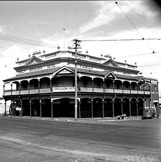
The Norfolk Hotel is located on the corner of South Terrace and Norfolk Street in Fremantle, Western Australia. The stone built hotel was originally constructed in 1887 before the 1893 Kalgoorlie gold rush for George Alfred Davies, a vintner, local councillor and Mayor of Fremantle. For most of its life it was known as the Oddfellows Hotel; it was renamed when it was substantially renovated in 1985.
Stirling Terrace is the main street of Toodyay, Western Australia, originally called New Road until 1905.
Collie Street is in Fremantle, Western Australia.
This page is based on this Wikipedia article Text is available under the CC BY-SA 4.0 license; additional terms may apply. Images, videos and audio are available under their respective licenses.