
Marsh Green is a small hamlet in Eden Vale, part of the parish of Edenbridge, England. The hamlet was founded in 1554 under its current name.
Marsh Green claims the last bare-knuckle boxing fight in England, in 1886.
Marsh Green is a small hamlet in Eden Vale, part of the parish of Edenbridge, England. The hamlet was founded in 1554 under its current name.
Marsh Green claims the last bare-knuckle boxing fight in England, in 1886.
51°10′43″N0°03′24″E / 51.1785°N 0.0566°E
| | This Kent location article is a stub. You can help Wikipedia by expanding it. |

Green Hailey is a hamlet in the parish of Great and Little Hampden, in Buckinghamshire, England. It is located to the west of the main village of Great Hampden. The hamlet, as of the early 21st century, includes essentially just two cottages and a farm. It was farmed in the late 19th century by Richard Paxton, together with his wife Mary, who together had seven children.
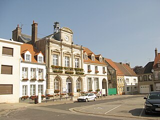
Guînes is a commune in the northern French department of Pas-de-Calais. Historically, it was spelt Guisnes.

Northall is a hamlet in the parish of Edlesborough, in Buckinghamshire, England.
Ash-cum-Ridley is a civil parish in the Sevenoaks district of Kent, England. According to the 2001 census the parish had a population of 7,070, reducing to 6,641 at the 2011 Census.

Rainham Marshes is an RSPB nature reserve in the east of London, adjacent to the Thames Estuary in Purfleet, Thurrock and the London Borough of Havering.

Fawkham is a village and civil parish in the Sevenoaks District of Kent, England. Fawkham is defined as a hamlet by Sevenoaks District Council, with a population of 429. Fawkham is a low density, linear settlement along the bottom of a dry chalk valley some 3 mi (5 km) in length, with secondary lanes intersecting. There is no discernible village centre, although clusters of buildings occur near the Church/junction with Castle Hill, and around the village green and public house at the junction with Fawkham Green Road. There are around 220 houses.

Lye Green is a hamlet in the civil parish of Chesham in Buckinghamshire, England. It is located north east of Chesham. Lycrome Road runs through the centre of the hamlet, from the A416 in the east to the B4505 in the west.
Orchard Leigh is a hamlet in the parish of Latimer in Buckinghamshire, England, located along the B4505 about 2 miles east of Chesham. It is in the civil parish of Ashley Green.

Skittle Green is a hamlet in the civil parish of Bledlow-cum-Saunderton in the county of Buckinghamshire, England.

Spurlands End is a hamlet in the parish of Little Missenden, in Buckinghamshire, England.

Middle Green is a hamlet in the civil parish of Wexham in Buckinghamshire, England. It is located within the Metropolitan Green Belt bordering the north-east edge of Slough and close to the Slough Arm of the Grand Union Canal. Just to the south of the hamlet is the Middlegreen Trading Estate.

Highwood is a village and civil parish in the Chelmsford district of Essex, England. The village is approximately a mile south from the A414 road and four miles west from the centre of the county town of Chelmsford. Loves Green is part of the village at its center, with Cooksmill Green and Radley Green to the North. The hamlet of Edney Common is at the east of the parish. In 2011 the parish had a population of 654.
Ravenmeols is a Metropolitan Borough of Sefton ward in the Sefton Central Parliamentary constituency that covers the village of Ince Blundell and the nearby hamlets of Lady Green and Carr Houses, the village of Little Altcar, and the eastern half of the town of Formby including the eastern half of the area known as Freshfield. The population of this ward taken at the 2011 census was 12,065.
Holder's Green is a hamlet near the village of Lindsell, in the Uttlesford district of Essex, England.
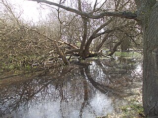
Ickenham Marsh is an area of grassland and marsh in the London Borough of Hillingdon. It is managed as a nature reserve by London Wildlife Trust.
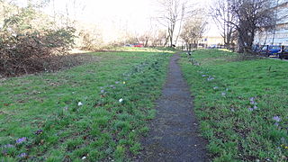
Ackroyd Drive Greenlink is a 0.87 hectare Local Nature Reserve in Bow Common in the London Borough of Tower Hamlets. It forms a green corridor between Tower Hamlets Cemetery Park and Mile End Park.

Moorend Common is a 28-hectare (69-acre) Site of Special Scientific Interest in the hamlet Moor End, west of High Wycombe in Buckinghamshire. It is in the Chilterns Areas of Outstanding Natural Beauty, and it is owned and managed by Lane End Parish Council.

West Thurrock Lagoon and Marshes is a 66.1-hectare (163-acre) biological Site of Special Scientific Interest in West Thurrock in Essex.

The Lion is a former public house on the corner of Barnet Road and Southgate Road in Potters Bar, Hertfordshire, England, and a grade II listed building with Historic England. It became Potty Pancakes some time after 2008.

The Horns is a public house in Datchworth, Hertfordshire, England. It is situated on Bramfield Road in Bull's Green, a hamlet in the parish of Datchworth.
