
Transportation in Boston includes roadway, subway, regional rail, air, and sea options for passenger and freight transit in Boston, Massachusetts. The Massachusetts Port Authority (Massport) operates the Port of Boston, which includes a container shipping facility in South Boston, and Logan International Airport, in East Boston. The Massachusetts Bay Transportation Authority (MBTA) operates bus, subway, short-distance rail, and water ferry passenger services throughout the city and region. Amtrak operates passenger rail service to and from major Northeastern cities, and a major bus terminal at South Station is served by varied intercity bus companies. The city is bisected by major highways I-90 and I-93, the intersection of which has undergone a major renovation, nicknamed the Big Dig.

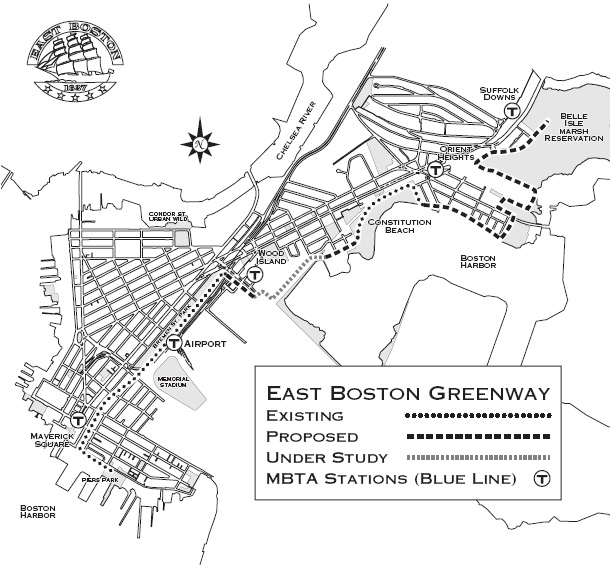
East Boston, nicknamed Eastie, is a neighborhood of Boston, Massachusetts, United States that was annexed by the city of Boston in 1637. Neighboring communities include Winthrop, Revere, and Chelsea. It is separated from the Boston neighborhood of Charlestown and downtown Boston by Boston Harbor. The footprint of the East Boston neighborhood as it is known today was created in the 1940s by connecting five of the inner harbor islands using land fill. Logan International Airport is located in East Boston, connecting Boston to domestic and international locations.

Airport station is a rapid transit station in Boston, Massachusetts. It serves the MBTA Blue Line and the SL3 branch of the Silver Line. It is located in East Boston under the interchange between Interstate 90 and Massachusetts Route 1A. The station provides one of two mass transit connections to the nearby Logan International Airport, as well as serving local residents in East Boston. Shuttle buses connect the station with the airport terminals and other facilities.
The Grand Junction Railroad is an 8.55-mile (13.76 km) long railroad in the Boston, Massachusetts, area, connecting the railroads heading west and north from Boston. The line is notable for its railroad bridge over the Charles River that passes under the Boston University Bridge between Boston and Cambridge, Massachusetts.

The Mass Central Rail Trail (MCRT) is a partially completed rail trail between Northampton, Massachusetts and Boston along the former right-of-way (ROW) of the Massachusetts Central Railroad. It currently has 59 miles (95 km) open, and 94.5 miles (152.1 km) are open or protected for trail development. When complete, it will be 104 miles (167 km) long through Central Massachusetts and Greater Boston, forming the longest rail trail in New England. Many sections of the trail, including the Norwottuck Branch of the Mass Central Rail Trail and the Somerville Community Path, have been developed as separate projects but serve as part of the complete Mass Central Rail Trail. The Norwottuck Network, a 501(c)(3) nonprofit that supports the build and operation of the MCRT, maintains an interactive map of the MCRT and other Massachusetts trails.

Alewife Brook Reservation is a Massachusetts state park and urban wild located in Cambridge, Arlington, and Somerville. The park is managed by the state Department of Conservation and Recreation and was established in 1900. It is named for Alewife Brook, which was also historically known as Menotomy River, a tributary of the Mystic River.

The Bloomingdale Trail is a 2.7-mile (4.3 km) elevated rail trail linear park running east–west on the northwest side of Chicago. It is the longest greenway project of a former elevated rail line in the Western Hemisphere, and the second longest in the world, after the Promenade plantee linear park in Paris. In 2015, the City of Chicago converted the former Bloomingdale railway line to an elevated greenway, which forms the backbone of the 606 trail network. The Bloomingdale Trail elevated park is in the Logan Square, Humboldt Park, and West Town community areas.

A greenway is usually a shared-use path along a strip of undeveloped land, in an urban or rural area, set aside for recreational use or environmental protection. Greenways are frequently created out of disused railways, canal towpaths, utility company rights of way, or derelict industrial land. Greenways can also be linear parks, and can serve as wildlife corridors. The path's surface may be paved and often serves multiple users: walkers, runners, bicyclists, skaters and hikers. A characteristic of greenways, as defined by the European Greenways Association, is "ease of passage": that is that they have "either low or zero gradient", so that they can be used by all "types of users, including mobility impaired people".

Wood Island station is an MBTA Blue Line rapid transit station located off Bennington Street in the Day Square section of East Boston, Boston, Massachusetts. The station is adjacent to and named for the former Wood Island Park, a once heavily used recreational area for East Boston residents. Most of the park was destroyed in the mid 1960s to expand Logan International Airport. It was built in 1952, replacing a pair of Boston, Revere Beach and Lynn Railroad stations that served the area.

The John H. Chafee Blackstone River Valley National Heritage Corridor is a National Heritage Corridor dedicated to the history of the early American Industrial Revolution, including mill towns stretching across 25 cities and towns near the river's course in Worcester County, Massachusetts, and Providence County, Rhode Island. It makes up a historical area in the Blackstone Valley and is named for the late US Senator from Rhode Island John Chafee. In 2014, the Blackstone River Valley National Historical Park was created out of a smaller portion of the National Heritage Corridor. The two units now exist as cooperative entities. The organization is headquartered at the building in Whitinsville, MA, which is located at 670 Linwood Ave, Whitinsville, MA 01588.

Transportation in Greater St. Louis, Missouri includes road, rail, ship, and air transportation modes connecting the bi-state St. Louis metropolitan area with surrounding communities throughout the Midwest, national transportation networks, and international locations. The Greater St. Louis region also supports a multi-modal transportation network that includes bus, paratransit, and light rail service in addition to shared-use paths, bike lanes and greenways.

The Wallkill Valley Rail Trail is a 23.7-mile (38.1 km) rail trail and linear park that runs along the former Wallkill Valley Railroad rail corridor in Ulster County, New York, United States. It stretches from Gardiner through New Paltz, Rosendale and Ulster to the Kingston city line, just south of a demolished, concrete Conrail railroad bridge that was located on a team-track siding several blocks south of the also-demolished Kingston New York Central Railroad passenger station. The trail is separated from the Walden–Wallkill Rail Trail by two state prisons in Shawangunk, though there have been plans to bypass these facilities and to connect the Wallkill Valley Rail Trail with other regional rail-trails. The northern section of the trail forms part of the Empire State Trail.

The East Bay Bike Path is a 14.5-mile (23.3 km) paved rail trail in Rhode Island. The path originates in Providence and India Point Park, crosses the Seekonk River via the George Redman Linear Park and the Washington Bridge, and continues southeast to Bristol along the shoreline of Narragansett Bay. The path passes through the city of East Providence, the hamlet of Riverside, and the towns of Barrington and Warren. It is part of the East Coast Greenway, a 3,000-mile system of trails connecting the Canada–US border in Maine to Key West, as well as provides access to Haines State Park, Brickyard Pond (Barrington), and Colt State Park.

A linear park is a type of park that is significantly longer than it is wide. These linear parks are strips of public land running along canals, rivers, streams, defensive walls, electrical lines, or highways and shorelines. Examples of linear parks include everything from wildlife corridors to riverways to trails, capturing the broadest sense of the word. Other examples include rail trails, which are disused railroad beds converted for recreational use by removing existing structures. Commonly, these linear parks result from the public and private sectors acting on the dense urban need for open green space. Linear parks stretch through urban areas, coming through as a solution for the lack of space and need for urban greenery. They also effectively connect different neighborhoods in dense urban areas as a result, and create places that are ideal for activities such as jogging or walking. Linear parks may also be categorized as greenways. In Australia, a linear park along the coast is known as a foreshoreway. When being designed, linear parks appear unique as they are planned around the public's opinion of how the space will affect them.

The Farmington Canal Heritage Trail is an 82-mile (132 km) multi-use rail trail located in Connecticut and Massachusetts.

Boston Harborwalk is a public walkway that follows the edge of piers, wharves, beaches, and shoreline around Boston Harbor. When fully completed it will extend a distance of 47 miles (76 km) from East Boston to the Neponset River.

This is a list of trails and greenways in Detroit.
The Middlesex Greenway is a 3.5 miles (5.6 km) rail trail in New Jersey Metuchen, Edison and Woodbridge. It is part of the Middlesex County Park System. It makes up a portion of the East Coast Greenway.
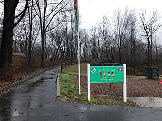
Bremen Street Park is an 18-acre urban park, located in East Boston, Boston, Massachusetts. The park runs parallel to both Bremen Street and the Mass Pike/Route 1A and acts as a green space buffer between Logan International Airport and the residential neighborhoods of East Boston. The park is owned, operated and patrolled by the Massachusetts Port Authority (MassPort). It is also part of the East Boston Greenway, a linear park and shared use path.


