
Mary Kathleen was a mining settlement in north-western Queensland, Australia. It is located in the Selwyn Range between Mount Isa and Cloncurry.
Mary Kathleen was a mining settlement in north-western Queensland, Australia. It is located in the Selwyn Range between Mount Isa and Cloncurry.
Mary Kathleen was first settled during the 1860s. Uranium was first discovered at Mary Kathleen by Clem Walton and Norm McConachy in 1954: the deposit and the township was named after the late wife of McConachy. [1] Prospecting and exploitation rights were subsequently on-sold, and in 1955 Rio Tinto Mining formed Mary Kathleen Uranium Ltd to develop a mine and service town. An architect-designed town grew during 1956-58, with reticulated water from a dam, Lake Corella. [2]
St Peter's Catholic Church was built in 1958. After the town closed, the church building was relocated to be a shelter shed at Saint Joseph’s Catholic School in Mount Isa. [3]

In 1954, a significant uranium deposit was discovered at the site (20.7470°S, 140.0123°E). [4] A sales contract with the United Kingdom Atomic Energy Authority was signed in 1956. Mining commenced at the end of 1956 and the treatment plant was commissioned in June 1958. The project was developed by Mary Kathleen Uranium Limited (MKU) at a cost of A $24 million. [5] MKU was formed to develop the uranium deposits and work was soon commenced constructing the township, mine, and dam on the nearby Corella River. The ore was mined by the open-cut method and processed on site. [2] In the first phase of operation from 1958 to 1963 Mary Kathleen treated 2.9 million tonnes of ore at an average grade of 0.13% to yield 4082 t (4500 short tons or 9 million pounds weight of U3O8) of uranium concentrate (then actually yellowcake - ammonium diuranate) containing 3460 tonnes of uranium. [5] By 1963 the major supply contract had been satisfied ahead of schedule, and large reserves of ore lay at grass. Consequently, the works were closed down. [2]
The mine then lay idle until 1974, when it was reopened. New supply contracts with Japanese, German and American power utilities prompted this re-opening, with Mary Kathleen's second life extended to 1982 when reserves were finally exhausted. [2] The company made a share issue to raise capital, and the Commonwealth Government, through the Australian Atomic Energy Commission underwrote this, thereby obtaining a 42% holding in the company. Conzinc Riotinto of Australia Limited, a successor of Rio Tinto Mining, held 51%, and the public 7%. [5] The second phase of production began in 1976 and the mine was finally closed down in 1982 after a further production of 4,802 tonnes of uranium oxide. A total of 31 million tonnes of ore were extracted from the mine until it was exhausted. [6] Processing occurred on-site.
Mary Kathleen's uranium deposits originated from contact metasomatic processes. [7] This type of occurrence is uncommon, with Mary Kathleen being the only commercial example. The uraninite here was conglomerated with garnet. [7]
The town, 6 km away from the mine, was built around a shallow valley with a post office, cinema, sports ovals, a school, banks and a community store. [2] The state school was opened in July 1956; temporary hospital facilities and a community store in March 1957; and May 1957 saw the first water pumped from Lake Corella Dam. [1] By 1961, approximately 1000 people lived at the new township.
The Australian Broadcasting Corporation transmitted to Mary Kathleen via its relay station, ABMKQ, which was shut down when the town was abandoned in 1982.
Mary Kathleen was very much a planned, "model" township, blending with its surrounding environment. Two years later, however, with contracts fulfilled, the mine and township temporarily closed.
When the mine re-opened in mid-1974, the population at Mary Kathleen subsequently grew from 80 in August 1974 to 700 in August 1975 and peaked at approximately 1200 in 1981. During its "second life", existing private and community structures and services were revamped and augmented by new additions provided principally by Mary Kathleen Uranium Limited and the Cloncurry Shire Council. [1]
The former town of Mary Kathleen has a unique feature in Australian sport history. The former Australian Rules club (Mary Kathleen) won three consecutive premierships from 1977 to 1979 in the Mount Isa Australian Football League, and is one of the few clubs or towns for that matter to win Senior titles, and no longer be in existence as a club or any population in its locality.

With all contracts filled by late 1982, the township, mine and mill were dismantled and the tailings rehabilitated by the end of 1984. [4] Mary Kathleen became the site of Australia's first major rehabilitation project of a uranium mine, which was completed at the end of 1985 at a cost of some A$19 million. In 1986, this work won an award from the Institution of Engineers Australia for environmental excellence. [5] The site became well known for fossicking and gem-stone collecting, and numerous relics are held in the Cloncurry/Mary Kathleen Memorial Park and Museum in Cloncurry. [2] The site, now only roads and concrete pads, can be accessed, as an overnight camp, from the Barkly Highway at -20.780837,139.9734. [8] The land has since been rehabilitated and is now suitable for grazing. [9]
Since rehabilitation, it has been found that the tailings repository at the Mary Kathleen site has been subject to seepage of radioactive waters from both the toe of the dam and the surface at rates much higher than initially predicted. [10]

Jabiluka is a pair of uranium deposits and mine development in the Northern Territory of Australia that was to have been built on land belonging to the Mirarr clan of Aboriginal people. The mine site is surrounded by, but not part of, the World Heritage–listed Kakadu National Park.

Rum Jungle is a locality in the Northern Territory of Australia located about 105 kilometres south of Darwin on the East Branch of the Finniss River. It is the site of a uranium deposit, found in 1949, which has been mined.

Mining in Australia has long been a significant primary sector industry and contributor to the Australian economy by providing export income, royalty payments and employment. Historically, mining booms have also encouraged population growth via immigration to Australia, particularly the gold rushes of the 1850s. Many different ores, gems and minerals have been mined in the past and a wide variety are still mined throughout the country.
Rio Tinto Coal Australia (RTCA) was an Australian coal mining organisation, that was part of the worldwide Rio Tinto Group. In 2018, Rio Tinto completed the sale of its remaining assets
Paladin Energy Ltd is a Western Australian based uranium production company.
Mount Isa Mines Limited ("MIM") operates the Mount Isa copper, lead, zinc and silver mines near Mount Isa, Queensland, Australia as part of the Glencore group of companies. For a brief period in 1980, MIM was Australia's largest company. It has pioneered several significant mining industry innovations, including the Isa Process copper refining technology, the Isasmelt smelting technology, and the IsaMill fine grinding technology, and it also commercialized the Jameson Cell column flotation technology.
East Leichhardt Dam is a dam built in 1961 on the East Leichhardt River which impounds Lake Mary Kathleen, Queensland. The dam is located 25 km east of Mount Isa, Queensland, and 9 km south of the Barkly Highway.
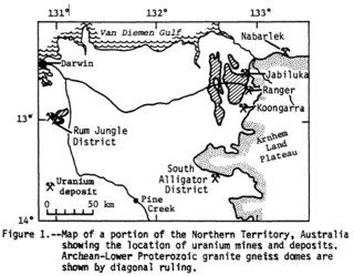
The Nabarlek Mine is a uranium mine in the Northern Territory of Australia which was productively worked only in 1979. The deposit sits within the Alligator Rivers Uranium Field approximately 62 kilometres (39 mi) northeast of Jabiru. It was discovered by Queensland Mines Limited in 1970 by following up an intense airborne radiometric anomaly.
Radioactive ores were first extracted in South Australia at Radium Hill in 1906 and Mount Painter in 1911. 2,000 tons of ore were treated to recover radium for medical use. Several hundred kilograms of uranium were also produced for use in ceramic glazes.
The Honeymoon Mine was Australia's second operating in-situ recovery uranium mine, beginning production in 2011. It is located in South Australia and is 80 kilometres (50 mi) northwest of Broken Hill, New South Wales.

Radium Hill is a former minesite in South Australia which operated from 1906 until 1961. It was Australia's first uranium mine, years before the country's next major mines at Rum Jungle in the Northern Territory (opened in 1950), and the Mary Kathleen mine in Queensland (1958). The associated settlement which once housed up to 1,100 people is now a ghost town, largely abandoned and demolished. The former townsite and cemetery were provisionally listed on the South Australian Heritage Register on 24 August 2016. During its main period of production between 1954 and 1961 the mine produced nearly 1 million tonnes of davidite-bearing ore to produce about 860 tons of U3O8.
The Kintyre uranium project is located 60 km south of the Telfer gold mine and 260 km northeast of Newman at the western edge of the Great Sandy Desert in the East Pilbara region of Western Australia.
Turquoise Hill Resources was a Canadian mineral exploration and development company headquartered in Montreal, Quebec, and a majority-owned subsidiary of Rio Tinto Group. The company was called Ivanhoe Mines until August 2, 2012 when a financing agreement was completed with Rio Tinto. Rio Tinto acquired full ownership of Turquoise Hill in December 2022.

Iron ore mining in Western Australia, in the 2018–19 financial year, accounted for 54 percent of the total value of the state's resource production, with a value of A$78.2 billion. The overall value of the minerals and petroleum industry in Western Australia was A$145 billion in 2018–19, a 26 percent increase on the previous financial year.
The Great Northern Railway is a 1067 mm gauge railway line in Queensland, Australia. The line stretches nearly 1,000 kilometres linking the port city of Townsville, Australia to the mining town of Mount Isa in north-west Queensland. Along with a passenger service called the Inlander, it is a major freight route connecting the Mount Isa Mines to the Port of Townsville. In 2010, the line moved 5.8 million tonnes of cargo, and this is expected to increase significantly in coming years.
The Ernest Henry mine is a large copper mine located in eastern Australia, 38 kilometres north of Cloncurry in the state of Queensland. Ernest Henry represents one of the largest copper reserves in Australia and in the world having estimated reserves of 167 million tonnes of ore grading 1.1% copper and 2.67 million oz of gold. Silver is also produced at the mine. The mine produced 64,000 tonnes of copper and 92,000 ounces of gold in the financial year to 2021.

Kuridala Township site is a heritage-listed mining camp in the locality of Kuridala, Shire of Cloncurry, Queensland, Australia. It was built from 1880s to 1920s. It is also known as Hampden Township, Hampden Smelter, Kuridala Smelter, and Friezeland Township. It was added to the Queensland Heritage Register on 12 June 2009.
Mount Elliott Mining Complex is a heritage-listed copper mine and smelter at Selwyn, Shire of Cloncurry, Queensland, Australia. It was designed by William Henry Corbould and built in 1908. It is also known as Mount Elliott Smelter and Selwyn. It was added to the Queensland Heritage Register on 16 September 2011.

Gunpowder is an outback town and locality in the City of Mount Isa, Queensland, Australia. In the 2016 census, Gunpowder had a population of 43 people.