Maryville Alcoa Greenway

Last updated
Maryville Alcoa Greenway at Springbrook Park MAG at Springbrook.jpg
Maryville Alcoa Greenway at Springbrook Park

The Maryville Alcoa Greenway is a cooperative effort by the two cities and Blount County, Tennessee to connect existing parks with a paved foot and cycle path.

Blount County, Tennessee County in the United States

Blount County is a county located in the U.S. state of Tennessee. As of the 2010 census, the population was 123,010. It had an estimated population of 126,339 in 2014. The county seat is Maryville, which is also the county's largest city.

Tennessee State of the United States of America

Tennessee is a state located in the southeastern region of the United States. Tennessee is the 36th largest and the 16th most populous of the 50 United States. Tennessee is bordered by Kentucky to the north, Virginia to the northeast, North Carolina to the east, Georgia, Alabama, and Mississippi to the south, Arkansas to the west, and Missouri to the northwest. The Appalachian Mountains dominate the eastern part of the state, and the Mississippi River forms the state's western border. Nashville is the state's capital and largest city, with a 2017 population of 667,560 and a 2017 metro population of 1,903,045. Tennessee's second largest city is Memphis, which had a population of 652,236 in 2017.

Contents

History

The city of Maryville initially developed its Bicentennial Greenbelt Park by clearing part of its downtown and damming Pistol Creek to flood the area. Alcoa had developed its own Springbrook Park. In 1996 efforts to connect the parks began. In early 1996 the two cities were successful in obtaining an $850,000 grant of Intermodal Surface Transportation Efficiency Act (ISTEA) for the Greenway. [1]

Maryville, Tennessee City in Tennessee, United States

Maryville is a city and the county seat of Blount County, Tennessee, in the southeastern United States. Its population was 27,465 at the 2010 census.

Bicentennial Greenbelt Park Greenbelt

Bicentennial Greenbelt Park is a public park located in downtown Maryville, Tennessee.

Pistol Creek river in the United States of America

Pistol Creek is a 13-mile-long (21 km) tributary of the Little River, located entirely within Blount County, Tennessee.

Between 1996 and 1998 the two parks were connected by a three-mile (5 km) extension entirely within the city of Alcoa. During the same period Maryville extended the Greenway from the Greenbelt to the Maryville Intermediate School. On October 15, 1998 the Maryville Alcoa Greenway was dedicated.

The Greenway was immediately well received by the public and by early 1999 plans were already underway for extensions. [2] The result was Alcoa extended a spur through the Springbrook Corporate Center. The two cities also completed an eastern connector between the Greenbelt and Springbrook Park.

Today the Greenway is well lighted and marked, providing numerous opportunities for picnics, play, and exercise while connecting the two cities and providing a nine-mile linear recreational facility.

Alcoa Main (4 miles)

Beginning at Mile Marker 0 (the line between Maryville and Alcoa), the Greenway proceeds north for 1.5 miles (2.4 km) to the Springbrook Corporate Center Spur, then east to the Alcoa Duck Pond at mile 3, then north through Springbrook Park to Hunt Road, ending at mile 4.

Green Meadows Spur (1 mile)

Beginning at mile 1.5 the spur extends 1-mile (1.6 km) through the Springbrook Corporate Center crossing US 129. On December 22, 2010, a bridge over US 129 funded by ARRA was completed which permits access to the Green Meadows community. [3]

American Recovery and Reinvestment Act of 2009

The American Recovery and Reinvestment Act of 2009 (ARRA), nicknamed the Recovery Act, was a stimulus package enacted by the 111th U.S. Congress and signed into law by President Barack Obama in February 2009. Developed in response to the Great Recession, the ARRA's primary objective was to save existing jobs and create new ones as soon as possible. Other objectives were to provide temporary relief programs for those most affected by the recession and invest in infrastructure, education, health, and renewable energy.

East Connector (2.5 miles)

The East Connector begins at mile 3 on the Alcoa Main and heads south 2.5 miles (4.0 km), following the edge of the Alcoa Aluminum plant, crossing into Maryville at 1.5 miles (2.4 km) and connecting to the Greenbelt Park 1-mile (1.6 km) from mile marker 0.

Maryville Alcoa Greenway at Bicentennial Park (Greenbelt) Park MAG at Bicentennial Park.jpg
Maryville Alcoa Greenway at Bicentennial Park (Greenbelt) Park

Maryville (4 miles)

Beginning at Mile Marker 0 (the line between Maryville and Alcoa), the Greenway heads south, then west through the Bicentennial Park (Greenbelt) and back east to the Charles West Amphitheater, adjacent to the old Courthouse at mile marker 1. The Greenway heads southeast across US 321 and Montvale Road connecting with Sandy Springs Park at

Sandy Springs Park public park in Maryville, Tennessee

Sandy Springs Park is a public park located in Maryville, Tennessee.

Maryville Alcoa Greenway at Sandy Springs Park MAG at Sandy Springs.jpg
Maryville Alcoa Greenway at Sandy Springs Park

2.5 miles (4.0 km). The Greenway then heads east to Pearson Springs Park at mile 3.5 and the Maryville Intermediate School at mile 4

Pearson Springs Park is a public park managed by Maryville/Alcoa/Blount County Parks and Recreation. Pearson Springs parallels Pistol Creek from Best Road on the northeast to the junction of the Maryville Alcoa Greenway and Montgomery Lane on the southwest, all within the City of Maryville, Tennessee.

Related Research Articles

Alcoa, Tennessee City in Tennessee, United States

Alcoa is a city in Blount County, Tennessee, United States, south of Knoxville. Its population was 10,228 at the 2017 census. It is part of the Knoxville, Tennessee Metropolitan Statistical Area.

Townsend, Tennessee City in Tennessee, United States

Townsend is a city in Blount County, Tennessee, in the southeastern United States. The population was 244 at the 2000 census and 448 at the 2010 census. For thousands of years a site of Native American occupation by varying cultures, Townsend is one of three "gateways" to the Great Smoky Mountains National Park. It has several museums and attractions relating to the natural and human history of the Great Smokies.

Boise greenbelt

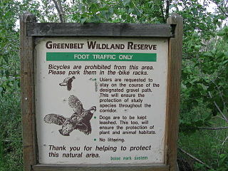
The Boise River Greenbelt is a recreational and alternate transportation trail along the banks of the Boise River through Boise, Idaho, United States. The Boise Greenbelt is more of a greenway than a green belt since its character is linear. It extends more than 20 miles (32 km) beginning at Lucky Peak Dam in the east to a short distance beyond Eagle Road in the west in Eagle, Idaho. Taking into account both sides of the river and other parallel trails and spurs, the total Greenbelt trail system measures more than 30 miles (48 km).

Fontana Dam

Fontana Dam is a hydroelectric dam on the Little Tennessee River in Swain and Graham counties, North Carolina, United States. The dam is operated by the Tennessee Valley Authority, which built the dam in the early 1940s to accommodate the skyrocketing electricity demands in the Tennessee Valley at the height of World War II. At 480 feet (150 m) high, Fontana is the tallest dam in the Eastern United States, and at the time of its construction, it was the fourth tallest dam in the world. The dam and associated infrastructure was listed on the National Register of Historic Places in 2017.

Cardinal Greenway

The Cardinal Greenway (TGC) is a multi-use recreational system combining a rail trail and an on-street route that together cross 62 miles (100 km) and five counties — in east central Indiana. Formerly a CSX rail right of way, the system runs from Richmond to Marion and as of 2018 is Indiana's longest rail trail project.

Greenway (landscape) long piece of land, where vegetation and slow travel are encouraged

A greenway is "a strip of undeveloped land near an urban area, set aside for recreational use or environmental protection". However, the term can in fact include "a scenic road" and though many are in urban areas, there are some rural greenways, as for example the Monadnock-Sunapee Greenway, a hiking trail in southern New Hampshire.

City of Parks is a municipal project to create a continuous paved pedestrian and biking trail around the city of Louisville, Kentucky while also adding a large amount of park land. The project was announced on February 22, 2005. Current plans call for making approximately 4,000 acres (1,600 ha) of the Floyds Fork floodplain in eastern Jefferson County into park space, expanding area in the Jefferson Memorial Forest, and adding riverfront land and wharfs along the Riverwalk Trail and Levee Trail. There are also plans to connect the 100-mile (160 km) Louisville trail to a planned seven mile (11 km) trail connecting the Southern Indiana cities of New Albany, Clarksville and Jeffersonville.

Airport Loop highway in Maryland

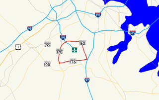
Airport Loop is the designation for the portions of state highways that form a circumferential highway around Baltimore/Washington International Thurgood Marshall Airport in Anne Arundel County in the U.S. state of Maryland. The loop runs 8.44 miles (13.58 km) through the communities of Linthicum, Ferndale, and Hanover. Airport Loop consists of a 3.47-mile (5.58 km) section of Maryland Route 170 along the western and northern sides of the loop; the entire 2.31-mile (3.72 km) length of MD 162 on the eastern side of the loop; and a 2.66-mile (4.28 km) segment of MD 176 on the southern side of the loop. Airport Loop intersects Interstate 195, which provides freeway access to the airport terminal, and is connected to I-695, I-97, and MD 100 via connecting highways. The MD 170 and MD 162 sections of Airport Loop are part of the National Highway System.

The Anacostia Tributary Trail System (ATTS) is a unified and signed system of stream valley trails joining trails along the Anacostia tributaries of Northwest Branch, Northeast Branch, Indian Creek and Paint Branch with a trail along the Anacostia River, set aside and maintained by the Maryland-National Capital Park and Planning Commission (M-NCPPC) in the Maryland suburbs of Washington, D.C.

Trails in Detroit

This is a list of trails and greenways in Detroit.

The South Tar River Greenway is a 3.1 miles (5.0 km) greenway located in Greenville, North Carolina. The northwest terminus trailhead is located at the Town Common. The trail goes east and follows the southern bank of the Tar River, then at the confluence of the Tar River and Green Mill Run, turns south and follows the western edge of the tributary. The southeast terminus trailhead is located at Greensprings Park. This greenway is the second in the city, after the 1.5 miles (2.4 km) Green Mill Run Greenway. The $1,488,000 project is funded from the Federal Highway Administration budget through its inclusion in the Federal FY2005 Appropriations Act.

Parks and Greenways in Huntsville

An extension collection of parks and greenways exists in Huntsville, Alabama for the public's recreational use.

Camp Chase Trail

The Camp Chase Trail is a paved multi-use trail in Madison and Franklin counties in the U.S. state of Ohio. It serves as the Southwest Columbus segment of the 326-mile (525 km) Ohio to Erie Trail. The entire length of the Camp Chase Trail is part of U.S. Bicycle Route 50, a west-east bicycle route across Ohio connecting Indiana to West Virginia.

Cleveland/Bradley County Greenway

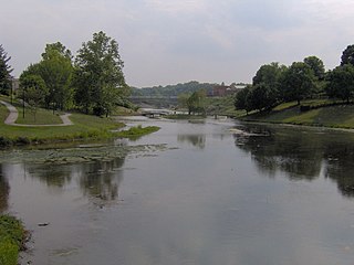
The Cleveland/Bradley County Greenway is a 4-mile-long public greenway walking path in Cleveland, Tennessee maintained by the local Greenway Advisory Board. The path is the longest path in the Greenway Network, a network of public walking trails located in Bradley County, Tennessee.

References

  1. Maryville Alcoa Daily Times Nov 30, 1998; Trail of Two Cities is a landmark of long term effort, cooperation
  2. Maryville Alcoa Daily Times Feb 25, 1999; Enjoying a trek along the Greenway
  3. The Daily Times December 22, 2010 "A new face: Pedestrian bridge gives Alcoa ‘new identity’"

Coordinates: 35°46′48″N83°59′06″W / 35.7801°N 83.9851°W / 35.7801; -83.9851