Maryville, Tennessee

Last updated

Maryville
Maryville-from-Blount-County-tn1.jpg
Skyline with Greenbelt Park below
Flag of Maryville, Tennessee.svg
City of Maryville Logo.jpg
Motto: 
"People are the Key"
Blount County Tennessee Incorporated and Unincorporated areas Maryville Highlighted 4746380.svg
Location of Maryville in Blount County, Tennessee.
Maryville-tn-map.gif
U.S. Census map
Coordinates: 35°44′48″N83°58′44″W / 35.74667°N 83.97889°W / 35.74667; -83.97889
Country United States
State Tennessee
County Blount
Settled1785
Incorporated 1795 [1]
Named for Mary Grainger Blount
Government
  TypeCouncil-manager
  City managerGreg McClain
  MayorAndy White
Area
[2]
  Total17.27 sq mi (44.72 km2)
  Land17.27 sq mi (44.72 km2)
  Water0.00 sq mi (0.00 km2)
Elevation
[3]
981 ft (299 m)
Population
 (2020) [4]
  Total31,907
  Density1,847.86/sq mi (713.48/km2)
Time zone UTC-5 (Eastern (EST))
  Summer (DST) UTC-4 (EDT)
ZIP codes
37801-37804
Area code 865
FIPS code 47-46380 [5]
GNIS feature ID2405036 [3]
Website www.maryvillegov.com

Maryville is a city in and the county seat of Blount County, Tennessee. [6] Its population was 31,907 at the 2020 census. [7]

Contents

History

When the first European explorers arrived in the area, they found the Great Indian Warpath, which ran along the route where the modern US-411 has been built. The trail was long used by the indigenous peoples of the area. A historic Cherokee village known as "Elajay" was situated at the confluence of Ellejoy Creek (named after the village) and the Little River. Its site was near the modern Heritage High School. Ensign Henry Timberlake passed through the village in 1762 while returning from his expedition to the Overhill villages to the west. He reported that it had been abandoned. [8]

Monument marking the spring that once supplied water to Fort Craig Fort-craig-maryville-tennessee.jpg
Monument marking the spring that once supplied water to Fort Craig

In 1785, Revolutionary War veteran John Craig built a wooden palisade enclosing cabins at what is known as Fort Craig (or Craig's Station) in present-day Maryville. Such stations were built throughout the frontier to defend settlers against attacks from the Cherokee. For example, "on April 11, 1793, when settlers believed Indian attacks were imminent, 280 men, women, and children gathered in small huts at John Craig's station on Nine Mile Creek." [9]

Craig donated 50 acres (20 ha) next to his fort for the founding of a new town. Incorporated as a city on July 11, 1795, the settlement was named in honor of Mary Grainger Blount, wife of the territorial governor William Blount. Blount County was named after him. [10]

The family of Sam Houston moved to Maryville from Virginia in 1808, when Houston was 15. His older brothers put him to work as a clerk in a store they established in town, but he ran away. Houston lived for a few years with the Cherokee at Hiwassee Island, on the Hiwassee River, where he became fluent in their language and appreciative of their culture. After his return to Maryville about 1811, Houston started a one-room schoolhouse. He signed up for the army during the War of 1812 and rose rapidly in rank, beginning his military and political career. The schoolhouse still stands just off US-411 near the community of Wildwood.

Sam Houston Schoolhouse in Maryville Sam-houston-school-maryville.jpg
Sam Houston Schoolhouse in Maryville

Maryville was a center of abolitionist activity throughout the early 19th-century; it was generated mostly by the Society of Friends, which had a relatively large presence in Blount County. They were supported by anti-slavery advocates such as Isaac L. Anderson, the founder of Maryville College. [11] When Tennessee voted on the Ordinance of Secession in 1861, only 19 percent of Blount Countians voted in favor of seceding from the Union. [12]

Although staunchly pro-Union throughout the Civil War, Maryville was not liberated by federal troops until May 1864. In August of that year, a Confederate cavalry raid, under the command of General Joseph Wheeler, attacked the courthouse where the Union troops had taken shelter. To try to dislodge the federal soldiers, Confederates set fire to several buildings, including a store where the city's records were being kept. Polly Tool, an African-American slave, rescued most of the records. She was honored by a statue in the Blount County courthouse. In the Reconstruction Era Maryville became a hub of Radical Republican activity for East Tennessee. Its local Union League provided a lively forum for political discussion, [13] and the Freedmen's Normal Institute was established on the present-day site of Maryville High School. The city elected William Bennett Scott Sr., the country's second African-American mayor, in 1869. [14]

Maryville is home to one of 24 Alcoa Care-free Homes built in the United States in 1957–1958. [15]

In the 1970s, after several department stores and other retailers moved from the downtown area to Alcoa's Midland shopping center, the city spent $10 million on a renewal project called "Now Town". Traffic was re-routed, facades were placed on old buildings, slums were cleared, and the Bicentennial Greenbelt Park was created. The project failed to attract business back to the downtown locations; instead retailers moved to the new Foothills Mall a few years later. The downtown area remained in decline until the 2000s, when the city agreed to reverse many of the "Now Town" changes.

U.S. Senator Lamar Alexander was born in Maryville in 1940. Alexander served as Governor of Tennessee from 1979 to 1987 and Secretary of Education (1991–1993) under President George H. W. Bush. He ran unsuccessful campaigns for president in 1996 and 2000, both times announcing his candidacy for the Republican Party from his hometown of Maryville. In 2002, he was elected to the U.S. Senate, succeeding Fred Thompson.

On July 2, 2015, a CSX freight train carrying hazardous materials went off of its tracks. Over 5,000 citizens were displaced from their homes within a two-mile (three kilometer) radius. [16] [17] [18]

Geography

Bicentennial Greenbelt Park Greenbelt-park-bridge-tn1.jpg
Bicentennial Greenbelt Park

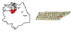
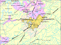
Maryville is located in north-central Blount County in the foothills of the Great Smoky Mountains. Chilhowee Mountain, the outermost ridge of the Western Smokies, rises prominently to the south. Chilhowee's eastern flank known locally as "The Three Sisters" is visible from almost anywhere in the city, and dominates the southern horizon along US-321 between Maryville and Walland. Maryville is bordered on the north by Maryville's twin city, Alcoa. A number of small suburbs including Wildwood, Ellejoy, and Clover Hill surround Maryville to the east and west.

According to the United States Census Bureau, the city has a total area of 16.8 square miles (43.5 km2), all land. [19]

Major streets

Parks

Sandy Springs Park S Springs Park.jpg
Sandy Springs Park

Climate

Average temperatures in July range from 69 degrees low to 87 degrees high. Average temperatures in January range from 29 degrees low to 46 degrees high. [20] Most of the year is very pleasant with mild temperatures.

Demographics

Historical population
CensusPop.Note
1850 513
1860 493−3.9%
1870 81164.5%
1880 1,09835.4%
1890 1,68653.6%
1910 2,381
1920 3,73957.0%
1930 4,95832.6%
1940 5,60913.1%
1950 7,74238.0%
1960 10,34833.7%
1970 13,80833.4%
1980 17,48026.6%
1990 19,2089.9%
2000 23,12020.4%
2010 27,46518.8%
2020 31,90716.2%
Sources: [21] [22] [4]

2020 census

Maryville racial composition [23]
RaceNumberPercentage
White (non-Hispanic)27,12285.0%
Black or African American (non-Hispanic)9442.96%
Native American 650.2%
Asian 6321.98%
Pacific Islander 50.02%
Other/Mixed 1,5004.7%
Hispanic or Latino 1,6395.14%

As of the 2020 United States census, there were 31,907 people, 10,719 households, and 7,132 families residing in the city.

2010 census

As of the census [5] of 2010, there were 27,465 people, 10,712 households, and 7,028 families. The population density was 1,634.8 inhabitants per square mile (631.2/km2). There were 11,679 housing units at an average density of 637.6 per square mile (246.2/km2). The racial makeup of the city was 92.0% White, 3.2% Black, 0.3% Native American, 1.55% Asian, 0.03% Pacific Islander, 0.53% from other races, and 1.8% from two or more races. Hispanic or Latino of any race were 3.2% of the population.

There were 10,712 households, out of which 32.0% had children under the age of 18 living with them, 48.6% were married couples living together, 12.8% had a female householder with no husband present, and 34.4% were non-families. 30.4% of all households were made up of individuals, and 29.7% had someone living alone who was 65 years of age or older. The average household size was 2.41 and the average family size was 3.00.

In the city, the population was spread out, with 24.2% under the age of 18, 6.8% from 20 to 24, 24.2% from 25 to 44, 24.4% from 45 to 64, and 17.1% who were 65 years of age or older. The median age was 39.1 years. For every 100 females, there were 88.0 males.

The median income for a household in the city was $46,394, and the median income for a family was $61,227. Males had a median income of $31,478 versus $20,418 for females. The per capita income for the city was $23,579. About 9.0% of families and 10.2% of the population were below the poverty line, including 12.3% of those under age 18 and 3.1% of those age 65 or over.

Economy

Top employers

According to Maryville's 2020 Comprehensive Annual Financial Report, [24] the top employers in the area were:

#Employer# of Employees
1 Denso 5,350
2 Clayton Homes 4,883
3Blount Memorial Hospital2,647
4 McGhee Tyson Air National Guard Base 1,728
5 Blount County Schools 1,701
6 Newell Brands 1,000
7 Arconic (formerly Alcoa, Inc.)898
8Blount County Government774
9Maryville City Schools708
10 Walmart 610
11Accenture Hospitality Service541
12TeamHealth Alcoa Billing Center451
13 Ruby Tuesday 475
14Massey Group405
15 Maryville College 380
16Reinhart Food Service (formerly IJ Co.)344
17City of Maryville321
18Standard Aero Inc.335
19Rockford Manufacturing300
20City of Alcoa275
21K12265
22Alcoa City Schools344
23Peninsula Hospital, Division of Covenant Health317

Education

City

Maryville City Schools operates public schools.

Private or parochial

Maryville College

Maryville is home to Maryville College, a private four-year liberal arts college. It was founded in 1819 by Presbyterian minister Isaac L. Anderson for the purpose of furthering education and enlightenment and whose mission was to do good on the largest possible scale. The college is one of the fifty oldest colleges in the United States and the twelfth oldest institution in the South. [25] It is associated with the Presbyterian Church (USA). It enrolls about 1,103 students. Maryville College's mascot is the Scots. The sports teams compete in NCAA Division III athletics in the USA South Athletic Conference and formerly the Great South Athletic Conference.

Other colleges

Weekend programs

The East Tennessee Japanese School (イーストテネシー補習授業校 Īsuto Teneshī Hoshū Jugyō Kō), a weekend Japanese education program, holds its classes at Maryville College. [26]

Notable people

See also

Related Research Articles

<span class="mw-page-title-main">Blount County, Tennessee</span> County in Tennessee, United States

Blount County is a county located in the East Tennessee Grand Division of the U.S. state of Tennessee. As of the 2020 census, its population was 135,280. The county seat is Maryville, which is also the county's largest city. Blount County is included in the Knoxville metropolitan area.

<span class="mw-page-title-main">Fox Chapel, Pennsylvania</span> Borough in Pennsylvania, United States

Fox Chapel is a borough in Allegheny County, Pennsylvania, United States. It is a suburb of Pittsburgh located 6 miles (10 km) northeast of downtown. The population was 5,343 as of the 2020 census. The borough continually garners national prominence and is home to many of the wealthiest and most powerful patriciate families in Pennsylvania.

<span class="mw-page-title-main">Alcoa, Tennessee</span> City in Tennessee, United States

Alcoa is a city in Blount County, Tennessee, United States. Its population was 10,978 at the 2020 census. It is part of the Knoxville, TN Metropolitan Statistical Area.

<span class="mw-page-title-main">Friendsville, Tennessee</span> City in Tennessee, United States

Friendsville is a city in Blount County, Tennessee. Its population was 896 at the 2020 census. It is included in the Knoxville, Tennessee Metropolitan Statistical Area.

<span class="mw-page-title-main">Louisville, Tennessee</span> Town in Tennessee, United States

Louisville is a suburban town in Blount County, Tennessee. Its population was 4,384 at the 2020 census. It is included in the Knoxville, Tennessee Metropolitan Statistical Area.

<span class="mw-page-title-main">Rockford, Tennessee</span> City in Tennessee, United States

Rockford is a city in Blount County, Tennessee. Its population was 822 at the 2020 census. It is included in the Knoxville, Tennessee Metropolitan Statistical Area.

<span class="mw-page-title-main">Townsend, Tennessee</span> City in Tennessee, United States

Townsend is a city in Blount County, Tennessee. The city was chartered in 1921 by persons who were involved with the Little River Railroad and Lumber Company. The population was 550 at the 2020 census. For thousands of years a site of Native American occupation by varying cultures, Townsend is one of three "gateways" to the Great Smoky Mountains National Park. It has several museums and attractions relating to the natural and human history of the Great Smokies.

<span class="mw-page-title-main">Knoxville, Tennessee</span> City in Tennessee, United States

Knoxville is a city in and the county seat of Knox County, Tennessee, United States. As of the 2020 United States census, Knoxville's population was 190,740, making it the largest city in the East Tennessee Grand Division and the state's third-most-populous city after Nashville and Memphis. It is the principal city of the Knoxville metropolitan area, which had a population of 879,773 in 2020.

<span class="mw-page-title-main">Greenback, Tennessee</span> City in Tennessee, United States

Greenback is a city in Loudon County, Tennessee, United States. Its population was at 1,102, according to the 2020 census. It is included in the Knoxville Metropolitan Statistical Area.

Daleville is a census-designated place (CDP) in southern Botetourt County, Virginia, United States. The population was 3,070 at the 2020 census. The CDP is located along U.S. Route 220. It is part of the Roanoke Metropolitan Statistical Area.

<span class="mw-page-title-main">Seymour, Tennessee</span> CDP in Tennessee, United States

Seymour is a census-designated place (CDP) and unincorporated community in Blount and Sevier counties in the U.S. state of Tennessee. The CDP population was 14,705 at the 2020 U.S. census. It is included in the Knoxville, Tennessee Metropolitan Statistical Area.

<span class="mw-page-title-main">Maryville College</span> Private liberal arts college in Maryville, Tennessee, US

Maryville College is a private liberal arts college in Maryville, Tennessee. It was founded in 1819 by Presbyterian minister Isaac L. Anderson for the purpose of furthering education and enlightenment into the West. The college is one of the 50 oldest colleges in the United States and the 12th-oldest institution in the South. It is associated with the Presbyterian Church (USA) and enrolls about 1,100 students. Its mascot is the Scots, and sports teams compete in NCAA Division III athletics in the Collegiate Conference of the South.

<span class="mw-page-title-main">Japanese in the United Kingdom</span> Ethnic group

Japanese in the United Kingdom include British citizens of Japanese ancestry or permanent residents of Japanese birth or citizenship, as well as expatriate business professionals and their dependents on limited-term employment visas, students, trainees and young people participating in the UK government-sponsored Youth Mobility Scheme.

<span class="mw-page-title-main">Maryville Alcoa Greenway</span>

The Maryville Alcoa Greenway is a cooperative effort by the two cities and Blount County, Tennessee to connect existing parks with a paved foot and cycle path.

<span class="mw-page-title-main">Pistol Creek</span>

Pistol Creek is a 13-mile-long (21 km) tributary of the Little River, located entirely within Blount County, Tennessee.

<span class="mw-page-title-main">Walland, Tennessee</span> CDP in Tennessee, United States

Walland is an unincorporated community and census-designated place (CDP) in Blount County, Tennessee. Its population was 281 as of the 2020 census. Walland is the site of a post office and is the place name associated with zip code 37886, which covers an area beyond the Walland community.

<span class="mw-page-title-main">U.S. Route 129 in Tennessee</span> Segment of American highway

U.S. Route 129 is a north–south United States highway that runs for 52.8 miles (85.0 km) in East Tennessee, from the North Carolina state line, near Tapoco, to Knoxville. In Tennessee, the highway is completely overlapped by unsigned State Route 115. In the Greater Knoxville area, US 129 serves as a six-lane controlled-access highway known as Alcoa Highway.

<span class="mw-page-title-main">South Knoxville</span>

South Knoxville is the section of Knoxville, Tennessee, United States, that lies south of the Tennessee River. It is concentrated along Chapman Highway, Alcoa Highway, Maryville Pike, Sevierville Pike, and adjacent roads, and includes the neighborhoods of Lindbergh Forest, Island Home Park, Old Sevier, South Haven, Vestal, Lake Forest, South Woodlawn and Colonial Village. South Knoxville is connected to Downtown Knoxville via four vehicle bridges: the James C. Ford Memorial Bridge, the Gay Street Bridge, the Henley Bridge, by some incorrectly called the Henley Street Bridge, and the J. E. "Buck" Karnes Bridge. Parts of South Knoxville were annexed by Knoxville in 1917.

<span class="mw-page-title-main">Tennessee State Route 335</span> State highway in Tennessee, United States

State Route 335 is an 11-mile-long (18 km) north–south state highway in Blount County, Tennessee. It forms a semicircle around the western half of the Maryville-Alcoa metro area.

References

  1. Tennessee Blue Book , 2005-2006, pp. 618-625.
  2. "ArcGIS REST Services Directory". United States Census Bureau. Retrieved October 15, 2022.
  3. 1 2 U.S. Geological Survey Geographic Names Information System: Maryville, Tennessee
  4. 1 2 "Census Population API". United States Census Bureau. Retrieved October 15, 2022.
  5. 1 2 "U.S. Census website". United States Census Bureau . Retrieved January 31, 2008.
  6. "Find a County". National Association of Counties. Retrieved June 7, 2011.
  7. "Quickfacts: Maryville city, Tennessee". United States Census Bureau . Retrieved December 24, 2021.
  8. Henry Timberlake, Samuel Williams (ed.), Memoirs, 1756-1765 (Marietta, Georgia: Continental Book Co., 1948), pp. 118-119.
  9. Walter Durham, "Frontier Stations", Tennessee Encyclopedia of History and Culture, accessed August 27, 2010
  10. Inez Burns, History of Blount County, Tennessee: From War Trail to Landing Strip, 1795-1955 (Nashville: Benson Print Co., 1957), 2-30.
  11. Durwood Dunn, Cades Cove: The Life and Death of an Appalachian Community, Knoxville, TN: University of Tennessee Press, 1988, 125.
  12. Oliver Perry Temple, East Tennessee and the Civil War (R. Clarke Company, 1899), p. 199.
  13. Snay, Mitchell (2010) Fenians, Freedmen, and Southern Whites: Race and Nationality in the Era of Reconstruction
  14. "Maryville Historic Timeline" Archived February 2, 2009, at the Wayback Machine , City of Maryville
  15. Oxenham, Andrew (August 19, 2020). "The ALCOA Care-Free Home by Charles M. Goodman, Mid Century Modern Tennessee".
  16. "U.S. News - National News". ABC News.
  17. "Train Carrying 'Flammable and Toxic Gas' Derails, Burns". NBC News .
  18. "Quick Links". CNN.
  19. "Geographic Identifiers: 2010 Demographic Profile Data (G001): Maryville city, Tennessee". U.S. Census Bureau, American Factfinder. Archived from the original on February 12, 2020. Retrieved April 8, 2014.
  20. Weather.com. Retrieved: September 4, 2011.
  21. "Census of Population and Housing: Decennial Censuses". United States Census Bureau . Retrieved March 4, 2012.
  22. "Incorporated Places and Minor Civil Divisions Datasets: Subcounty Resident Population Estimates: April 1, 2010 to July 1, 2012". Population Estimates. U.S. Census Bureau. Archived from the original on June 11, 2013. Retrieved December 11, 2013.
  23. "Explore Census Data". data.census.gov. Retrieved December 26, 2021.
  24. City of Maryville Comprehensive Annual Financial Report. Retrieved: December 19, 2020.
  25. Maryville College website. Retrieved: September 4, 2011.
  26. "補習授業校リスト" (Archive). Consulate General of Japan in Nashville. Retrieved on February 15, 2015. "(2)イーストテネシー補習授業校 ( East Tennessee Japanese School ) 学校所在地  c/o Maryville College 502 E. Lamar Alexander Parkway, Maryville, TN 37804"
  27. "Meet Lamar". Alexander for Senate. Retrieved September 9, 2010.
  28. Robert Booker, Charles Warner Cansler, Tennessee Encyclopedia of History and Culture, 2009. Retrieved: April 6, 2011.
  29. Mike Cross biography from official website. Retrieved: February 14, 2011.
  30. Johnson Bible College - Our History Archived February 6, 2011, at the Wayback Machine . Retrieved: February 14, 2011.
  31. Jack Greene - Official site Archived February 2, 2011, at the Wayback Machine . Retrieved: February 14, 2011.
  32. M. Thomas Inge, High Times and Hard Times (Nashville: Vanderbilt University Press, 1967), p. 18n.
  33. Sam Houston - Chronology. Retrieved: February 14, 2011.
  34. Lee Humphrey - ESPN player profile. Retrieved: February 14, 2011.
  35. IMDb - Melanie Hutsell. Retrieved: February 14, 2011.
  36. Kevin Cowan, "Attorney's New Home Christened in Festive Fashion," Knoxville News Sentinel, January 13, 2008. Retrieved: August 24, 2012.
  37. "Annie E. Law". The Nautilus: 132–133.
  38. Steve Wildsmith, "Doc Severinsen, ‘Murvul’ boy: Former ‘Tonight Show’ bandleader now calls Blount County home," The Daily Times, April 10, 2013. Retrieved: May 8, 2021.