Seymour | |
|---|---|
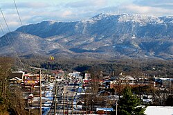 Seymour, with Chapman Highway on the left and Bluff Mountain in the distance; the towers sit on the summit, 2010 | |
| Motto: "Gorgeous Views, Great People" | |
 Location of Seymour, Tennessee | |
| Coordinates: 35°52′42″N83°46′01″W / 35.87833°N 83.76694°W | |
| Country | United States |
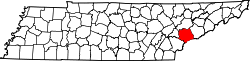
| State | Tennessee |
| Counties | Sevier, Blount |
| Area | |
• Total | 16.03 sq mi (41.51 km2) |
| • Land | 16.02 sq mi (41.49 km2) |
| • Water | 0.0077 sq mi (0.02 km2) |
| Elevation | 1,211 ft (369 m) |
| Population | |
• Total | 14,705 |
| • Density | 917.9/sq mi (354.42/km2) |
| Time zone | UTC-5 (Eastern (EST)) |
| • Summer (DST) | UTC-4 (EDT) |
| ZIP code | 37865 |
| Area code | 865 |
| FIPS code | 47-67200 [4] |
| GNIS feature ID | 2402842 [2] |
| Website | seymourtn |
Seymour is a census-designated place (CDP) and unincorporated community in Blount and Sevier counties in the U.S. state of Tennessee. The CDP population was 14,705 at the 2020 U.S. census. [5] It is part of the Knoxville, Tennessee Metropolitan Statistical Area.