Shelbyville, Tennessee

Last updated

Shelbyville
Shelbyville Tennessee.JPG
Downtown Shelbyville
Nickname(s): 
The Walking Horse Capital of the World and The Pencil City
Bedford County Tennessee Incorporated and Unincorporated areas Shelbyville Highlighted 4767760.svg
Location of Shelbyville in Bedford County, Tennessee.
Coordinates: 35°29′20″N86°27′8″W / 35.48889°N 86.45222°W / 35.48889; -86.45222
Country United States
State Tennessee
County Bedford
Platted 1810
Incorporated1819
Named for Isaac Shelby [1]
Government
  MayorWallace Cartright
Area
[2]
  Total18.44 sq mi (47.76 km2)
  Land18.44 sq mi (47.76 km2)
  Water0.00 sq mi (0.00 km2)
Elevation
755 ft (230 m)
Population
 (2020) [3]
  Total23,557
  Density1,277.56/sq mi (493.27/km2)
Time zone UTC-6 (Central (CST))
  Summer (DST) UTC-5 (CDT)
ZIP codes
37160-37162
Area code 931
FIPS code 47-67760 [4]
GNIS feature ID1269993 [5]
Website www.shelbyvilletn.org

Shelbyville is a city in and the county seat of Bedford County, Tennessee. [6] The town was laid out in 1810 and incorporated in 1819. [7] Shelbyville had a population of 20,335 residents at the 2010 census. [8] The town is a hub of the Tennessee Walking Horse industry and has been nicknamed "The Walking Horse Capital of the World".

Contents

Geography

Shelbyville is in Middle Tennessee on a Highland Rim limestone bluff upon the banks of Duck River, which flows around the southern and eastern sides of town. [9]

According to the United States Census Bureau, the city has a total area of 18.6 square miles (48.2 km2), all land. [8]

Climate

Climate data for Shelbyville, Tennessee (1991–2020 normals, extremes 1951–present)
MonthJanFebMarAprMayJunJulAugSepOctNovDecYear
Record high °F (°C)78
(26)
82
(28)
85
(29)
92
(33)
96
(36)
108
(42)
107
(42)
105
(41)
105
(41)
98
(37)
87
(31)
77
(25)
108
(42)
Mean maximum °F (°C)67.5
(19.7)
71.2
(21.8)
78.8
(26.0)
84.1
(28.9)
89.1
(31.7)
94.0
(34.4)
95.9
(35.5)
95.7
(35.4)
93.1
(33.9)
85.7
(29.8)
77.5
(25.3)
69.0
(20.6)
97.5
(36.4)
Mean daily maximum °F (°C)49.4
(9.7)
53.8
(12.1)
62.5
(16.9)
72.0
(22.2)
79.5
(26.4)
86.4
(30.2)
89.4
(31.9)
89.0
(31.7)
83.9
(28.8)
73.4
(23.0)
61.6
(16.4)
52.4
(11.3)
71.1
(21.7)
Daily mean °F (°C)39.1
(3.9)
42.7
(5.9)
50.6
(10.3)
59.5
(15.3)
67.8
(19.9)
75.4
(24.1)
78.8
(26.0)
77.8
(25.4)
71.8
(22.1)
60.6
(15.9)
49.3
(9.6)
42.0
(5.6)
59.6
(15.3)
Mean daily minimum °F (°C)28.9
(−1.7)
31.7
(−0.2)
38.7
(3.7)
47.1
(8.4)
56.2
(13.4)
64.3
(17.9)
68.3
(20.2)
66.6
(19.2)
59.7
(15.4)
47.9
(8.8)
37.1
(2.8)
31.7
(−0.2)
48.2
(9.0)
Mean minimum °F (°C)9.7
(−12.4)
14.9
(−9.5)
21.3
(−5.9)
30.1
(−1.1)
40.4
(4.7)
52.9
(11.6)
59.4
(15.2)
57.4
(14.1)
44.6
(7.0)
31.6
(−0.2)
21.7
(−5.7)
16.0
(−8.9)
7.7
(−13.5)
Record low °F (°C)−20
(−29)
−7
(−22)
3
(−16)
21
(−6)
30
(−1)
38
(3)
49
(9)
47
(8)
32
(0)
18
(−8)
9
(−13)
−9
(−23)
−20
(−29)
Average precipitation inches (mm)5.29
(134)
5.63
(143)
5.79
(147)
4.99
(127)
5.05
(128)
5.03
(128)
5.07
(129)
4.24
(108)
4.22
(107)
3.65
(93)
4.35
(110)
6.05
(154)
59.36
(1,508)
Average snowfall inches (cm)0.1
(0.25)
0.2
(0.51)
0.7
(1.8)
0.0
(0.0)
0.0
(0.0)
0.0
(0.0)
0.0
(0.0)
0.0
(0.0)
0.0
(0.0)
0.0
(0.0)
0.0
(0.0)
0.1
(0.25)
1.1
(2.8)
Average precipitation days (≥ 0.01 in)11.611.812.411.111.711.311.39.37.88.49.612.1128.4
Average snowy days (≥ 0.1 in)0.20.30.30.00.00.00.00.00.00.00.00.21.0
Source: NOAA [10] [11]

Demographics

Historical population
CensusPop.Note
1850 1,708
1860 776−54.6%
1870 1,719121.5%
1880 1,8698.7%
1890 1,823−2.5%
1900 2,23622.7%
1910 2,86928.3%
1920 2,9121.5%
1930 5,01072.0%
1940 6,53730.5%
1950 9,45644.7%
1960 10,46610.7%
1970 12,26217.2%
1980 13,53010.3%
1990 14,0493.8%
2000 16,10514.6%
2010 20,33526.3%
2020 23,55715.8%
Sources: [12] [13] [3]

2020 census

Shelbyville racial composition [14]
RaceNumberPercentage
White (non-Hispanic)13,15655.85%
Black or African American (non-Hispanic)2,94212.49%
Native American 650.28%
Asian 1730.73%
Pacific Islander 100.04%
Other/Mixed 1,0454.44%
Hispanic or Latino 6,16626.17%

As of the 2020 United States census, there were 23,557 people, 7,257 households, and 5,025 families residing in the city.

2000 census

As of the census [4] of 2000, there were 16,105 people, 6,066 households, and 4,155 families residing in the city. The population density was 1,041.3 inhabitants per square mile (402.0/km2). There were 6,550 housing units at an average density of 423.5 per square mile (163.5/km2). The racial makeup of the city was 77.14% White, 14.98% African American, 0.70% Asian, 0.35% Native American, 0.05% Pacific Islander, 5.02% from other races, and 1.78% from two or more races. Hispanics or Latinos of any race made up 14.55% of the population.

Of the 6,066 households, 31.7% had children under the age of 18 living with them, 46.0% were married couples living together, 16.6% had a female householder with no husband present, and 31.5% were non-families. A total of 26.5% of all households were made up of individuals, and 12.4% had someone living alone who was 65 years of age or older. The average household size was 2.59 and the average family size was 3.05.

In the city, the population was spread out, with 25.2% under the age of 18, 11.9% from 18 to 24, 28.9% from 25 to 44, 18.8% from 45 to 64, and 15.2% who were 65 years of age or older. The median age was 34 years. For every 100 females, there were 94.4 males. For every 100 females age 18 and over, there were 91.5 males.

The median income for a household in the city was $27,593, and the median income for a family was $30,465. Males had a median income of $23,754 versus $16,065 for females. The per capita income for the city was $11,260. About 14.4% of families and 25.2% of the population were below the poverty line, including 18.4% of those under age 18 and 22.1% of those age 65 or over.

Economy

Town Square of Shelbyville Shelbyville Tennessee square.jpg
Town Square of Shelbyville

Shelbyville is known as "The Pencil City" because of its historical importance as a center of wood-cased pencil manufacturing. [15] [16] It is still a site for manufacture of writing instruments. In 1982, National Pen Corporation purchased its largest competitor, U.S. Pencil and Stationery Company. [17] Sanford Corporation produced the Sharpie, the world's top-selling writing instrument, in the city. [16] It was in Shelbyville in 1991 that the world's longest pencil was produced, a plastic-cased pencil 1,091 feet (333 m) long, weighing 27 pounds (12 kg). [18]

Other major business operations in Shelbyville include manufacturers Calsonic Kansei, Newell Rubbermaid, Cebal America, and Jostens; it is also home to a Tyson Foods facility and a distribution center for Wal-Mart, as well as several nationwide trucking businesses. [16] [19]

Transportation

Shelbyville is at the intersection of U.S. Route 231 and U.S. Route 41A. It was the terminus of a branch line (from Wartrace [20] ), located along what is now known as Railroad Avenue, connecting with what was once known as the Saint Louis, Nashville and Chattanooga Railroad. [9]

Tennessee Walking Horse National Celebration

The Tennessee Walking Horse National Celebration [21] takes place each year during the 11 days and nights prior to Labor Day. It is the largest show for the Tennessee Walking Horse, during which the breed's World Grand Champion and over 20 World Champions are named. The Celebration is a festival event where more than $650,000 in prizes and awards are given. The Celebration began in 1939, and the first winner was Strolling Jim. [22]

Education

K-12 education

Bedford County School District operates primary and secondary schools. Shelbyville Central High School is the local public high school.

After the end of non-penal slavery in the United States the AME Church opened a school for African-American children. The public school system graduated its first black class in 1890. The schools for African-American children operated by the district were East Bedford School and Bedford County Training School for Negroes (a.k.a. John McAdams High School and also Harris High School for Negroes). Schools racially integrated after 1964. [23]

Higher education

The Tennessee College of Applied Technology - Shelbyville is one of 46 institutions in the Tennessee Board of Regents System, the seventh largest system of higher education in the nation. This system comprises six universities, fourteen community colleges, and twenty-six technology centers. More than 80 percent of all Tennessee students attending public institutions are enrolled in a Tennessee Board of Regents institution.

Local government

Shelbyville City Hall. Shelbyville City Hall.JPG
Shelbyville City Hall.

The City of Shelbyville, Tennessee Government consists of an elected mayor, six member elected city council, and appointed city manager. [24]

Public media and news outlets

Shelbyville has one news media outlet, the Shelbyville Times-Gazette. [25]

Notable people

Congressman Jim Cooper. Jim Cooper, Official Portrait, ca2013.jpg
Congressman Jim Cooper.

Shelbyville was featured in Miranda Lambert's video "Famous in a Small Town".[ citation needed ]

The city was also profiled in the film Welcome to Shelbyville , as part of the PBS documentary film series Independent Lens. The film spotlights recent demographic changes in the community, with a focus on the growing number of immigrants from Latin America and Somalia (both Somalis and people from the Bantu minority ethnic group).

Shelbyville was also featured in GADA film's Our Very Own (2005 Film), directed by Cameron Watson. The film, dubbed "a love story to Shelbyville", highlighted some of the peculiar and humorous memories of Shelbyville in the 1970s. The film follows five teenagers who are determined to meet Shelbyville's own Sondra Locke. Filmed in 2004, it highlights the square, Capri Theater, Pope's Cafe, Central High School, Duck River Dam, TWHNC, and many other landmarks.

Shelbyville was mentioned in the lyrics of Nashville country duo Birdcloud's song "Saving Myself For Jesus"

Related Research Articles

<span class="mw-page-title-main">Moore County, Tennessee</span> County in Tennessee, United States

Moore County is a county located in the south central part of the U.S. state of Tennessee. As of the 2020 census, the population was 6,461, making it the third-least populous county in Tennessee. It forms a consolidated city-county government with its county seat of Lynchburg. At 130 square miles (340 km2), it is the second-smallest county in Tennessee, behind only Trousdale. The county was created in 1871, during the Reconstruction era. Moore County is part of the Tullahoma-Manchester, TN Micropolitan Statistical Area.

<span class="mw-page-title-main">Marshall County, Tennessee</span> County in Tennessee, United States

Marshall County is a county located in the U.S. state of Tennessee. As of the 2020 census, the population was 34,318. Its county seat is Lewisburg. Marshall County comprises the Lewisburg Micropolitan Statistical Area, which is also included in the Nashville-Davidson–Murfreesboro–Franklin, TN Metropolitan Statistical Area. It is in Middle Tennessee, one of the three Grand Divisions of the state.

<span class="mw-page-title-main">Lincoln County, Tennessee</span> County in Tennessee, United States

Lincoln County is a county located in the south central part of the U.S. state of Tennessee. As of the 2020 census, the population was 35,319. Its county seat and largest city is Fayetteville. The county is named for Major General Benjamin Lincoln, an officer in the American Revolutionary War.

<span class="mw-page-title-main">Bedford County, Tennessee</span> County in Tennessee, United States

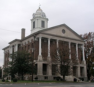
Bedford County is a county located in the U.S. state of Tennessee. As of the 2020 census, the population was 50,237. Its county seat is Shelbyville. Bedford County comprises the Shelbyville, TN Micropolitan Statistical Area, which is also included in the Nashville-Davidson-Murfreesboro, TN Combined Statistical Area.

<span class="mw-page-title-main">Shelbyville, Kentucky</span> City in Kentucky, United States

Shelbyville is a home rule-class city in and the county seat of Shelby County, Kentucky, United States. The population was 17,282 at the 2020 census.

<span class="mw-page-title-main">Bell Buckle, Tennessee</span> Town in Tennessee, United States

Bell Buckle is a town in Bedford County, Tennessee, United States. The population was 410 at the 2020 census. The downtown area is listed on the National Register of Historic Places as the Bell Buckle Historic District.

<span class="mw-page-title-main">Wartrace, Tennessee</span> Town in Tennessee, United States

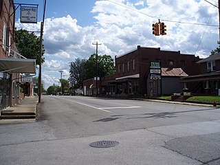
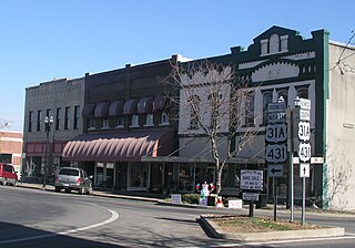
Wartrace is a town in Bedford County, Tennessee. The population was 653 at the 2020 census. It is located northeast of Shelbyville. The downtown area is listed on the National Register of Historic Places as the Wartrace Historic District.

<span class="mw-page-title-main">Camden, Tennessee</span> City in Tennessee, United States

Camden is a city in Benton County, Tennessee. The population was 3,674 at the 2020 census. It is the county seat of Benton County.

<span class="mw-page-title-main">Oak Hill, Tennessee</span> City in Tennessee, United States

Oak Hill is a city in Davidson County, Tennessee. The population was 4,529 at the 2010 census. The Tennessee Governor's Mansion is located in the city. Although the city is administered under the Metropolitan Government of Nashville and Davidson County, it retains its own municipal government.

<span class="mw-page-title-main">Pulaski, Tennessee</span> City in Tennessee, United States

Pulaski is a city in and the county seat of Giles County, which is located on the central-southern border of Tennessee, United States. The population was 8,397 at the 2020 census. It was named after Casimir Pulaski, a noted Polish-born general on the Patriot side in the American Revolutionary War.

<span class="mw-page-title-main">Chapel Hill, Tennessee</span> Town in Tennessee, United States

Chapel Hill is a town in northeastern Marshall County, Tennessee, United States. The town was named after Chapel Hill, North Carolina, by settlers from that area. The population was 1,717 as of the 2020 census.

<span class="mw-page-title-main">Lewisburg, Tennessee</span> City in Tennessee, United States

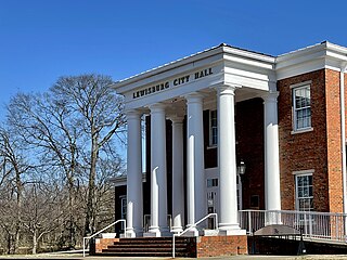
Lewisburg is a city in, and the county seat of Marshall County, Tennessee, United States. The population was 12,288 in 2020. Lewisburg is located in Middle Tennessee, fifty miles south of Nashville and fifty-two miles north of Huntsville, Alabama. Residents have access to the larger cities via nearby I-65.

<span class="mw-page-title-main">Greenbrier, Tennessee</span> City in Tennessee, United States

Greenbrier is a city in Robertson County, Tennessee, United States. The population was 6,433 at the 2010 census, and at the 2020 census the population was 6,898.

<span class="mw-page-title-main">Brentwood, Tennessee</span> City in Tennessee, United States

Brentwood is a city in Williamson County, Tennessee, United States. The population was 45,373 as of the 2020 United States census. It is a suburb of Nashville and included in the Nashville metropolitan area.

<span class="mw-page-title-main">Mount Juliet, Tennessee</span> City in Tennessee, United States

Mt. Juliet is a city located in western Wilson County, Tennessee, United States. A suburb of Nashville, it is approximately 17 miles (27 km) east of downtown Nashville. Mt. Juliet is located mostly between two major national east-west routes, Interstate 40 and U.S. Route 70. As of the 2020 United States census, Mount Juliet has a population of approximately 39,289 people. Mt. Juliet is the largest city in Wilson County. The official city charter has the name listed as Mt. Juliet; however, the United States Postal Service lists its name as Mount Juliet.

<span class="mw-page-title-main">Lynchburg, Tennessee</span> Consolidated city-county in Tennessee, United States

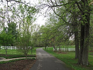
Lynchburg is a city in the south-central region of the U.S. state of Tennessee. It is governed by a consolidated city-county government unit whose boundaries coincide with those of Moore County. Lynchburg is best known as the location of Jack Daniel's distillery, whose famous Tennessee whiskey is marketed worldwide as the product of a city with only one traffic light. Despite the operational distillery, which is a major tourist attraction, Lynchburg's home county of Moore is a dry county. Sampling whiskey is permitted in the distillery, however. The population was 6,461 at the 2020 census.

<span class="mw-page-title-main">White House, Tennessee</span> City in Tennessee, United States

White House is a city in Robertson and Sumner counties in the United States state of Tennessee. The population was listed as 12,982 in the 2020 census. It is approximately twenty-two miles north of downtown Nashville.

<span class="mw-page-title-main">Prentice Cooper</span> American politician

William Prentice Cooper Jr. was an American politician and diplomat who served as the 39th governor of Tennessee from 1939 to 1945. He led the state's mobilization efforts for World War II, when over 300,000 Tennesseans joined the armed forces, and numerous defense-related facilities were established across the state. He later served as United States Ambassador to Peru (1946–1948), and chaired Tennessee's 1953 constitutional convention.

<span class="mw-page-title-main">Tennessee Walking Horse National Celebration</span> Annual horse show in Shelbyville, Tennessee

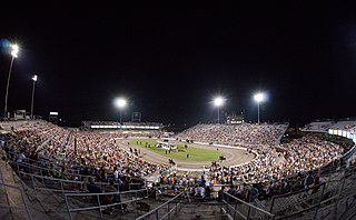
The Tennessee Walking Horse National Celebration (TWHNC), sometimes known as the Celebration, is the largest horse show for the Tennessee Walking Horse breed, and has been held annually in or near Shelbyville, Tennessee since its inception in 1939. The Celebration was conceived by Henry Davis, a horse trainer who along with several other horsemen, felt the Shelbyville area should have a festival or annual event. Although the Celebration was originally held in Wartrace, Tennessee, it moved to Shelbyville, the seat of Bedford County, a few years later. The Celebration spans 11 days and nights in late August and early September annually, and finishes with the crowning of the World Grand Champion Tennessee Walker on the Saturday night before Labor Day. The TWHNC draws an estimated 2,000 horses and 250,000 spectators to Shelbyville each year.

<span class="mw-page-title-main">Horse industry in Tennessee</span>

The horse industry in Tennessee is the 6th largest in the United States, and over 3 million acres of Tennessee farmland are used for horse-related activities. The most popular breed in the state is the Tennessee Walking Horse - developed by crossing Thoroughbred, Morgan, Saddlebred, and Standardbred horses in the 19th and 20th centuries - and it became an official state symbol in 2000.

References

  1. "History of Bedford County". Archived from the original on November 10, 2013. Retrieved February 7, 2013.
  2. "ArcGIS REST Services Directory". United States Census Bureau. Retrieved October 15, 2022.
  3. 1 2 "Census Population API". United States Census Bureau. Retrieved October 15, 2022.
  4. 1 2 "U.S. Census website". United States Census Bureau . Retrieved January 31, 2008.
  5. "US Board on Geographic Names". United States Geological Survey. October 25, 2007. Retrieved January 31, 2008.
  6. "Find a County". National Association of Counties. Retrieved June 7, 2011.
  7. History of Tennessee from the Earliest Time to the Present. Goodspeed Publishing Company. 1886. pp.  873–874.
  8. 1 2 "Geographic Identifiers: 2010 Demographic Profile Data (G001): Shelbyville city, Tennessee". U.S. Census Bureau, American Factfinder. Archived from the original on February 12, 2020. Retrieved April 8, 2014.
  9. 1 2 "Chapter VIII: Tennessee Group - Bedford County". Narrative of Cholera Epidemic of 1873. U.S. Government Printing Office. 1875. p. 163.
  10. "NowData - NOAA Online Weather Data". National Oceanic and Atmospheric Administration. Retrieved October 2, 2021.
  11. "Station: Shelbyville Water Dept, TN". U.S. Climate Normals 2020: U.S. Monthly Climate Normals (1991-2020). National Oceanic and Atmospheric Administration. Retrieved October 2, 2021.
  12. "Census of Population and Housing: Decennial Censuses". United States Census Bureau . Retrieved March 4, 2012.
  13. "Incorporated Places and Minor Civil Divisions Datasets: Subcounty Resident Population Estimates: April 1, 2010 to July 1, 2012". Population Estimates. U.S. Census Bureau. Archived from the original on June 11, 2013. Retrieved December 11, 2013.
  14. "Explore Census Data". data.census.gov. Retrieved December 24, 2021.
  15. Musgrave Pencil Company History, Musgrave Pencil Company website, accessed April 23, 2008
  16. 1 2 3 "shelbyvilletn.org". Shelbyvilletn.org. Retrieved October 10, 2017.
  17. "National Pen Company". Archived from the original on January 30, 2009. Retrieved June 15, 2009.
  18. Martin, Doug. "Sanford Pencil Factory Tour". Pencilpages.com. Retrieved October 10, 2017.
  19. A Economic Development Guide Archived October 28, 2006, at the Wayback Machine , Shelbyville-Bedford County Chamber of Commerce, 2003
  20. "Saber charge pushes Rebels out of Shelbyville". Murfreesboro Post. September 28, 2008. Retrieved May 2, 2010., with a link to an April 1863 Shelbyville area map Archived July 17, 2011, at the Wayback Machine
  21. "The Tennessee Walking Horse Celebration Website". Twhnc.com. Retrieved October 10, 2017.
  22. "Tennessee Walking Horse National Celebration - About the Celebration". Archived from the original on December 16, 2011. Retrieved December 15, 2011.
  23. Lovett, Bobby L. The Civil Rights Movement in Tennessee: A Narrative History. Univ. of Tennessee Press, 2005. ISBN   1572334436, 9781572334434. p. 77.
  24. "Shelbyville". Shelbyvilletn.org. Retrieved October 10, 2017.
  25. "Shelbyville Times-Gazette - Shelbyville, Tennessee". T-g.com. Retrieved October 10, 2017.
  26. Dobie, Bruce (June 20, 2002). "Jim Cooper Runs Again". The Nashville Scene. Retrieved October 9, 2017. A resident of Shelbyville during his congressional days, Cooper grew up in decidedly genteel circumstances.
  27. 1 2 "National Register of Historic Places Registration Form: River Side Farmhouse". National Park Service. United States Department of the Interior. Retrieved October 9, 2017.
  28. "National Register of Historic Places Inventory--Nomination Form: Gov. Prentice Cooper House". National Park Service. United States Department of the Interior. Retrieved October 8, 2017.
  29. Tennessee Blue Book 1949-1950, Rich Printing Company, Nashville, 1950. Page 31
  30. Simpson, John A. (2003). Edith D. Pope and Her Nashville Friends: Guards of the Lost Cause in the Confederate Veteran. Knoxville, Tennessee: University of Tennessee Press. p. 32. ISBN   9781572332119. OCLC   428118511.
  31. "Local trainer continues history of excellence". T-g.com. February 14, 2016. Retrieved October 10, 2017.
  32. "Joe Jenkins | Society for American Baseball Research". sabr.org. Retrieved October 19, 2018.
  33. 'Illinois Blue Book 1981-1982,' Biographical Sketch of Harold A. Katz, pg. 71
  34. Young, Josh (May 3, 1997). "THE GOOD, THE BAD AND THE UGLY". The Independent . Retrieved October 10, 2017.
  35. "Gadsden Times - Google News Archive Search". News.google.com. Retrieved October 10, 2017.
  36. Smith, Dwight L. (1988). "An Antebellum Boyhood: Samuel Escue Tillman [1847-1942] on a Middle Tennessee Plantation". Tennessee Historical Quarterly. Vol. 47. pp. 3–9.