Waverly, Tennessee

Last updated

Waverly, Tennessee
City
Humphreys-county-courthouse-tn1.jpg
Humphreys County Courthouse in Waverly
Humphreys County Tennessee Incorporated and Unincorporated areas Waverly Highlighted 4778560.svg
Location of Waverly in Humphreys County, Tennessee.
Coordinates: 36°5′9″N87°47′13″W / 36.08583°N 87.78694°W / 36.08583; -87.78694
CountryUnited States
State Tennessee
County Humphreys
Incorporated1838 [1]
Named for Waverley Novels of Sir Walter Scott [1]
Area
[2]
  Total8.71 sq mi (22.57 km2)
  Land8.71 sq mi (22.57 km2)
  Water0.00 sq mi (0.00 km2)
Elevation
535 ft (163 m)
Population
 (2020) [3]
  Total4,297
  Density493.11/sq mi (190.40/km2)
Time zone UTC-6 (Central (CST))
  Summer (DST) UTC-5 (CDT)
ZIP code
37185
Area code 931
FIPS code 47-78560 [4]
GNIS feature ID1273950 [5]
Website waverlytn.org

Waverly is a city in and the county seat of Humphreys County, Tennessee, United States. [6] The population was 4,297 at the 2020 census. [7]

Contents

History

Waverly was established by Steven Pavatt as a stop along the stagecoach road between Nashville and Memphis in the early 19th century. Pavatt was a fan of the author Sir Walter Scott, and named the community after Scott's Waverley Novels. When Humphreys County was created in 1803, Reynoldsburg, located northwest of Waverly along the Tennessee River, was chosen as the county seat. However, when county lands on the west bank of the Tennessee split off to become part of the newly created Benton County in 1835, the Humphreys County seat was moved to Waverly, which had become the more central location in the county. A courthouse was built in 1836, and the town was officially incorporated in 1838. [1]

THC marker in Waverly recalling the now-defunct town of Reynoldsburg Waverly-tennessee-reynoldsburg1.jpg
THC marker in Waverly recalling the now-defunct town of Reynoldsburg

Like most of Middle and West Tennessee, Waverly was staunchly pro-Confederacy during the American Civil War. Humphreys County voted unanimously in favor of secession in 1861. Union troops occupied the town in 1863 to guard the railroad between White Bluff and Johnsonville (now Old Johnsonville), the latter being a Federal supply depot and transfer station. The Union troops managed to build a fort at the courthouse square, although they were constantly harassed by Confederate guerillas. On November 4, 1864, Confederate troops under Nathan Bedford Forrest attacked and destroyed the Federal depot in what became known as the Battle of Johnsonville. [1] The battle occurred approximately 10 miles (16 km) west of Waverly at the mouth of Trace Creek.

Hurricane Mills, located a few miles south of Waverly along TN-13, was the site of a substantial mill and carding factory in the late 19th and early 20th centuries. A Mississippian-era prehistoric village (known as the Duck River Temple Mounds or Link Farm Site) [8] and a farm owned by Jesse James were both located near the Link farm site in the vicinity of Hurricane Mills. [1]

On February 24, 1978, a propane tank car explosion occurred in downtown Waverly after an L&N train derailed. The explosion, which killed 16 people, led to an overhaul of the methods used by the Tennessee Emergency Management Agency when responding to hazardous material spills. [9] It also led to various strengthened standards and regulations (e.g., for design and construction of rail cars) by the National Transportation Safety Board. [10]

During the morning of August 21, 2021, very heavy rainfall and totals of over 17 inches (43 cm) caused Trace Creek to overflow in the middle of town, leading to catastrophic flooding in Waverly. Floodwaters impacted many homes and businesses, electric, telephone, and water services, churches, and Waverly Elementary School. Many structures were flooded with up to 4 feet (1.2 m) of water, with numerous homes washed completely off their foundations. All roads in and out of town were made impassable, and 20 people were killed in Humphreys County. [11] [12]

Geography

Waverly is located at 36°5′9″N87°47′13″W / 36.08583°N 87.78694°W / 36.08583; -87.78694 (36.085847, −87.786917). [13] The city is situated in the Trace Creek Valley, just over 10 miles (16 km) east of the creek's confluence with the Kentucky Lake impoundment of the Tennessee River. The low ridges that "wall in" Waverly to the north and south represent the fringe of the western section of the Highland Rim.

Waverly is centered on the junction of U.S. Route 70, which connects the city to Nashville to the east and Memphis to the west, and State Route 13, which connects the city to Hurricane Mills and Interstate 40 to the south and the rural areas around Erin to the north.

According to the United States Census Bureau, the city has a total area of 8.1 square miles (21 km2), all of it land.

Demographics

Historical population
CensusPop.Note
1850 174
1860 28865.5%
1870 207−28.1%
1880 510146.4%
1900 786
1910 94720.5%
1920 1,05411.3%
1930 1,1529.3%
1940 1,31814.4%
1950 1,89243.6%
1960 2,89152.8%
1970 3,79431.2%
1980 4,40516.1%
1990 3,925−10.9%
2000 4,0282.6%
2010 4,1051.9%
2020 4,2974.7%
Sources: [14] [15] [3]

2020 census

Waverly racial composition [16]
RaceNumberPercentage
White (non-Hispanic)3,65785.11%
Black or African American (non-Hispanic)2826.56%
Native American 120.28%
Asian 180.42%
Other/Mixed 1844.28%
Hispanic or Latino 1443.35%

As of the 2020 United States census, there were 4,297 people, 1,730 households, and 939 families residing in the city.

2010 census

As of the 2010 census, there were 4,105 people with a population density of 468 inhabitants per square mile (181/km2). There were 1,877 housing units at an average density of 214 per square mile (83/km2). [7]

2000 census

As of the 2000 census, [4] the racial makeup of the city was 88.75% White, 9.51% African American, 0.15% Native American, 0.22% Asian, 0.37% from other races, and 0.99% from two or more races. 1.17% of the population is Hispanic or Latino of any race.

North Court Square in Waverly Waverly-tennessee-ncourtsq1.jpg
North Court Square in Waverly

There were 1,716 households, out of which 27.6% had children under the age of 18 living with them, 47.7% were married couples living together, 14.6% had a female householder with no husband present, and 34.8% were non-families. 31.4% of all households were made up of individuals, and 15.0% had someone living alone who was 65 years of age or older. The average household size was 2.27 and the average family size was 2.81.

In the city the population was spread out, with 22.2% under the age of 18, 7.5% from 18 to 24, 26.7% from 25 to 44, 24.4% from 45 to 64, and 19.2% who were 65 years of age or older. The median age was 40 years. For every 100 females, there were 89.7 males. For every 100 females age 18 and over, there were 84.5 males.

The median income for a household in the city was $32,614, and the median income for a family was $44,375. Males had a median income of $30,610 versus $19,297 for females. The per capita income for the city was $18,139. About 10.9% of families and 15.7% of the population were below the poverty line, including 21.0% of those under age 18 and 15.1% of those age 65 or over.

Notable residents

Related Research Articles

<span class="mw-page-title-main">Wayne County, Tennessee</span> County in Tennessee, United States

Wayne County is a county located in south central Tennessee, along the Alabama border. As of the 2020 census, the population was 16,232. Its county seat is Waynesboro. The county is named after General "Mad Anthony" Wayne, a prominent military leader in the American Revolutionary War.

<span class="mw-page-title-main">Humphreys County, Tennessee</span> County in Tennessee, United States

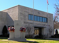
Humphreys County is a county located in the western part of Middle Tennessee, in the U.S. state of Tennessee. As of the 2020 census, the population was 18,990. Its county seat is Waverly.

<span class="mw-page-title-main">Benton County, Tennessee</span> County in Tennessee, United States

Benton County is a county located in the U.S. state of Tennessee. As of the 2020 census, the population was 15,864. Its county seat is Camden. The county was created in December 1835 and organized in 1836.

<span class="mw-page-title-main">Humphreys County, Mississippi</span> County in Mississippi, United States

Humphreys County is a county located in the U.S. state of Mississippi. As of the 2020 census, the population was 7,785. Its county seat is Belzoni. The county is named for Benjamin G. Humphreys. Humphreys County is Mississippi's newest county, having been formed in 1918. Humphreys County is located in the Mississippi Delta region.

<span class="mw-page-title-main">Arab, Alabama</span> City in Alabama, United States

Arab is a city in Marshall County in the northern part of the U.S. state of Alabama, located 10 miles (16 km) from Guntersville Lake and Guntersville Dam, and is included in the Huntsville-Decatur Combined Statistical Area. The population was 8,461 at the 2020 census.

<span class="mw-page-title-main">Tompkinsville, Kentucky</span> City in Kentucky, United States

Tompkinsville is a home rule-class city in and the county seat of Monroe County, Kentucky, United States. The population was 2,309 at the 2020 census. The city was named after Vice President Daniel D. Tompkins who served under President James Monroe, for whom the county was named.

<span class="mw-page-title-main">Big Sandy, Tennessee</span> Town in Tennessee, United States

Big Sandy is a town in Benton County, Tennessee. The population was 486 at the 2020 census.

<span class="mw-page-title-main">Camden, Tennessee</span> City in Tennessee, United States

Camden is a city in Benton County, Tennessee. The population was 3,674 at the 2020 census. It is the county seat of Benton County.

<span class="mw-page-title-main">Ashland City, Tennessee</span> Town in Tennessee, United States

Ashland City is a town and the county seat of Cheatham County, Tennessee. Located in Middle Tennessee, it is part of the Nashville-Davidson–Murfreesboro–Franklin, TN Metropolitan Statistical Area. As of the 2020 census, the town's population was 5,193.

<span class="mw-page-title-main">McEwen, Tennessee</span> City in Tennessee, United States

McEwen is a city in Humphreys County, Tennessee, United States. The population was 1,750 at the 2010 census.

<span class="mw-page-title-main">New Johnsonville, Tennessee</span> City in Tennessee, United States

New Johnsonville is a city in Humphreys County, Tennessee, United States. The population was 1,951 at the 2010 census.

<span class="mw-page-title-main">Ethridge, Tennessee</span> Town in Tennessee, United States

Ethridge is a town in Lawrence County, Tennessee, United States. The population was 465 at the 2010 census, down from 536 at the 2000 census.

<span class="mw-page-title-main">Lawrenceburg, Tennessee</span> City in Tennessee, United States

The city of Lawrenceburg is the county seat of Lawrence County, Tennessee, United States, The largest city on the state's southern border between Chattanooga and Memphis, it lies on the banks of Shoal Creek. The population was 11,633 at the 2020 United States Census. The city is named after War of 1812 American Navy officer James Lawrence.

<span class="mw-page-title-main">Loretto, Tennessee</span> City in Tennessee, United States

Loretto is a city in Lawrence County, Tennessee, United States. The population was 1,714 at the 2010 census, and 1,739 at the 2020 census.

<span class="mw-page-title-main">Saint Joseph, Tennessee</span> City in Tennessee, United States

Saint Joseph is a city in Lawrence County, Tennessee, United States. The population was 782 at the 2010 census, down from 829 in 2000.

<span class="mw-page-title-main">Athens, Tennessee</span> City in Tennessee, United States

Athens is the county seat of McMinn County, Tennessee, United States and the principal city of the Athens Micropolitan Statistical Area has a population of 53,569. The city is located almost equidistantly between the major cities of Knoxville and Chattanooga. The population was 14,084 at the 2020 census. The population of the zipcode area is at 23,726

<span class="mw-page-title-main">Lobelville, Tennessee</span> City in Tennessee, United States

Lobelville is a city in Perry County, Tennessee, United States that was established as a trading post on the Buffalo River in 1854. The population was 897 at the 2010 census.

<span class="mw-page-title-main">Cumberland City, Tennessee</span> Town in Tennessee, United States

Cumberland City is a town in Stewart County, Tennessee. The population was 311 at the 2010 census. It is part of the Clarksville, TN — Kentucky Metropolitan Statistical Area.

<span class="mw-page-title-main">Dover, Tennessee</span> City in Tennessee, United States

Dover is a city in and the county seat of Stewart County, Tennessee, 67 miles (108 km) west-northwest of Nashville on the Cumberland River. Fort Donelson National Cemetery is in Dover. The population was 1,442 at the 2000 census and the 2010 census showed a population of 1,417.

<span class="mw-page-title-main">Waynesboro, Tennessee</span> City in Tennessee, United States

Waynesboro is a city in and the county seat of Wayne County, Tennessee, United States. The population was 2,449 at the 2010 census, up from 2,228 in 2000.

References

  1. 1 2 3 4 5 "History of Humphreys County Tennessee". Humphreys County Chamber of Commerce. Archived from the original on May 16, 2007.
  2. "ArcGIS REST Services Directory". United States Census Bureau. Retrieved October 15, 2022.
  3. 1 2 "Census Population API". United States Census Bureau. Retrieved October 15, 2022.
  4. 1 2 "U.S. Census website". United States Census Bureau . Retrieved January 31, 2008.
  5. "US Board on Geographic Names". United States Geological Survey. October 25, 2007. Retrieved January 31, 2008.
  6. "Find a County". National Association of Counties. Retrieved June 7, 2011.
  7. 1 2 "Tennessee: 2010, Population and Housing Unit Counts" (PDF). United States Census Bureau. September 2012. p. 27.
  8. National Register of Historic Places; Item #73001791, Record #365523.
  9. "The Waverly Explosion". Tennessee Emergency Management Agency. 2001. Archived from the original on May 16, 2006.
  10. Ali, MD, Yasmine S. (April 2023). "Walk through fire". Trains . Kalmbach Media. pp. 14–21.
  11. "Authorities: Multiple deaths reported after flooding in Humphreys County". August 21, 2021.
  12. "Flood-related deaths in Humphreys County rises to 20; No more considered missing". August 25, 2021.
  13. "US Gazetteer files: 2010, 2000, and 1990". United States Census Bureau. February 12, 2011. Retrieved April 23, 2011.
  14. "Census of Population and Housing: Decennial Censuses". United States Census Bureau . Retrieved March 4, 2012.
  15. "Incorporated Places and Minor Civil Divisions Datasets: Subcounty Resident Population Estimates: April 1, 2010 to July 1, 2012". Population Estimates. U.S. Census Bureau. Archived from the original on June 11, 2013. Retrieved December 11, 2013.
  16. "Explore Census Data". data.census.gov. Retrieved December 27, 2021.
  17. "Susan Goodman Wins Mrs. American Pageant". Ocala Star-Banner . Vol. 39, no. 243. May 1, 1983. Retrieved December 19, 2013.

Further reading