Masilonyana Local Municipality

Last updated
Masilonyana
Masilonyana CoA.png
Map of the Free State with Masilonyana highlighted (2011).svg
Location in the Free State
Country South Africa
Province Free State
District Lejweleputswa
Seat Theunissen
Wards 10
Government
[1]
  Type Municipal council
  MayorKunatu Steve Koalane
Area
  Total6,796 km2 (2,624 sq mi)
Population
 (2011) [2]
  Total63,334
  Density9.3/km2 (24/sq mi)
Racial makeup (2011)
[2]
   Black African 91.6%
   Coloured 1.1%
   Indian/Asian 0.3%
   White 6.7%
First languages (2011)
[3]
   Sotho 66.9%
   Xhosa 10.8%
   Afrikaans 9.6%
   Tswana 6.9%
  Other5.8%
Time zone UTC+2 (SAST)
Municipal codeFS181

Masilonyana Municipality (Sotho : Masepala wa Masilonyana; Xhosa : uMasipala wase Masilonyana) is a local municipality within the Lejweleputswa District Municipality, in the Free State province of South Africa. Masilonyana is a Setswana word meaning "freedom". [4]

Contents

Main places

The 2011 census divided the municipality into the following main places: [5]

PlaceCodeArea (km2)PopulationMost spoken language
Brandfort 27.083,134 Afrikaans
Ikgomotseng 1.143,253 Tswana
Majemasweu 2.799,765 Sotho
Makeleketla 3.6912,701Sotho
Masilo 4.7021,963Sotho
Theunissen 9.151,549Afrikaans
Tshepong 0.612,042Sotho
Verkeerdevlei 7.2793Afrikaans
Winburg 63.461,373Afrikaans
Remainder of the municipality 6,676.187,461Sotho

Politics

The municipal council consists of nineteen members elected by mixed-member proportional representation. Ten councillors are elected by first-past-the-post voting in ten wards, while the remaining nine are chosen from party lists so that the total number of party representatives is proportional to the number of votes received. In the 2021 South African municipal elections the African National Congress (ANC) won a majority of eleven seats on the council.

The following table shows the results of the 2021 election. [6]

PartyWardListTotal
seats
Votes%SeatsVotes%Seats
African National Congress 6,79352.9797,28656.67211
Democratic Alliance 2,45519.1412,80121.7834
Economic Freedom Fighters 1,1719.1301,53611.9522
Independent candidates 1,42611.1200
Freedom Front Plus 7015.4706765.2611
Forum for Service Delivery 1020.8001961.5211
3 other parties1771.3803632.8200
Total12,825100.001012,858100.00919
Valid votes12,82597.5312,85897.56
Invalid/blank votes3252.473222.44
Total votes13,150100.0013,180100.00
Registered voters/turnout29,40844.7229,40844.82

Related Research Articles

<span class="mw-page-title-main">Gariep Local Municipality</span> Former local municipality in Eastern Cape, South Africa

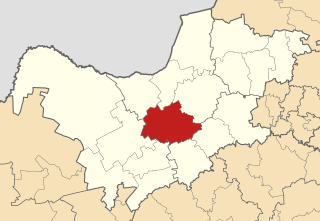
Gariep Local Municipality is a defunct local municipality in Joe Gqabi District Municipality, Eastern Cape. The municipality was merged with Maletswai Local Municipality immediately after the August 2016 Local Municipal Elections to form the new Walter Sisulu Local Municipality.

<span class="mw-page-title-main">Pixley ka Seme Local Municipality</span> Local municipality in Mpumalanga, South Africa

Pixley Ka Seme Municipality is a local municipality within the Gert Sibande District Municipality, in the Mpumalanga province of South Africa. Volksrust is the seat of the municipality.

<span class="mw-page-title-main">Maquassi Hills Local Municipality</span> Local municipality in North West, South Africa

Maquassi Hills Municipality is a local municipality within the Dr Kenneth Kaunda District Municipality, in the North West province of South Africa.

<span class="mw-page-title-main">Ratlou Local Municipality</span> Local municipality in North West, South Africa

Ratlou Municipality, formerly Setla-Kgobi Municipality, is a local municipality within the Ngaka Modiri Molema District Municipality, in the North West province of South Africa.

uMngeni Local Municipality Local municipality in KwaZulu-Natal, South Africa

uMngeni Municipality is a local municipality within the Umgungundlovu District Municipality, in the KwaZulu-Natal province of South Africa. The municipality is named after the uMngeni River that runs through the municipal area.

eMadlangeni Local Municipality Local municipality in KwaZulu-Natal, South Africa

eMadlangeni Local Municipality, previously known as Utrecht Local Municipality, is an administrative area in the Amajuba District of KwaZulu-Natal in South Africa.

uMdoni Local Municipality Area in KwaZulu-Natal, South Africa

uMdoni Municipality is a local municipality within the Ugu District Municipality, in the KwaZulu-Natal province of South Africa. uMdoni is the isiZulu name for the indigenous forest waterberry plant.

<span class="mw-page-title-main">Tswelopele Local Municipality</span> Local municipality in Free State, South Africa

Tswelopele Municipality is a local municipality within the Lejweleputswa District Municipality, in the Free State province of South Africa. Tswelopele is a Sesotho word meaning "progress".

<span class="mw-page-title-main">Elundini Local Municipality</span> Local municipality in Eastern Cape, South Africa

Elundini Municipality is a local municipality within the Joe Gqabi District Municipality, in the Eastern Cape province of South Africa. The name originates from isiZulu and refers to the Drakensberg Mountains.

<span class="mw-page-title-main">Mpofana Local Municipality</span> Local municipality in KwaZulu-Natal, South Africa

Mpofana Municipality is a local municipality within the Umgungundlovu District Municipality, in the KwaZulu-Natal province of South Africa.

<span class="mw-page-title-main">Kai ǃGarib Local Municipality</span> Local municipality in Northern Cape, South Africa

Kai ǃGarib Municipality is a local municipality within the ZF Mgcawu District Municipality, in the Northern Cape province of South Africa. The name Kai ǃGarib originates from the Khoekhoe language and means "big great river", referring to the Orange River that flows through the area.

<span class="mw-page-title-main">Mafube Local Municipality</span> Local municipality in Free State, South Africa

Mafube Municipality is a local municipality within the Fezile Dabi District Municipality, in the Free State province of South Africa. Mafube is a Sesotho word meaning "dawning of the new day".

<span class="mw-page-title-main">Great Kei Local Municipality</span> Local municipality in Eastern Cape, South Africa

Great Kei Municipality is a local municipality within the Amathole District Municipality, in the Eastern Cape province of South Africa. The word Kei is of Khoekhoe origin, meaning "sand". The municipality is named after the Great Kei River.

<span class="mw-page-title-main">Greater Kokstad Local Municipality</span> Local municipality in KwaZulu-Natal, South Africa

Greater Kokstad Municipality is a local municipality within the Harry Gwala District Municipality, in the KwaZulu-Natal province of South Africa. Kokstad is derived from Dutch, meaning "town of Kok". It was named after Adam Kok III.

<span class="mw-page-title-main">Nquthu Local Municipality</span> Local municipality in KwaZulu-Natal, South Africa

Nquthu Local Municipality is an administrative area in the Umzinyathi District of KwaZulu-Natal in South Africa. Nquthu is an isiZulu name meaning "the back of the head".

<span class="mw-page-title-main">Impendle Local Municipality</span> Local municipality in KwaZulu-Natal, South Africa

Impendle Municipality is a local municipality wirhin the Umgungundlovu District Municipality, in the KwaZulu-Natal province of South Africa. During the 18th century, the Griquas ("Abatwas") used to hide in the mountain in the area because they were accused of stealing livestock from the farmers who decided to fight the Griquas in order to protect their livestock. The Griquas used war spears, and this conflict was called "an outside war", i.e. impiyasendle or impiendle.

<span class="mw-page-title-main">Tsolwana Local Municipality</span> Former local municipality in Eastern Cape, South Africa

Tsolwana Local Municipality was an administrative area in the Chris Hani District of the Eastern Cape in South Africa. Tsolwana is an isiXhosa name which means "something with a sharp ending or a tip", referring the mountains around the whole area. After municipal elections on 3 August 2016 it was merged into the larger Enoch Mgijima Local Municipality.

<span class="mw-page-title-main">Mthonjaneni Local Municipality</span> Local municipality in KwaZulu-Natal, South Africa

Mthonjaneni is an administrative area in the King Cetshwayo District of KwaZulu-Natal in South Africa.

<span class="mw-page-title-main">Nketoana Local Municipality</span> Local municipality in Free State, South Africa

Nketoana Municipality is a local municipality within the Thabo Mofutsanyane District Municipality, in the Free State province of South Africa.

<span class="mw-page-title-main">Umvoti Local Municipality</span> Local municipality in KwaZulu-Natal, South Africa

Umvoti Local Municipality is an administrative area in the Umzinyathi District of KwaZulu-Natal in South Africa.

References

  1. "Contact list: Executive Mayors". Government Communication & Information System. Archived from the original on 14 July 2010. Retrieved 22 February 2012.
  2. 1 2 "Statistics by place". Statistics South Africa. Retrieved 27 September 2015.
  3. "Statistics by place". Statistics South Africa. Retrieved 27 September 2015.
  4. South African Languages - Place names
  5. "Census 2011: Local Municipality: Masilonyana".
  6. "Election Result Table for LGE2021 — Masilonyana". wikitable.frith.dev. Retrieved 2021-11-20.

28°31′00″S27°01′00″E / 28.5167°S 27.0167°E / -28.5167; 27.0167