Lemmon Valley is a census-designated place (CDP) in Washoe County, Nevada, United States. The population was 5,040 at the 2010 census. It is a northern suburb of the city of Reno and is part of the Reno–Sparks Metropolitan Statistical Area. Prior to 2010 it was listed by the U.S. Census Bureau as part of the Lemmon Valley–Golden Valley CDP.
The Virginia Range is a mountain range of western Nevada, primarily within Storey County, and extending east into Lyon County. The range is named after James Finney, "Old Virginny", an early discoverer of gold associated with the Comstock Lode.

Pleasant Valley is a very small, unincorporated community in Washoe County, Nevada, United States. The ZIP Code for Pleasant Valley is 89511. The community is part of the Reno–Sparks Metropolitan Statistical Area and Interstate 580, U.S. Route 395 and U.S. Route 395 Alternate run through it and act as a divider between the eastern and western halves of the valley.
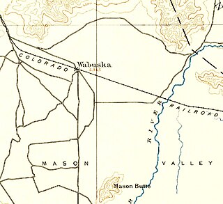
Wabuska is an unincorporated community in Lyon County, Nevada, United States. The zip code is 89447, which it shares with nearby Yerington.
KBUL-FM is a commercial radio station located in Reno, Nevada, broadcasting to the Western Nevada and Lake Tahoe areas on 98.1 FM. KBUL-FM airs a country music format and is under ownership of Cumulus Media. In October 16, 2015 the K Bull name was changed to Nash FM but still same frequency and format.

Little Yosemite Valley is a smaller glacial valley upstream in the Merced River drainage from the Yosemite Valley in Yosemite National Park. The Merced River meanders through the 3.5 mi (5.6 km) long flat valley, draining out over Nevada Fall and Vernal Fall before emptying into the main Yosemite Valley. It can be reached by a day hike from the main valley, and is the most popular area in the Yosemite Wilderness. The Valley provides access to nearby destinations such as the back side of Half Dome, Clouds Rest and the High Sierra Camp at Merced Lake.
Emigrant Pass may refer to:
Mogul is a census-designated place (CDP) in Washoe County, Nevada, United States. It lies on the western side of the Reno–Sparks Metropolitan Statistical Area, just off Interstate 80. The population was 1,290 at the 2010 census. Prior to 2010, the community was part of the Verdi-Mogul CDP.

The Salinian Block or Salinian terrane is a geologic terrane which lies west of the main trace of the San Andreas Fault system in California. It is bounded on the south by the Big Pine Fault in Ventura County and on the west by the Nacimiento Fault. It was named for the Salinas Valley in Monterey County, California.
Golden Valley is a census-designated place (CDP) in Washoe County, Nevada, United States. The population was 1,556 at the 2010 census. It is a northern suburb of the city of Reno and is part of the Reno–Sparks Metropolitan Statistical Area. Prior to 2010, it was listed by the U.S. Census Bureau as part of the Lemmon Valley–Golden Valley CDP.

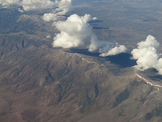
The Washoe Valley is a geographical region in the United States covering 66 square miles (170 km2) in southern Washoe County in the state of Nevada. Located between Reno and Carson City, it is named for the Washoe people, Native Americans who lived there before the arrival of Europeans. Slide Mountain and Mount Rose overlook the valley from the west.

The Pyramid Lake Fault Zone is an active right lateral-moving (dextral) geologic fault located in western Nevada. It is considered an integral part of the Walker Lane.

The Phoenixville Tunnel, originally called the Fairview Tunnel, was part of the Pennsylvania Schuylkill Valley Railroad in Phoenixville, Pennsylvania.
The Spearhead 2,457 m (8,061 ft) is a peak in the Garibaldi Ranges of British Columbia, Canada, and is one of the main summits of the Blackcomb Mountain portion of the Whistler Blackcomb ski resort, located at the apex of the Blackcomb and Spearhead Glaciers, which is named for it. It also is the namesake of the Spearhead Range, which is the short range flanking the north side of Fitzsimmons Creek and ending on its northwest end at Blackcomb Mountain.

The Reno Air Defense Sector (ReADS) is an inactive United States Air Force organization. Its last assignment was with the 28th Air Division, being stationed at Stead Air Force Base, Nevada.
The Yerington Paiute Tribe of the Yerington Colony and Campbell Ranch is a federally recognized tribe of Northern Paiute Indians in western Nevada.
Patrick is an unincorporated community in Storey County which was the site of a historic ranch. The founder of the ranch, Patrick McCarran, arrived in Nevada in 1858 as a member of the United States Army under General Winfield Scott Hancock. In 1862 McCarran claimed 2,600 acres (1,100 ha) of land that would become McCarran Ranch and the unincorporated community of Patrick. Patrick's son, Pat McCarran, became Nevada's first native born U.S. Senator and a staunch anti communist. Patrick Nevada is also the owner of four of the cattle in the ranch.
Hualapai Flat is a valley in northwestern Nevada, USA, located northwest of the Black Rock Desert. The two valleys are separated by the Calico Hills. The Granite Range marks the southern and western edges of Hualapai Flat. To the north the valley is constrained by the Granite Range and the Calico Hills. Washoe, Pershing, and Humboldt counties meet in the Hualapai Flat.

Washoe Valley is a census-designated place (CDP) in Washoe County, Nevada, United States. It corresponds closely to the unincorporated community of New Washoe City. The population was 3,019 at the 2010 census. It is part of the Reno–Sparks Metropolitan Statistical Area. The CDP takes its name from the Washoe Valley, a region between Reno and Carson City centered on Washoe Lake.