Vanuatu, officially the Republic of Vanuatu, is an island country in Melanesia, located in the South Pacific Ocean. The archipelago, which is of volcanic origin, is 1,750 km (1,090 mi) east of northern Australia, 540 km (340 mi) northeast of New Caledonia, east of New Guinea, southeast of Solomon Islands, and west of Fiji.
Shefa is one of the six provinces of Vanuatu, located in the center of the country and including the islands of Epi and Efate and the Shepherd Islands. The province's name is derived from the initial letters of SHepherd and EFAte. It has a population of 78,723 people and an area of 1,455 km2. Its capital is Port Vila, which is also the capital of the nation.

Malo is an island in Vanuatu 3 km (1.9 mi) off the southern coast of Vanuatu's largest island, Espiritu Santo, in Sanma Province. It has a circumference of 55 km (34 mi) and an area of 180 km2 (69 sq mi). It is 17 kilometres or 11 miles long, and 13 kilometres or 8.1 miles across at its widest point. The highest point on the island is Mount Malo.
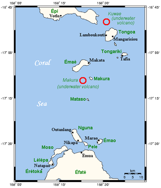
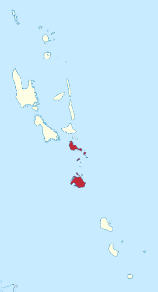
The Shepherd Islands are a group of islands lying between the larger islands of Epi and Éfaté, in the Shefa province of Vanuatu. The aggregate land area is 88 square kilometres. They were named by Captain Cook after Anthony Shepherd, a British astronomer and friend of Cook.

Emae is an island in the Shepherd Islands, Shefa, Vanuatu.

North Efate, also known as Nakanamanga or Nguna, is an Oceanic language spoken on the northern area of Efate in Vanuatu, as well as on a number of islands off the northern coast – including Nguna, and parts of Tongoa, Emae and Epi.

Rah or Ra is a small coral islet of 0.5 km2 (0.19 sq mi), located in the Banks group of northern Vanuatu. The same name also refers to the single village which is situated within this islet.
Emae, Emwae or Mae language, is a Polynesian outlier language of Vanuatu.
Ngwel is an uninhabited island in Torba Province of Vanuatu in the Pacific Ocean. The island is a part of the Torres Islands archipelago.
Malokilikili Island is an inhabited island in Sanma Province of Vanuatu in the Pacific Ocean. Malokilikili lies off the eastern coast of Malo Island.

Ifira is an offshore island of Efate, located in Shefa Province of Vanuatu in the Pacific Ocean.

Emao is a small inhabited island in Shefa Province of Vanuatu in the Pacific Ocean. It was also previously known as Montague Island.

Makura, locally known as Makira, is a small, inhabited island in Shefa Province of Vanuatu in the Pacific Ocean. Makura is a part of the Shepherd Islands archipelago.
Tongoa is an inhabited island in Shefa Province of Vanuatu in the Pacific Ocean.
Buninga Island is an inhabited island in Shefa Province of Vanuatu in the Pacific Ocean. The island is a part of Shepherd Islands archipelago.
Tongariki Island is an inhabited island in Shefa Province of Vanuatu in the Pacific Ocean. The island is a part of Shepherd Islands archipelago.

Lamen is an inhabited island in Shefa Province of Vanuatu in the Pacific Ocean. The island is a part of Shepherd Islands archipelago.
Ewose is a small uninhabited island in the Shefa Province of Vanuatu in the Pacific Ocean.
Wot Rock is a small uninhabited islet in the Pacific Ocean, a part of the Shepherd Islands archipelago in the Shefa Province of Vanuatu. Wot is located close to Emae Island.
Malparavu is a small uninhabited island in Sanma Province of Vanuatu in the Pacific Ocean.


