Maxwell, California

Last updated
Maxwell
USA California location map.svg
Red pog.svg
Maxwell
Location in California
Coordinates: 39°16′35″N122°11′29″W / 39.27639°N 122.19139°W / 39.27639; -122.19139 Coordinates: 39°16′35″N122°11′29″W / 39.27639°N 122.19139°W / 39.27639; -122.19139
Country United States
State California
County Colusa County
Area
[1]
  Total2.150 sq mi (5.569 km2)
  Land2.150 sq mi (5.569 km2)
  Water0 sq mi (0 km2)  0%
Elevation
[2]
92 ft (28 m)
Population
 (2010)
  Total1,103
  Density510/sq mi (200/km2)
Time zone UTC-8 (Pacific (PST))
  Summer (DST) UTC-7 (PDT)
ZIP Code
95955
Area code(s) 530
GNIS feature IDs 228245, 2583074

Maxwell (formerly, Occident) is a census-designated place [3] and farm community in Colusa County, California. It lies at an elevation of 92 feet (28 m). Located off Interstate 5, it is home to Maxwell High School. The main crop grown is rice, though a variety of others such as grapes, almonds, olives, squash, and sunflowers are grown as well. Its ZIP code is 95955 and its area code is 530. Maxwell's population was 1,103 at the 2010 census.

Contents

History

The community bears the name of its founder. [4] Swifts Stone Corral is listed as a California Historical Landmark No. 238. The original owner and builder of this stone corral was Granville P. Swift, a native of Kentucky. In 1847 Swift began ranching in Stone Creek Valley in Colusa County. In 1850 he and his partner Frank Sears needed a corral and, as there was no timber in the surrounding country, they built one from the flat stones that were scattered over the area. [5]

Demographics

The 2010 United States Census [6] reported that Maxwell had a population of 1,103. The population density was 512.9 inhabitants per square mile (198.0/km2). The racial makeup of Maxwell was 734 (43.9%) White, 11 (0.7%) African American, 14 (0.8%) Native American, 9 (0.5%) Asian, 2 (0.1%) Pacific Islander, 306 (18.3%) from other races, and 27 (1.6%) from two or more races. Hispanic or Latino of any race were 570 persons (34.1%).

The Census reported that 1,103 people (100% of the population) lived in households, 0 (0%) lived in non-institutionalized group quarters, and 0 (0%) were institutionalized.

There were 365 households, out of which 156 (42.7%) had children under the age of 18 living in them, 208 (57.0%) were opposite-sex married couples living together, 43 (11.8%) had a female householder with no husband present, 24 (6.6%) had a male householder with no wife present. There were 12 (3.3%) unmarried opposite-sex partnerships, and 5 (1.4%) same-sex married couples or partnerships. 79 households (21.6%) were made up of individuals, and 38 (10.4%) had someone living alone who was 65 years of age or older. The average household size was 3.02. There were 275 families (75.3% of all households); the average family size was 3.56.

The population was spread out, with 356 people (32.3%) under the age of 18, 89 people (8.1%) aged 18 to 24, 265 people (24.0%) aged 25 to 44, 242 people (21.9%) aged 45 to 64, and 151 people (13.7%) who were 65 years of age or older. The median age was 33.9 years. For every 100 females, there were 108.9 males. For every 100 females age 18 and over, there were 101.9 males.

There were 408 housing units at an average density of 189.7 per square mile (73.2/km2), of which 365 were occupied, of which 235 (64.4%) were owner-occupied, and 130 (35.6%) were occupied by renters. The homeowner vacancy rate was 0.4%; the rental vacancy rate was 1.5%. 695 people (63.0% of the population) lived in owner-occupied housing units and 408 people (37.0%) lived in rental housing units.

Politics

In the state legislature, Maxwell is in the 4th Senate District , represented by Republican Jim Nielsen, [7] and the 3rd Assembly District , represented by Republican James Gallagher. [8] Federally, Maxwell is in California's 3rd congressional district , represented by Democrat John Garamendi. [9]

Related Research Articles

Arbuckle, California Census-designated place in California, United States

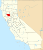
Arbuckle is a census-designated place (CDP) in Colusa County, California, United States. The population was 3,028 at the 2010 census, up from 2,332 at the 2000 census. Arbuckle is situated in the southerly portion of Colusa County, approximately 20 miles (32 km) southwest of the City of Colusa, the county seat. The town is characterized by single-family residences, multiple-family units, some mobile homes, and commercial activities. Land surrounding Arbuckle is agriculture including cultivated annual crops, and both active and unmaintained orchards. Various almond hullers may be found near the area. Regional access is provided by the north-south running Interstate 5, along with Old Highway 99 West running alongside Interstate 5.

Colusa, California City in California, United States

Colusa is a city in and the county seat of Colusa County, California. The population was 5,971 at the 2010 census, up from 5,402 at the 2000 census. Colusi originates from the local Coru Native American tribe, who in the 1840s lived on the opposite side of the Sacramento River.

China Lake Acres, California Census-designated place in California, United States

China Lake Acres is a census-designated place (CDP) in Kern County, California, United States. The population was 1,876 at the 2010 census, up from 1,761 at the 2000 census.

Coulterville, California Census-designated place in California, United States

Coulterville is a census-designated place in Mariposa County, California, United States. It is located on Maxwell Creek 20 miles (32 km) northwest of Mariposa, at an elevation of 1,699 feet (518 m). Coulterville had a population of 115 at the 2020 census, down from 201 at the 2010 census, when the CDP covered a much greater area. It is a mining town located in the foothills of the Sierra Nevada. The ZIP Code is 95311. The community is inside area code 209.

Warm Springs is a census-designated place in Riverside County, California. Warm Springs sits at an elevation of 1,365 feet (416 m). The 2010 United States census reported Warm Springs's population was 2,676.

Janesville, California Census-designated place in California, United States

Janesville is a census-designated place in Lassen County, California. It is located 11 miles (18 km) southeast of Susanville, at an elevation of 4239 feet. Janesville is located on the eastern slopes of the Sierra Nevada Mountain range. Its population is 2,461 as of the 2020 census, up from 1,408 from the 2010 census.

Rio Oso is a census-designated place (CDP) in Sutter County, California. Rio Oso sits at an elevation of 52 feet (16 m). The ZIP Code is 95674. The community is inside area code 530. The 2010 United States census reported Rio Oso's population was 356.

Princeton is a census-designated place in Colusa County, California. It lies at an elevation of 82 feet. Its ZIP code is 95970 and its area code is 530. Princeton's population was 303 at the 2010 census.

Grimes is a census-designated place in Colusa County, California on the Southern Pacific Railroad. It lies at an elevation of 46 feet. The two main roads that run through it are State Route 45 and Grimes-Arbuckle Road. Its ZIP code is 95950, and its area code is 530. Grimes's population was 391 at the 2020 census.

College City is a census-designated place in Colusa County, California. It lies at an elevation of 72 feet (22 m) above sea level. Its ZIP code is 95912, and its area code is 530. Its population was 290 at the 2010 census.

Buckhorn is a census-designated place in Amador County, California. Buckhorn sits at an elevation of 3,238 feet. The community is in ZIP code 95666 and area code 209. The 2010 United States census reported Buckhorn's population was 2,429.

North San Juan, California Census-designated place in California, United States

North San Juan is a census-designated place in Nevada County, California, United States, along State Route 49 on the San Juan Ridge in Gold Country. The zip code is 95960. The population was 269 at the 2010 census.

Lodoga is a census-designated place in Colusa County, California. It lies at an elevation of 1237 feet. Lodoga's population was 197 at the 2010 census.

Indianola, California Census-designated place in California, United States

Indianola is a census-designated place in Humboldt County, California. It is located 4 miles (6.4 km) south of Arcata, at an elevation of 46 feet. The place appears on the USGS Arcata South map. Addresses in this neighborhood are part of unincorporated Eureka, California, located entirely within the 95503 ZIP code. The population was 823 at the 2010 census.

Clearlake Riviera, California Census-designated place in California, United States

Clearlake Riviera is a census-designated place in Lake County, California. It lies at an elevation of 1755 feet. The population was 3,090 at the 2010 census.

Litchfield, California Census-designated place in California, United States

Litchfield is a census-designated place in Lassen County, California. It is located 15 miles (24 km) east of Susanville, at an elevation of 4,065 feet (1,239 m). Its population is 160 as of the 2020 census, down from 195 from the 2010 census.

Patton Village is a census-designated place in Lassen County, California. It lies at an elevation of 4111 feet. Its population is 632 as of the 2020 census, down from 702 from the 2010 census.

Red Corral is a census-designated place in Amador County, California. Red Corral sits at an elevation of 2710 feet. The 2010 United States census reported Red Corral's population was 1,413.

Lemon Hill, California Census-designated place in California, United States

Lemon Hill is a census-designated place in an unincorporated area of Sacramento County, California, south of the city of Sacramento. Lemon Hill sits at an elevation of 30 feet (9.1 m). The 2010 United States census reported Lemon Hill's population was 13,729.

Pine Flat is a census-designated place (CDP) in Tulare County, California. Pine Flat sits at an elevation of 3,871 feet (1,180 m). The 2010 United States census reported Pine Flat's population was 166.

References

  1. "2010 Census U.S. Gazetteer Files – Places – California". United States Census Bureau.
  2. "Maxwell". Geographic Names Information System . United States Geological Survey.
  3. U.S. Geological Survey Geographic Names Information System: Maxwell, California
  4. Gannett, Henry (1905). The Origin of Certain Place Names in the United States. U.S. Government Printing Office. p.  203.
  5. "Swift's Stone Corral".
  6. "2010 Census Interactive Population Search: CA - Maxwell CDP". U.S. Census Bureau. Archived from the original on July 15, 2014. Retrieved July 12, 2014.
  7. "Senators". State of California. Retrieved March 21, 2013.
  8. "Members Assembly". State of California. Retrieved March 21, 2013.
  9. "California's 3rd Congressional District - Representatives & District Map". Civic Impulse, LLC. Retrieved March 1, 2013.