Mayodan, North Carolina

Last updated

Mayodan, North Carolina
Mayodan, North Carolina.jpg
NCMap-doton-Mayodan.PNG
Location of Mayodan, North Carolina
Coordinates: 36°25′16″N79°58′03″W / 36.42111°N 79.96750°W / 36.42111; -79.96750
Country United States
State North Carolina
County Rockingham
Named for The confluence of the Dan and Mayo rivers
Government
  MayorChad Wall [ citation needed ]
  Town ManagerKathleen Patterson [ citation needed ]
Area
[1]
  Total2.90 sq mi (7.51 km2)
  Land2.88 sq mi (7.45 km2)
  Water0.02 sq mi (0.05 km2)
Elevation
[2]
656 ft (200 m)
Population
 (2020)
  Total2,418
  Density840.46/sq mi (324.53/km2)
Time zone UTC-5 (Eastern (EST))
  Summer (DST) UTC-4 (EDT)
ZIP code
27027
Area code 336
FIPS code 37-42060 [3]
GNIS feature ID2406116 [2]
Website www.townofmayodan.com
The Pannill family on the porch of their home, Mayodan, 1911 Pannill family Mayodan.jpg
The Pannill family on the porch of their home, Mayodan, 1911

Mayodan is a town in Rockingham County, North Carolina, in the United States. It is a manufacturing site for Sturm, Ruger & Co., Bridgestone Aircraft Tire, and formerly General Tobacco (ceased operations 2010). Washington Mills Company, later Tultex, operated a textile mill in Mayodan until 1999. [4]

Contents

The town is named for two rivers that converge nearby, the Mayo and the Dan, and, according to Ripley's Believe It or Not! , is the only town in the world with this name. [5]

History

Mayodan started as a mill town when a cotton mill was built in 1892. Operations began in April 1896. [5] The Washington Mills-Mayodan Plant was listed on the National Register of Historic Places in 2005. [6]

Geography

According to the United States Census Bureau, the town has a total area of 1.5 square miles (3.9 km2); 1.5 square miles (3.9 km2) of the area is land and 0.66% is water.

Mayodan is located near the confluence of the Mayo and Dan Rivers.

Schools

Demographics

Historical population
CensusPop.Note
1900 904
1910 874−3.3%
1920 1,886115.8%
1930 1,9483.3%
1940 2,32319.3%
1950 2,246−3.3%
1960 2,3665.3%
1970 2,87521.5%
1980 2,627−8.6%
1990 2,471−5.9%
2000 2,417−2.2%
2010 2,4782.5%
2020 2,411−2.7%
2021 (est.)2,415 [7] 0.2%
U.S. Decennial Census [8] [9]

2020 census

Mayodan racial composition [10]
RaceNumberPercentage
White (non-Hispanic)1,88778.04%
Black or African American (non-Hispanic)28411.75%
Native American 30.12%
Asian 100.41%
Other/Mixed 1054.34%
Hispanic or Latino 1295.33%

As of the 2020 United States census, there were 2,418 people, 1,170 households, and 671 families residing in the town.

2010 census

As of the census [3] of 2010, there were 2,478 people, 1,173 households, and 651 families residing in the town. The population density was 1,608.8 inhabitants per square mile (621.2/km2). There were 1,268 housing units at an average density of 844.0 per square mile (325.9/km2). The racial makeup of the town was 85.85% White, 10.38% African American, 0.17% Native American, 0.21% Asian, 2.57% from other races, and 0.83% from two or more races. Hispanic or Latino of any race were 4.01% of the population.

There were 1,173 households, out of which 21.4% had children under the age of 18 living with them; 38.6% were married couples living together; 13.3% had a female householder with no husband present; and 44.5% were non-families. 41.4% of all households were made up of individuals, and 21.2% had someone living alone who was 65 years of age or older. The average household size was 2.06 and the average family size was 2.78 people.

The population's age distribution was broad: 19.3% under the age of 18, 7.4% from 18 to 24, 27.5% from 25 to 44, 23.4% from 45 to 64, and 22.4% who were 65 years of age or older. The median age was 43 years. For every 100 females, there were 82.3 males. For every 100 females age 18 and over, there were 79.7 males.

The median income for a household in Mayodan was $25,980, and the median income for a family was $36,328. Males had a median income of $25,878 versus $21,250 for females. The per capita income for the town was $15,607. 16.0% of the population and 11.3% of families were below the poverty line. 20.5% of those under the age of 18 and 17.9% of those 65 and older were living below the poverty line.

Notable resident

(1995-Current)-- Backyard/Death Match Wrestler Ring Name: "Natural" Frankie Watson

Related Research Articles

<span class="mw-page-title-main">Oxford, Kansas</span> City in Sumner County, Kansas

Oxford is a city in Sumner County, Kansas, United States. As of the 2020 census, the population of the city was 1,048.

Bradley is a town in Penobscot County, Maine, United States. It is part of the Bangor Metropolitan Statistical Area. The population was 1,532 at the 2020 census. The village of Bradley is in the northwestern corner of the town.

<span class="mw-page-title-main">East Kingston, New Hampshire</span> Place in New Hampshire, United States

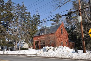
East Kingston is a town in Rockingham County, New Hampshire, United States. The population was 2,441 at the 2020 census.

<span class="mw-page-title-main">Kensington, New Hampshire</span> Place in New Hampshire, United States

Kensington is a town in Rockingham County, New Hampshire, United States. The population was 2,095 at the 2020 census.

<span class="mw-page-title-main">Seabrook, New Hampshire</span> Town in New Hampshire, United States

Seabrook is a town in Rockingham County, New Hampshire, United States. The population was 8,401 at the 2020 census. Located at the southern end of the coast of New Hampshire, on the border with Massachusetts, Seabrook is noted as the location of the Seabrook Station Nuclear Power Plant, the third-most recently constructed nuclear power plant in the United States.

<span class="mw-page-title-main">Oak Ridge, North Carolina</span> Town in North Carolina, United States

Oak Ridge is a town in northwestern Guilford County, North Carolina, United States. As of the census of 2020, the town had a population of 7,474. Oak Ridge is 15 miles (24 km) northwest of the center of Greensboro, North Carolina's third-most populous city. Oak Ridge is a part of the Piedmont Triad urban area.

<span class="mw-page-title-main">Stokesdale, North Carolina</span> Town in North Carolina, United States

Stokesdale is a town in Guilford County, North Carolina, United States with small parts in the counties of Rockingham, Forsyth, and Stokes. The population was 5,924 at the 2020 census. Belews Lake is located nearby, and North Carolina Highway 68 and North Carolina Highway 65 both intersect U.S. Route 158 near the town's center.

<span class="mw-page-title-main">Madison, North Carolina</span> Town in North Carolina, United States

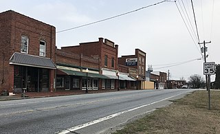
Madison is a town located in Rockingham County, North Carolina. At the 2020 census, the town had a total population of 2,132. Madison is part of the Greensboro-High Point Metropolitan Statistical Area of the Piedmont Triad metro region. It was home to the corporate headquarters of Remington Arms until 2020, when the company was made defunct by bankruptcy proceedings. It is still home to Marlin Firearms, which was an asset of Remington now owned by Sturm, Ruger & Co.

<span class="mw-page-title-main">Stoneville, North Carolina</span> Town in North Carolina, United States

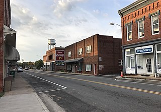
Stoneville is a town in Rockingham County, North Carolina, United States. Stoneville is part of the Greensboro–High Point metropolitan area of the Piedmont Triad. At the 2020 United States census, the town had a population of 1,308.

<span class="mw-page-title-main">Walnut Cove, North Carolina</span> Town in North Carolina, United States

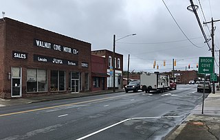
Walnut Cove is a town in Stokes County, North Carolina, United States. The population was 1,536 at the 2020 census.

<span class="mw-page-title-main">New Boston, Ohio</span> Village in Ohio, United States

New Boston is a village in Scioto County, Ohio, United States, along the Ohio River. The population was 2,298 at the 2020 census. Apart from its southern boundary on the Ohio River, New Boston is entirely surrounded by the city of Portsmouth.

<span class="mw-page-title-main">Curtisville, Pennsylvania</span> Census-designated place in Pennsylvania, United States

Curtisville is a census-designated place (CDP) in West Deer Township, Pennsylvania, United States. The population was 1,097 at the 2020 census.

<span class="mw-page-title-main">South Huntingdon Township, Pennsylvania</span> Township in Pennsylvania, United States

South Huntingdon Township is a township in Westmoreland County, Pennsylvania, United States. The population was 5,412 at the 2020 census.

<span class="mw-page-title-main">Elwood, Utah</span> Town in the state of Utah, United States

Elwood is a town in Box Elder County, Utah, United States. The population was 1,173 at the 2020 census, up from the 2010 figure of 1,034.

<span class="mw-page-title-main">Mount Crawford, Virginia</span> Town in Virginia, United States

Mount Crawford is a town in Rockingham County, Virginia, United States. It is included in the Harrisonburg Metropolitan Statistical Area, and the town's population was 433 at the 2010 census.

<span class="mw-page-title-main">Bruceton Mills, West Virginia</span> Town in West Virginia, United States

Bruceton Mills is a town in northern Preston County, West Virginia, United States, along Big Sandy Creek. The population was 64 at the 2020 census, making it the second-least populous town in West Virginia, after Thurmond. It is part of the Morgantown metropolitan area.

<span class="mw-page-title-main">Harman, West Virginia</span> Town in West Virginia, United States

Harman is a town in Randolph County, West Virginia, United States. The population was 96 at the 2020 census.

<span class="mw-page-title-main">Mill Creek, West Virginia</span> Town in West Virginia, United States

Mill Creek is a town in Randolph County, West Virginia, United States, along the Tygart Valley River. The population was 563 at the 2020 census.

<span class="mw-page-title-main">Grottoes, Virginia</span> Town in Virginia, United States

Grottoes is an incorporated town in Augusta and Rockingham counties in the U.S. state of Virginia. The population was 2,668 at the 2010 census.

Norway is a census-designated place (CDP) in the town of Norway in Oxford County, Maine, United States. The population was 2,623 at the 2000 census.

References

  1. "ArcGIS REST Services Directory". United States Census Bureau. Retrieved September 20, 2022.
  2. 1 2 U.S. Geological Survey Geographic Names Information System: Mayodan, North Carolina
  3. 1 2 "U.S. Census website". United States Census Bureau . Retrieved January 31, 2008.
  4. "Washington Mills Collection". James Library, Rockingham Community College. Retrieved May 8, 2010.
  5. 1 2 MAYODAN, NC. Western Rockingham Chamber of Commerce. Retrieved May 14, 2016.
  6. "National Register Information System". National Register of Historic Places . National Park Service. July 9, 2010.
  7. "City and Town Population Totals: 2020-2021". Census.gov. US Census Bureau. Retrieved July 9, 2022.
  8. "Census of Population and Housing". Census.gov. Retrieved June 4, 2015.
  9. "Census of Population and Housing". Census.gov. Retrieved June 4, 2016.
  10. "Explore Census Data". data.census.gov. Retrieved December 21, 2021.