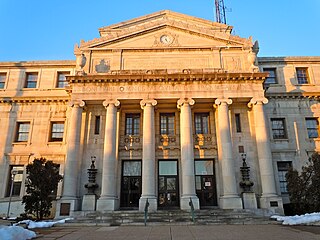
Oneida County is a county in the state of New York, United States. As of February 26, 2024, the population was 226,654. The county seat is Utica. The name is in honor of the Oneida, one of the Five Nations of the Iroquois League or Haudenosaunee, which had long occupied this territory at the time of European encounter and colonization. The federally recognized Oneida Indian Nation has had a reservation in the region since the late 18th century, after the American Revolutionary War.

Montgomery County is a county located in the Valley and Ridge area of the U.S. state of Virginia. As population in the area increased, Montgomery County was formed in 1777 from Fincastle County, which in turn had been taken from Botetourt County. As of the 2020 census, the population was 99,721. Its county seat is Christiansburg, and Blacksburg is the largest town. Montgomery County is part of the Blacksburg-Christiansburg metropolitan area. It is dominated economically by the presence of Virginia Tech, Virginia's third largest public university, which is the county's largest employer.

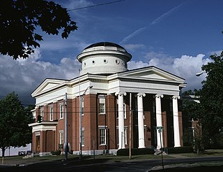
Montgomery County is a county located in the U.S. state of Alabama. As of the 2020 census, its population was 228,954, making it the seventh-most populous county in Alabama. Its county seat is Montgomery, the state capital. Montgomery County is included in the Montgomery Metropolitan Statistical Area.
Delaware County, colloquially referred to as Delco, is a county in the Commonwealth of Pennsylvania. With a population of 576,830 as of the 2020 census, it is the fifth-most populous county in Pennsylvania and the third-smallest in area. The county was created on September 26, 1789, from part of Chester County and named for the Delaware River. The county is part of the Southeast Pennsylvania region of the state.

Potomac is an unincorporated community and census-designated place in Montgomery County, Maryland, United States. As of the 2020 census, it had a population of 47,018. It is named after the nearby Potomac River. A part of the Washington metropolitan area, many Potomac residents work in nearby Washington, D.C., and Northern Virginia.

Christiansburg is a town in Montgomery County, Virginia, United States. The population was 23,348 at the 2020 census, up from 21,041 at the 2010 census. It is the county seat of Montgomery County. Christiansburg, Blacksburg and the city of Radford are the three principal municipalities of the Blacksburg–Christiansburg Metropolitan Statistical Area, which encompasses those municipalities, all of Montgomery County, and three other counties.

Germantown is an urbanized census-designated place in Montgomery County, Maryland. With a population of 91,249 as of the 2020 census, it is the third most populous place in Maryland, after Baltimore and Columbia. Germantown is located approximately 28 miles (45 km) outside the U.S. capital of Washington, D.C., and is an important part of the Washington metropolitan area.

Mississippi Mills is a town in eastern Ontario, Canada, in Lanark County on the Mississippi River. It is made up of the former Townships of Ramsay and Pakenham, as well as the Town of Almonte. It is partly located within Canada's National Capital Region.
Delray is an unincorporated community in Hampshire County in the U.S. state of West Virginia. Delray is located in the North River Valley along Delray Road between Sedan and Rio. According to the 2000 census, the Delray community has a population of 151.
Prices Fork is a small traditionally agricultural census-designated place (CDP), in Montgomery County, Virginia, United States. The population as of the 2010 Census was 1,066. It is located about three miles west of Blacksburg and the campus of Virginia Polytechnic Institute and State University.
The 61st Georgia Infantry Regiment was an infantry regiment in the Confederate States Army during the American Civil War.
The Panhandle Trail is a rail trail in southern Pennsylvania and the Northern Panhandle of West Virginia. It occupies an abandoned railroad corridor that had been known as the Panhandle route which has been converted to a bicycle and walking trail. The rail line between Burgettstown and Weirton was closed in 1994, but Burgettstown to Walkers Mill closed in 1996. The original section of the trail is the West Virginia section, where the trail was called the Harmon Creek Trail, for the adjacent Harmon Creek. When Pennsylvania built its section, both states agreed to call it the Panhandle Trail. Although the Panhandle Trail occupies 29 miles of the Panhandle Route, the remaining portion of the route is owned by the Pittsburgh and Ohio Central Railroad, but it is no longer used.

Norval is an unincorporated community in the town of Halton Hills, Ontario, Canada, within the Regional Municipality of Halton. Situated on the Credit River at the intersection of Highway 7 and Winston Churchill Boulevard, it is located immediately east of Georgetown and approximately 3 km (1.9 mi) west of the current urban boundary of Brampton.
Hook's Tavern or Hook Tavern was a late 18th-century tavern along the Northwestern Turnpike east of Capon Bridge in Hampshire County, West Virginia. It was listed on the National Register of Historic Places on April 29, 2011. It burned in an alleged arson on October 14, 2022.
Hope Hull, also known as McGehee's Switch, is an unincorporated community in Montgomery County, Alabama, United States, southwest of Montgomery.
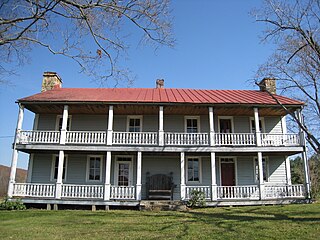
Bennetts Mill is an unincorporated community in Montgomery County, Virginia, in the United States.
Smithsonia, also known as Cave Springs, is an unincorporated community in Lauderdale County, in the U.S. state of Alabama.
Wright, also known as Wrights Cross Roads, is an unincorporated community in Lauderdale County, in the U.S. state of Alabama.

Newport Mill Middle School is a public school for students in grades 6, 7, and 8, located in Kensington, Maryland.
Garland is an unincorporated community in Butler County, Alabama, United States, located 6 miles (9.7 km) west of McKenzie.


