
James City County is a county located in the Commonwealth of Virginia. As of the 2020 census, the population was 78,254. Although politically separate from the county, the county seat is the adjacent independent city of Williamsburg.

Bristol is an independent city in the Commonwealth of Virginia. As of the 2020 census, the population was 17,219. It is the twin city of Bristol, Tennessee, just across the state line, which runs down the middle of its main street, State Street. It is surrounded on three sides by Washington County, Virginia, which is combined with the city for statistical purposes. It is a principal city in the Kingsport–Bristol metropolitan area, which had a population of 307,614 in 2020. The metro area is a component of the larger Tri-Cities region of Tennessee and Virginia, with a population of 508,260 in 2020.

Kane County is a county in the U.S. state of Illinois. According to the 2020 census, it has a population of 516,522, making it the fifth-most populous county in Illinois. Its county seat is Geneva, and its largest city is Aurora. Kane County is one of the collar counties of the metropolitan statistical area designated "Chicago–Naperville–Elgin, IL–IN–WI" by the US census.

Springfield is a census-designated place (CDP) in Fairfax County, Virginia, United States. The Springfield CDP is recognized by the U.S. Census Bureau with a population of 31,339 as of the 2020 census. Previously, per the 2010 census, the population was 30,484. Homes and businesses in bordering CDPs including North Springfield, West Springfield, and Newington are usually given a Springfield mailing address. The population of the collective areas with Springfield addresses is estimated to exceed 100,000. The CDP is a part of Northern Virginia, the most populous region of the Washington Metropolitan Area.

Tysons, also known as Tysons Corner, is a census-designated place (CDP) in Fairfax County, Virginia, United States, spanning from the corner of SR 123 and SR 7. It is part of the Washington metropolitan area and located in Northern Virginia between McLean and Vienna along the I-495.

Purcellville is a town in Loudoun County, Virginia. The population was 8,929 according to the 2020 Census. Purcellville is the major population center for Western Loudoun and the Loudoun Valley. Many of the older structures remaining in Purcellville reflect the Victorian architecture popular during the early twentieth century.

The Shenandoah River is the principal tributary of the Potomac River, 55.6 miles (89.5 km) long with two forks approximately 100 miles (160 km) long each, in the U.S. states of Virginia and West Virginia. The river and its tributaries drain the central and lower Shenandoah Valley and the Page Valley in the Appalachians on the west side of the Blue Ridge Mountains, in northwestern Virginia and the Eastern Panhandle of West Virginia. There is a hydroelectric plant along the Shenandoah river constructed in 2014 by Dominion.

Sterling, Virginia, refers most specifically to a census-designated place (CDP) in Loudoun County, Virginia, United States. The population of the CDP as of the 2020 United States Census was 30,337 The CDP boundaries are confined to a relatively small area between Virginia State Route 28 on the west and Virginia State Route 7 on the northeast, excluding areas near SR 606 and the Dulles Town Center.
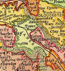
Grove is an unincorporated community in the southeastern portion of James City County in the Virginia Peninsula subregion of Virginia in the United States. It is located in the center of the Historic Triangle of Colonial Virginia, communities linked by the Colonial Parkway. This area is one of the busiest tourist destinations in the world.
Neersville is an unincorporated community in northwestern Loudoun County, Virginia, United States. It is located in the Between the Hills area of the Loudoun Valley on Harpers Ferry Road at the foot of Short Hill Mountain. It is notable for being the birthplace of Confederate guerrilla John Mobberly.

State Route 16 is a primary state highway in the southwest part of the U.S. state of Virginia. It runs from the North Carolina border at North Carolina Highway 16 north to the West Virginia border at West Virginia Route 16, passing through the towns of Troutdale, Marion, and Tazewell. Highway 16 is part of a three-state route 16 that connects the Charlotte region with northwestern West Virginia.

State Route 69 is a primary state highway in the U.S. state of Virginia. Known as Lead Mine Road, the state highway runs 3.59 miles (5.78 km) from SR 636 in Austinville east to U.S. Route 52 in Poplar Camp. SR 69 is the last remnant of a much longer route. At its peak from 1940 to 1945, this route ran from State Route 91 at Lodi east via St. Clair Bottom, Sugar Grove, Cedar Springs, Speedwell, Porters Crossroads, and Austinville to today's SR 69. However, it was never fully continuous; portions from Sugar Grove to Cedar Springs and west of Porters Crossroads to east of Austinville were secondary routes. The full length of this route as it existed and was planned is now part of SR 762, part of SR 660, all of SR 650, part of SR 16, all of SR 614, part of SR 749, part of US 21, part of SR 690, a small piece of SR 642, part of SR 619, part of SR 636, and SR 69.
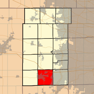
Sugar Grove Township is one of sixteen townships in Kane County, Illinois, USA. As of the 2010 census, its population was 19,618 and it contained 6,963 housing units. The Sugar Grove campus of Waubonsee Community College is within this township.
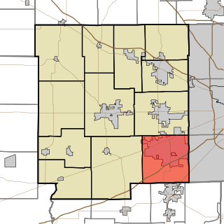
Guilford Township is one of twelve townships in Hendricks County, Indiana, United States. As of the 2010 census, its population was 27,844.

Spruce Mountain, located in eastern West Virginia, is the highest ridge of the Allegheny Mountains. The whale-backed ridge extends for only 16 miles (26 km) from northeast to southwest, but several of its peaks exceed 4,500 feet (1,400 m) in elevation. The summit, Spruce Knob, is the highest Allegheny Mountain point both in the state and the entire range, which spans four states.
Dale Enterprise is an unincorporated community in Rockingham County, Virginia, United States. The name dates to 1872, when it was time to name the village's post office. The place was previously known as Millersville, after the Miller family who ran an early store there. After the Civil War, Mr. J. W. Minnick started a new mercantile “enterprise” at the crossroads of Silver Lake Road and Route 33. Minnick’s store was located near a “dale,” so the chosen name became Dale Enterprise.

Short Hills Wildlife Management Area is a 4,232-acre (17.13 km2) Wildlife Management Area (WMA) located in Rockbridge and Botetourt counties, Virginia. It covers approximately 10 miles (16 km) of ridgeline along the Short Hills range.

Big Run is a river of 13 miles in length, located one-and-a-half miles west of Spruce Knob in Monongahela National Forest, in Pendleton County, West Virginia. It is a tributary of the North Fork South Branch Potomac River.

Clendenin Magisterial District is one of ten magisterial districts in Mason County, West Virginia, United States. The district was originally established as a civil township in 1863, and converted into a magisterial district in 1872. In 2020, Clendenin District was home to 3,435 people.

Union District, formerly Union Magisterial District, is one of five historic magisterial districts in Jackson County, West Virginia, United States. The district was originally known as Hushan's Mills Township, one of five civil townships established in 1863, at the height of the Civil War; it was subsequently given the patriotic name of Union Township. In 1872, West Virginia's townships were converted into magisterial districts. When Jackson County was redistricted in the 1990s, the area of Union District was included in the new Western Magisterial District. However, the county's historic magisterial districts continue to exist in the form of tax districts, serving all of their former administrative functions except for the election of county officials.


