
Lee County is a county in U.S. state of Mississippi. At the 2020 census, the population was 83,343. Lee County is included in the Tupelo Micropolitan Statistical Area.
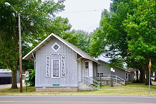
Manila is a city in Mississippi County, Arkansas, United States. The population was 3,682 at the 2020 census, up from 3,342 in 2010. It was the hometown of World War I sniper Herman Davis.

Clinton is a city in Hinds County, Mississippi, United States. Situated in the Jackson metropolitan area, it is the 10th most populous city in Mississippi. The population was 28,100 at the 2020 United States census.
The Yazoo River is a river in the U.S. states of Louisiana and Mississippi. It is considered by some to mark the southern boundary of what is called the Mississippi Delta, a broad floodplain that was cultivated for cotton plantations before the American Civil War. It has continued to be devoted to large-scale agriculture.

The Pearl River is a river in the U.S. states of Mississippi and Louisiana. It forms in Neshoba County, Mississippi from the confluence of Nanih Waiya and Tallahaga creeks, and has a meander length of 444 miles (715 km). The lower part of the river forms part of the boundary between Mississippi and Louisiana.

The Atchafalaya River is a 137-mile-long (220 km) distributary of the Mississippi River and Red River in south central Louisiana in the United States. It flows south, just west of the Mississippi River, and is the fifth largest river in North America, by discharge. The name Atchafalaya comes from Choctaw for 'long river', from hachcha, 'river', and falaya, 'long'.

The New Madrid Seismic Zone (NMSZ), sometimes called the New Madrid Fault Line, is a major seismic zone and a prolific source of intraplate earthquakes in the Southern and Midwestern United States, stretching to the southwest from New Madrid, Missouri.

The Ross Barnett Reservoir, often called the Rez, is a reservoir of the Pearl River between Madison and Rankin counties in the U.S. state of Mississippi. The 33,000-acre (130 km2) lake serves as the state's largest drinking water resource, and is managed by the Pearl River Valley Water Supply District. The lake features 105 miles (169 km) of shoreline impounded on the south by a 3.5-mile (5.6 km) man-made dam and spillway. The western shore is bounded by the historic Natchez Trace Parkway.
The Yockanookany River is a 78.4-mile-long (126.2 km) river in central Mississippi in the United States. It is a tributary of the Pearl River, which flows to the Gulf of Mexico.

William John McGee, LL.D. was an American inventor, geologist, anthropologist, and ethnologist, born in Farley, Iowa. He always referred to himself as J W McGee, without period.

The Chippewa River is a 153-mile-long (246 km) tributary of the Minnesota River in western and southwestern Minnesota in the United States. Via the Minnesota River, it is part of the watershed of the Mississippi River.
Miss Mississippi is a scholarship pageant and a preliminary of Miss America. The contest began in 1934, has been held in Vicksburg since 1958, and provides more money than any other scholarship pageant in the Miss America Organization.

Stafford Springs, Mississippi is an unincorporated community located in Jasper County, Mississippi, United States, along U.S. Route 11.
University is a census-designated place (CDP) and the official name for an area covering a portion of the University of Mississippi campus, in Lafayette County, Mississippi, United States. The CDP is surrounded by the city of Oxford. Its official United States Postal Service designation is "University, Mississippi", with a ZIP Code of 38677.
Runnelstown is a census-designated place and unincorporated community located in Perry County, Mississippi.
Enid is an unincorporated community located in Tallahatchie County, Mississippi, United States. Enid is located near U.S. Highway 51 approximately 7 miles (11 km) north of Oakland, Mississippi and approximately 9 miles (14 km) south of Pope, Mississippi.

U.S. Route 60 and U.S. Route 62 (US 60/US 62) run for a very short distance within the state of Illinois. The highways run concurrently for their entire existence within the state. The joint highway runs around Fort Defiance in Cairo, from the Cairo Mississippi River Bridge over the Mississippi River east to the Cairo Ohio River Bridge over the Ohio River; the Ohio River Bridge also carries US 51. The bridges cross the two rivers just north of the mouth of the Ohio.
Mashulaville is an unincorporated community in Noxubee County, Mississippi, in the United States.

Mississippi Highway 570 (MS 570) is a two-segment state highway in the U.S. state of Mississippi that travels in the vicinity of McComb. The western segment runs from U.S. Route 98 (US 98) in Franklin County to US 51 in McComb. The eastern segment runs from MS 44 in McComb to MS 44 near Pricedale.


