McNulty, Oregon | |
|---|---|
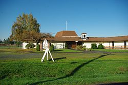 Calvary Lutheran Church at McNulty | |
 McNulty  McNulty | |
| Coordinates: 45°50′24″N122°50′31″W / 45.84°N 122.842°W | |
| Country | United States |
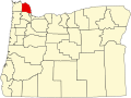
| State | Oregon |
| County | Columbia |
| Elevation | 115 ft (35 m) |
| Time zone | UTC-8 (Pacific (PST)) |
| • Summer (DST) | UTC-7 (PDT) |
| ZIP code | 97053 |
| Area codes | 503 and 971 |
McNulty is an unincorporated community in Columbia County, Oregon, United States. [1] It was named for Columbia River steamboat captain John McNulty, a pioneer riverboatman of the Pacific Northwest. [2]