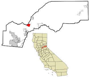
Meadow Vista is a census-designated place (CDP) in Placer County, California, United States. It is part of the Sacramento–Arden-Arcade–Roseville Metropolitan Statistical Area. The population was 3,217 at the 2010 census, up from 3,096 at the 2000 census.

Oakdale is a village in Antelope County, Nebraska, United States. The population was 322 at the 2010 census.

Amherst is a village in Buffalo County, Nebraska, United States. It is part of the Kearney, Nebraska Micropolitan Statistical Area. The population was 248 at the 2010 census.

Eagle is a village in southwest Cass County, Nebraska, United States. As of the 2020 census, the village population was 1,065.

Elmwood is a village in southeast Cass County, Nebraska, United States. The population was 654 at the 2020 census.

Greenwood is a village in northwest Cass County, Nebraska, United States. The population was 595 at the 2020 census.

Murray is a village in Cass County, Nebraska, United States. The population was 480 at the 2020 census.

Callaway is a village in Custer County, Nebraska, United States. The population was 539 at the 2010 census.

Uehling is a village in Dodge County, Nebraska, United States. The population was 230 at the 2010 census.

Boys Town is a village in Douglas County, Nebraska, United States. The population was 410 at the 2020 census. Boys Town is an enclave and a suburb of Omaha.

Waterloo is a village in Douglas County, Nebraska, United States. The population was 935 at the 2020 census.

Milligan is a village in Fillmore County, Nebraska, United States. The population was 241 at the 2020 census.

Stuart is a village in Holt County, Nebraska, United States. The population was 590 at the 2010 census.

Elba is a village in Howard County, Nebraska, United States. The population was 215 at the 2010 census. It is part of the Grand Island, Nebraska Micropolitan Statistical Area.

Heartwell is a village in Kearney County, Nebraska, United States. It is part of the Kearney, Nebraska Micropolitan Statistical Area. The population was 80 at the 2020 census.
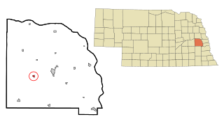
Center is a village in, and county seat of, Knox County, Nebraska, United States. The population was 73 at the 2020 census.

Prague is a village in Saunders County, Nebraska, United States. The population was 291 at the 2020 census. It was named after Prague, capital of Bohemia.
Weston is a village in Saunders County, Nebraska, United States. The population was 250 at the 2020 census.

Sugar Grove is a village in Fairfield County, Ohio, United States. The population was 429 at the 2020 census.

Newman Grove is a city in Madison and Platte counties in Nebraska, United States. The population was 667 at the 2020 census.


