Meadvale

Last updated

Meadvale
Furzefield Crescent (geograph 1696178).jpg
A central green-buffered estate of Meadvale
Earlswood Common - geograph.org.uk - 1214888.jpg
Earlswood Common is a park of similar size to Meadvale, adjoining it to the south and includes play areas and Redhill and Reigate Golf Course.
Surrey UK location map.svg
Red pog.svg
Meadvale
Meadvale shown within Surrey
Population3,090 2011 Census [1]
OS grid reference TQ267491
District
Shire county
Region
Country England
Sovereign state United Kingdom
Post town REDHILL
REIGATE
Postcode district RH1
RH2
Dialling code 01737
Police Surrey
Fire Surrey
Ambulance South East Coast
EU Parliament South East England
UK Parliament
List of places
UK
England
Surrey
51°13′38″N0°11′13″W / 51.22721°N 0.18707°W / 51.22721; -0.18707 Coordinates: 51°13′38″N0°11′13″W / 51.22721°N 0.18707°W / 51.22721; -0.18707

Meadvale or less commonly Mead Vale is a southern residential suburb that straddles borders of Redhill and Reigate in the borough of Reigate and Banstead in Surrey, and one of two which do so. The average elevation of the district is higher than the centres of each of the towns – Meadvale is bisected east-west by the Greensand Way at the top of a moderately low section of the Greensand Ridge. Its population, as broadly defined on its ward definition, is 3,090 spread over 64 hectares (160 acres) based upon the most recent national census.

Redhill, Surrey town in Reigate and Banstead, Surrey, England

Redhill is a town in the borough of Reigate and Banstead within the county of Surrey, England. The town, which adjoins the town of Reigate to the west, is due south of Croydon in Greater London, and is part of the London commuter belt. The town is also the post town, entertainment and commercial area of three adjoining communities: Merstham, Earlswood and Whitebushes, as well as of two small rural villages to the east in the Tandridge District, Bletchingley and Nutfield.

Reigate A town in Surrey, England

Reigate is a town of over 20,000 inhabitants in eastern Surrey, England. It is in the London commuter belt and one of three towns in the borough of Reigate and Banstead. It is sited at the foot of the North Downs and extends over part of the Greensand Ridge. Reigate has a medieval castle and has been a market town since the medieval period, when it also became a parliamentary borough.

Reigate and Banstead Place in England

Reigate and Banstead is a local government district with borough status in East Surrey, England. It includes the towns of Reigate, Redhill, Horley and Banstead. The borough borders the Borough of Crawley to the south, the Borough of Epsom and Ewell and District of Mole Valley to the west, Tandridge District to the east and the London Boroughs of Sutton and Croydon to the north.

Contents

Geography

Meadvale is contiguous with the 'town centre' of Reigate and Linkfield or Linkfield Street which is mostly part of Redhill and the only other suburb shared between the two post towns. Meadvale has the Greensand Way, a path cutting through its centre on a low, lightly wooded stretch of the Greensand Ridge. The ridge spans most of Kent and all of Surrey and is quite steep, e.g. reaching Leith Hill, and (until the 19th century) traditionally having no villages on its crest, it is relatively densely and using many listed buildings built upon at St John's, Redhill directly east of the suburb. [2] [3]

Greensand Way

The Greensand Way is a long distance path of 108 miles (174 km) in southeast England, from Haslemere in Surrey to Hamstreet in Kent. It follows the Greensand Ridge along the Surrey Hills and Chart Hills. The route is mostly rural, passing through woods, and alongside fruit orchards and hop farms in Kent and links with the Stour Valley Walk near Pluckley in Kent. The trail was opened on 15 June 1980 and is jointly managed by Surrey and Kent Councils who fully updated it in 2012.

Greensand Ridge sandstone escarpment and range of hills in south-east England

The Greensand Ridge is an extensive, prominent, often wooded, mixed greensand/sandstone escarpment in south-east England. It runs to and from the East Sussex coast, around the Weald, a former dense forest in Sussex, Surrey and Kent. It reaches its highest elevation, 294 metres (965 ft), at Leith Hill in Surrey—the second highest point in south-east England, while another hill in its range, Blackdown, is the highest point in Sussex at 280 metres (919 ft). The eastern end of the ridge forms the northern boundary of Romney Marsh.

Leith Hill hill of surrey

Leith Hill is a wooded hill 7 kilometres (4.3 mi) to the south west of Dorking, Surrey, England. It reaches 294 metres (965 ft) above sea level, the highest point on the Greensand Ridge, and is the second highest point in south-east England, after Walbury Hill near Newbury, Berkshire, 297 metres (974 ft) high. Leith Hill is the highest ground for 49 miles (79 km). Wooded areas surrounding the hill are designated Leith Hill Site of Special Scientific Interest

The traditional heart of the suburb is to the south, where for instance, Palmer lived, and within the Redhill rather than the Reigate post town. On the other hand, in economics and leisure apart than the considerable facilities of adjoining Earlswood Common park, the nearby major town centre is Reigate, which adjoins the northern half.

A post town is a required part of all postal addresses in the United Kingdom, and a basic unit of the postal delivery system. Including the correct post town in the address increases the chance of a letter or parcel being delivered on time. Post towns in general originated as the location of delivery offices. As of 2004, their main function is to distinguish between locality or street names in addresses not including a postcode.

Elevations range from 132m above sea level in the centre to 72m on the southern border, a road that demarcates Earlswood Common, a large open space.

Demography

The United Kingdom Census 2011 considered the suburb as output layers 'Reigate and Banstead 012C and 013B', i.e. north and south parts, approximately half of the ward Meadvale and South Park, the latter being an area of Reigate to the south-west. The halves of Meadvale were considerably less densely populated, with larger single family homes with gardens, towards the highest area, the central east-west belt of the district than their lowest north and south borders.

The proportion of households in Meadvale who owned their home outright was within 2% of the borough and regional average. The proportion who owned their home with a loan was 17% and 6.2% greater respectively than the regional average; providing overall in each area for a lower proportion than average of rented residential property and of social housing, and close to the average in Surrey. [1]

Surrey County of England

Surrey is a subdivision of the English region of South East England in the United Kingdom. A historic and ceremonial county, Surrey is also one of the home counties. The county borders Kent to the east, East Sussex and West Sussex to the south, Hampshire to the west, Berkshire to the northwest, and Greater London to the northeast.

2011 Census Key Statistics
Output areaPopulationHouseholds% Owned outright% Owned with a loanhectares [1]
Reigate & Banstead 012C1,59261633.352.1 [1] 42 [4]
Reigate & Banstead 013B1,49860336.341.322 [5]

History

Post-Norman Conquest land use

The developed history of the area is that of Redhill until the 19th century. All of this area was in the first of its three parishes: much of large, non-borough status 'Reigate Foreign' as opposed to adjoining bustling, (even before 1832) urban Reigate (Parliamentary) Borough, coupled with to the north outcrops of Gatton and Merstham which were until the 20th century sparsely inhabited villages. Of relevance to political and social history, Gatton was a borough too but a rotten borough, meaning it suffered from severe malapportionment until it was abolished in 1832. These remain rural and arguably suburban respectively north of the twin towns. [6]

Development as a brickfields town, coach town, market town and commuter settlement

By the late 19th century, Reigate Foreign's own community and incoming migrants had developed six relatively densely inhabited pockets of housing: 'Linkfield Street', Hooley, 'Wiggy', 'Little London', 'Warwick Town' and Meadvale, particularly as compared that is to much of the surrounding fields and woodland. Beside Redhill railway station (named only after the nearest common land) neatly placed by the early 19th century redirected London-Brighton Road a recognisable, market town-style High Street had developed by approximately 1880, four decades after that station was built, but still termed Warwick Town commonly on maps and in official records. These combined 'hub' factors led to a railway junction town and staging town of considerable size, attracting new local industries. Particularly, brickfields for London, provided major employment. [6]

Social and economic features within Meadvale

Meadvale was known in the 19th century as Meads Hole. The name means meadowland hollow. Here not only dwellings but also pottery businesses scattered over the common land – some kilns remain. The major hamlet had two butchers, a baker, a draper, a tailor and a grocer's shop.[ citation needed ] The first school was held in the village hall with a fee of one penny a week for each child. At the beginning of the 19th century, there was a tanner's yard adjoining Earlswood Common which was pasture, not park, at the southern entrance to Meadvale. [6]

20th century history

The development expanded, spurred by demand stimulated by the rise in professions in London, of trade, building and manufacturing across the county and particularly catering to fewer brickfields workers, leaving Edwardian architecture one of the enduring types of building. In this centre planning policies and decisions were made by the Borough of Reigate, followed by Reigate and Banstead Borough Council. A string of bombs was dropped on the area during the Blitz of World War II causing injury and destruction to a minority of properties. [7]

Notable people

The painter Samuel Palmer lived his later working years, when he painted Surrey principally, in Meadvale at the Chantry on Cronks Hill Road until his death in 1881. [8] [9] [10]

See also

Related Research Articles

Epsom and Ewell Place in England

Epsom and Ewell is a local government district with borough status in Surrey, England, covering the towns of Epsom and Ewell. The borough was formed as an urban district in 1894, and was known as Epsom until 1934. It was made a municipal borough in 1937. The district was considered for inclusion in Greater London in 1965 but was left unaltered by the London Government Act 1963 and the Local Government Act 1972 in 1974. However, despite being outside modern Greater London the borough was in the Metropolitan Police District until it was transferred to Surrey Police in 2000. In the May 2011 elections, the borough was held by the Epsom and Ewell Residents Association with 26 seats, Liberal Democrats with 6 seats and both the Labour and Conservatives with 3 seats.

Horley town in Surrey, England

Horley is a town in the borough of Reigate and Banstead in Surrey, England south of the towns of Reigate and Redhill. The county border with West Sussex is to the south with Crawley and Gatwick Airport close to the town. With fast links by train round-the-clock to London from Horley railway station, it qualifies as a commuter town and has a significant economy of its own, including business parks and a relatively long high street.

Reigate (UK Parliament constituency) Parliamentary constituency in the United Kingdom, 1885 onwards

Reigate is a constituency represented in the House of Commons of the UK Parliament since 1997 by Crispin Blunt of the Conservative Party.

Salfords village in United Kingdom

SalfordsSAL-fudz) is a village in the borough of Reigate and Banstead in Surrey, England. It lies approximately 3 miles (4.8 km) south of Redhill on the A23 London to Brighton road. The village is within the civil parish of Salfords and Sidlow which covers a population of 3,069, and has a parish council.

Banstead a town in England, United Kindom

Banstead is a residential town/village in the borough of Reigate and Banstead in Surrey, England, on the border with London, 2.5 miles (4 km) south of Sutton, 5 miles (8 km) west of Croydon and 7.5 miles (12 km) south-east of Kingston-upon-Thames and 13.3 miles (21 km) south of Central London. The county town, Guildford is 17 miles (27 km) west south-west.

Earlswood suburb of Redhill, Surrey

Earlswood is a suburb of Redhill in Surrey, England forming the south of the town of Redhill, and part of its RH1 postcode district. Earlswood lies on the A23 between Redhill and Horley, from which the neighbouring community, Whitebushes is separated by a wide rural buffer zone. The two main southern communities of Redhill are in local administration grouped together to form a ward, Earlswood and Whitebushes. Earlswood Common is a Local Nature Reserve that separates the suburb from the southern suburbs of Reigate, and has two lakes known as Earlswood Lakes, picnic areas and a golf course. South Earlswood is contiguous with Whitebushes but is also to the west. East of its station and the Brighton Main Line are three unconnected estates: east Earlswood; Royal Earlswood Park and East Surrey Hospital with Whitebushes.

Tattenham Corner village in United Kingdom

Tattenham Corner is a neighbourhood in north Surrey, UK, but the name is principally associated with Epsom Racecourse. It is in the Tattenhams ward of Reigate and Banstead Borough.

Burgh Heath village in United Kingdom

Burgh Heath is a residential neighbourhood with a remnant part of the Banstead Commons of the same name. Immediately north of Upper Kingswood on the A217 road, it adjoins part of Banstead to the north. The north of the area is more specifically called Great Burgh, but the terms are largely interchangeable.

Chipstead, Surrey village in United Kingdom

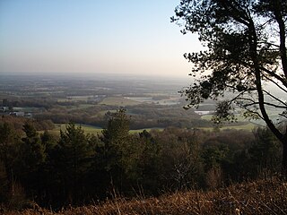
Chipstead is a predominantly commuter village in north-east Surrey, England, that has been a small ecclesiastical parish since the Domesday Survey of 1086. Its rolling landscape meant that Chipstead's development was late and restricted compared to parishes of comparable distance from London. Formerly and formally including Hooley and Netherne-on-the-Hill, on census day, 1831 Chipstead had 66 homes. Today, excluding those two parts, the village has 1,212 homes spread across the slopes and crests of a northern section of the North Downs. Parts of the village are in or adjoin the Surrey Hills AONB.

Reigate was a hundred in what is now Surrey, England. It was geographically consonant with the southern two thirds of Borough of Reigate and Banstead together with two parishes in Tandridge and fractions of former parishes in the London Borough of Croydon and Borough of Crawley, West Sussex. Accordingly, it included the medieval-established town of Reigate with its motte castle and land which become the towns of Redhill and Horley.

One third of Reigate and Banstead Borough Council in Surrey, England is elected each year, followed by one year without election. Since the last boundary changes in 2000, 51 councillors have been elected from 19 wards.

Gatton, Surrey village in the United Kingdom

Gatton was a former village and borough in Surrey, England, and an ancient parish. It survives as a sparsely populated, predominantly rural locality, which includes Gatton Park, no more than 12 houses, and two farms on the slopes of the North Downs near Reigate.

Margery Hamley in Surrey, England

Margery is a heavily buffered, lightly populated hamlet in the Reigate and Banstead district, in the English county of Surrey. It sits on the North Downs, is bordered by the London Orbital Motorway, at a lower altitude, and its predominant land use is agriculture.

Earlswood Common

Earlswood Common is an 89.1-hectare (220-acre) Local Nature Reserve in Redhill in Surrey. It is owned and managed by Reigate and Banstead Borough Council.

References

  1. 1 2 3 4 Key Statistics United Kingdom Census 2011, Office for National Statistics
  2. OS Map with Listed Buildings and Parks marked Archived 24 April 2012 at the Wayback Machine .
  3. Grid square map Ordnance survey website
  4. 2011 Census published as above
  5. 2011 Census published as above
  6. 1 2 3 H.E. Malden (editor) (1911). "Parishes: Reigate". A History of the County of Surrey: Volume 3. Institute of Historical Research. Retrieved 5 November 2013.
  7. People's war stories
  8. Campbell-Johnston, Rachel, (2011) Mysterious Wisdom: The Life and Work of Samuel Palmer, London, Bloomsbury.
  9. Lister, Raymond (1974). Samuel Palmer, A Biography Faber and Faber, London ISBN   0-571-09732-4
  10. Lister, Raymond ed The Letters of Samuel Palmer OUP, Oxford 1974 ISBN   978-0-19-817309-0