Kingswood, Surrey

Last updated

Kingswood
Rainbow over Kingswood Warren - geograph.org.uk - 137535.jpg
Kingswood Warren Park
Renovated and subdivided 2012
The 'Kingswood Arms', Surrey - geograph.org.uk - 612544.jpg
The Kingswood Arms
Surrey UK location map.svg
Red pog.svg
Kingswood
Location within Surrey
Population6,891 (2011 Census) [1] [n 1]
OS grid reference TQ248559
District
Shire county
Region
Country England
Sovereign state United Kingdom
Post town Tadworth
Postcode district KT20
Dialling code 01737
Police Surrey
Fire Surrey
Ambulance South East Coast
UK Parliament
List of places
UK
England
Surrey
51°17′35″N0°12′31″W / 51.2931°N 0.2086°W / 51.2931; -0.2086

Kingswood or Kingswood with Burgh Heath is a residential area on the North Downs in the borough of Reigate and Banstead in Surrey, England. Part of the London commuter belt, Kingswood is just to the east of the A217 separating it from Tadworth and has a railway station. Burgh Heath in its north is combined with it to form a ward. Reigate is 3.6 miles (5.8 km) south of its centre and London is 15.5 miles (24.9 km) to the north northeast. Kingswood with Burgh Heath had a population of 6,891 in 2011. [2]

Contents

History

Middle Ages

The first specific reference to the land which later charters, parish, hundred and county maps state to be Kingswood is in the Domesday Book, where a passage in the entry for Ewell states that "2 hides and 1 virgate were removed from this manor; they were there before 1066, but reeves lent them to their friends; and 1 woodland pasture and 1 croft" – Ewell's Lords of the manor in 1086 were Osbern of Eu (held of King William) and King William himself. [3]

Henry II granted it with Shelwood much further detached, in the Weald, as parcel of the manor of Ewell to Merton Priory, [4] who in 1291 were given licence to inclose the wood of Kingswood as "it was their own soil and without the bounds of the royal hunting forest" – see Windsor Great Park. [4]

From Domesday Kingswood, including Lower Kingswood and much of Burgh Heath was a detached part of the parish of Ewell. Between it the Banstead commons of Banstead including what is now Tadworth stretched to Reigate forming a buffer particularly for the parish of Walton-on-the-Hill. [3] [5] The wider Copthorne Hundred was a royal hundred. Kingswood by being a liberty was excluded. That hundred around on all sides but the south was worth almost £48 in the 14th century and £136 16s. 4d. in 1636. [n 2]

Burgh Heath however was recorded, appearing as Burgh, held in 1086 by Hugh of Port of Bishop Odo of Bayeux, his overlord; its assets were 5 exemption units (large estates) for which it was taxed on 2.5. [6]

Early Chapel

There was a chapel in the far-removed hamlet of Kingswood which had existed long before the middle of the 15th century; for when the vicarage of Ewell was endowed in 1458, it is mentioned as of long standing. Mention occurs towards the close of the reign of Edward I of England. [7] A church ruling stipulated that the vicar of Ewell should not be obliged to minister to the hamlet of Kingswood or to celebrate Mass in the chapel there; that when any of the Sacraments of the Church were to be administered to the people of that place, the rectors (Prior and convent of Newark) should provide a priest for the purpose; and in case of the death of any inhabitant of Kingswood and his removal to Ewell for burial, the vicar should meet the body at Provost's Cross, on the south side of Ewell, which had been the custom from ancient time. [8] The subsequent history of this chapel is obscure.

Post Reformation

Kingswood Manor

Nonetheless, on the dissolution of the monasteries (1536–8) King Henry VIII seized Kingswood Manor that comprised almost all the land of Kingswood, earlier valued at £14 6s. 8d in 1535, annexing it to the honour of Hampton Court [4] (its purview).

Queen Elizabeth I bestowed it to the first Lord Howard of Effingham for annual service of 140 of a knight's fee, kept until sold by his grandson who was also Earl of Nottingham. [4] As granted to a cavalier by a loyal brother who served Cromwell, a roundhead, the Manorial roll has no mention of Sir John Heydon holding court at the manor; it passed to a relative of Howard's wife Charles Cockayne, another royalist who on in 1656 conveyed it to Thomas Bludworth. Bludworth of Flanchford, Reigate held it on the Restoration until October 1660, holding court for years until 1698, when his son took over, then sold it in 1703 to Lynch and Brandon as trustees for Thomas Harris, who held a court in 1708. Kingswood Manor then descended to his son Thomas, whose nephew John Hughes in 1791 sold the manor to William Jolliffe, whose son Hylton Jolliffe was owning it in 1804, selling it in about 1830 to Thomas Alcock, from whose executors it was bought by Sir John Hartopp, and from his trustees by H. Cosmo Bonsor.

Other occurrences at this time

In this era today's Brighton Road through Croydon and Redhill, the A23 replaced the Old Brighton road which came up Reigate Hill, passed through Lower Kingswood and by Upper Kingswood and on into Sutton, which is now the A217, preventing development of the area. [4]

In 1632 and from 1669 to 1812 St Mary the Virgin Church, Ewell maintained separate Kingswood books with all the conformist births, deaths and marriages of Kingswood.

Post Industrial Revolution

Kingswood was until the early 20th century the administrative unit of Kingswood Liberty see Liberty (division), of 1,821 acres (737 ha), a completely detached part of Ewell parish, bounded on the west and north by Banstead, on the east by Chipstead and Gatton, on the south by Reigate. [4]

Based on the 1841 census, Samuel Lewis writes of Kingswood in 1848 there were 848 inhabitants and, in brief, consisted of 1,800 acres (730 ha) of which 400 were woodland and the remainder almost wholly arable. [7] Kingswood Warren (house) was built about 1850, see Landmarks.

In 1838 an ecclesiastical district was formed from a new church costing over £1100 consecrated 14 January 1836 from Kingswood with a portion of Banstead, [7] and a newer church, St. Andrew's, was built in 1848 by Thomas Alcock. Malden states in 1911 that the old church in 1911 was used as a parish room and the church was still endowed with a glebe of 31 acres. [4] Kingswood Methodist chapel was built by the late H. Fowker however has been converted. [9]

Kingswood became in 1899 the terminus of a branch of the South Eastern and Chatham Railway, now the Tattenham Corner branch. Writing in 1911, Malden states: the neighbourhood which used to be singularly sequestered and rural is fast becoming residential, especially since the opening of the railway. But the majority of the new houses are in the part of Banstead included in the ecclesiastical parish of Kingswood, not in the old portion of Ewell.

Lower Kingswood School was built in 1893 and enlarged in 1903. Tadworth and Kingswood School (in Banstead parish) was built in 1875. Both are County Council Schools.

Kingswood is today characterised by housing which is described as arcadian, which implies it is 'spacious and tree-dominated'. [10]

Kingswood was formerly a liberty and chapelry, [11] in 1866 Kingswood became a separate civil parish, [12] on 1 April 1974 the parish was abolished. [13] In 1951 the parish had a population of 3606. [14]

Geography

Elevation, geology and soil

The entire ward sits on top of the North Downs and, taken as a whole, slopes gradually from 200m AOD in the south to 170m AOD in Upper Kingswood in the north. [15] Kingswood is rectangular, less than 3 miles from north to south, and is under a mile broad. [4]

Upper watercourses cut gentle valleys in this ward including between Lower Kingswood and Upper Kingswood where the land dips from 174m AOD in Lower Kingswood to 144 along Chipstead Lane that divides Lower and Upper Kingswood and is closer to Lower Kingswood – three residential streets around Chipstead Lane form Hogden Bottom, Lower Kingswood including Chipstead Lane itself. This ravine is accompanied by another, along which the Kingswood railway runs towards London, further down this joins the Hogden stream at Chipstead Bottom in a short distance at the east edge of the ward: here the elevation is only 111m AOD.

Upper Kingswood is lower than much of Lower Kingswood, however its gradients are less steep than the depths of Hogden Bottom between the two, fractionally closer to the developed southern part of Lower Kingswood and possibly considered part of it therefore. [16] The main street is on average at a modest 166m AOD, with the central, station section at 147-152m AOD. Below to the northeast and northwest are Sutton and Epsom at 30-40m at their centres. The folding landscape around both explains the misnomer among the names. [16]

Its geology is that of the North Downs, see Surrey – Geology; as to soil Chipstead, Banstead and Tadworth have the first free draining slightly acid loamy soil that tops the wider downs to Guildford and is found around Dorking. [17]

Localities

Manor Lane
Lower Kingswood Manor Lane, Lower Kingswood - geograph.org.uk - 364003.jpg
Manor Lane
Lower Kingswood
Modernist housing at Burgh Heath - taken at dusk Modernist housing - geograph.org.uk - 1636489.jpg
Modernist housing at Burgh Heath – taken at dusk
Footpath towards Canons Wood on Burgh Heath Footpath towards Canons Wood - geograph.org.uk - 584557.jpg
Footpath towards Canons Wood on Burgh Heath

Upper Kingswood or Kingswood

This area had a population of 2,839 forming 1,055 households at the time of the 2001 Census. [1] A garden residential estate bounded on the west by a narrow woodland green buffer separating the A217, which can only be accessed in both directions at the "Tadworth" roundabout, Kingswood Park, Garden Farm and the International School of Minting occupies the northwest; Kingswood Warren garden estate, the southwest. [16] Reigate is 4 miles (6.4 km) south of its centre and London is 15.5 miles (24.9 km) to the NNE. [15]

Kingswood village centre has several independent shops, a large mock-Tudor public house, the "Kingswood Arms", and Kingswood railway station in the dip of the main street, Waterhouse Lane. To the south side of the shopping parade is part of the undeveloped Green Belt giving views of the open fields of Garden Farm and meadows of Kingswood Park.

Lower Kingswood

This settlement had a population of 2,099 forming 1,067 households at the time of the 2001 Census - [1] the locality slopes down the A217, accessible to many properties and side-roads. Built-up side roads include: Buckland Road which has Kingswood Primary School; Stubbs Lane (the two meet at a high point of 191m AOD [16] ); Babylon Lane (by Kingswood Grange and Kingswood Manor); Smithy Lane and Green Lane. Kingswood recreation ground is here with tennis courts, playground and a pavilion for football pitches, bowls, park and woodland. [18]

Burgh Heath

Burgh Heath is a residential area (neighbourhood) with remnant part of the Banstead Commons of the same name. Immediately north of Upper Kingswood on the A217 road, it adjoins Banstead. Nork, Banstead is the neighbourhood directly north. The dual carriageway has meant that today there are two separate areas of housing: a larger part with shops on the main road and surrounding Canons Lane to the east and the other to the west close to the ponds, facing Burgh Heath and to distinguish it from the built up section, known to its residents as The Green. Burgh Heath had a population of 2,099 forming 839 households at the time of the 2001 Census. [1]

Burgh Heath has a large supermarket store, a luxury sports car garage and Toyota's UK headquarters are located in the north of the area at Great Burgh. There is a parade of shops along the A217 of small independent retailers and several small restaurants. However, the majority of residents in the area are commuters out of the area.

Open areas of Burgh Heath

The residential area is bordered to the south by the Burgh Heath itself, one of four parts of Banstead Commons, managed by the Banstead Commons Conservators and its byelaws. It is bordered east and north by farmland leading to Banstead Woods, managed by local authority Reigate and Banstead borough council. [19]

Beside the supermarket is a triangular wood in part of which is Burgh Heath BMX Track. [18]

Mugswell

On a very sparsely built upon part of the southern part of the same crest of the North Downs, traditionally in Banstead parish also, hence in the Banstead Heath protected area, is a small hamlet named Mugswell. It is separated by a narrow green buffer south of Kingswood and another, ENE of Lower Kingswood.

Transport

A junction of the M25 is close to the village. Railways do not pass by the small settlement: its closest stations are Kingswood and Tadworth, more than a mile away. Low-frequency bus services do serve nearby Lower Kingswood.

Landmarks

Kingswood Warren

Kingswood Warren is a battlemented gothic mansion to the south of the village, much enlarged in the early nineteenth century by the architect T.R. Knowles for its owner Thomas Alcock M.P. [20] From 1948 until 2010 it was used to house the BBC's Research and Development department. [21] Octagon Developments completed the purchase of Kingswood Warren on 1 March 2010 and it gives its name to the garden estate of south Upper Kingswood. [16]

Kingswood Court

Kingswood Court is larger than and occupies a larger site than the surrounding houses in Kingswood Warren, except for the building Kingswood Warren mentioned above. Ernest Newton was its architect, in terms of size, its main range consists of 11 bays plus a 3-bay west service wing, symmetrically laid out with five bays as bay windows. Constructed from purplish red bricks laid in flemish bond with red brick dressings, it spans three storeys including a purpose-built servant area attic and is georgian in character. This enjoys preservation and upkeep today as a private care home with landscaped gardens. [22]

St Andrew's Church

Kingswood war memorial Kingswood War Memorial - geograph.org.uk - 7032.jpg
Kingswood war memorial

The original church of St Andrew was built in 1835, in a "Norman" style of architecture, accommodating a congregation of 150. [20] It was consecrated in 1836 and became a parish church in 1838. It soon proved too small for the growing population and in 1848 work began on a larger building on another site. The present St. Andrew's Church was built between 1848 and 1852 at the expense of the then owner of Kingswood Warren, Thomas Alcock. St Andrew's is an exact copy of the 14th century church at Shottesbrooke, Berkshire under the supervision of the architect Benjamin Ferrey. [23] In younger years Thomas Alcock had been a frequent house guest of the Vansittart family at Shottesbrooke Park in Berkshire and worshipped at the church there. The old church served as a parish hall until its demolition in the early twentieth century. [23] Cruciform in shape and splendid with beautiful stained glass windows; its tall distinctive steeple is visible for miles around. [24]

St Mary's Church, Burgh Heath

This church is further down the London Road, past the Burgh Heath junction with the road to Epsom. The parish of this Church of England church is Howell Hill with Burgh Heath and it was built in 1909, and its area is worked together with Howell Hill in East Ewell. [25]

Lower Kingswood Church – The Church of Jesus Christ and the wisdom of God

Kingswood's Church of Jesus Christ and the Wisdom of God, an Anglican Church built in the Byzantine style is unique in Europe. It marks the start of Buckland Road and is a Grade I listed building on architecture, it features red brick and stone in various patterns e.g. chequer work, herringbone and basketweave; exotic marble and other stone, [4] nine imported corinthian capitals from Turkey, Arts and Crafts movement lectern, pulpit and reading desk, in ebony and holly with mother of pearl inlay, priests' chairs with domed canopies, Byzantine capitals from Constantinople and Ephesus decorate the aisles and west wall. [26]

The name of the church is reflected in those words from 1 Corinthians carved over the west door. [27]

Entrance to Legal and General Insurance, Furze Hill, Kingswood Entrance to Legal and General Insurance, Furze Hill, Kingswood.jpg
Entrance to Legal and General Insurance, Furze Hill, Kingswood

The financial services company Legal & General had one of its largest offices (not its registered office) at a site on the northern outskirts of Kingswood, until the office was closed in late 2017. Legal & General's former corporate training centre, known as St Monica's, was once a girls' boarding school of the same name. A notable former student was the author Vera Brittain. [28]

The 3rd Tee, Surrey Downs Golf Club The Third Tee - geograph.org.uk - 20445.jpg
The 3rd Tee, Surrey Downs Golf Club

Kingswood Golf and Country Club

Kingswood Golf and Country Club occupies the south of the Kingswood Warren with fine views over Smuggler's Pit Plantation, above the small valley, Hogden Bottom. [16] James Braid, five times Open champion, opened in the 1920s this venue as a 6,954 yard course. Today this offers weddings, catering and conferences "the mature course has undergone extensive re-design and construction.". [29]

Surrey Downs Golf Club

Occupying an adjacent site, in what was Eyhurst Park, on the Chipstead side, is another 18-hole golf club. [30]

Transport

Bus

No bus services pass through the village. The nearest bus stop is on the A217, on the side of the Tadworth roundabout, for services to Reigate and Redhill; or for services to Epsom and Sutton the stop is across the A217 opposite Tadworth Children's Hospital.

Rail

Kingswood railway station is on the Tattenham Corner Line, close to the centre of the village. London Bridge is 42 minutes from Kingswood station; East Croydon is 23 minutes [31]

Road

The A217 is a non-motorway route into London bisecting the ward, combined with the A240 road from Burgh Heath, provides easy journeys within the capital. The M25 London Orbital Motorway's junction 8 is at the south of the ward, accessed by the former straight road. As mentioned the ward is less than 3 miles (4.8 km) in length so 1.5 miles (2.4 km) is the maximum distance away from this route from any given point. [16]

Education

Nearby schools taking their name from Kingswood

Famous residents

Related Research Articles

<span class="mw-page-title-main">Reigate and Banstead</span> Borough and non-metropolitan district in England

Reigate and Banstead is a local government district with borough status in Surrey, England. Its council is based in Reigate and the borough also includes the towns of Banstead, Horley and Redhill. Parts of the borough are within the Surrey Hills, a designated Area of Outstanding Natural Beauty. Northern parts of the borough, including Banstead, lie inside the M25 motorway which encircles London.

<span class="mw-page-title-main">Tadworth</span> Human settlement in England

Tadworth is a large suburban village in Surrey, England in the south-east of the Epsom Downs, part of the North Downs. It forms part of the Borough of Reigate and Banstead. At the 2011 census, Tadworth had a population of 7,123

<span class="mw-page-title-main">Reigate (UK Parliament constituency)</span> United Kingdom parliamentary constituency

Reigate is a constituency in Surrey represented in the House of Commons of the UK Parliament since 1997 by Crispin Blunt, originally of the Conservative Party, but as of October 2023, sitting as an Independent, after having the whip suspended.

<span class="mw-page-title-main">Banstead</span> Town in Surrey, England

Banstead is a town in the borough of Reigate and Banstead in Surrey, England. It is 3 miles (5 km) south of Sutton, 5 miles (8 km) south-west of Croydon, 8 miles (13 km) south-east of Kingston-upon-Thames, and 13 miles (21 km) south of Central London.

<span class="mw-page-title-main">Tattenham Corner</span> Human settlement in England

Tattenham Corner is in north Surrey, England, the name is principally associated with Epsom Racecourse. The railway station of the same name is in the Tattenhams ward of Reigate and Banstead Borough.

<span class="mw-page-title-main">A217 road</span> Road in England

The A217 is a road in London and Surrey in England. It runs north–south. It runs from Kings Road in Fulham, London, crosses the Thames at Wandsworth Bridge, then passes through Wandsworth, Earlsfield, Summerstown, Tooting, Mitcham, Rosehill and Sutton Common in Sutton, then Cheam. Then, widened as a dual carriageway, comes Belmont, a suburban district built on a slope rising southward. On the North Downs in Surrey the road then skirts past Banstead and through its late 19th century offspring villages particularly Burgh Heath and Kingswood, Surrey. It then crosses the M25 motorway at Junction 8, then, returning to single carriageways, passes through the castle town of Reigate. It then cuts through the green buffer farmland of two rural villages and terminates at the road network at Gatwick Airport's northern perimeter.

<span class="mw-page-title-main">Nork, Surrey</span> Human settlement in England

Nork is a residential area of the borough of Reigate and Banstead in Surrey and borders Greater London, England. Nork is separated from its post town Banstead only by the A217 dual carriageway, and the built-up area is also contiguous with similar parts of Tattenham Corner and Burgh Heath. A thin belt of more open land separates it from the communities to the north: Epsom, Ewell, Cheam and Belmont. There are two parades of shops, one called the Driftbridge and another at the north-eastern end of Nork Way, the street which runs centrally through the residential area. Nork lies on chalk near the top of the gentle north-facing slope of the North Downs, 175 m (575 ft) above sea level at its highest point.

<span class="mw-page-title-main">Burgh Heath</span> Human settlement in England

Burgh Heath is a residential neighbourhood with a remnant part of the Banstead Commons of the same name. Immediately north of Upper Kingswood on the A217 road, it adjoins part of Banstead to the north. The north of the area is more specifically called Great Burgh, but the terms are largely interchangeable.

Lower Kingswood is a village located in Surrey, just within the M25 motorway. It is between Kingswood and Reigate, and is bisected by the A217 dual carriageway. Neighbouring settlements include Tadworth and Reigate also Redhill.

<span class="mw-page-title-main">Chipstead, Surrey</span> Human settlement in England

Chipstead is a predominantly commuter village in the Reigate and Banstead district, in north-east Surrey, England, that has been a small ecclesiastical parish since the Domesday Survey of 1086. Its rolling landscape meant that Chipstead's development was late and restricted compared to parishes of comparable distance from London. Formerly and formally including Hooley and Netherne-on-the-Hill, on census day, 1831 Chipstead had 66 homes. Today, excluding those two parts, the village has 1,212 homes spread across the slopes and crests of a northern section of the North Downs. Parts of the village are in or adjoin the Surrey Hills AONB.

<span class="mw-page-title-main">A240 road</span> Road in Surrey and Greater London

The A240 is a partially primary status A road in Surrey and Greater London that connects the A217 with the A3 and continues beyond through Surbiton to Kingston upon Thames. The road is 8.5 miles (13.7 km) long and is dualled as the Ewell bypass and thereafter to Tolworth Broadway. In conjunction with the A3 it provides an alternative to the congested A24 corridor through Morden and Merton.

<span class="mw-page-title-main">Woodmansterne</span> Village in Surrey, England

Woodmansterne is a village in the borough of Reigate and Banstead, Surrey, bordering Greater London, England. It sits on a small plateau of and a southern down slope of the North Downs and its ecclesiastical parish borders continue to span old boundaries and reach into Chipstead, Coulsdon and Wallington.

<span class="mw-page-title-main">Gatton, Surrey</span> Human settlement in England

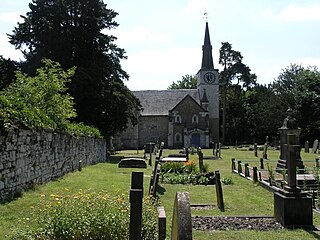
Gatton is a former village in the Borough of Reigate and Banstead, Surrey, England. It survives as a sparsely populated, predominantly rural locality, which includes Gatton Park, no more than 12 houses, and two farms on the slopes of the North Downs near Reigate.

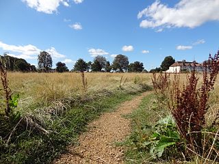
Mogador is a hamlet in the Reigate and Banstead district, in the English county of Surrey. It is at the edge of Banstead Heath, which provides it a green buffer from other communities, and about 12 mile (0.8 km) from the top of the north-facing dip slope of the North Downs. At an elevation of about 200 metres (660 ft) it is one of the highest settlements in south-east England. It is just north of the M25 motorway.

<span class="mw-page-title-main">Margery</span> Human settlement in England

Margery is a heavily buffered, lightly populated hamlet in the Reigate and Banstead district in the English county of Surrey. It sits on the North Downs, is bordered by the London Orbital Motorway, at a lower altitude, and its predominant land use is agriculture.

<span class="mw-page-title-main">Sutton Common</span>

Sutton Common is the name of former common land and a district and neighbourhood located in Sutton, London. The area is mostly located within the London Borough of Sutton, with some of the streets to the north and west of Sutton Common Park adjoining Lower Morden and Morden within the London Borough of Merton. Much of the area is taken up by the large Kimpton Park commercial and industrial estate, adjoining the A217. It is served by Sutton Common railway station. The area to the south and east of Oldfields Road uses an SM1 postcode and the area to the north and west uses SM3.

References

Notes
  1. An increase from 6,219 in 2001.
  2. This valuation was when the hundred was assessed for Ship money in 1636 – Copthorne Hundred's history – H. E. Malden, 1911
References
  1. 1 2 3 4 2001 Census: Collated Statistics (PDF), Surrey County Council, archived from the original (PDF) on 16 June 2013
  2. Census data
  3. 1 2 Domesday Map – Ewell Archived 20 April 2013 at archive.today
  4. 1 2 3 4 5 6 7 8 9 H.E. Malden, ed. (1911). "Parishes: Ewell". A History of the County of Surrey: Volume 3. Institute of Historical Research. Retrieved 4 November 2012.
  5. Victoria County History, 1911 and other editions, e.g. Index Map
  6. "Domesday Map – Burgh". Archived from the original on 1 November 2013. Retrieved 4 November 2012.
  7. 1 2 3 Samuel Lewis, ed. (1848). "Kingswear – Kinlet". A Topographical Dictionary of England. Institute of Historical Research. Retrieved 4 November 2012.
  8. Winchester Diocese Episcopal Registers kept at Wayneflete, i (2) p52
  9. The Methodist Church – find a church, the nearest being on the borders of Burgh Heath at Great Tattenhams St Marks Church
  10. Kingswood Warren, now Kingswood Warren Park, an Octagon Development Archived 19 March 2013 at the Wayback Machine
  11. "History of Kingswood, in Reigate and Banstead and Surrey". A Vision of Britain through Time . Retrieved 27 April 2024.
  12. "Relationships and changes Kingswood CP/ParLib through time". A Vision of Britain through Time. Retrieved 27 April 2024.
  13. "Surrey Mid-Eastern Registration District". UKBMD. Retrieved 27 April 2024.
  14. "Population statistics Kingswood CP/ParLib through time". A Vision of Britain through Time. Retrieved 27 April 2024.
  15. 1 2 Grid reference Finder measurement tools
  16. 1 2 3 4 5 6 7 Map created by Ordnance Survey, courtesy of English Heritage Archived 24 April 2012 at the Wayback Machine
  17. Cranfield University National Soil Resources Institute
  18. 1 2 Reigate and Banstead BC. Directory of local parks and countryside in the Borough, including details about facilities at each Archived 1 November 2013 at the Wayback Machine
  19. H.E. Malden, Victoria County History 1911 – Burgh Heath
  20. 1 2 Brayley, Edward Wedlake; Britton, J. (1842). A Topographical History of Surrey. p. 273. Retrieved 27 July 2011.
  21. Kingswood Warren
  22. Kingswood Court luxury residential and respite care Archived 22 October 2012 at the Wayback Machine
  23. 1 2 "Kingswood, St Andrew: Parish Records, 1836–1990". Surrey History Centre. Retrieved 26 July 2011.
  24. St Andrew's Church – The Church of England Website
  25. St Mary's Church – The Church of England Website
  26. Lower Kingswood, Church of Jesus Christ and the Wisdom of God – Architecture Historic England. "Details from listed building database (1029052)". National Heritage List for England . Retrieved 4 November 2012.
  27. Church of Jesus Christ and the Wisdom of God – The Church of England
  28. "Vera Brittain's Testament of Youth". Essential Surrey. 19 January 2015. Archived from the original on 10 April 2017. Retrieved 9 April 2017.
  29. Kingswood Golf Club
  30. Surrey Downs Golf Club
  31. National Rail
  32. "The UK's kleptocracy problem: How servicing post-Soviet elites weakens the rule of law" (PDF). Russia and Eurasia Programme. Archived from the original (PDF) on 18 January 2022. Retrieved 24 February 2022.
Kingswood
Burgh Heath