Mechanicsville, Iowa | |
---|---|
Coordinates: 41°54′N91°15′W / 41.900°N 91.250°W Coordinates: 41°54′N91°15′W / 41.900°N 91.250°W | |
Country | United States |
State | Iowa |
County | Cedar |
Government | |
• Type | Mayor-council |
• Mayor | Andrew J. Oberbreckling |
Area | |
• Total | 0.83 sq mi (2.14 km2) |
• Land | 0.82 sq mi (2.14 km2) |
• Water | 0.00 sq mi (0.01 km2) |
Elevation | 922 ft (281 m) |
Population (2020) | |
• Total | 1,020 |
• Density | 1,237.86/sq mi (477.67/km2) |
Time zone | UTC-6 (Central (CST)) |
• Summer (DST) | UTC-5 (CDT) |
ZIP code | 52306 |
Area code | 563 |
FIPS code | 19-50700 |
GNIS feature ID | 0458943 |
Website | www |
Mechanicsville is a city in Cedar County, Iowa, United States. The population was 1,020 at the time of the 2020 census. [2]
Mechanicsville was platted in 1855 by Daniel A. Comstock. [3] It was so named from the fact several of its first settlers were mechanics. [4] [5] A fire in 1883 destroyed the south side of the business district. [6]
Mechanicsville is located at 41°54′N91°15′W / 41.900°N 91.250°W (41.905, -91.253). [7]
According to the United States Census Bureau, the city has a total area of 0.83 square miles (2.15 km2), all land. [8]
Year | Pop. | ±% |
---|---|---|
1860 | 195 | — |
1870 | 628 | +222.1% |
1880 | 545 | −13.2% |
1890 | 612 | +12.3% |
1900 | 703 | +14.9% |
1910 | 817 | +16.2% |
1920 | 812 | −0.6% |
1930 | 781 | −3.8% |
1940 | 821 | +5.1% |
1950 | 850 | +3.5% |
1960 | 866 | +1.9% |
1970 | 989 | +14.2% |
1980 | 1,166 | +17.9% |
1990 | 1,075 | −7.8% |
2000 | 1,173 | +9.1% |
2010 | 1,146 | −2.3% |
2020 | 1,020 | −11.0% |
Source: "U.S. Census website". United States Census Bureau . Retrieved 2020-03-29. and Iowa Data Center Source: |
As of the census [10] of 2010, there were 1,146 people, 471 households, and 315 families living in the city. The population density was 1,380.7 inhabitants per square mile (533.1/km2). There were 496 housing units at an average density of 597.6 per square mile (230.7/km2). The racial makeup of the city was 97.8% White, 0.3% African American, 0.2% Native American, 0.3% Asian, 0.3% from other races, and 1.0% from two or more races. Hispanic or Latino of any race were 1.7% of the population.
There were 471 households, of which 28.7% had children under the age of 18 living with them, 52.4% were married couples living together, 8.9% had a female householder with no husband present, 5.5% had a male householder with no wife present, and 33.1% were non-families. 28.2% of all households were made up of individuals, and 14.3% had someone living alone who was 65 years of age or older. The average household size was 2.34 and the average family size was 2.83.
The median age in the city was 43.1 years. 22.9% of residents were under the age of 18; 6.9% were between the ages of 18 and 24; 22.7% were from 25 to 44; 29.2% were from 45 to 64; and 18.5% were 65 years of age or older. The gender makeup of the city was 47.8% male and 52.2% female.
As of the census [11] of 2000, there were 1,173 people, 452 households, and 312 families living in the city. The population density was 1,582.5 inhabitants per square mile (611.0/km2). There were 479 housing units at an average density of 646.2 per square mile (249.5/km2). The racial makeup of the city was 98.21% White, 0.09% African American, 0.51% Native American, 0.09% Asian, 0.09% from other races, and 1.02% from two or more races. Hispanic or Latino of any race were 1.36% of the population.
There were 452 households, out of which 33.8% had children under the age of 18 living with them, 54.6% were married couples living together, 9.5% had a female householder with no husband present, and 30.8% were non-families. 27.0% of all households were made up of individuals, and 14.8% had someone living alone who was 65 years of age or older. The average household size was 2.46 and the average family size was 2.97.
25.5% are under the age of 18, 7.9% from 18 to 24, 27.8% from 25 to 44, 19.0% from 45 to 64, and 19.8% who were 65 years of age or older. The median age was 38 years. For every 100 females, there were 90.1 males. For every 100 females age 18 and over, there were 84.4 males.
The median income for a household in the city was $36,053, and the median income for a family was $44,500. Males had a median income of $32,054 versus $23,125 for females. The per capita income for the city was $16,429. About 5.8% of families and 7.9% of the population were below the poverty line, including 11.4% of those under age 18 and 6.0% of those age 65 or over.
The North Cedar Community School District serves the community. [12] It was established on July 1, 1995, by the merger of the Clarence-Lowden Community School District and the Lincoln Community School District. [13]
Cedar County is a county located in the U.S. state of Iowa. As of the 2020 census, the population was 18,505. Its county seat is Tipton. The county is named for the Cedar River, which runs through the county.
Luzerne is a city in Benton County, Iowa, United States. The population was 112 at the time of the 2020 census. It is part of the Cedar Rapids Metropolitan Statistical Area.
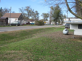
Mount Auburn is a city in Benton County, Iowa, United States. The population was 162 at the time of the 2020 census. It is part of the Cedar Rapids Metropolitan Statistical Area.
Newhall is a city in Benton County, Iowa, United States. The population was 876 at the time of the 2020 census. It is part of the Cedar Rapids Metropolitan Statistical Area.
Norway is a city in Benton County, Iowa, United States. The population was 466 at the time of the 2020 census. The city is approximately 17 miles (27 km) southwest of downtown Cedar Rapids. It is part of the Cedar Rapids Metropolitan Statistical Area. Norway is the setting of the movie The Final Season.
Urbana is a city in Benton County, Iowa, United States. The population was 1,554 at the time of the 2020 census. It is part of the Cedar Rapids Metropolitan Statistical Area.
Denver is a city in Bremer County in the U.S. state of Iowa. The population was 1,919 at the time of the 2020 census. It is part of the Waterloo–Cedar Falls Metropolitan Statistical Area.
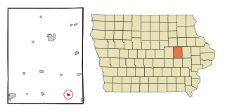
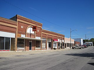
Clarence is a city in Cedar County, Iowa, United States. The population was 1,039 at the time of the 2020 census.
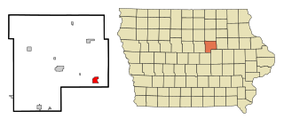
Lowden is a city in Cedar County, Iowa, United States. The population was 807 at the time of the 2020 census.
Stanwood is a city in Cedar County, Iowa, United States. The population was 637 at the time of the 2020 census.
Reinbeck is a city in Grundy County, Iowa, United States. The population was 1,662 at the 2020 census—a five percent decrease from the population of 1,751 in 2000. It is part of the Waterloo–Cedar Falls Metropolitan Statistical Area and is in the Cedar Valley.
Keswick is a city in Keokuk County, Iowa, United States. The population was 242 at the time of the 2020 census.
Thornburg is a village in Keokuk County, Iowa, United States. The population was 45 at the time of the 2020 census. Its sole enterprise is the Tri-County Community School, a public school serving grades K-12.
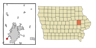
Central City is a city in Linn County, Iowa, United States. The population was 1,264 at the 2020 census. It is part of the Cedar Rapids Metropolitan Statistical Area.
Coggon is a city in Linn County, Iowa, United States. The population was 701 at the time of the 2020 census. It is part of the Cedar Rapids Metropolitan Statistical Area.
Fairfax is a city in Linn County, Iowa, United States. The population was 2,828 at the time of the 2020 census. It is part of the Cedar Rapids Metropolitan Statistical Area.
Palo is a city in Linn County, Iowa, United States. The population was 1,407 at the time of the 2020 census. It is part of the Cedar Rapids Metropolitan Statistical Area.
Prairieburg is a city in Linn County, Iowa, United States. The population was 160 at the time of the 2020 census. It is part of the Cedar Rapids Metropolitan Statistical Area.
Robins is a city in Linn County, Iowa, United States. The population was 3,353 at the time of the 2020 census. It is a suburb of Cedar Rapids and part of the Cedar Rapids Metropolitan Statistical Area.
Fredonia is a city in Louisa County, Iowa, United States. The population was 222 at the time of the 2020 census. It is part of the Muscatine Micropolitan Statistical Area.